
Natural Capital Tool
Supporting integrated and collaborative approaches to land management.
The NatureScot Natural Capital Tool is a free, easy-to-use decision support tool that facilitates a natural capital approach to land management in Scotland. A natural capital approach is when the full range of benefits that we receive from nature are taken into consideration throughout the decision making process. Adopting a natural capital approach enables us to understand the role of our natural environment, alongside its intrinsic value, as an asset that underpins both our economy and society.
Nature provides a whole host of benefits that we are dependent on, known as ecosystem services, that are often overlooked in land management decisions. In order for these benefits to be included in decision making, we need the methods and tools to quantify them. By mapping and modelling how certain land use changes might impact the ecosystem services they provide, decision makers can identify the scenarios and opportunities that provide the most benefits for both people and nature.
Led by NatureScot and developed with Liverpool John Moores University and EOLAS Insight, the Natural Capital Tool builds on EcoServR, an existing natural capital mapping toolkit in the coding language R. Since 2022, the Natural Capital Tool has been developed so that the functionality of the tool, the ecosystem services that are measured, and the end product are bespoke for Scotland. The following criteria outline the tool development’s guiding principles:

The Natural Capital Tool aims to support land managers and decision makers to:
- Access relevant datasets and evidence by democratising natural capital information and making it accessible for all;
- Save time and money through improved decision making, allowing users to take a strategic approach to land management;
- Prioritise interventions so that the environmental benefits from nature can be provided to the communities, habitats and wildlife that need it most;
- Examine the gains and losses in ecosystem services and habitat connectivity associated with different land use interventions; and
- Align with emerging nature finance markets by helping users to collaborate at the landscape scale, allowing users to aggregate investment opportunities.
Key features of the Natural Capital Tool:

Key Features
Click for a full description
- Natural capital baseline mapping
- Ecosystem service capacity and demand mapping
- Habitat network mapping
- Landscape-scale opportunity mapping
- Scenario planning
- Ecosystem service uplift prediction
Once users have gone through the tool, they are then able to export an automated report, which summarises the outputs of the tool and signposts users to relevant resources and funding opportunities based on the interventions they have made. Whilst the key features outlined above facilitate project development, the automated report supports users through to project delivery by providing them with a tangible record of their progress in the tool, which can be presented to funding bodies or used when engaging with relevant stakeholders.
If you would like to get access to the Natural Capital Tool, please fill in this form. Once access has been confirmed, you can head over to natcaptool.nature.scot and make an account within the tool. We have developed a range of resources to support you in using the tool: a step-by-step Tool User Guide, the Methodology Report, and a real-time video demonstration (see below). Finally, the Natural Capital Tool team are always on hand to provide support in using the tool, and they can be contacted by emailing [email protected].
The Natural Capital Tool is still in Beta testing, and we will continue to iterate and push updates over the next coming weeks and months. We will be collecting feedback from users of the tool and organisations who are piloting the tool on the ground. If you are involved in a project that you think might benefit from the Natural Capital Tool and would be interested in learning more about piloting, please get in touch by emailing us at [email protected].
The NatureScot Natural Capital Tool
Click for a full description
Duration
09:57
The NatureScot Natural Capital Tool is a free, easy-to-use decision support tool that facilitates a natural capital approach to land management in Scotland. A natural capital approach is when the full range of benefits that we receive from nature are taken into consideration throughout the decision making process. Adopting a natural capital approach enables us to understand the role of our natural environment, alongside its intrinsic value, as an asset that underpins both our economy and society. In this demonstration, we take you through the different steps included in the tool and how it can be integrated into your decision making.
Nature provides a whole host of benefits that we are dependent on, known as ecosystem services, that are often overlooked in land management decisions. In order for these benefits to be included in decision making, we need the methods and tools to quantify them. By mapping and modelling how certain land use changes might impact the ecosystem services they provide, decision makers can identify the scenarios and opportunities that provide the most benefits for both people and nature.
Led by NatureScot and developed with Liverpool John Moores University and EOLAS Insight, the Natural Capital Tool builds on EcoServR, an existing natural capital mapping toolkit in the coding language R. Since 2022, the Natural Capital Tool has been developed so that the functionality of the tool, the ecosystem services that are measured, and the end product are bespoke for Scotland.
If you would like to learn more, please visit natcaptool.nature.scot, or email us at [email protected].
To help you get to know the tool a bit better, we have answered some commonly asked questions in the boxes below.
What is natural capital?
Natural capital refers to the elements of nature that hold societal value, such as habitats, ecosystems, and animal/plant species. Natural capital includes both the living and non-living aspects of ecosystems. View our What is Natural Capital? video to learn more.
What are ecosystem services?

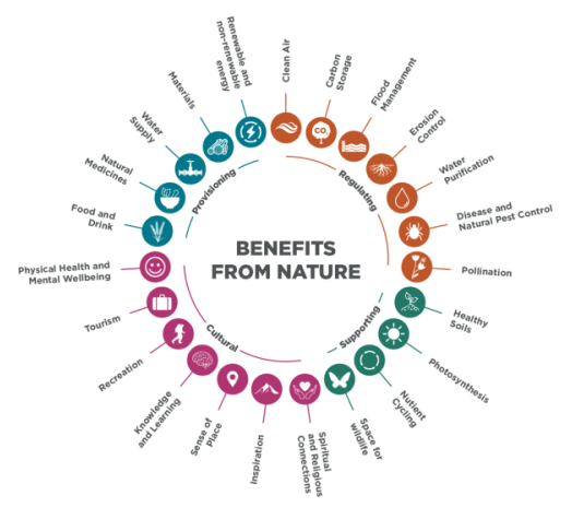
Ecosystem services are the benefits that natural capital provides to people, such as insect pollination, flood mitigation, and carbon sequestration.
The benefits from nature can be divided into four categories:
Provisioning – these are tangible goods that people can harvest from the environment such as food, timber, water, renewable and non-renewable energy, natural medicines and materials.
Regulating – these are the benefits from regulation of ecosystem processes such as clean air, carbon storage, temperature regulation, flood management, water purification, erosion control, insect pollination and disease and natural pest control.
Supporting – ecosystems cannot function without the services of the nutrient cycle, soil formation, photosynthesis and habitat provision for biodiversity, forming the basis for the other three types of services.
Cultural – non-material benefits that people derive from interacting with nature such as mental wellbeing and physical health, aesthetic inspiration, tourism, recreation, knowledge and learning sense of home and spirituality.
Who is the Natural Capital Tool for?
The Natural Capital Tool is aimed at any decision maker who is interested in exploring how to integrate natural capital approaches into the management of their land. Potential users include farmers/crofters, local authorities, landscape-scale restoration projects, consultants, and many others. The Natural Capital Tool was co-designed with a wide range of stakeholders spanning many sectors and industries to ensure that it is relevant, useful and accessible to different types of users.
Where is covered by the Natural Capital Tool?
The Natural Capital Tool applies exclusively to Scotland, covering both the mainland and the extent of Scotland’s islands. The Natural Capital Tool runs in both urban and rural settings, with our bespoke habitat baseline providing up to 5x5 m granularity. Learn more about our habitat baseline in the Methodology Report.
Currently, the size of the target area is limited to 150 km2 so we can work on optimising our models to work faster at larger scales, but the aim is to increase the target area size limit to 1000 km2.
What ecosystem services are modelled in the Natural Capital Tool?
We developed our ecosystem service models by building on the existing EcoServR methodology and through workshops with subject matter experts. These include:

- Insect pollination
- Access to nature
- Inland flood mitigation
- Noise regulation
- Local climate regulation
- Carbon sequestration
- Air quality improvement
Our co-design group also highlighted that ‘River Cooling’ and ‘Coastal Flood Mitigation’ ecosystem services should be represented in the tool. We ran workshops for these ecosystem services and identified existing models which have been pulled into the tool to support decision making.
How do the ecosystem service models work?
Ecosystem services are presented to users in three ways: 1) users can view the existing capacity of a target area to provide an ecosystem service (e.g., to what extent an area of land is providing land users with pollination services); 2) users can view the demand that exists for certain ecosystem service provision (e.g., the need for increased access to nature); 3) users are then presented with the opportunities to boost that ecosystem service, and these are found in areas of low capacity and high demand. The parameters used to generate capacity are based on national, open access datasets and values acquired through consultation with subject matter experts and literature reviews. The demand models use socio-economic datasets, such as census data and the Scottish Index for Multiple Deprivation (SIMD), and highlight priority areas, such as vital infrastructure and arable land, to indicate areas where the provision of an ecosystem service would benefit local communities.
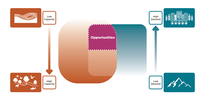
Ecosystem service opportunities exist in areas that have low capacity for providing a service and high demand for that service.
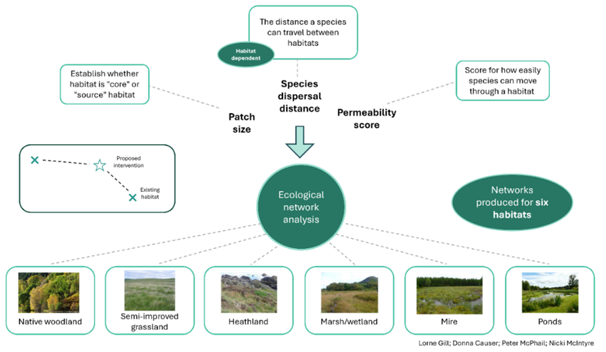
How do the habitat network models work?
The Natural Capital Tool can display habitat networks for six habitat types: woodland, grassland, heath, mire/bog, wetland, and ponds. Habitat networks refer to the connectedness of a specific habitat and the ability of species associated with that habitat to move within the landscape. Each layer shows the existing (core) habitat of the selected habitat type, as well as the areas of “usable space” around the core habitat in which species associated with that habitat could move. This is done using a cost distance analysis, where habitats are scored depending on how easily species can move through it.

The ecological parameters used to develop the six habitat networks presented in the tool.
Click for a full description
What additional information is in the Natural Capital Tool?
To help you contextualise all the information within the tool and to support your decision making, we have hand picked a selection of 'Context Layers'. These layers are not datasets that we have created or own, but they provide additional helpful information that you might want to consider when exploring the tool.
These context layers fall into the following categories:
- Transport
- Boundaries and Protected Sites
- Habitats and Networks (these are additional to the habitat network models we create)
- Agriculture
- Water and Coasts
- Biodiversity
Where can I find the Natural Capital Tool Methodology Report?
The Natural Capital Tool Methodology Report outlines the tool’s development process, covering both the engagement and technical aspects of its development. In the Methodology Report, you can also find the parameters and datasets used for the models incorporated into the Natural Capital Tool. This can be found in the About section of the Natural Capital Tool.
Who was included in the co-design group for the Natural Capital Tool?
The Natural Capital Tool was co-designed with over 60 different relevant organisations, comprising over 160 individuals across nine sectors. The co-design process is ongoing, but up to now, the process has included: six co-design workshops focusing on general tool functionality; six ecosystem service model workshops bringing together subject matter experts on particular ecosystem services; and a pilot phase where we tested an early tool prototype with seven projects of varying scales (local community groups to National Parks).

What are the caveats and limitations?
- As the tool is currently in Beta testing, it is subject to ongoing refinement and we will be continuing to iterate and push updates throughout the coming weeks and months. As such, both the tool and associated methodology may be subject to change.
- The tool currently only has a maximum area of 150 km2. This is subject to change, and we are aiming for Loch Lomond and Trossachs National Park size (approx. 1800 km2)!
- The tool doesn't currently determine habitat / intervention suitability. For example, if you want to create an intervention where trees are planted above the treeline, or a blanket bog is created where there is no peat, then the tool will allow it. There needs to be some level of site knowledge and ground-truthing for the area you are exploring. It is a decision support - not a decision making - tool.
- Habitat ‘condition’ is not currently incorporated into the tool at the moment, but this is something we are working on. The relationship between habitat condition and ecosystem provision is non-linear and complex. The models assume that the habitat is capable of providing the ecosystem services associated with that habitat type and makes no adjustment for condition. You can model a change in habitat condition for some habitats by changing the habitat itself. For example, you could model the change from enhancing an area of amenity grassland to a semi-natural grassland.


