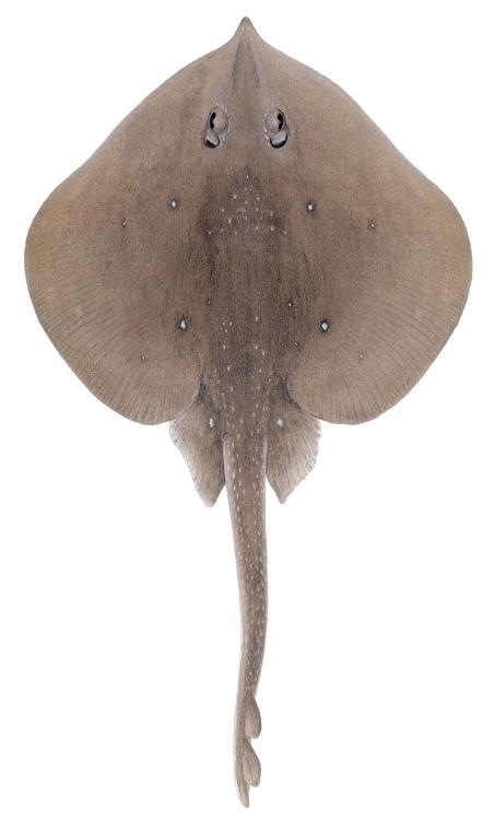
Sharks and Skates of Scotland Report: Sandy skate (Leucoraja circularis)
An extract from the Sharks and Skates of Scotland Report.
Sandy skate - Leucoraja circularis (Couch, 1838)
Occurrence in Scotland: Slope and deep-water. Resident. Also found on the upper continental slope around Scotland and around Rockall. Found sporadically on the continental shelf in all Scottish waters.
Synonym(s): Raja circularis. Early reports often confused Leucoraja circularis and Leucoraja naevus (Mccully-Phillips et al., 2015); Order: Rajiformes; Family: Rajidae
Common name: Sandy skate, Sandy ray
AlphaID: 105873 TSN Code: 564128
Population status
Scotland and Northeast Atlantic: Declining population in the Northeast Atlantic since the 1990s, and the species is now considered rare (Ellis et al., 2015).
Global: Decreasing. Sandy Skate is inferred to have undergone a population reduction of 30–49% over the past three generation lengths (36 years) based on abundance data and actual levels of exploitation (Finucci et al., 2025).
Conservation listings
- IUCN Red List Global and Europe: Vulnerable (assessment 20 February 2024)
- CITES: Not listed
- CMS: Not Listed
- OSPAR: Not listed
- Listed as a Priority Marine Feature in Scotland’s seas
- Scottish Biodiversity List
- Feature of Conservation Importance in England and Wales (FOCI)
Range and distribution
Two sub-populations of Sandy skate exist, one in the North Atlantic and one in the Mediterranean. Sandy skate are mainly found off the north coast of Scotland and around the Shetland Isles but also in deeper waters west of Ireland (especially the Porcupine Banks) and the UK, with occasional records in the Celtic Sea. Evidence from Scottish surveys suggests that the species has shifted to deeper waters than it historically inhabited and is now primarily recorded along the edge of the continental shelf in depths of 180–500 m.
More generally, in the Northeast Atlantic, Sandy skate are found from Norway and Iceland to Morocco and Western Sahara (Maurin 1968, Guliugyn et al., 2006), and possibly to Mauritania and Senegal (Last et al., 2016, Ebert and Dando 2021).
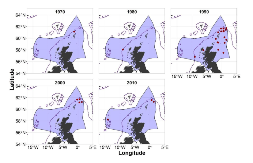
ICES DATRAS records for Sandy skate (Leucoraja circularis) for 1970: 1970-1979; 1980: 1980-1989; 1990: 1990-1999; 2000: 2000-2009; 2010:2010-2019.
Click for a full description
Five maps of the economic exclusion zone (EEZ) of Scotland showing locations of trawls where Sandy skate (Leucoraja circularis) were captured from 1970 to 1979, 1980 to 1989, 1990 to 1999, 2000 to 2009, and 2010 to 2019. Red points represent trawl shoot locations in which Sandy skate (L. circularis) were captured. From 1970 to 1979 there is a single record for the capture of Sandy skate in a trawl conducted on the northern edge of the continental shelf north of the Shetland Isles. From 1980 to 1989 Sandy skate were recorded in a single trawl conducted on the western edge of the continental shelf west of the Outer Hebrides. From 1990 to 1999 records are more numerous and more widely distributed, covering much of the northern North Sea with additional records in the northern Minch and at the edge of the continental shelf to the west of the Isle of Barra. From 2000 to 2009 records are fewer and are clustered exclusively at the northernmost point of the continental shelf north of the Shetland Isles. From 2010-20919 there are again a few records north of the Shetland Isles and a single record representing Sandy skate caught in a single trawl on the northern most edge of the Rockall Plateau. A change in the number or distribution of records over time does not reflect a change in occurrence or abundance since data have not been corrected for effort.
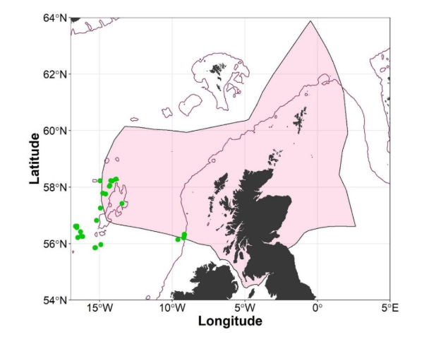
Records for Sandy skate (Leucoraja circularis) from SIAMISS and deep-water fisheries surveys undertaken by Marine Directorate 1996 – 2019.
Click for a full description
Map of the economic exclusion zone (EEZ) of Scotland showing records for Sandy skate (Leucoraja circularis) from the Scottish-Irish anglerfish and megrim industry-science survey (SIAMISS) and deep-water fisheries surveys undertaken by Marine Directorate 1996-2019. Records are illustrated as green points, there are 2 groups of records, a small cluster at the edge of the continental shelf to the west of the Isle of Barra and a larger one on and around the west of the Rockall Plateau.
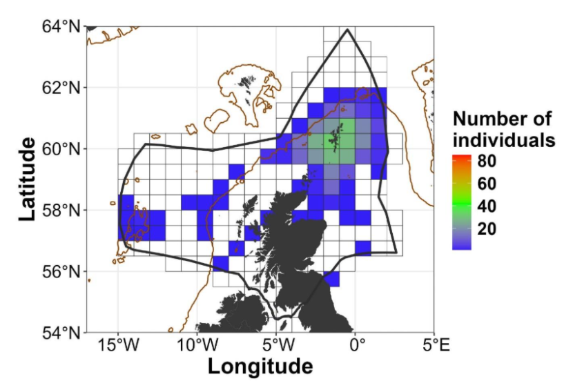
Landings data from commercial fishing vessels in ICES rectangles for Sandy skate (Leucoraja circularis) 2011-2019. Data is filtered to exclude information in rectangles where three vessels or less operate.
Click for a full description
Map of the economic exclusion zone (EEZ) of Scotland showing landings data for Sandy skate (Leucoraja circularis) recorded on commercial fishing vessels from 2011 to 2019. The EEZ of Scotland is covered by a grid dividing it into the International Council for the Exploration of the Sea (ICES) rectangles. Data is filtered to exclude information in rectangles where three vessels or less operate. Values are presented as individuals per trip and represented as a heat map, colouring each ICES rectangle from 1 (blue) to 81 (red). Small numbers of landings, illustrated by blue rectangles representing 1 to 10 individuals, were reported patchily along the edge of the continental shelf to the west and northwest of the Outer Hebrides, in the Moray Firth, in the northern North Sea, on and around the Rockall plateau, around the south of the Isle of Skye, around the Isle of Barra, to the south of the Isle of Barra and around the Orkney Isles. Higher numbers of landings, approximately 30 per trip represented by green rectangles were recorded around the Shetland Isles.
Habitat
Sandy skate are a benthic species of the outer continental shelf and upper slope, occurring at depths of 70–800 m, and are most common in waters deeper than 350 m (Last et al., 2016, Ebert and Dando 2021, Finucci et al., 2025).
Biology and Ecology
Sandy skate are a relatively large skate species, reaching a maximum size of ~120 cm total length; males mature at 78 cm TL and females mature at 99 cm TL (Finucci et al., 2025). Reproduction is oviparous, but the egg-laying season, fecundity, and size-at-hatching are all unknown (Finucci et al., 2025). Comparison with similar species suggests Sandy skate are slow-growing, with low fecundity and large juveniles, and an estimated generation length (the number of years between the birth of a parent and the birth of a child) of 12 years (Finucci et al., 2025).
Human interactions
The relatively large body size of Sandy skate makes them susceptible to overfishing across much of their current range and in most size classes. Although they are not generally targeted in the Northeast Atlantic, Sandy skate are taken as bycatch in mixed demersal trawl fisheries operating in the outer parts and on the slope of the continental shelf, and they are a marketable species (Finucci et al., 2025). In the Mediterranean, the species is subject to extensive and intensive fishing across much of its known depth and spatial distribution. ICES advises that landings should be no more than 27 tonnes in each of the years 2025–2028 (ICES 2024).
References
Ebert, D.A. and Dando, M. 2021. Field guide to sharks, rays & chimaeras of Europe and the Mediterranean. Princeton University Press, Plymouth, U.K.
Finucci, B., Ellis, J.R., McCully-Phillips, S.R., Serena, F. & Charles, R. 2025. Leucoraja circularis. The IUCN Red List of Threatened Species 2025: e.T161464A124490090.
ICES (2024) ‘Sandy ray (Leucoraja circularis) in subareas 6–7 (West of Scotland, southern Celtic Seas, English Channel)’, ICES Advice on fishing opportunities, catch, and effort. Rji.27.67.
Last, P., White, W., de Carvalho, M., Séret, B., Stehmann, M. and Naylor, G. 2016. Rays of the World. CSIRO Publishing, Clayton.


