NatureScot Research Report 1409 - Deer Vehicle Collisions - a review of mitigation measures and their effectiveness - applying the findings at a site-specific scale (the Isle of Lewis and Harris)
Year of publication: 2026
Authors: Langbein, J. (Langbein Wildlife Associates)
Cite as: Langbein, J. (Langbein Wildlife Associates) Deer Vehicle Collisions - a review of mitigation measures and their effectiveness - applying the findings at a site-specific scale (the Isle of Lewis and Harris) NatureScot Research Report 1409.
Keywords
Isle of Lewis and Harris, roads, deer, “deer vehicle collision”, “wildlife vehicle collision”, mitigation.
Background
NatureScot and Transport Scotland together commissioned a report in 2024 reviewing deer vehicle collision (DVC) mitigation measures at an international scale and providing an assessment of their efficacy and cost effectiveness. An overriding conclusion was that applying any single mitigation measure in isolation will rarely produce lasting reductions in DVCs, and that the choice of suitable combinations of measures requires thorough evaluation of site-specific conditions.
In an extension of the above review, they set out to investigate what might be the potentially most suitable mitigation options at a site-specific scale for a selection of areas identified at that time as Scottish DVC hotspots. The aim was to help identify mitigation options for possible implementation at these and other comparable locations on the Scottish road network.
Two site-specific studies considered suitable mitigation options for three major trunk road interchanges in Central Scotland that had previously been identified as DVC hotspots on the M8 and M9 motorways and A82 (dual carriageway), and a section of single-lane trunk road (A9) near Helmsdale in East Sutherland with high levels of DVCs over recent years.
By contrast to the previous studies based along trunk roads, the primary focus of this further study is several sections of non-trunk A-roads on the Isle of Lewis and Harris (hereafter also referred to as Lewis & Harris). In addition, some sections of more minor roads were also inspected. Average annual daily traffic (AADT) flows along A-roads on Lewis & Harris (1000 – 2250 vehicles per day) are considerably lower than for the trunk road sites considered in the previous studies in the Central Belt (> 30,000 vehicles per day for M9 and A82; and > 70,000 for M8), or along the A9 north and south of Helmsdale (approximately 3000 vehicles per day) (DfT Road Traffic Stats 2023, online). Numbers of DVCs recorded on Lewis & Harris have been noted to rise significantly over the last decade, despite apparently relatively stable reported levels of road traffic over the same period for the island as a whole. This provided an opportunity to explore the underlying reasons for that escalation of DVCs on non-trunk roads, and which mitigation options might be best suited to such regions with relatively low past traffic volumes.
Assessments included desk top review of numbers and distribution of recorded DVCs on Lewis & Harris and past deer population counts. In addition, two field visits were undertaken during October and November 2025. Work included i) consultation with landholders (via Lewis and Harris Deer Management Group (DMG)) and the local Council roads department, ii) inspection by car and on foot of selected road sections where highest incidence of DVC has been recorded, iii) roadside thermal imaging deer surveys at night, and iv) some trials of camera-trap filming of deer at roadsides. Based on the findings, proposals for a combination of mitigation options thought most suitable for the local road network as a whole or specific sites within it are put forward for consideration.
Main findings
- Assessment of site-specific seasonal variation in deer vehicle collisions (DVCs) helps to inform the appropriateness and optimal timing of mitigation interventions, including deployment of mobile variable message signage (VMS) and targeted management of deer populations adjacent to high-risk road segments.
- On Lewis & Harris, DVC incidence exhibits a pronounced seasonal peak between September and mid-December, with consistently highest collision frequencies recorded in October (once) or November (twice) across the past three years.
- Helicopter surveys over parts of Lewis & Harris in 2013 and 2022 indicate that across the extent of the island covered by both counts, the number of red deer has doubled. While historically concentrated on Harris, deer are now also widely distributed across much of Lewis.
- DVC risk is now widespread across the island, affecting most non-urban roads. However, five A-road sections have been identified as priority high-risk areas where additional targeted mitigation is likely to be most effective.
- Unlike many mainland Scottish DVC hotspots - where trees or other dense roadside vegetation is a key factor - only one of the five priority sites on Lewis & Harris (Aline Woods) is influenced by such cover close the road. The remaining sites are characterised by long, straight road sections with generally good visibility, though several blind summits present localised hazards.
- A single mitigation measure used in isolation is unlikely to lead to a sustained reduction in DVCs. Best results are likely to be achieved through combining a range of complementary measures, including engagement with landholders and the local community.
- An initial DVC reduction strategy should prioritise island-wide measures to raise driver awareness of high-risk locations, seasons, and times of day. Seasonal deployment of mobile VMS should be considered at some or all priority sites.
- For one priority site (Aline Woods) pilot implementation of a Roadside Animal Detection System (RADS) could be a suitable year-round alternative to seasonal use of mobile VMS.
- Continued management of the deer population at sustainable levels throughout the island, and avoidance of build-up of high densities near roadsides in the priority areas, will remain an important part of DVC prevention alongside any other mitigation measures implemented.
- Ongoing DVC data collection should be maintained and refined to improve spatial accuracy, to enhance capacity to detect and monitor collision hotspots over time. Annual night-time drone surveys of deer presence along the five priority road sections would enable more objective evaluation of mitigation effectiveness, including comparative analysis between sites with and without VMS deployment, while accounting for concurrent variation in deer abundance.
Acknowledgments
The author would like to thank NatureScot and Transport Scotland for funding this work, and for advice and support throughout by in particular Dominic Sargent (NatureScot project lead) and Mark Jamieson (NatureScot wildlife management officer). Many thanks are due also to Angus Corby (Transport Scotland), Chris Macrae (Lewis and Harris Deer Management Group), and John Macleod (Comhairle nan Eilean Siar).
Abbreviations
Deer Vehicle Collision (DVC)
Wildlife Vehicle Collision (WVC)
Wildlife Management Officer (WMO)
Deer Management Group (DMG)
Lewis and Harris DMG (LHDMG)
Trunk Road Operating Companies (TROC)
Roadside Animal Detection System (RADS)
Variable Message Sign (VMS)
Average Annual Daily Traffic (AADF)
Ordnance Survey (OS)
*1 RADS of differing types are based on either radar units or small roadside devices with thermal motion sensors to detect deer on the carriageway or approaching the verges. The presence of any live animals detected may be relayed to digital warning signs at their end of the protected sections; and in some cases, the roadside devices themselves can also emit flashing signals to forewarn drivers.
Contents
- Keywords
- Background
- Main findings
- Acknowledgments
- Abbreviations
- Introduction
- Study Location and Approach
- Findings from desk-study and field visits
- Discussion of Results
-
Potential mitigation options
- Mitigation measures suited to minor roads and single lane A-roads in general.
- A proposed DVC mitigation Strategy for Lewis & Harris
- Island-wide DVC mitigation measures
- Combinations of potential site-specific mitigation measures
- Other measures not thought suitable for the selected locations
- Monitoring the effectiveness of a DVC strategy
- Conclusions
Introduction
Rising traffic volumes combined with range expansion of the four deer species living wild in Scotland over the past two decades have led to deer vehicle collisions (DVCs) becoming increasingly common, not just in rural but also peri-urban and even some urban parts of Scotland.
NatureScot and Transport Scotland have been monitoring annual trends in numbers and distribution of DVCs for over two decades (Langbein & Putman 2006; Langbein, 2011, 2019; Lush and Lush 2023, 2026). The trunk road and motorway network, which carries 35% of all traffic and 60% of heavy goods vehicles in Scotland (Transport Scotland, 2024), has formed a particularly important aspect throughout the national DVC monitoring work. The Scottish trunk road network connects Scotland's major cities, towns, airports and ports and is hugely diverse. Motorways and other dual carriageways (including slip roads and roundabouts) constitute only 38% of the total length of the Scottish trunk road network, with the remaining 62% (2,307 km) comprising single carriageway A-roads (see Transport Scotland, 2020 for full breakdown).
As an extension to a recent NatureScot and Transport Scotland-commissioned report reviewing deer-vehicle collision (DVC) mitigation measures at an international scale and providing an assessment of their efficacy and cost effectiveness (Putman and Langbein, 2024), a project investigating potentially suitable mitigation options at a site-specific scale was initiated.
The two previous site-specific studies investigated suitable mitigation options for three major trunk road interchanges identified as DVC hotspots in Central Scotland, and a fourth hotspot along a single-lane trunk A-road in the Highlands.
The aim of this project was to help identify the most suitable mitigation options or combined strategies of measures for implementation at a range of non-trunk road sections on Lewis & Harris. It is hoped that these may also help to inform suitable approaches to DVC mitigation at comparable non-trunk road situations elsewhere on the Scottish road network.
With some DVC hotspots the principal factors leading to increased localised risk of collisions may be straightforward to identify. The sites for the two earlier studies were chosen from among the top ten DVC hotspots identified by analysis of available DVC reports for 2019-2021 (Lush & Lush 2023). Nine of those were located at major trunk road interchanges, and only one along single-lane A-road (also a trunk road). For hotspots considered at major trunk road interchanges, the combination of high traffic volumes and presence of large expanses of woody scrub habitat surrounded by tarmac on all sides results in deer crossing into and settling in high-risk locations. At the hotspot investigated in East Sutherland, the high incidence of DVCs for that single-lane A-road was attributable to a large extent to the frequent passage of deer across the road, mostly between dusk and dawn, as they moved from shelter used on moorland hillsides west of the road during the day to the low lying coastal grazing on the eastern side at night.
By contrast to the above sites, the underlying reasons for the DVCs noted across Lewis & Harris are rather less readily attributable to any single factor.
The locations currently with the highest incidences of reported DVCs on the island do coincide with areas of woodland or other shelter close to roads in some areas (e.g. Aline Woods) but involve only a moderate proportion of the recorded DVCs, with many other DVCs located in very open areas of moorland with seemingly good visibility for drivers and deer.
The island’s deer populations have increased noticeably over the last two decades whereas the resident human population and recorded road traffic volumes have been experiencing only limited growth, although ongoing major infrastructure projects on Lewis & Harris, particularly in connection with the Western Isles High Voltage Direct Current Link Project (including replacement of the 60 km overhead electricity line from Tarbet to Stornoway) have contributed to recent, localised rises in road traffic, and extensive helicopter activity associated with pole delivery and erection may have led to the temporary displacement of deer.
For the present study therefore, rather than focussing only on hotspots that had already been identified as in the earlier projects, it was decided to undertake more wide-ranging surveys of much of the island’s network of main A-roads as well as some minor roads where several DVCs have been reported. Following desk-top review and collations of relevant past information, fieldwork included driven surveys during the day for familiarisation with the road network and road-side habitats, night-time survey by car of a sample of road sections using thermal vision equipment, as well as some localised trials with camera traps, and limited walk-over surveys of road verges along some road sections.
Findings arising were used as a basis for suggesting a preliminary strategy to raise awareness and reduce risk of DVCs in future for Lewis & Harris as a whole, as well as localised mitigation options for some specific road sections identified as being of highest DVC-risk at present.
Study Location and Approach
Lewis & Harris and its deer population
Lewis & Harris is the largest of the Western Isles (approximately 2,200 km2); approximately 1% of the size of Great Britain), located 30 to 50 km west of the Scottish mainland. The human population of Lewis & Harris was between 19,500 to 20,500 in 2022 (a decline of 6% since 2011), of which close to half reside in and around Stornoway. In addition, tourism brings close to 200,000 short-term visitors annually mostly between April to October.
Although a single landmass, Lewis & Harris has a disparate topography: the landscape of Lewis in the north is dominated inland by large expanses of flat, mostly treeless, blanket bog and extensive freshwater lochans, with more nutrient-rich machair near the coast. Harris makes up the southern third of the island, consisting of more rugged mountains and deep sea lochs. Whilst some woodlands occur, notably Aline woods in the south of Lewis and several small woods south and north of Stornoway, woodland currently makes up less than 5% of the land cover of the island overall.
Red deer have been present on Lewis & Harris at least since the Neolithic period (Finlay, 1984, Mulville, 2010). They are the only species of deer known to be present on the island. On the Scottish mainland red deer have hybridised with sika in many areas. To preserve at least some Scottish red deer populations that are as free from sika genes as possible, islands off the west coast of Scotland, including Lewis & Harris, have been designated as ‘red deer refugia’.
On the basis of the most recent NatureScot 2022 helicopter count, the population of red deer on the island was believed to stand at 8,315 head in September 2022 (including >1200 calves born that year); up from an estimated population of 3895 (LHDMG, 2019) extrapolated on the basis of a NatureScot helicopter count of 3281 deer in November 2013 for part of the island only, and supplemented in 2018 by estimates using a combination of counts and local knowledge for other estates (Seivwright, 2019)
DVC occurrence across all of Lewis & Harris was considered in the present study. However, greatest emphasis for survey and direct inspection was along the A859 Stornoway to Tarbet, A857 Stornoway to Ness, and A858 Achmore to Garynahine, where close to 75% of DVCs reported over recent years were located (see DVC overview map Figure 1).
Main project tasks undertaken
Main project tasks included:
- A review of numbers and distribution of DVCs recorded via the Lewis and Harris DMG since 2023, and some additional records for earlier years logged in NatureScot’s National DVC project.
- Field visits to Lewis & Harris during mid-October and late-November 2025.
- Night-time deer survey along selected roads using thermal imaging equipment.
- Short-term trials of road-side camera-trap surveys during October and November at selected sites.
- Driven day-time survey of most of the island’s A-roads and part of the minor road network to gain an impression of the extent of habitats, topography and road layout.
- Walk-over surveys along road verge habitats at a limited selection of sites, including inspection of existing fencing and recent signs of deer activity.
- Consultation with members of Lewis and Harris DMG, Comhairle nan Eilean Siar (Local Council), and relevant NatureScot personnel.
- On the basis of all findings, recommendation of combinations of mitigation options likely to be most suitable for the island as a whole and for specific sites considered of highest risk, as well as discussion of other measures not felt appropriate for inclusion in the present context.
Findings from desk-study and field visits
Review and analysis of past DVC data by site
“The term deer vehicle collision (DVC) is used throughout the report to describe any incident where it may be concluded that a collision of a road vehicle with a deer occurred; as evident either from live injured or dead deer casualties found at the roadside, or from reported road traffic collisions in which deer were implicated.”
It is important to note that, as there is no legal requirement for DVCs to be recorded or reported to any authority (except for incidents involving human injury), the numbers of records obtained will generally represent merely an a sample of all DVCs that occur.
For the Scottish trunk road network, DVC records have been recorded on behalf of NatureScot by the national DVC data collation project in a consistent manner ever since 2008 through to the present time (Langbein, 2011, 2019, Lush and Lush 2023, 2026). However, data capture on the Scottish Islands via that national project had been very limited. For Lewis & Harris a search of the NatureScot DVC database for the ten-year period 2014 to 2023 revealed only 13 records, of which highest annual numbers were logged during 2023 (four) and 2019 (three). For an earlier period, a FOI request in 2013 showed fewer than two DVCs logged per year by police on Lewis & Harris over the eight years from 2005 to 2012 (Seivwright, 2019).
Discussions by NatureScot staff with Lewis and Harris DMG (LHDMG) during 2023 highlighted a rise in DVCs as among one of the deer-related issues of greatest concern on the island. During the DMG meeting of November 2023 it was decided more robust data was needed on DVC numbers. Potential use of wildlife tracking apps where discussed, but ultimately the chair of the DMG began collating DVC information on the group’s behalf working closely with members, car body workshops and the local communities.
The numbers of DVCs recorded in this manner has increased year on year, from 28 (2023) to 47 (2024), and 65 in 2025. Given the low number of years since concerted efforts started to gather this information more fully on the island, it is likely that part of the increase noted is attributable to improved reporting in the last two years, rather than an actual doubling or more in DVC occurrence since 2023.
The distribution of DVCs recorded over the last three years (from 01 January 2023 to 31 December 2025) is summarised in Figure 1, with additional information also shown in Table 1. As precise locations of past collisions are only known for a minority of instances at present, numbers of DVCs are shown summarised by differing main road sections varying from 13 to 26 km in length, and approximate locations for those distributed along the network of minor single-track roads. Among a total of 133 DVC records available for the last three years, 100 were located on A-roads (A859 Stornoway to Tarbet, A857 Stornoway to Ness, and A858 Achmore to Garynahine), nine on the B895 Stornoway to Tolsta, and 24 on more minor roads. In considering these figures, it should be borne in mind that only a proportion of DVCs will be reported, but it seems likely that at least in the case of the main A and B roads reporting levels will be similar.
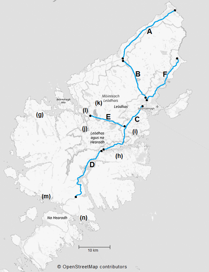
Figure 1: A map of Lewis & Harris showing numbers of recorded DVCs by road sections.
Click for a full description
A map of Lewis & Harris showing the number of recorded DVCs per year between 2023 and 2025 for specified sections of the A857, A858, A859 and B895 labelled ‘A’ to ‘F’, and for more generalised areas of more minor roads ‘g’ to ‘h’. The differing sections of A- and B-roads referred to in the report are highlighted in blue. Numbers of DVC reports are totalled by these sections of road as insufficient information on locations is available for most incident records to map them individually.
| Ref | Road Sections | Total | 2025 | 2024 | 2023 | Three- year average | Approx kms | DVC / yr / 10 km |
|---|---|---|---|---|---|---|---|---|
A | A857 Barvas - Ness | 23 | 9 | 11 | 3 | 7.7 | 21 | 11.0 |
B | A857 Barvas Moor (Newmarket - Barvas) | 18 | 9 | 4 | 5 | 6.0 | 16 | 11.3 |
C | A859 Lochs Road (Stornoway to Arivruaich) | 25 | 14 | 7 | 4 | 8.3 | 26 | 9.6 |
D | A859 Arivruaich Aline Woods - Clisham | 21 | 8 | 6 | 7 | 7.0 | 17 | 12.4 |
E | A858 Garynahine Achmore - A859 Junction | 13 | 5 | 4 | 4 | 4.3 | 13 | 10.0 |
F | B895 Newmarket Stornoway to Tolsta | 9 | 5 | 3 | 1 | 3.0 | 17 | 5.3 |
g | Minor road network in Uig area inc B8011 | 9 | 5 | 2 | 2 | 3.0 | - | - |
h | B8060 South Lochs to Tabost - Grabhair | 3 | 1 | 2 | 0 | 1.0 | - | - |
i | Minor roads nr Grimshader and Ranish | 3 | 2 | 1 | 0 | 1.0 | - | - |
j | Minor roads incl B8011 near Grimersta | 3 | 2 | 1 | 0 | 1.0 | - | - |
k | Pentland road (unclassified) Callanish to Carloway | 3 | 3 | 0 | 0 | 1.0 | - | - |
l | A858 Garynahine to Callanish | 1 | 1 | 0 | 0 | 0.3 | - | - |
m | B887 Bunavoneader to Amhuinnsuidhe | 1 | 0 | 1 | 0 | 0.3 | - | - |
n | Unclassified road Tarbet to Scalpay | 1 | 1 | 0 | 0 | 0.3 | - | - |
In each of the last three years, highest numbers of incidents have been recorded during October + November (see Figure 2 and Table 2). This late autumn peak coincides with the annual red deer rut (peak of the mating season) when red deer tend to be most mobile as they move from their spring / summer ranges to autumn / winter breeding ranges. In addition, it is also the period when daylight shortens most rapidly day to day, in the case of Lewis falling from eleven hours daylight in early October to just seven hours by end of November. The common occurrence of peak road traffic times at twilight or during hours of darkness inevitably increases risk of collisions with deer or other wildlife due to reduced visibility for drivers. Similar late autumn peaks in DVCs occurs in many other parts of Scotland where red deer are the only or predominant deer species present.
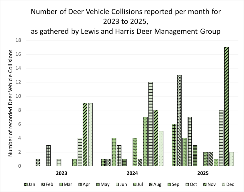
Figure 2: Bar graph of DVCs by month for each of three consecutive years
Click for a full description
The numbers of DVCs reported per month are shown on the Y-axis. Bars on the X-axis show data for individual months through each year 2023, 2024 and 2025. Distinctive combinations of patterns and background shading are used to indicate bars for the same calendar month in consecutive years. Note that some months had no DVCs.
A peak in numbers of DVCs recorded is apparent between September to December in each of the years. November is the month with the highest numbers of reports in two of the years (2023 and 2025) and second highest in the third (2024). A secondary inconsistent peak occurred in February, March or April in the different years, the most prominent one was in February 2025. June to August has been the period wit fewest DVC reports on Lewis & Harris.
| Month | 2023 | 2024 | 2025 |
|---|---|---|---|
| Jan | 0 | 1 | 6 |
| Feb | 1 | 1 | 13 |
| Mar | 0 | 4 | 4 |
| Apr | 3 | 3 | 7 |
| May | 0 | 1 | 3 |
| Jun | 1 | 0 | 0 |
| Jul | 0 | 4 | 2 |
| Aug | 0 | 1 | 2 |
| Sep | 1 | 7 | 1 |
| Oct | 4 | 12 | 8 |
| Nov | 9 | 8 | 17 |
| Dec | 9 | 5 | 2 |
Whilst a late autumn peak is apparent in all the last three years, the timing of that peak has tended to shift between the years. Figure 2 indicates an autumn rise in DVCs during 2023 starting in October and lasting through to December, in 2024 from September to December, but in 2025 restricted mostly to October and November. The few December instances in 2025 may be attributable to an extended period of heavy snowfalls reported by LHDMG, with consequently likely lower traffic levels and speeds.
Records for the timing and extent of a secondary late winter / spring peak remain rather variable across years at present. A very prominent peak did occur during February 2025, with also significant proportion in January and April. However, during both previous years, a much lower proportion of the annual total occurred between January to April.
The combined numbers of DVC reports for 2023 to 2025 available per month are re-summarised in Figure 3. This illustrates that over half of all DVCs were recorded during the three-month period from October to December. The period with fewest reported DVCs was from May to August, which coincides with the peak period of tourists visiting the Island. This suggest that in the case of Lewis & Harris, increased traffic due to tourism is unlikely to be a major factor influencing the rise in DVCs.
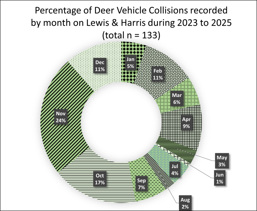
Figure 3: Doughnut graph showing the proportion of DVCs recorded in different months.
Click for a full description
The proportion of incidents recorded in different months is indicated by distinct patterns and labelled with the percentage recorded in each calendar month. The percentage of incidents in November and October are respectively threefold and twofold the proportion expected (8.33 %) if DVCs were evenly spread across all months. By contrast May, June, July and August each contribute only from 1% to 4% to the total of all incidents logged during 2023 to 2025.
Interestingly, the above pattern is in sharp contrast to the situation along the A851 on the Isle of Skye (S. Connolly, pers. comm.), where during their current DVC study and prevention campaign The British Deer Society has recorded highest rates of DVCs from May onwards through into summer; believed there to be mainly associated with the increased tourist traffic to and from the Armadale Ferry terminal.
Nighttime Thermal Survey A9
A comprehensive nighttime vehicle-based thermal scope survey covering most of the main road network of Lewis was undertaken over two nights at the end of March 2025 by a NatureScot wildlife management officer (WMO) assisted by one of NatureScot’s operations officers for Lewis & Harris. All the six road sections shown at the top of Table 1 were included in the March survey, totalling approximately 110 km. Two more limited follow-up thermal deer counts were undertaken between 21.00 hrs and 23.30 hrs on 14th and 15th October 2025. These were again led by the WMO, and accompanied by the DVC consultant, but covered only the A857 Stornoway to Ness and A859 Stornoway to Ath Linne (total length approximately 75 km).
The thermal-imaging scope used enabled detection and identification of medium to large mammals during darkness based on their heat signature at up to around 1000 metres from the road, provided no woodland or other dense cover nor fog obscured the views. Visibility for the surveys undertaken was generally good. Overall, the mostly open landscape of Lewis & Harris is well suited to such road-side survey. One main exception here are parts of Aline Woods, where visibility further than 50m from the road verge is obscured by tree cover.
During each survey, spotting and counting of animals was mostly undertaken by the passenger from within the vehicle whilst being driven at moderate speed, with occasional stops to scan over wider areas from laybys wherever safe parking was available. Further thermal surveys planned for one or more nights during the second visit in late November could not proceed due to severe stormy weather conditions.
Example images of deer as seen with the thermal scope are provided in Figure 4.a and 4.b
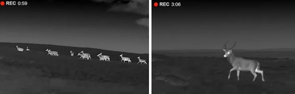
Figure 4.a and 4.b: Thermal scope images showing a herd of deer and a stag at night.
Results of the numbers of deer counted in the March and October thermal surveys along either side of the differing road sections are shown in Table 3. A total of 504 red deer were counted during the more comprehensive count during March 2025, and 177 during the partial count in October.
For deer counts along each of the longer road sections shown in Table 3 (see also Figure 1), the proportion seen within five sub-sections suggested as priority sites for site-specific mitigation measures (see ‘proposed mitigation strategy’), are also shown. These sites were selected as being of greatest priority on the combined basis of information from DVC records (Table 1), thermal deer counts (Table 3), speed limits, roadside habitats and other road conditions.
The locations of the five priority sites are shown in Figure 5
| Road Section | Total | of which within Priority Sites |
|---|---|---|
| A - A857 Barvas - Ness | - | Site I : High Borve - Galson - South Dell |
| March | 229 | 160 |
| October | 91 | 81 |
| B - A857 Barvas Moor (Stornoway - Barvas) | - | Site II : Barvas - N of Newmarket |
| March | 61 | 53 |
| October | 29 | 29 |
| C - A859 Lochs Road (Stornoway to Arivruaich) | - | Site III : Marybank Quarry – Loch Services |
| March | 65 | 33 |
| October | 22 | 20 |
| D - A859 Arivruaich - Aline Woods - Clisham | - | Site IV: Arivruaich - Aline Woods - Alh Linne |
| March | 43 | 41 |
| October | 35 | 35 |
| E - A858 Garynahine - Achmore and to A859 Junction | 0 | Site V : Achmore to Garynahine |
| March | 50 | 34 |
| October - No thermal count | - | - |
| F - B895 Newmarket (Stornoway) to Tolsta | - | - |
| March | 56 | - |
| October -No thermal count | - | - |
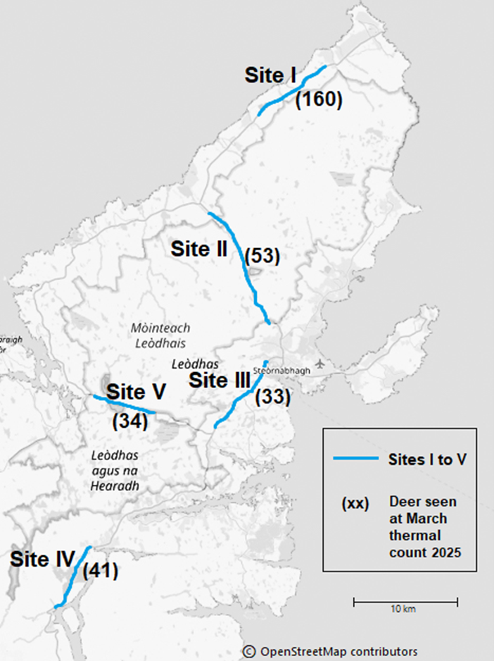
Figure 5: Map of Lewis & Harris showing the location of five priority sections of A-road between seven and 12 km in length, and the number of deer seen along each section.
Click for a full description
The location and approximate extent of each priority sites is highlighted in blue, starting from north with Site I and Site II (both within the A857), followed by Site III and IV along the A859 south of Stornoway, and Site V leading west along the A858.
Numerals in brackets show the number of deer seen along each section and reveal that in Site I more than threefold the number of deer (160) were seen from the road during the March 2025 thermal count than in any of the other sites.
Roadside camera trapping and dash-cam survey
Thermal surveys as above can be very useful in providing a snapshot of deer activity near the roadsides for one evening or night. To attempt to obtain additional information on deer behaviour at roadsides on the island throughout the day and night over a longer period, camera trapping (Figure 6) was undertaken over the period between the first site visit to Lewis in October and the second in late November. Three wildlife cameras were set up at three locations in mid-October (A857 near North Galson, A859 south of Stornoway near Loch Lathamul, and A859 near Aline Woods) and collected at end of the second field visit in late November. At each site, at least some recent deer hoof prints had been noted on nearby verges during day-time surveys. Having arranged necessary permissions with the roads department at Comhairle nan Eilean Siar, each camera was secured behind a road sign by mounting it on an existing signpost, so that the lens faced the direction of travel of the adjacent lane. To minimise false triggering of the camera by vehicles, the right half of the camera sensors was shielded using tape in each case, so that cameras would be activated only if an animal within a range of up to 25 metres moved onto the verge either from the left or after having crossed the road. All cameras were set to record 40 seconds of video at each trigger event.
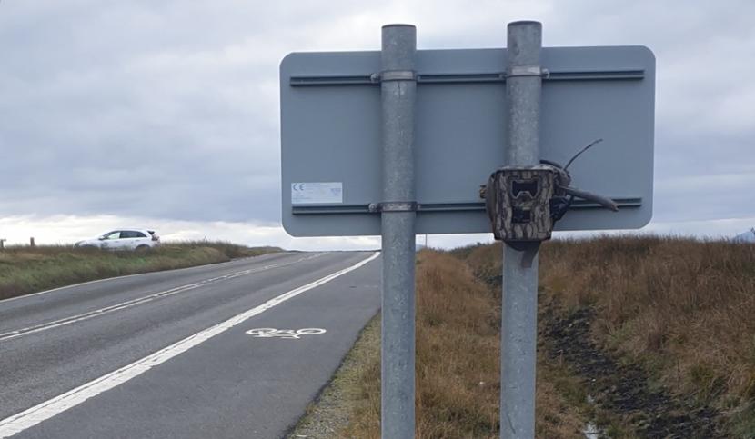
Figure 6: A camera trap in a metal housing secured to the back of a road sign.
Both cameras at the A859 functioned as intended throughout the seven-week period, with minimal false trigger events. The camera at A857 North Galson was, however, subject to numerous (400+) false trigger events, mainly resulting from buses and other high vehicles for which sensor shielding did not suffice.
Deer were captured on video crossing the road or grazing on the verges only at the A859 Aline woods site.
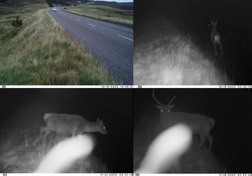
Figures 7a to 7d: A daylight view of the A859 and three night-time video frame captures of deer at the roadside.
At the Aline camera site, deer present within <25 metres triggered the camera 20 times (capturing nine separate occasions during six separate nights, when groups of one to three deer crossed the road or were filmed grazing on the verge for periods of one to eight minutes). All the deer on these camera trap recordings were detected during hours of darkness, between midnight and 04:30 hours. Example video stills are shown at (Figure 7 a-d).
Part of the aim of the camera trapping had been to observe how the deer reacted when vehicles were passing, as had been done previously by the author in other areas. Unfortunately, in this instance, all video recordings with deer in view occurred at various times during the night when no vehicles were present.
However, during drive-by surveys at night for the purpose of the thermal image counts in October, deer were seen present within less than five metres of the road on several occasions. In some of these instances, the deer remained calmly on the verge even when stopping the vehicle with the engine running within a few metres of them (see Figure 8). Deer were also seen crossing the roads calmly in front of the vehicle on one or more other occasions when driving along A859 through Aline Woods, A857 North Galson, A859 just south of Stornoway, as well as on several more minor roads.
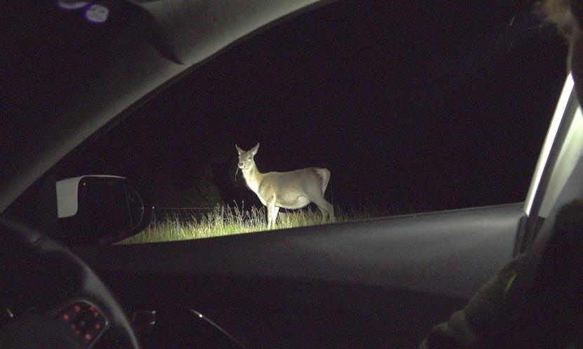
Figure 8: A red deer standing calmly on a verge lit up by vehicle headlights at night.
It had been planned to undertake a number of night-time dashcam surveys at selected sites during the last two nights of the November site visit, to record deer along the verges more directly. Unfortunately, although attempted for a short period on one-night, severe high winds and rainfall meant these had to be cancelled.
Day-time surveys and limited verge walk-over assessments
The primary aim of the field visits to Lewis & Harris was to view first-hand the road-sections of greatest concern, as well as to consult directly with members of the LHDMG, Comhairle nan Eilean Siar Roads Department, NatureScot’s local WMO and other island-based NatureScot personnel.
Initial day-time drives covering a large proportion, but not all of the roads of interest were undertaken during the two-day visit in October. Following that early familiarisation with some of the key sites, all the A-road network, as well as the B895 to Tolsta, and some of the island’s minor roads were driven over again by the consultant in daylight during late November. This was to gain a fuller impression of the extent of habitats, topography and road layout.
Videos of most routes were recorded on dashcam, to provide a log in case needed for later review in relation to proposals for potentially suitable mitigation measures.
For a few short road sections up to 1 km in length, walk-over surveys were undertaken along the road verges. Such walk-overs were kept to a minimum, as in many areas’ verges were on very uneven ground and often covered in dense tussocky grass. This made walking hazardous and inspections relatively unproductive, as hoof prints, runways or other signs of deer activity were unobtrusive in such terrain. Walk-overs included verges on either side of the roads within 500 m either side of the three trail camera locations (see above), as well as additional sample sections along roadside fencelines through Aline woods. At least some, but not very extensive deer slot marks and signs of animal trackways were noted near each of the trail camera locations.
Inspection walks along parts of the deer fencing near the A859 through Aline woods, showed extensive localised signs of deer activity on the verges between the road and deer fencing. In a number of areas, loose fencing or other gaps where deer could readily enter or leave the wood were noted, including at one of the main access gates (see Figure 9.b). Deer slots along both the inside and outside of the deer fencing were also clearly visible in several areas.
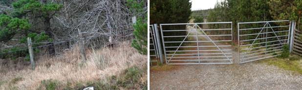
Figure 9.a and 9.b: A 1.4 m high fence with a loose line of barbed wire at the top, and a metal entrance gate with gaps wide enough for deer to pass through.
Local Consultation
Lewis and Harris DMG (LHDMG)
Prior to field visits to the island, contact was made with the current chair of Lewis and Harris DMG, who had been instrumental in raising the DVC issues with NatureScot’s WMO, and led on gathering of DVC records via landholders, local garages and other sources across the island.
To facilitate wider consultation with major landholding estates involved in deer management, it was agreed that the DVC consultant should attend the November 2025 meeting of LHDMG to outline the purpose of the study, highlight the potential effectives of differing mitigation measures used elsewhere, and present local information gathered to date. This also provided the opportunity for obtaining feedback directly from local estate managers. No hotspots additional to those previously identified based on past DVCs and the thermal survey were proposed. Most attendees agreed that whilst occasional DVCs had been an issue for many years, it was only over the last decade that they had become a common issue across much of Lewis. Those present at the meeting, being involved closely with deer and wildlife management themselves, were inevitable already aware of the risk of deer crossing the roads.
It was felt that many other island residents were less aware of the increase in deer numbers over the last decade. However, discussions also suggested that the increasing number of non-resident construction workers and delivery drivers may be those least familiar with the locations and times of greatest road crossing activity by deer.
Comhairle nan Eilean Siar
Initial contact was made also with staff at Comhairle nan Eilean Siar’s roads department in Stornoway prior to visits to the island, to consult them about plans for the proposed study. This including arranging permission to install wildlife monitoring cameras at some locations as part of the work, and plans for a more detailed face-to-face discussion of DVC issues during field visits to Lewis & Harris.
A meeting at Comhairle nan Eilean Siar was arranged for end of November, attended by the head of the Council’s roads department, the DVC consultant, NatureScot’s WMO and the Chair of LHDMG. Key points discussed included:
- Current DVC mitigation on the island is restricted to standard Department for Transport wild animals warning signage. Such signs are already present in many locations across the island, including most of the road sections highlighted elsewhere in the report where current DVC risk appears highest. All present agreed that, as elsewhere, a majority of drivers tend to habituate and take limited note of such signs.
- At present, use of digital signage in general across the island is restricted to Speed Indicator Devices (temporary, battery-operated LED signs that use radar to detect and display the speed of oncoming vehicles, aiming to reduce speeding in 20-40 mph zones). VMS signage, such as has been used as part of DVC mitigation by Transport Scotland on the mainland, is not currently available to the Council.
- Council staff were aware of only one killed or seriously injured casualty as result of a collision with deer in the last five years.
- It had been hoped to obtain fuller traffic data via the Council on diurnal traffic patterns for individual roads or sections of interest. Unfortunately, as a result of a significant cyber-attack that severely disrupted IT systems within the Council, these data were not readily available. (More basic information on Average Annual Daily Traffic [AADT] was therefore obtained via the DfT Road Traffic Count Points Map, which provide less detailed traffic counts, estimated in some cases from previous years).
In conclusion, all those present at the meeting agreed that in the short-term the most useful action would be to take steps to raise public and driver awareness of DVC issues on Lewis & Harris, highlighting the late autumn and winter period of the year and road sections where risk is currently believed to be greatest. It was suggested / proposed that this might best be taken forward initially via a press release by Comhairle nan Eilean Siar, in conjunction with NatureScot and LHDMG.
Discussion of Results
On the basis of findings from desk-top reviews and results of field visits, the key factors underlying the apparent rise in DVCs on Lewis & Harris over recent years appear to be:
- The increase in the island’s deer population over the past two decades, and in particular its spread and increase in density across Lewis rather than just Harris, where traditionally the vast majority of red deer had resided. Given the gradual nature of this change, public awareness of the true risk and its seasonal timing is likely to remain low, especially on Lewis.
- Presence of many long sections of very straight road, leading to traffic speeds often likely to be at or exceeding the 60-mph speed limit. Although forward visibility for drivers is mostly good, blind summits are present in numerous locations across the undulating landscape. These present a heightened risk not only from oncoming vehicles, but also deer out of sight on the road. Figure 10 [below] shows a view typical view of this along the A857 across Barvas Moor.
- Dense roadside vegetation only appears to be a significant factor for a minority of road sections affected by DVCs on the island; mainly restricted to the A859 through Aline woods. Some other areas (e.g. A858 near Garynahine; A857 near Newmarket) where woodland is present within 50 to 150 m on both sides of the road are also likely to have heightened deer crossing activity as the deer move between these areas of shelter, but here forward visibility for drivers is relatively good.
- The upward trend in deer numbers and wider spread of deer across Lewis over the past two decades coincides with a period when, by contrast, sheep numbers on the island have fallen quite dramatically. Thompson et al. (2024) reported that sheep numbers in the Outer Hebrides in 2021 (approximately.143k) were only 48% of what they were in 2000 (approximately.299k); declines recorded were largest in Harris (60% decline or approximately 34k head), and Lewis South (47% decline or approximately. 48k head). It seems likely that the lowered grazing pressure by sheep has been a factor contributing to an increase in deer utilisation of roadside vegetation and other areas of grazing near major roads formerly dominated by sheep.
- Numbers of DVCs recorded since greater efforts at recording DVCs began in 2023 (28) more than doubled by end of 2025 (65). It is likely that at least part of this recent increase in DVC reports is attributable to improved recording.
- The concurrent recent increase in heavy construction traffic on the roads, as well as extensive helicopter activity in connection with major ongoing infrastructure projects, could be an additional factor leading to greater levels of deer movements in general, including across roads. However, there is currently no direct evidence for any such effects.
Figure 10: An A-road through an undulating landscape with a wild animal warning sign and vehicular traffic in both directions.
Potential mitigation options
Based on the desk study and findings from field visits outlined above, the mitigation measures thought to have greatest potential for reduction of DVC risk on Lewis & Harris are outlined below, followed by a discussion of other measures and why those are not felt well suited in the local context.
When introducing any new measures of mitigation, careful consideration must be given not only to their likely effectiveness at reducing the risk of deer collisions at a given locality, but also to any potential inadvertent negative effects that may arise. For example, whether installation or upgrade of localised wildlife fencing could influence future deer movements across roads at another location; or how removal of scrub at a given roadside or an increase in pressure on deer through culling in one area may lead to them seeking out other areas in the vicinity of roads.
In making initial suggestions here for a potentially suitable mitigation strategy these and other factors have been taken into consideration. In the case of some measures (e.g. lead-in fencing for underpasses, or provision and positioning of new signage) further feasibility and road safety assessments are likely to be required, to decide whether specific measures can be included in the actual combination of approaches possible to take forward.
Previous reviews of mitigation measures suitable in differing contexts (Langbein et al., 2011) and more recently Putman & Langbein (2024) concluded that:
“In practice there will be very few situations where any one mitigation measure will be effective at leading to a significant and sustained reduction in collisions with deer or other animals when applied in isolation. Instead, in general, best results are likely to be achieved through use of a range of complementary measures, rather than reliance on any one individual approach”.
For example, traffic calming for dual carriageway slip roads or on a single carriageway A-roads, or seasonal use of VMS warnings, are likely to be more effective if supported by reducing scrub cover along verges, where relevant, to provide enhanced driver visibility and therefore longer breaking distances. Other reviews (e.g. Seiler et al., 2016, Huijser et al., 2021) also emphasise that “there is no single magic tool that prevents WVC [Wildlife Vehicle Collisions]; instead, prevention needs a combination of approaches that target differing factors on different scales”.
Mitigation measures suited to minor roads and single lane A-roads in general.
On Lewis & Harris no motorways nor dual carriageway roads are present. The great majority of DVCs are reported on single carriageway A-roads, with lower numbers on B-roads or other minor roads.
For single-carriageway A-class trunk roads and other more minor roads, including in urban as well as more rural areas, the recent review by Putman and Langbein (2024) suggests that in general combining a selection of the following measures is likely to be most appropriate:
- Verge maintenance to prevent scrub encroachment close to the carriageway to maintain good forward visibility for drivers to spot animals approaching the roadside and vice versa.
- Temporary deployment of mobile Variable Message Signs (VMS) to cover locally identified locations and peak months of past and predicted DVCs; or alternatively enhanced (digital) wildlife signage activated by Roadside Animal Detection Systems (RADS) for shorter high-risk sections.
- Use of digital speed activated signage, if RADS not considered appropriate or feasible locally. Whilst standard static wildlife warning signs have been shown to be of very limited effectiveness at reducing DVCs, digital speed activated versions may have some utility, even when combination with RADS is not feasible.
- Selective use of partial wildlife fencing to protect high risk sections and divert deer movements to safer crossing structures (existing bridges or underpasses) if available; or to areas with better visibility (e.g. deterring animals crossing at blind bends or summits). On roads of moderate traffic volume and speed, consideration could also be given to creation of dedicated deer ‘cross-walks’ directly over the carriageway, if supporting these by reduced speed limits and signage is deemed safe and feasible.
- Prevention of escalation of deer density close to roadsides. This may require a combination of habitat management to reduce deer settling in roadside cover or being attracted to good grazing near roadsides, as well as working with adjoining landholders to target higher stalking effort at these areas.
Raising public awareness of DVCs and their consequences among drivers and the local community.
Whilst in many areas of Scotland preventing woodland or scrub from encroaching onto road verges will be one of the primary DVC mitigation measures (see first bullet above), on Lewis & Harris such scrub encroachment causing poor visibility for drivers appears to be an issue in only a minority of DVC hotspot locations. However, each of the other measures listed above are worth consideration for at least some of the areas of the island where highest rates of DVCs have been reported.
A proposed DVC mitigation Strategy for Lewis & Harris
Information gathered during this project show that occurrence of DVCs is widespread across Lewis & Harris, with most non-urban roads on the island now carrying some risk of collisions with deer. In addition, five specific sections of A-road of elevated DVC risk have been identified, where targeting additional effort and available resources for mitigation measures is likely to be most cost-effective.
A strategy is outlined below, based on a) mitigation approaches for potential implementation at an island-wide scale, and b) additional variable site-specific combinations of mitigation measures for consideration at the five priority road sections.
The measures outlined span a spectrum from those that may be possible to implement in the short term to those that are more aspirational. Which measures can be implemented will be influenced by budgetary constraints and other competing road safety priorities. It is expected, therefore, that a phased approach is likely to be required. The island-wide measures may need to take priority in the short-term, reinforced later by additional site-specific actions at the hotspots highlighted or other high-risk locations, depending on the results of monitoring and future trends in DVCs.
Island-wide DVC mitigation measures
Although DVCs have occurred on the island for many years, in past decades they were reported (Seivwright, 2019) to occur predominantly on the A859 (between Tarbert to Loidse Ath Linne) and the A859 (Stornoway to Barvas). Given the gradual nature of the increase in deer numbers and distribution across all parts of Lewis & Harris, it is possible that among both locals and visitors’ awareness of the true risk of DVCs has lagged behind the increase in risk. The spread and then rise in numbers of red deer into new parts of the island, has inevitably also led to much greater management effort and resources being required to prevent further escalation of deer numbers.
The suggested primary island-wide measures considered appropriate for inclusion as the basis of a DVC risk reduction strategy for Lewis & Harris include:
Raising public awareness of DVCs among locals and visitors
A DVC public awareness campaign could include:
- press releases highlighting the widespread risk of DVCs throughout Lewis & Harris, naming also the highest risk road sections (i.e. A959 Aline Woods, A857 Galson to South Dell, A857 Barvas Moor, A869 Lochs Roads south of Stornoway, and A858 Achmore to Garynahine), and the peak DVC risk times (October to December, plus March; especially from dusk until dawn). Such press releases may have more impact if developed locally by, for example, Comhairle Nan Eilean Siar with support from others such as NatureScot, Police Scotland, Lewis and Harris DMG and Transport Scotland.
- sharing of press release information on local social media community groups and asking there for feedback including records of dates and locations of additional DVCs.
- promotion of DVC issues at relevant Caledonian MacBrayne ferry terminals. Caledonian MacBrayne are already engaged in DVC awareness raising work on Skye, where there is a focus on the spring DVC peak along the A851 between Armadale and Broadford.
- seasonal use of existing permanent VMS gantries on the Scottish mainland on approach roads to Western Isles ferry terminals (e.g. Caledonian MacBrayne owned signage along A87 on approach to Uig; Transport Scotland owned VMS on A835 approach to Ullapool) to display messages highlighting the heightened DVC risk on Lewis & Harris from October to December and in early spring.
Deer population management
Deer population numbers should be maintained within agreed bounds for the island as a whole, including giving particular attention to the need to avoid build-up of any high concentrations of deer in the vicinity of A-roads, as far as possible. Any deer management operations should be planned carefully, considering that high pressure on deer for extended periods in any one area could increase deer movements across roads in search of less disturbed areas.
Culling of deer in the immediate vicinity of roads presents specific challenges, and even where it can be undertaken safely it needs to consider carefully the potential for deer to run onto a carriageway. Aside from island-wide management of deer numbers, extra efforts directed at lowering deer numbers in the areas surrounding road sections with the highest DVC incidences could help avoid a further rise in DVC numbers. However, the relationship of deer densities and numbers of DVCs is rarely linear, and it should not be presumed that, for example, halving deer numbers would necessarily result in a proportional decrease in DVCs.
Consider DVC issues when planning new woodland or significant infrastructure
Except for Aline Community woodland, there are few areas on the island where woodland is present close to the main A-roads. However, with further woodland planting likely over the coming years, potential effects on increased DVC risk should be considered carefully when planning any new plantations, ideally keeping woodland boundaries 50 metres or even 100 metres from the verges of A-roads. Woodlands to either side of the A858 near Garynahine provide good examples where boundaries of substantial woodland areas have been kept well clear from the roadside, helping to maintain good visibility for drivers.
The impact of infrastructure projects on deer movements should be carefully considered as part of project planning and development, so that potential issues with deer moving across roads can be identified at an early stage, and appropriate mitigation measures implemented.
Combinations of potential site-specific mitigation measures
The five road sections below have been identified as of highest risk based on a combination of review of past DVC reports and the locations where the highest numbers of deer were recorded during night-time thermal image surveys during March and/or October 2025. The locations of the five priority sites are shown in Figure 5.
The site-specific combinations of measures suggested for each of these road-segments represent what would be considered optimal solutions in the absence of any budgetary or other constraints. In all cases, it is suggested that several of the measures outlined below, if not necessarily all, should be considered for implementation in combination. Nevertheless, for each, the measures proposed are as far as possible listed in order of priority.
One of the measures proposed for several of the sites below is temporary deployment of mobile VMS (with or without associated vehicle speed monitoring) during periods of highest DVC risk (likely focused mainly from early October through to early November). An example of similar signage deployed on the A9 near Navidale to highlight DVC risks in this manner is shown in Figure 11.
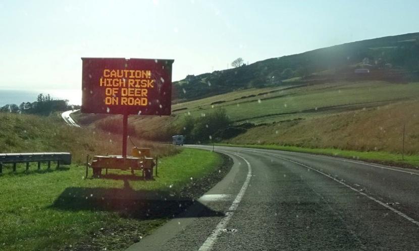
Figure 11: Example of a mobile variable message sign (VMS) deployed for a several weeks during early winter at the A9 near Navidale.
If resources can be sourced for just two or four such mobile signs, consideration could be given to deploying them for just a few weeks at a time at one or two of the hotspots, before then moving them to one of the other priority sites. Alternatively, VMS deployment could be focussed on two of the five sites in the first year, to help evaluate effectiveness of this measure in terms of changes in DVCs, traffic speeds (if also monitored), and public awareness. Although VMS use is included below as a potential measure for all five sites, priority should be given in the short-term to site ‘I’, plus either site ‘II’ or site ‘IV’).
- A857 High Borve - Galson - South Dell (7.5 km from approximately OS 141843,956992 to OS 148148,960907)
- Seasonal use of mobile VMS to alert drivers to heightened risk of deer. Approximate proposed locations for VMS deployment are indicated in Figure 14 (Annex 1). If temporary VMS signage is used, it is suggested that activation of messages be restricted to between sunset to sunrise, targeting the daily period when deer are generally most active near roadsides.
- Management of deer numbers at reduced levels in the vicinity of the road, including in the woodland area close to Melbost Borve, which is sought out by deer for shelter especially during the day and at times of inclement weather. In Site I, higher numbers of deer were seen close to the road in both the spring and autumn 2025 thermal counts than at any of the other sites (see Table 3). If herds of deer near the road cannot be reduced through landscape scale deer management, the option of more targeted, road-side deer control under a night-shooting authorisation may be appropriate.
- A standard Department of Transport ‘Wild animals likely to be in the road ahead’ warning sign is already present on the A857 northbound near Melbost Borve. Installation of additional, similar permanent signs should be considered on the southbound side by Loch Barabhat as well on northbound side before the blind summit approaching that loch.
- Mention of this site as a high-risk area in any DVC press.
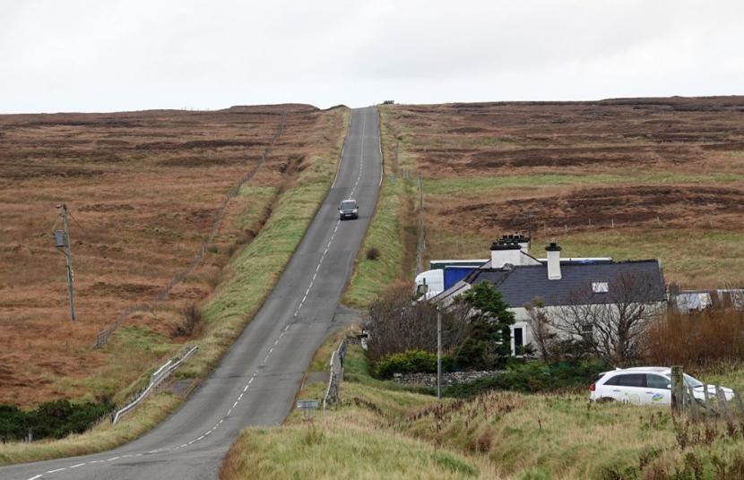
Figure 12: The A587 road running through an open, undulating landscape leading to a blind summit.
- A857 Barvas Moor (12.0 km from approximately OS 136535,948007 to OS 141265,937617)
- Seasonal use of mobile VMS to alert drivers to heightened risk of deer. Approximate proposed locations for VMS deployment are also indicated in Figure 15 (Annex 1). If temporary VMS signage is used, here too it is suggested that activation of messages be restricted to from around sunset to sunrise, to target the daily period when deer are generally most active near roadsides.
- Management of local deer numbers to prevent further rise in numbers.
- The A857 has an added risk factor due to the presence of several blind summits along mainly long and straight but undulating sections of road. ‘Blind summit’ signage is already present to warn of potential danger at several hill crests that hide oncoming traffic. Consideration could be given here to further reinforce this messaging, by installing additional ‘Wild animals likely to be in the road ahead’ warning signs directly alongside the blind summit sign locations across Barvas Moor, to alert drivers of the additional potential hazard of deer in the middle of the road on the ‘blind’ side of these summits.
- Mention of this site as a high-risk area in any DVC press releases.

Figure 13: One of several locations with existing blind summit signage along the A857.
A858 Lochs Road Marybank Quarry – Loch Services (7.5 km from approximately OS 140582,932982 to OS 135752,927889)
This area on the southern edge of Stornoway has several woodland blocks to either side of the road, leading to increased deer crossings as they move between these areas on a daily or seasonal basis. Mitigation measures proposed include:
- Seasonal use of mobile VMS to alert drivers to heightened risk of deer. Approximate proposed locations for VMS deployment are also indicated in Figure 16 (Annex 1). If temporary VMS signage is used, here too it is suggested that activation of messages be restricted to from around sunset to sunrise, to target the daily period when deer are generally most active near roadsides.
- Management of local deer numbers to prevent further rise in numbers.
Mention of this site as a high-risk area in any DVC press releases.
- A859 Aline Woods Arivruaich to Ath Linne (8.0 km from approximately OS 124689,917514 to OS 119729,911979)
Investigate the possibility of using part of this area (through Aline Woods) as a NatureScot/Transport Scotland trial site for installation of a RADS1 through those sections where woodland is present on one or both sides (see Figure 17 (Annex 1), as previously suggested also on A9 near Helmsdale. [The location of this site appears very well suited to such a system, with verges of sufficient width where deer are frequently present particularly during the night.]
Or:
- Seasonal use of mobile VMS to alert drivers to heightened risk of deer. Approximate proposed locations for VMS deployment are also indicated in Figure 17. If temporary VMS signage is used, here too it is suggested that activation of messages be restricted to between sunset to sunrise, to target the daily period when deer are generally most active near roadsides.
- Inspect existing deer fencing and repair any unintended gaps. The deer fencing does not currently prevent access of deer into Aline wood plantations, within which deer are regularly present. As such, the fence merely limits to some extent where direct movement of deer from the wood onto the verge and vice versa is possible.
- Management of local deer numbers to prevent further rise in numbers.
Mention of this site as a high-risk area in any DVC press releases.
- A858 Achmore to Garynahine (7.0 km from approximately OS 130184,929629 to 123874,931799)
- Management of local deer numbers to prevent further rise in numbers.
- Mention of this site as a high-risk area in any DVC press releases.
Consider seasonal use of mobile VMS to alert drivers to heightened risk of deer if found effective at the other high-risk sites. Approximate proposed locations for VMS deployment if used are indicated in Figure 18 (Annex 1). If temporary VMS signage is used, here too it is suggested that activation of messages be restricted to between sunset to sunrise, to target the daily period when deer are generally most active near roadsides.
The location and extent of each of the five highest risk sites I to V are given in more detail in map Figures 14 to 18 (Annex 1), showing also approximate proposed locations for potential application of VMS (or RADS in case of Site IV) if used. In each case, use of VMS or RADS should be in combination with other measures outlined above, including active management of deer numbers on the land bordering each of the sites.
Other measures not thought suitable for the selected locations
Other mitigation measures that have not been included among the measures outlined as part of the above mitigation strategy and brief reasons as to why they are considered unsuitable, are outlined below.
In their recent review of DVC mitigation measures and their potential effectiveness Putman and Langbein (2024) distinguished the main categories of measures that tend to be most suitable for motorways and other major roads of high traffic flow, others suitable for roads of moderate or low traffic volumes, and those not likely to be effective at all.
The suggestions in the previous section for combinations of measures that may be suitable for specific road sections considered in this report, are primarily drawn from measures that in Tables 2 and 3 of the earlier review were considered a) suitable for roads of low to moderate traffic flow b) to have at least medium to high potential levels of effectiveness, as well as c) appropriate for further consideration at the selected sites in question.
There are nevertheless also other mitigation measures that might be thought useful in similar situations, and these are listed below with a brief reasoning as to why they were not included for use on Lewis & Harris.
Roadside wildlife deterrents: Multiple differing light-reflecting as well as actively signalling light and audio devices claiming to deter deer from crossing roads while traffic is present are available on the market. None to date have proven lasting effectiveness even on roads of relatively low traffic flow. During night-time surveys on Lewis & Harris deer were present on the road verges, on several occasions within 10 metres, and they did not leave even when stopping a vehicle at the side of the road with the engine running and headlights left on. Similarly, chemical roadside deterrents, even where they have shown a deterrent effect on deer, at best tend to result in deer crossing in another location further along the road.
2. Roadside fencing: The only area where wood or scrub is present close to the road in an area of high DVC risk on the island is on the A859 through Aline Woods. In parts of this route where the wood is within 10 to 20 metres of the road, a deer ‘deterrent’ fence is already present, though it is not deer-proof including due to various gaps within and beneath. Extension of this fencing throughout that high-risk section (see Figure 17 for Site IV above) is not currently recommended, as it could lead to extra issues resulting from deer being trapped within a road corridor several km in length. This would then require provision of exit deer-leaps from the verge into the wood, to enable deer that do enter the corridor to escape from the roadside. Therefore, maintenance to repair any holes and other unintended gaps in the existing shorter stretches of fences, rather than extension of fencelines, is recommended.
3. Leading deer to safer passages: Using short lengths of fencing to lead deer to cross using safer passages can be very useful in some situations, but no good opportunities for this existed at any of the sites inspected. One location considered was a stream underpass beneath the A857 within Site I. However, although in principle high enough for deer to pass through, the lack of any ledge either side of the stream would make passage by deer only likely when water levels were very low.
4. Speed reduction: The feasibility of using permanent speed reductions as part of DVC mitigation for the main roads on Lewis & Harris is likely to be limited. The speed limit for most of the A-roads on the island, whilst set at the national limit of 60 mph in areas without housing, is already limited to 40 mph or lower for numerous sections where the roads pass through small villages, even those with very few houses. Motorists often drive to the conditions in front of them, and if the road looks and feels to them as though it should have a higher speed limit, they will get frustrated with a requirement to travel more slowly if there is no obvious reason for the reduced speed limit. Rather than varying speed limits, strategic use of temporary mobile VMS at times of the year when deer crossing activity is greatest is suggested for increasing awareness of heightened DVC risk among road users. The start and end points of high-risk sections for the priority sites (see Figures 14 to 18) have in most cases been located where the speed limit is currently 60 mph, rather than including any areas where it is already set at 40 mph.
5. RADS: With exception of possibly a trial at Aline Woods (see Site IV), Roadside Animal Detection Systems are not at present suggested as suitable for any of the other sites. This is partly because currently detail on past collision locations is lacking and it is not possible with any confidence to identify hotspots to within less than 5 km.
Monitoring the effectiveness of a DVC strategy
A key aspect of the suggested approach to mitigation at each of the specific sites considered, which is also likely to apply to DVC mitigation in most other areas, is that several complimentary measures should be used in combination rather than reliance on any one individual measure. One downside of such combined strategies is that assessment of the extent to which any future changes in DVC frequency are attributable to any individual measure will be more difficult at a site level; although insights on the contribution of a particular measures may be gained from comparing between sites, where a given measure is included or not. In terms of monitoring, the main emphasis may therefore need to be mostly on assessing whether significant changes in DVCs can be attributed to the overall strategy, rather than changes in other external factors (such as increased/reduced traffic volumes, (uncertain) fluctuations in deer population size year to year, or variability in DVCs considered over too few years). To assist with more direct evaluation of differing measures such as VMS, whilst taking parallel potential changes in deer numbers fully into account, consideration could be given to selective annual drone counts along roadsides of the high-risk areas as outlined further below. These and other general suggestions for monitoring effectiveness of individual measures and the overall strategy are summarised below. Any specific monitoring schemes put in place would clearly need to be adapted based on local conditions and which specific measures, if any, can be implemented in practice.
For monitoring the effectiveness of the DVC strategy adopted overall and at each of the highest risk sites, consider the following:
- Before and after monitoring of DVC reports within a defined distance in as consistent a manner year to year as possible. Locally, gathering DVC information by Lewis and Harris DMG started only three years ago, with some of the increases in the latest two years possibly attributable to further improvements in recording. For the time being it may be best to use the average of DVCs reported 2024 + 2025 as the baseline, against which DVCs recorded post implementation of differing measures taken forward are evaluated. The locations of reported DVC incidents should be recorded with greater precision in future whenever possible, allocation of each incident at least to within a 5 x 5 km grid or even 1 x 1 km when information provided allows.
- In addition to maintaining the current DVC data gathering via the DMG, we would suggest consideration be given to obtaining extra information a) via social media community groups for island residents to report any DVCs they are involved in, and b) via the island tourism association to contact all providers of Hotels, B&Bs, and self-catering outlets, to encourage tourists to report DVCs. (The latter is suggested partly as those tourists / visitors who bring vehicles to the island and sustain some but only minor, non-urgent damage to vehicles through DVCs, are unlikely to use local garages for repairs; these garages being the major source of current DVC information to the DMG)
- Roadside thermal imaging surveys undertaken by / with NatureScot staff produced very useful insights for the present project. To improve precision and efficiency of such roadside deer counts, consideration should be given to undertaking targeted annual roadside surveys by drone at a set time after dusk covering a set cordon (of e.g. 500 - 750 m) along each side of the road) for either a selection or all five of the five high-risk areas only. This could provide excellent consistent data on true changes in deer presence and density in vicinity of the roads in question, against which changes as a result of mitigation measures implemented may be evaluated objectively. At present, the best available figures on deer density and distribution are those from the latest (2022) island-wide helicopter counts via NatureScot. However, these counts are generally only repeated approximately once every eight to 10 years across the Highlands and Island on a rolling basis. A selective sample of road-based drone counts for the primary purpose of monitoring effectiveness of DVC mitigation, could provide also valuable interim sample data on year-to-year changes in localised deer densities in relation to direct deer management measures undertaken locally, before the next further island-wide helicopter count is due. The mostly open lowland landscape of Lewis seems very well suited to such selective roadside survey by drone.
- Collation and review of information on any deer control measures undertaken overall and broken down by each Community Trust and or large estates that border the five priority sites in the different areas. Year to year evaluation of additional stalking effort within the areas bisected by the priority DVC sites will help in assessing its effectiveness and in identifying potential changes in the distribution of DVC hotspots.
- Where mobile VMS deer warnings can be displayed seasonally, parallel assessment of changes in average traffic speed can be useful as an indicator of changes in driver behaviour. However, the aim of the suggested signage in this context is raising driver awareness of the increased risk of deer presence, rather than necessarily speed reduction per se. Therefore, while recording of vehicle speeds (between sunset and sunrise) before, during and after periods of VMS use could be useful, the findings from such work will not necessarily correlate directly to a change in the risk of a DVC occurring.
- If a trial of RADS is taken forward, monitoring of its impact should ideally include a plan for roadside video monitoring of actual deer and other wildlife activity along the trial section of road. This will allow validation of the numbers of times sensors detect wildlife against the frequency that networked digital signage is activated. Changes in driver speed at times when signage indicates presence of wildlife could also be assessed.
- In addition, where RADS or VMS are used, comparative monitoring should, if possible, be replicated and assessed against one or more control sites (e.g. from among the other priority sites) to help assess their actual effectiveness.
Conclusions
Background
NatureScot and Transport Scotland together previously commissioned a report (Putman and Langbein, 2024) that reviewed available deer-vehicle collision (DVC) mitigation measures at an international scale, including their costs and effectiveness in various situations. The review discussed the merits, limitations, and potential negative effects of more than twenty major measures and numerous further sub-categories and types of measures within each. With such an array of measures, selecting the most appropriate mitigation for any given scheme is challenging for road safety teams (aiming to reduce risk to road users) and conservationists (concerned about roadkill and animal welfare) alike, not least as the costs of measures vary greatly and their effectiveness in specific situations is often uncertain.
A key conclusion arising from the 2024 review, as well an earlier mitigation review (Langbein et al., 2011) is that, in practice, there will be very few situations where any one mitigation measure will be effective at leading to a significant and sustained reduction in collisions between vehicles and deer or other animals when applied in isolation. Instead, in general, best results are likely to be achieved through use of a range of complementary measures, designed to suit the particular circumstances of the relevant location.
Following on from the above review, two previous site-specific studies considered suitable mitigation options for three major trunk road interchanges in Central Scotland that had previously been identified as DVC hotspots on the M8 and M9 motorways and A82 (dual), and a section of single-lane trunk road (A9) near Helmsdale in East Sutherland with high levels of DVCs over recent years. This study aimed to identify suitable mitigation options for various parts of the A- and minor-road network on Lewis & Harris, for potential implementation at some specific sites on the island and provide insights that might be transferable to other comparable non-trunk road locations elsewhere on the Scottish road network.
Assessments included reviews of the scale, seasonality, and distribution of past DVC records, as well as two field visits to Lewis & Harris to view much of its main road network and gain an understanding of the local road environment, habitat availability, and deer activity.
Devising Mitigation strategies
The principle of applying a combination of measures might be compared to devising a medical treatment plan, which will usually involve an initial diagnosis of symptoms, physical examination, health advice, medication and, if appropriate and proportionate to the issues, direct physical intervention. Taking this analogy further, measures taken will rarely provide complete solutions, and many actions taken may also have foreseeable or unknown side effects. It is therefore crucial to have realistic expectations, monitor effectiveness, and adapt plans accordingly.
In a meta-analysis using data from 50 studies that quantified the relationship between wildlife roadkill and a mitigation measure designed to reduce roadkill, Rytwinski et al. (2016) found that, overall, mitigation measures reduced roadkill by 40% compared to controls. They also concluded that comparatively expensive mitigation measures tend to reduce large mammal roadkill much more than inexpensive measures. Combinations of fencing and safe crossing structures (bridges or underpasses) led to an 83% reduction in roadkill of large mammals. Overall, fences with or without crossing structures averaged 54% reductions, compared to a 57% reduction for animal detection systems, and only a 1% reduction for wildlife reflectors.
Based on the above, relatively inexpensive wildlife reflectors or other roadside deer deterrents, most of which have no proven or at best very short-term effects, might be compared to a sticking plaster. On the other hand, provision of high wildlife fences for long sections on both sides of the road, that also lead animals to suitable alternative safe passage at regular intervals might be thought of as the ‘gold-standard’. However, even in the limited situations where the high cost associated with installation and maintenance of long lengths of deer fencing can be justified, and such mitigation is also acceptable in terms of landscape considerations, potential side effects may require additional mitigation measures. In areas with high potential for bird strikes (particularly with capercaillie or other grouse species), for example, the installation of fence strike markers may be necessary, or if deer fencing is provided on both sides of the road, deer-leaps may need to be installed to allow deer that do manage to access the road corridor to escape from the roadway.
At present, information on actual effectiveness of measures aimed at raising driver awareness of the risk of deer on roads remains limited. Most studies into the effectiveness of standard static wildlife warning signs in reducing collisions with deer conclude that they are ineffective (e.g. Meyer, 2006; Bullock et al., 2011). However, research by Hardy et al. (2006) in Montana, showed that wildlife advisory messages posted on permanent and mobile VMS were generally effective in reducing average motorist speeds. Their results also suggested that the advisory messages are more effective at reducing speeds during dark conditions. Furthermore, Hardy et al. found that messages on the mobile VMS had a more significant impact on average speed than the messages on the permanent VMS. Less is known so far about the effectiveness of more general public awareness campaigns, such as used on the Scottish mainland, during the season(s) when the risk of deer crossing roads is highest.
In most road-based scenarios, however, use of several measures that help to reinforce each other are likely to be appropriate. For example, seasonal VMS deer signage, are themselves likely to be more effective at reducing risk of collisions with wildlife if supported by wider publicity, as well as parallel efforts to contain further increases in, or reduce, local deer numbers.
Island-wide and Site-specific Combinations of Measures
On Lewis & Harris, DVCs have become very widespread, with most non-urban roads on the island now carrying some risk of collisions with deer. Five road-sections five to 10 km in length were identified where DVC risk appears highest and where targeting additional mitigation effort is likely to be most effective. The mitigation strategy proposed, includes a number of measures for potential implementation at an island-wide scale, together with additional site-specific measures for the five road sections considered of highest priority.
Island-wide options suggested focus on raising public awareness among both residents and visitors, via measures including (seasonal) press releases, use of social media and ‘buy-in’ from Caledonian MacBrayne Ferries, as well as deer management planning via LHDMG to help maintain overall deer numbers at appropriate levels. Potential site-specific measures for the higher risk areas focus on use of mobile VMS at times of the year when DVCs peak locally (October to December, and March), combined with deer management planning to reduce localised aggregations of deer near those road sections. Budgetary constraints may limit implementation to just one or two sites initially before rolling out to or alternating with the other sites over time. The possibility of using one of the sites (Aline Woods) as a trial-site for a novel RADS to warn drivers when deer are present on the verge, should be investigated.
Transferability
Some elements from the overall approach taken during the present assessments and mitigation measures proposed may well be transferable to other comparable areas with also relatively high levels of DVC occurrence on A-roads and minor roads of relatively low or moderate traffic volume. Possibly the most closely comparable situations to Lewis & Harris may occur on other Scottish Islands, such as Mull and Arran, with similarly high numbers of red deer and known DVC issues. Other not dissimilar situations will, however, also be widespread in other parts of the Scottish mainland. Interestingly, by contrast to the late autumn peak in DVCs on Lewis & Harris, along the A851 on Skye, where some parallel DVC mitigation campaigns have been initiated by the British Deer Society, the seasonal peak of DVCs occurs in late spring and summer, coinciding with peak occurrence of tourist traffic. This underlines again the importance of site-specific evaluation and planning of mitigation measures.
Importance of continued Monitoring
A significant challenge affecting the choice of mitigation options is that for many measures detailed studies of their true effectiveness are lacking, or else not available in the context of comparable site conditions. Studies necessary for objective assessment require comprehensive and directly comparable series of data both ‘Before and After’ installation of mitigation, ideally including records not only of annual levels of DVC incident reports but also changes in local deer population numbers and management.
In many areas of the mainland, the longstanding NatureScot and Transport Scotland DVC collation project, which since 2008 has collected comparable information on reported deer collisions, can provide helpful background information. On Lewis & Harris, good records on DVCs have only started to be drawn together since 2023. In order to evaluate the effectiveness of any mitigation measures that are implemented, it will be important to continue to gather DVC reports throughout the island in a consistent manner and to strive to obtain more precise details of locations and times of as high a proportion of incidents as possible. Better detail on DVC locations to enable accurate mapping will also assist with including all records into the National NatureScot DVC database.
Monitoring of mitigation should not, however, be restricted to assessing DVC records. For measures aimed at raising driver awareness, monitoring could include assessments of resulting changes in average traffic speed. In addition, questionnaire type surveys among residents and visitors to the island, replicated two or more years apart, could help assess the effectiveness of public awareness campaigns undertaken.
References
Department for Transport (2023) Road Traffic Statistics.
Bullock, K.L., Malan, G. and Pretorius, M.D. (2011) Mammal and bird road mortalities on the Upington to Twee Rivieren main road in the southern Kalahari, South Africa. African Zoology 46, 60-71.
Finlay, J. (1984) Faunal Evidence for prehistoric economy and settlement in the Outer Hebrides to 400AD, unpublished PhD thesis, Edinburgh University.
Hardy, A., Lee, S. and Al-Kaisy,A.F. (2006) Effectiveness of animal advisory messages on dynamic message signs as a speed reduction tool. Transportation Research Record 1973, 64-72.
Huijser, M.P., Ament, R.J., Bell, M., Clevenger, A.P., Fairbank, E.R., Gunson, K.E. and McGuire, T. (2021) Animal Vehicle Collision Reduction and Habitat Connectivity – Literature Review. Report 701-18-803 TO 1 to the Nevada Department of Transportation, Carson City, NV 89712.
Langbein, J. and Putman, R.J. (2006). National Deer-Vehicle Collisions Project: Scotland, 2003-2005. Report to the Scottish Executive, June 2006.
Langbein. J. (2011) Deer Vehicle Collisions in Scotland Monitoring Project 2008-2011: Final Report to Scottish Natural Heritage. Deer Initiative Research Report 11/2.
Langbein, J., Putman, R.J. and Pokorny, B. (2011) Road traffic accidents involving ungulates and available measures for mitigation. In: Ungulate Management in Langbein 2017 DVC Scotland
Langbein, J. (2019) Deer Vehicle Collisions (DVC) data collection and analysis 2016 - 2018. Final Report to Scottish Natural Heritage. Scottish Natural Heritage Research Report No. 1158.
Langbein, J., 2025. Deer Vehicle Collisions - a review of mitigation measures and their effectiveness - applying the findings at a site-specific scale. NatureScot Research Report 1381.
LHDMG (2019) Lewis and Harris Deer Management Group Annual Report - Year to 31 March 2019 (online)
Lush, M.J. and Lush, C.E. (2023) Deer Vehicle Collision analysis 2019-2021. NatureScot Research Report 1329.
Lush, M.J. and Lush, C.E. (2026) Deer Vehicle Collision Analysis 2022–2024. NatureScot Research Report 1400.
Meyer, E. (2006) Assessing the effectiveness of deer warning signs. Final report. Report no. K-TRAN: KU-03-6. The University of Kansas, Lawrence, Kansas, USA.
Mulville, J. (2010) Red Deer on Scottish Islands. In ‘Extinctions and Invasions: A Social History of British Fauna. O’Connor, T. and N. Sykes.
Putman, R.J. and Langbein, J. (2024). Deer Vehicle Collisions - a review of mitigation measures and their effectiveness. NatureScot Research Report 1354
Rytwinski T, Soanes K, Jaeger, J.A.G., Fahrig, L., Findlay, C.S., Houlahan, J. (2016) How Effective Is Road Mitigation at Reducing RoadKill? A Meta-Analysis. PLoS ONE 11(11): e0166941. DOI: 10.1371/journal.pone.0166941
Seiler, A., Olsson, M., Rosell, C. and van der Grift, E. (2016) Cost-benefit analyses for wildlife and traffic safety. CEDR Transnational Road Research Programme Call 2013: Roads and Wildlife Technical report No. 4
Seivwright, L. (2018) Lewis and Harris Deer Management Group Part 1: Deer Management Plan Information & Public Interest Actions. Lewis and Harris DMG. (online)
Stanton, D., Mulville, J. and Bruford, M. 2016. Colonization of the Scottish islands via long-distance Neolithic transport of red deer (Cervus elaphus). Proceedings of the Royal Society B: Biological Sciences 283 (1828) 20160095. 10.1098/rspb.2016.0095
Thomson, S., Pirie, S., Atterton, J., Moxey, A., Sellars, A., Chapman, P., Nelson, B., Naab, F., Jamwal-Fraser, O., MacMillan, I, McCracken, D., Sutherland, J., Macdonald, S., Stevens, J., and Glendinning, J., (2024) Rural and Agricultural Development – Maximising the Potential in the Islands of Orkney, Shetland & Outer Hebrides. A SRUC report to Orkney Islands Council, Shetland Islands Council, Comhairle nan Eilean Siar, Orkney Local Action Group, Shetland Local Action Group, Outer Hebrides Local Action Group, and Highlands and Islands Enterprise. Trends in Agriculture Chapter 6
Transport Scotland (2020). Scottish Transport Statistics No. 39-2020 edition. Chapter 4: Road Network.
Transport Scotland (2024) Transport Scotland web-site: The trunk road network.
Annex 1 – Additional Map Figures
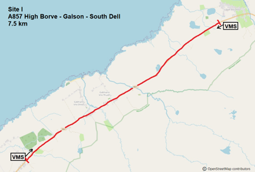
Figure 14: Map showing the approximately 7.5 km extent of Site I along the A857.
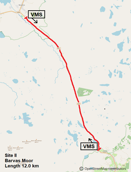
Figure 15: Map show the approximately 12 km extent of Site II along the A857.
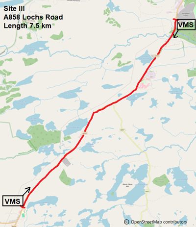
Figure 16: Map show the approximately 7.5 km extent of Site I along the A859.
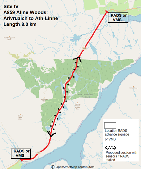
Figure 17: Map show the approximately 8.0 km extent of Site IV along the A859.
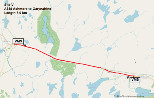
Figure 18: Map show the approximately 7.0 km extent of Site V along the A858.