Maerl beds
Improving the protection given to Priority Marine Features
Priority Marine Feature - maerl beds
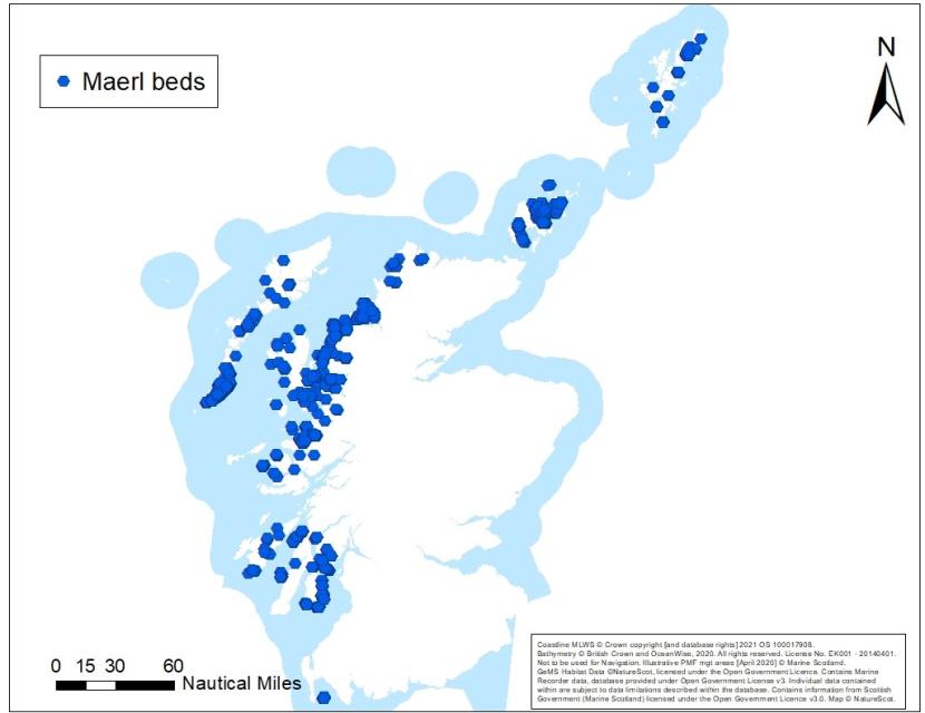
An overview of maerl bed records
Description
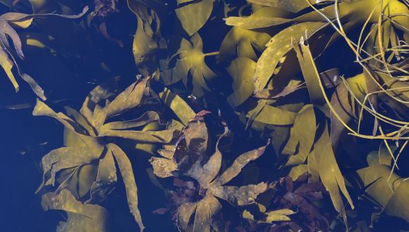
Characteristics - Maerl beds are formed by unusual red seaweeds with hard chalky skeletons that grow in different forms, either as small, rounded nodules or short, branched twig-like shapes (sometimes termed ‘thalli’ or ‘rhodoliths’). At high abundance, these nodules and twigs form loosely interlocking carpets through which seawater is able to circulate. This creates perfect conditions for the development of diverse communities of plants and animals on, between and under the pieces of maerl. Maerl needs light to grow, so living maerl beds are restricted to water generally shallower than 25 m, though in exceptionally clear waters they can extend down to 38 m depth. Living maerl is restricted to the surface layer of the beds, overlying the chalky skeletons of dead maerl. At least three maerl species exist in the British Isles and the relative composition of these within a bed, and the proportion of living / dead maerl within and between beds, varies with factors such as salinity and wave exposure. Maerl beds are extremely slow growing and extensive beds may be 1000s of years old. Most of the maerl beds in the UK lie along the fjordic coastline of western Scotland which has more records than any other European country (OSPAR, 2010).
Definition - Maerl beds are defined by the presence of a complex 3D structure, created by accumulations of maerl pieces. Depending on environmental conditions, beds can form as continuous carpets, patches of dense maerl on other sediments, or have a linear appearance, following the troughs or ridges of sediment waves on the seabed.
Accumulations of maerl are considered a bed where there is at least 20% coverage of dead or live maerl thalli. The 20% cover of maerl substrates has to extend over an area of at least 5 m x 5 m (25 m2 - whether continuous or in discrete patches / rows). Areas of the seabed where the substrate is made up of broken maerl gravel may also be considered maerl beds, albeit degraded ones, when there is at least 5% cover of live maerl material >1 cm in size. This latter part of the definition only applies in areas where maerl habitats are known to have been impacted and where management action is envisaged. No maerl beds (or ‘degraded maerl beds’) have been identified for protection as part of the current review on the basis of this part of the definition with the exception of the Clyde, where maerl habitats are generally severly degraded and it is recommended that all remaining beds require protection to support PMF recovery and increase resilience.
Environmental preferences - Maerl beds develop on coarse clean sands and gravels either at the open coast or in tide-swept channels to a depth of about 25 m. Occasional records from muddier sediments e.g. Loch Torridon and in deeper waters e.g. Shetland.
Distribution
Scottish distribution - Maerl beds are widespread on the west coast, ranging from Luce Bay, Arran and the Clyde, around Gigha, Jura, along the west coast from Mull northwards, around the Small Isles and Skye, the Inner Sound, the Outer Hebrides, Loch Eriboll, Orkney and Shetland. There are no known examples on the east coast although sparse maerl thalli have been recorded at locations off the north-east coast (e.g. in the outer Moray Firth off Buckie; see Moore, 2017).
Estimated known Scottish extent - Maerl beds vary considerably in size and the extent to which they are connected. Some beds are isolated and distinct, such as the small 0.1 ha bed at North Strome in Loch Carron (Moore et al., 2018). Other locations support numerous maerl beds extending over many square kilometres, e.g. in nearshore waters around Orkney.
Wider distribution - Recorded from south-west England, Wales, Ireland and Northern Ireland, north-west Iceland, north-west France, north-west Spain and the Canary Islands. Also known to occur in Sweden and Norway.
Status
Maerl beds have a globally restricted distribution. Scottish waters support approximately 30% of the maerl beds in north-west Europe and most of the beds in the UK. The habitat is listed as threatened and / or declining by OSPAR (OSPAR, 2008), with evidence of decline in both extent and quality across the Celtic Seas, OSPAR Region III (Hall-Spencer et al., 2010). This feature can be part of the broadscale habitats protected in Special Areas of Conservation (SACs): Sandbanks which are slightly covered by sea water all the time; and, Large shallow inlets and bays under Annex 1 of the EU Habitats Directive (European Commission, 2013). The Directive is transposed into domestic legislation through The Conservation (Natural Habitats, &c.) Regulations 1994 (as amended in Scotland) (Habitats Regulations).
Evidence of deterioration in the condition of maerl beds in the Wester Ross MPA, South Arran MPA and Sound of Barra SAC have led to a ‘recover’/’restore’ conservation objective being set for the feature at these sites.
Drivers for improving protection
Maerl beds are included on the PMF list which means that National Marine Plan General Policy 9(b) (avoiding significant impact on national status) applies. Maerl beds are an OSPAR threatened and deciling habitat in need of protection. The Scottish Biodiversity Strategy to 2045, the Scottish Biodiversity Duty and UK Marine Strategy Good Environmental Status provide further drivers to ensure biological diversity is restored, and ecosystems are safeguarded.
Sensitivity (including recovery)
[Key sources: FeAST, Fisheries Management Guidance]
Maerl beds are highly sensitive to physical disturbance, particularly in the form of abrasion and habitat removal / change, organic enrichment, siltation and changes in water flow (Hall-Spencer & Moore, 2000; Perry & Tyler-Walters, 2018). Activities associated with these pressures include bottom-contacting fishing, aquaculture (Hall-Spencer et al., 2006) and coastal development (Mazik et al., 2015).
Maerl beds may also be vulnerable to future climate impacts associated with sea temperature rise, marine heatwaves, ocean acidification, changes in salinity and increased storminess, with likely knock-on effects on community composition and function (Birchenough et al., 2013; Martin & Hall-Spencer, 2017). Changes in circulation, oxygenation, salinity, increased run-off and increased storminess may also have an impact. An MCCIP (2018) paper concluded that reducing pressures associated with human activities remains the most effective method of increasing resilience of maerl beds to climate change.
Heavy, bottom-contacting towed gears have the potential for significant negative impacts on maerl beds with up to 70% of the maerl present being crushed and buried (up to 8 cm depth) by one pass of a scallop dredge (Hall-Spencer & Moore, 2000). The impacts from smothering have also been demonstrated experimentally (Wilson et al., 2004). Similar impacts on the structure and integrity of maerl have been recorded in relation to hydraulic dredging (Hauton et al., 2003). A review of historic data on the west coast of Scotland (Firth of Clyde) revealed extensive damage over the last 100 years (Hall-Spencer et al., 2010).
Current evidence suggests that if maerl is removed, fragmented or killed then it has almost no ability to recover (Perry & Tyler-Walters, 2018). There is limited sexual reproduction in maerl in Scottish waters, hence very poor dispersal, and minimal potential for beds to establish in locations where there is no existing maerl. Where live maerl does remain post impact, recoverability is severely limited by the slow growth rates of the species (e.g. 0.1-1 mm/yr, Lancaster et al., 2014; Mazik et al., 2015). If the maerl is killed but dead maerl substrates remain then the associated benthic community may partially recover within 2-10 years (Perry & Tyler-Walters, 2018). Where maerl is fragmented, species richness is likely to decrease. The large, long-lived bivalve component of the habitat may take much longer to recover to former levels.
Connectivity
Between maerl beds - There is limited sexual reproduction with dispersive life stages amongst maerl beds in Scotland, so connectivity between beds is considered to be low and restricted to transport of maerl thalli by currents. Some maerl beds may be reliant on being “fed” live maerl in this way and would not be able to persist if the connection / source bed was lost. Further research is required to understand more about connectivity between maerl beds.
With other PMFs - Maerl beds can exhibit a range of functional links and associations with other PMFs (Lancaster et al., 2014). Nests of the flame shell bed PMF (Limaria hians) can be found in conjunction with maerl (Hall-Spencer et al., 2003; Moore et al., 2018). The byssal threads of flame shells bind the maerl together helping to stabilise the bed (Birkett et al., 1998). The maerl or coarse shell gravel with burrowing sea cucumbers PMF is often closely associated with maerl beds, occurring around bed margins where maerl substrates grade into coarse, non-maerl gravels. The seagrass beds PMF has been found rooted within maerl beds e.g. in Wyre, Rousay and Gairsay Sounds in Orkney (Thomson et al., 2014) and Loch Sween (Moore et al., 2013). Maerl beds are also believed to serve as important nursery areas for the native oysters PMF (Ostrea edulis) (Hall-Spencer et al., 2003) and can form habitat mosaics with horse mussel beds PMF (Birkett et al., 1998; Moore et al., 2018).
Maerl beds can also co-exist or form mosaics with kelp and seaweed communities on sublittoral sediment PMF for example in the Sound of Harris. This habitat can overlie and mask the presence of maerl, particularly during the summer months when foliose algal cover can be high.
Ecosystem services
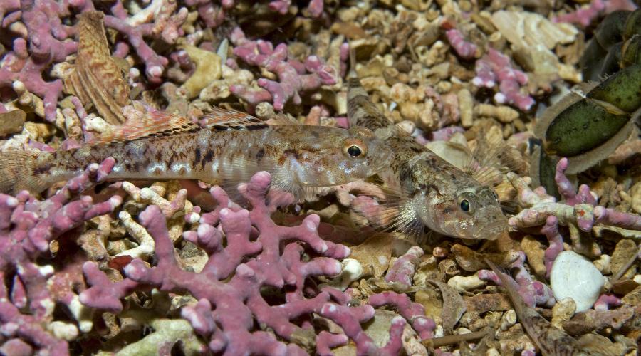
Maerl beds play an important role in habitat creation. The complex habitat provided by maerl supports a disproportionately high number of other species including commercial fish and shellfish and contributes to the protection of biodiversity.
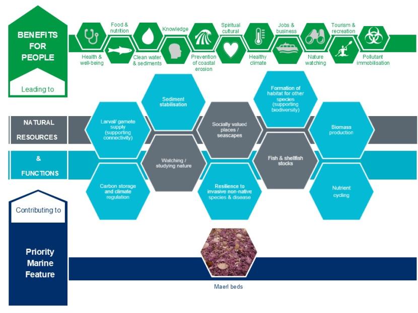
The contribution maerl beds make to natural resources and functions and the benefits for people that these lead to.
Click for a full description
- Priority Marine Feature: Maerl beds contributing to
- Natural resources (NR) and functions (F)
- Laval/gamete supply (supporting connectivity (F)
- Carbon storage & climate regulation (F)
- Sediment stabilisation (F)
- Socially valued places/seascapes (NR)
- Nutrient cycling (F)
- Watching/studying nature (NR)
- Fish and shellfish stocks (NR
- Biomass production (F)
- Resilience to invasive non-native species & disease (F)
- Formulation of habitat for other species (supporting biodiversity) (F)
- Which leads to benefits for people
- Health & wellbeing
- Spiritual/cultural
- Clean water & sediments
- Pollutant immobilisation
- Knowledge
- Food and nutrition
- Prevention of coastal erosion
- Healthy climate
- Jobs and business
- Nature watching
- Tourism and recreation
Existing Marine Protected Areas
Maerl beds are a protected feature of 11 MPAs: Loch Laxford; Wyre and Rousay Sounds; Loch Sween; South Arran; Luce Bay; Wester Ross; Loch Carron; Sound of Arisaig; Sound of Barra; Loch nam Madadh; and Fetlar to Haroldswick.
Existing and proposed fishing measures providing PMF protection
Maerl beds are protected by the following existing fishing measures:
- The Inshore Fishing (Scotland) Order 2015 (Loch Laxford; Treshnish Isles; Lochs Duich, Long and Alsh (through the combined Southern Inner Sound measures CA150); Loch Sunart; Upper Loch Fyne and Loch Goil; Wyre and Rousay Sounds; and Loch Sween).
- The South Arran Marine Conservation Order 2015.
- The Inshore Fishing Order for Luce Bay 2015.
- The Wester Ross Marine Conservation Order 2016.
- The Loch Carron Marine Conservation Order 2019.
- The Red Rocks and Longay Marine Conservation Order 2022.
- The Loch Gairloch (CA58) and Loch Torridon and Northern Inner Sound (CA56) fisheries areas and the BUTEC Inner and Outer Sea Areas (British Underwater Test and Evaluation Centre).
New fishing measures are proposed which will protect maerl beds in the following MPAs:
- Sound of Arisaig; Sound of Barra; Small Isles; Loch nam Madadh and Fetlar to Haroldswick
The Shetland Shellfish Management Organisation (SSMO) is the regulator for shellfish fisheries within Shetland’s six-mile limit. There is a requirement that measures to manage scallop dredging activity within relevant MPAs will be introduced by the SSMO to complement measures proposed by Marine Directorate and provide the necessary protection for designated habitats and species (including the PMFs covered by this review). Existing SSMO measures encompass a number of maerl bed records in the Fetlar to Haroldswick MPA.
Approach to assessing improvements in management needed to protect maerl beds from impacts related to towed bottom-contacting fishing gear
The assessment presented in this document relates to fishing using towed bottom-contacting gear only. It is consistent with the approach taken for assessing proposed developments.
When considering biodiversity evidence more weight has been given to clusters of maerl records in preference to isolated observations, and around larger beds in preference to smaller ones (where known), except where smaller or fragmented beds are the only (remaining) examples in a geographic area. This is the case in the Clyde, where maerl habitats are generally severely degraded and we recommend all remaining beds require protection to support recovery of the PMF. The habitat’s inherent patchy nature, and the distribution of the associated maerl or coarse shell gravel with burrowing sea cucumbers PMF, with which it forms mosaic habitats has also been taken into account.
Consideration of key locations for maerl beds has included ensuring the areas/locations are distributed to cover the full range of environmental conditions in which maerl beds occur and the different associated bed forms (e.g exposure, depth, geographic range, substrate, rhodolith form etc.) and the connectivity of beds.
A greater biological diversity of associated faunal and floral communities, a higher percentage of live maerl material and a greater thickness of maerl bed are factors which increase the conservation importance of a bed. Information on these characteristics does not exist for all records in Scottish waters precluding their detailed application in this assessment. However, such information should be sought and used in development licensing and consenting processes.
Any towed bottom-contacting fishing activity that leads to the loss of entire beds or damage to beds, such that function or provision of ecosystem services cannot be maintained should be considered to have a significant impact on national status and as a result not meet General Policy 9(b) in the National Marine Plan. Existing licensing and consenting processes will continue to consider the potential for significant impacts on maerl beds.
Key locations for the protection of maerl beds outside designated sites and existing towed bottom-contacting fisheries restrictions
Summary
We recommend that the development of spatial fisheries measures to protect maerl beds from pressures associated with towed bottom-contacting gears should cover records of the feature within the following key locations (outside of MPAs that protect this feature and areas with existing fisheries measures). These are shown in Map 2: Clyde; Orkney; Shetland; around Skye; Inner Sound; north-west of Scotland; Lewis and Harris; Uists; north-west Mull; Arisaig; Islay and Jura; and Gigha.
The recommendations for subtidal maerl beds need to be considered alongside the recommendations for the other 10 PMFsconsidered as part of the development of PMF management areas. These recommendations are based on biodiversity evidence taking into consideration the information above and have been provided to help inform the development of fishing measures, led by Marine Directorate.
If fisheries management measures were established to protect records in all these key locations it would achieve substantial protection for maerl beds, complementing the protection already in place for some MPAs and proposed for other MPAs (see map 2).
Details of locations
In the Clyde, maerl habitats are generally severly degraded and it is recommended that all remaining beds require protection to support PMF recovery and increase resilience.
Orkney is possibly Scotland’s most important area for maerl beds, both in quantity and quality. The vast majority of maerl bed records in Orkney lie outwith the MPA network and are widespread, ranging from Papa Westray to South Walls and can be found as far east as Sanday Sound. The beds throughout Gairsay and Shapinsay Sounds, Ventrow Bay and Wide Firth together with the beds in the Wyre and Rousay MPA are considered to be the largest complex of maerl beds in the UK (Hirst et al., 2012, unpublished) and the maerl beds in the Gutter Sound form a mosiac with the most northenly known examples of flame shell beds in Scottish waters.
In Shetland a number of maerl bed records are afforded partial or no protection. For example, SSMO prohibitions are in place for sensitive habitats including maerl beds. However, these are for scallop dredging only, i.e. they do not cover all towed bottom-contacting gear, and are a mix of both voluntary (e.g. Mousa) and statutory (e.g. Lunning Sound, Wadbister Voe and Cat Firth and The Vadills) closed areas. Work undertaken in 2011 in relation to a development proposal (Hjaltland Seafarms Ltd., 2011) recorded maerl beds not currently covered by fisheries measures to the north of Papa and their extent was further mapped in 2019 as part of a Marine Directorate-led European Maritime and Fisheries Fund (EMFF) survey and by the University of the Highlands and Islands (UHI) Shetland (Shelmerdine & Mouat, 2020). The UHI Shetland survey also confirmed beds to the north of Lunna Ness.
Maerl beds around north and west Skye as well as records in south Skye, in Lochs Eishort and Slapin and Scavaig (Moore, 2015 & 2017), should be considered. While some maerl beds to the east of Skye are afforded protection by the Red Rocks and Longay MPA serveral other records still require protection alongside other PMFs including around the islands of Pabay and Scalpay. More recent records have helped to supported the suggestion that a maerl band may exist along the coastline of the Inner Sound (Moore et al., 2011; Moore & Atkinson, 2012; Moore, 2019), with unprotected records extending from north of the Crowlin Islands to Port Erradale (Gairloch), often alongside flame shell beds.
On the north-west coast, from Kylesku to Loch Eriboll, only the records in Loch Laxford MPA are currently afforded protection. Records from Loch Eriboll, Handa and Edrachillis Bay should be considered for protection to fill this gap.
In the Outer Hebrides, there are multiple unprotected records that should be considered as they are high quality beds that represent a range of environmental conditions. In Lewis and Harris this includes Loch Seaforth, Sound of Taransay and the Sound of Harris and along the west coast of the Uists.
Records from the north-west of Mull, Poll Athach (Loch a' Chumhainn) and Ulva, to Arisaig (Loch nan Ceall), Eigg, Sandaig Bay (Loch Nevis) and Loch Hourn should be considered along with records around Jura (Loch Tarbert) and Islay (including Port Ellen and the Sound of Islay) as well as West Loch Tarbert and south Gigha.
Data confidence
We have recent records from 2022. Surveys vary in scope from Seasearch (carried out by volunteer divers) to dedicated PMF validation surveys (e.g. 2014 SNH South Skye sea lochs benthic camera survey). Records come primarily from diving and remote video surveys with a smaller number of records from infaunal grab samples.
Maerl bed records in Shetland were cross-checked against the results of survey work undertaken by UHI Shetland (Shelmerdine et al., 2014 and Shelmerdine & Mouat, 2020). The maps provided in both papers include provisional new records of the PMF not currently held in the database. A process to incorporate relevant, confirmed PMF data, collated as part of the Shetland Islands Marine Spatial Plan (SIMSP) is in development. These records will be mobilised via future updates to Marine Directorate’s National Marine Plan interactive (NMPi) online tool.
Knowledge gaps and other recommended work
We recommend further survey work to identify additional maerl beds and other locations that may support maerl bed recovery. This would bring additional associated biodiversity benefits and ecosystem services and could be achieved by:
- Exploring the use of modelled predictions for maerl beds where data gaps exists, using the latest models available (e.g. SDM species distribution models) combined with ground truthing (targeted surveys) to facilitate their validation.
- Including a more precautionary approach in boundary setting for some of the suggested PMF areas, where habitat requirements for maerl beds are suitable but where there is currently a lack of biodiversity evidence (e.g. Handa, Loch Bay, Loch nan Uamh, Arisaig and the Sound of Harris).
Key locations for the protection of maerl beds outside MPAs with management measures and existing towed bottom-contacting fisheries restrictions
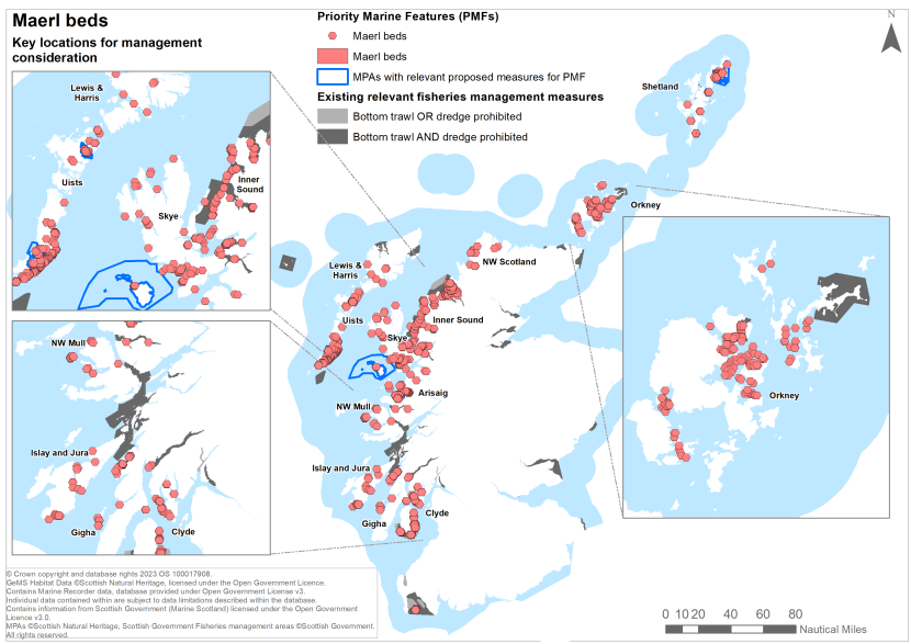
Key locations for the protection of maerl beds outside of MPAs with management measures and existing towed bottom-contacting fisheries restrictions.
Click for a full description
For further details about the locations marked in this map see above, section Key locations for the protection of maerl beds outside designated sites and existing towed bottom-contacting fisheries restrictions.
References
Birchenough, S.N.R., Bremner, J., Henderson, P., Hinz, H., Jenkins, S., Mieszkowska, N., Roberts, M.J., Kamenos, N. & Plenty, S. 2013. Impacts of climate change on shallow and shelf subtidal habitats. MCCIP Science Review 2013: 193-203.
Birkett, D.A., Maggs, C.A. & Dring, M.J. 1998. Maerl (volume V). An overview of dynamic and sensitivity characteristics for conservation management of marine SACs. Scottish Association for Marine Science (UK Marine SACs Project), 117 pages.
Burrows, M.T., Hughes, D.J., Austin, W.E.N., Smeaton, C., Hicks, N., Howe, J.A., Allen, C., Taylor, P. & Vare, L.L. 2017. Assessment of Blue Carbon Resources in Scotland’s Inshore Marine Protected Area Network. Scottish Natural Heritage Commissioned Report No. 957.
ERT (Scotland) Ltd. 2006. Site Condition Monitoring: surveys of lagoons in the Vadills Lagoon Special Area of Conservation, July-August 2003. Scottish Natural Heritage Commissioned Report No. 209.
European Commission. 2013. Interpretation manual of European Union habitats. EUR 28, 144 pages.
Hall-Spencer, J.M., Grall, J., Moore, P.G. & Atkinson, R.J.A. 2003. Bivalve fishing and maerl-bed conservation in France and the UK - retrospect and prospect. Aquatic Conservation: Marine and Freshwater Ecosystems, 13: S33-S41.
Hall-Spencer, J.M. & Moore, P.G. 2000. Scallop dredging has profound, long-term impacts on maerl habitats. ICES Journal of Marine Science, 57: 1407-1415.
Hall-Spencer, J., White, N., Gillespie, E., Gillham, K. & Foggo, A. 2006. Impact of fish farms on maerl beds in strongly tidal areas. Marine Ecology Progress Series, 326: 1-9.
Hauton, C., Hall-Spencer, J.M. & Moore, P.G. 2003. An experimental study of the ecological impacts of hydraulic bivalve dredging on maerl. ICES Journal of Marine Science, 60: 381-392.
Hjaltland Seafarms Ltd. 2011. 2011 North of Papa seabed video survey.
Lancaster, J. (Ed.), McCallum, S., Lowe A.C., Taylor, E., Chapman A. & Pomfret, J. 2014. Development of detailed ecological guidance to support the application of the Scottish MPA selection guidelines in Scotland’s seas. Scottish Natural Heritage Commissioned Report No. 491. Maerl beds - supplementary document.
Mackinnon, M.C. & Lumb, C.M. 1988. Loch Sunart sublittoral survey. 10th - 11th October 1987. Nature Conservancy Council, CSD Report No. 794.
Martin, S. & Hall-Spencer, J.M. 2017. Effects of Ocean Warming and Acidification on Rhodolith/Maërl Beds. In, Riosmena-Rodriguez, R., Nelson, W. & Aquirre, eds. 2017. Rhodolith/Maërl Beds: A Global Perspective., Switzerland: Springer, Cham, Coastal Research Library vol 15: 55-85.
Mazik, K., Strong, J., Little, S., Bhatia, N., Mander, L., Barnard, S. & Elliott, M. 2015. A review of the recovery potential and influencing factors of relevance to the management of habitats and species within Marine Protected Areas around Scotland. Scottish Natural Heritage Commissioned Report No. 771.
MCCIP: Marine Climate Change Impacts Partnership. 2018. Climate change and marine conservation: Maerl beds. Russel, T. & Cunningham, S, ed. Lowestoft: MCCIP, 8 pages.
Moore, C.G. 2013. Biological analyses of underwater video from research cruises in Lochs Kishorn and Sunart, off the Mull of Kintyre and islands of Rum, Tiree and Islay, and in the Firth of Lorn and Sound of Mull approaches. Scottish Natural Heritage Commissioned Report No. 574.
Moore, C.G. 2015. Biological analyses of underwater video from research cruises in marine protected areas and renewable energy locations around Scotland in 2014. Scottish Natural Heritage Commissioned Report No. 819.
Moore, C.G. 2017. Biological analyses of underwater video from ongoing monitoring and research cruises in Lochs Sunart, Etive and Alsh, sea lochs off South Skye, the Sounds of Barra and Arisaig and around the Southern Trench. Scottish Natural Heritage Commissioned Report No. 959.
Moore, C.G. 2019. Biological analyses of underwater video from monitoring and research cruises in Lochs Ailort and Fyne, the Sounds of Barra and Mull, inner Moray Firth, off Wester Ross, Noss Head and Rattray Head, and around the Southern Trench in outer Moray Firth. Scottish Natural Heritage Research Report No. 1085.
Moore, C.G., Harries, D.B., Atkinson, R.J.A., Clark, L., Cook, R.L., Hirst, N.E., Saunders, G.R., Lyndon, A.R., Sanderson, W.G. & Porter, J.S. 2013. The distribution and condition of proposed protected features within the Loch Sween possible Nature Conservation MPA. Scottish Natural Heritage Commissioned Report No. 621.
Moore, C.G., Harries, D.B., James, B., Cook, R.L., Saunders, G.R, Tulbure, K.W., Harbour, R.P. & Kamphausen, L. 2018. The distribution and condition of flame shell beds and other Priority Marine Features in Loch Carron Marine Protected Area and adjacent waters. Scottish Natural Heritage Research Report No. 1038.
NatureScot. 2024. Geodatabase of Marine features adjacent to Scotland (GeMS). GeMS V10 (i26).
OSPAR. 2008. List of Threatened and/or Declining Species and Habitats. Reference Number: 2008-6.
OSPAR. 2010. Background document for maerl beds. Biodiversity Series. OSPAR Commission. Publication number: 491. ISBN 978-1-907390-32-6.
Perry, F. & Tyler-Walters, H. 2018. Maerl beds. In: Tyler-Walters, H. & Hiscock, K, eds. Marine Life Information Network: Biology and Sensitivity Key Information Reviews, [on-line]. Plymouth: Marine Biological Association of the United Kingdom.
Shelmerdine, R.L. & Mouat, B. 2020. Distribution of maerl and horse mussels (Modiolus modiolus) around Shetland: findings from a direct PMF survey. NAFC Marine Centre UHI.
Shelmerdine, R.L., Robinson, M., Johnson, A., Leslie, B., Stone, D. & Tait, L. 2013. Assessment of the appropriateness of areas closed to protect priority marine features from scallop dredging around Shetland. NAFC Marine Centre UHI.
Shelmerdine, R.L., Stone, D., Leslie, B. & Robinson, M. 2014. Implications of defining fisheries closed areas based on predicted habitats in Shetland: A proactive and precautionary approach. Marine Policy, 43: 184-199.
Thomson, M., Jackson, E. & Kakkonen, J. 2014. Seagrass (Zostera) beds in Orkney. Scottish Natural Heritage, Commissioned Report No. 765.
Wilson, S., Blake, C., Berges, J.A. & Maggs, C.A. 2004. Environmental tolerances of free-living coralline algae (maërl): implications for European marine conservation. Biological Conservation, 120(2): 279-289.