Clyde Valley Woodlands NNR - visiting the reserve leaflet
Welcome to Clyde Valley Woodlands National Nature Reserve
Scotland’s oldest and richest forest lies hidden in dramatic gorges in the Clyde Valley. Since the last Ice Age, rivers have gouged deep clefts in the soft sandstone: woods of oak, ash, rowan and hazel have been growing there since the ice melted away.
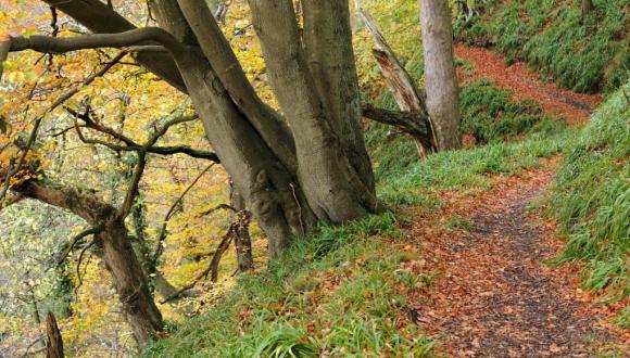
People have used these woods for centuries, managing the trees to provide small timber for fences and tools or pit props for mines. But the gorges were too steep to be completely cleared, and on the sheerest cliffs the trees have never been cut at all. The result is a mixed woodland of dappled sunlight, spring flowers and autumn fungi. Otters roam the riverbanks and badgers forage for food in the deep leaf litter, while birds like treecreepers, wrens and woodpeckers nest in the trees.
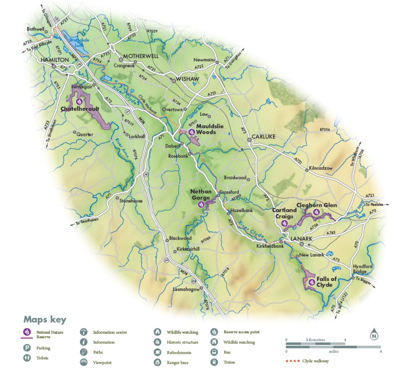
There are pockets of this beautiful woodland throughout the valley. Six of the best have been chosen to form a National Nature Reserve, where you’ll find car parks, clearly marked trails and more information about this remarkable environment.
Getting there
Need to know
Chatelherault and Falls of Clyde are popular visitor attractions, with cafés and toilets. There are places to eat and public toilets in Lanark, near Cartland Craigs & Cleghorn Glen, and in Crossford, near Nethan Gorge. There are steep slopes, unfenced cliffs and deep rivers on all the sites. Please take great care: stay on the paths and keep children and dogs under close control at all times.

Find out more
- Cartland Craigs & Cleghorn Glen are managed by NatureScot – for more information call 01738 457037 or visit nature.scot
- Falls of Clyde and Nethan Gorge are managed by The Scottish Wildlife Trust – for more information call 01555 665262 or visit scottishwildlifetrust.org.uk
- Chatelherault and Mauldslie Woods are managed by South Lanarkshire Council – for more information call 01698 426213 or visit southlanarkshire.gov.uk
- Follow @ScotlandsNNRs on social media
Reserve map
Falls of Clyde
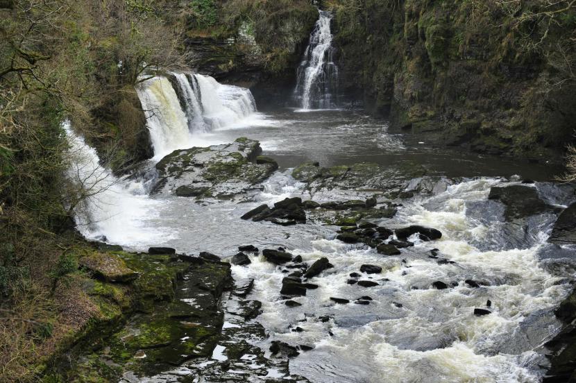
If you want to feel the power of the rivers that cut the Clyde Valley gorges, this is the place to come. Here the Clyde flows through deep, slow pools before rushing over the famous waterfalls – a visitor attraction for hundreds of years.
The ancient woodlands fringing the river are spectacular in all seasons. Look out for the little bobbing dipper, the bright flash of a kingfisher or an elusive otter slipping along the river. Bats can be spotted feeding over the river on warmer evenings and at dusk badgers forage amongst the undergrowth.
In 1786, David Dale harnessed the Clyde’s energy to drive the mills of New Lanark, which his son-in-law Robert Owen developed into a model industrial community. Britain’s first commercial hydro-electric scheme was built here in 1926. The elaborate system of pipes and dams are a reminder that the river is still a source of renewable energy today.
Way to go
Most trails are wide and well surfaced but can be muddy in places after wet weather. There are steep gradients and steps on all paths.
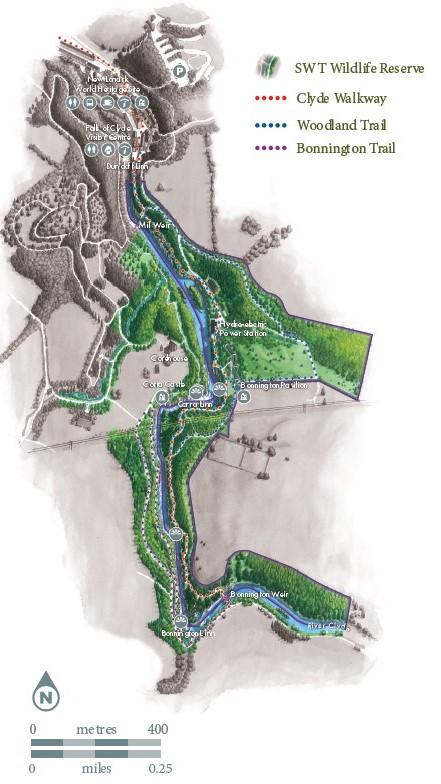
The Clyde Walkway from New Lanark to Bonnington Linn (3 miles / 5km out and back) visits all three waterfalls.
The Woodland Trail (2 miles / 3km) is a circular route through ancient woods. It gives spectacular views of Corra Linn, the highest of the falls.
Mauldslie Woods
The valley is more open here, with shallower slopes than the other sites in the Reserve. That made the trees easier to harvest, and in the 1800s the wood was cleared and replanted. Part of the site was once an orchard, one of many producing the apples, pears and plums for which the Clyde Valley was famous.
Now Mauldslie is managed to restore the role native woodland once played in the local economy, as well as the trees themselves. New trees will be planted, while work through the Clyde and Avon Valley Landscape Partnership aims to build new markets for timber, and to develop woodland management skills.
Way to go
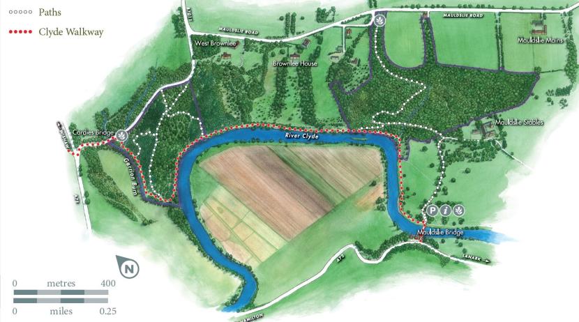
From the car park near Mauldslie Bridge, the path meanders through attractive open parkland before reaching the woods. There is a network of well surfaced paths in the woodland. They are steep in places and can be muddy after rain.
Chatelherault
The Clyde Valley’s dramatic gorges made it a fashionable tourist destination in the 1700s. Landowners vied with each other to make the most of the features on their ground, but none could compete with the money and care lavished by the Dukes of Hamilton on their vast estate at Chatelherault.
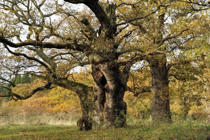
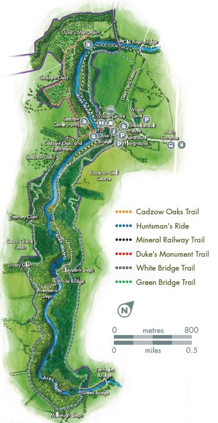
A grand hunting lodge marked the line between open parkland and the untamed gorge, with a terrace built to give the best possible view of the woods. Near the lodge are the Cadzow oaks: gnarled, twisted trees that are up to 800 years old.
Close to the river there’s the same mix of native species that make the Clyde Valley woodlands so rich for wildlife. Other areas were planted with conifers in the twentieth century, but they are gradually being returned to the wild woods the Dukes of Hamilton so admired.
Way to go
Chatelherault offers over 9 miles / 15km of trails through ancient woodlands and past historic features. Most trails are wide and well surfaced but can be muddy in places after wet weather.
The Cadzow Oaks Trail (0.5 mile / 0.8km) takes in the Duke’s Bridge, Earthworks and Cadzow Oaks. It has gentle slopes.
The Huntsman’s Ride (0.75 mile / 1.2km) goes through mixed woodland and across the Deer Park to the Grand Avenue. It’s mostly level.
The Mineral Railway Trail (1 mile / 1.7km) follows the river through mixed woodland. It’s mostly level with some steps.
The Duke’s Monument Trail (1.4 miles / 2.2km) takes in the Duke’s Bridge, Cadzow Castle ruins and Duke’s Monument. It has gentle slopes.
The White Bridge Trail (3.2 miles / 5.2km) follows the river before returning along the top of the gorge. It’s steep in places with steps.
The Green Bridge Trail (5 miles / 8km) takes you right along the top of the Avon Gorge. It’s steep in places with steps.
Nethan Gorge
Nethan may be the smallest of the six sites in the Reserve, but it’s one of the most spectacular. By the path you can see a few tree stumps with many stems growing from them: signs that the woodland was managed as coppice, with the trees cut every few years to harvest small timber.
But peer down through the leaves to the river far below and you’ll realise the trees on the gorge sides have never been cut. They grow undisturbed until their own weight makes them fall.
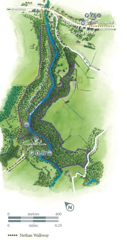
The dizzying cliffs made a perfect site for a fortress too. Craignethan Castle is an extraordinary fortified house, built around 1530 by Sir James Hamilton. It makes a great starting place for a visit to the gorge.
Way to go
A trail runs along the edge of the gorge between Crossford and Craignethan Castle (0.75 mile /1.2km). The path is well surfaced but narrow and steep in places, with many steps. The best access is from the castle, which you can visit during opening times. For access from Crossford, park in the village and join the trail at the bridge over the River Nethan.
Cartland Craigs & Cleghorn Glen
The Mouse Water flows for just 12 kilometres from the peaty moorlands above Lanark before joining the River Clyde. This short river is surprisingly powerful, rising quickly after heavy rain.
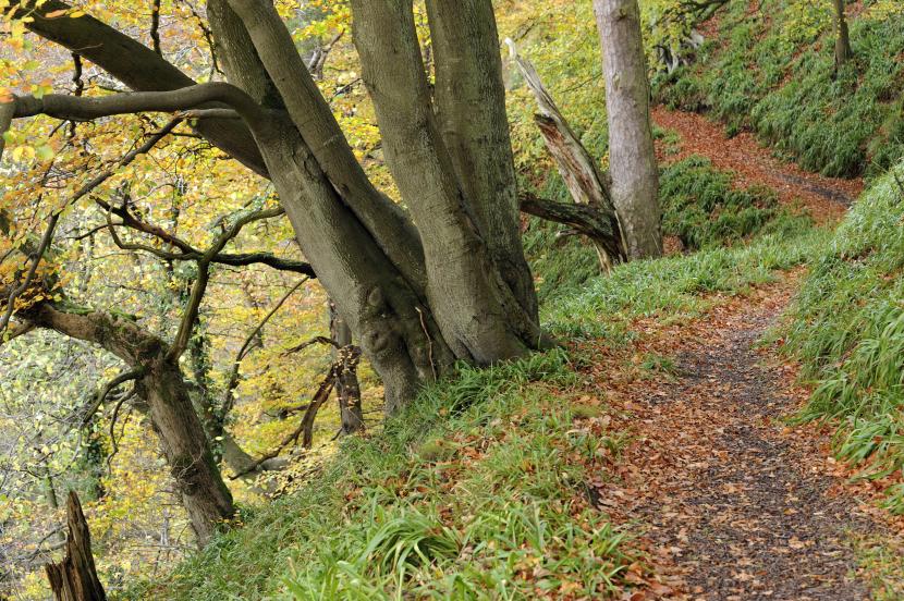
The woods along its valley are delightful. The trees were managed partly as coppice until the 1930s: they’re still cut regularly so that light can reach the woodland floor, where wildflowers like primroses and herb Paris grow. In places the ground is more acidic and you’ll find patches of heather and blaeberry under Scots pines. By the river you can watch for dippers that bob on the rocks before they dive under the water to search for insects.
Way to go
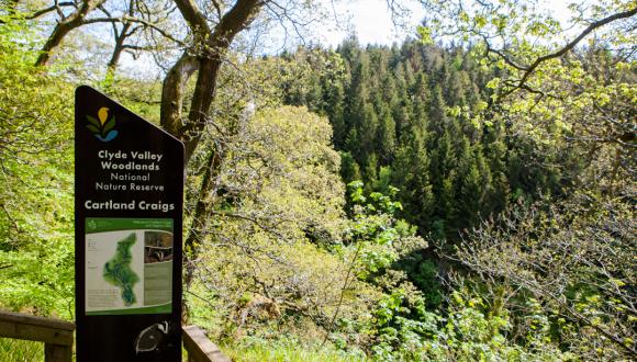
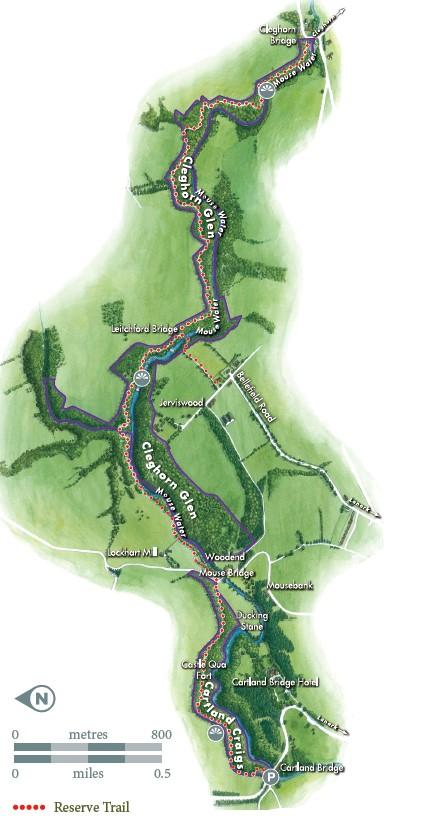
The trail follows the gorge for the length of the Reserve between Cartland Bridge and Cleghorn Bridge (5.6 miles / 9km out and back). The path is mostly level but narrow and can be muddy in places after rain. From Lanark, you can enter the Reserve at Leitchford Bridge and make a circular route using tracks and minor roads.
Find out more on
- Visiting the reserve
- About the reserve
- Visit more of our nature reserves
