Review of changes to proposed fisheries management boundaries Fetlar to Haroldswick MPA
Please note - The advice below was produced in June 2020 to assist the development of proposed management measures for fishing activity for MPAs. Further considerations were made by Marine Directorate and the final proposed management measures being consulted upon in 2026 are available via Scottish Government’s website.
June 2020
Overview of proposed changes
The MPA supports five seabed habitat protected features - Circalittoral sand and coarse sediment communities; Horse mussel beds; Kelp and seaweed communities on sublittoral sediment; Maerl beds; & Shallow tide-swept coarse sands with burrowing bivalves (see Table 1 for details of protected features and management advice).
The Shetland Shellfish Management Organisation (SSMO) manages and regulates the fisheries (e.g. dredging) for shellfish within Shetland’s six-mile limit. Marine Scotland (MS) (now Marine Directorate) manages other fisheries in Shetland waters.
The proposed refinements to the original proposed trawl management boundary (Figure 1) iscussed at the fisheries stakeholder meeting on 20 January 2020 are at the southern end of Colgrave Sound; resulting in the initial Marine Scotland trawl management boundary (being ‘indented’ northwards along the 40 m bathymetry contour (Figures 2 and 3). This change only affects the coverage of the Circalittoral sand and coarse sediment communities (see Detailed Assessment Against the Selection Guidelines document) representative feature. This comprises the following habitats -
- ‘Circalittoral coarse sediment’ (SS.SCS.CCS) and in particular ‘Mediomastus fragilis, Lumbrineris spp. and venerid bivalves in circalittoral coarse sand or gravel’ (SS.SCS.CCS[.MedLumVen] - A5.14[2])
- ‘Circalittoral fine sand’ (SS.SSa.CFiSa - A5.25).
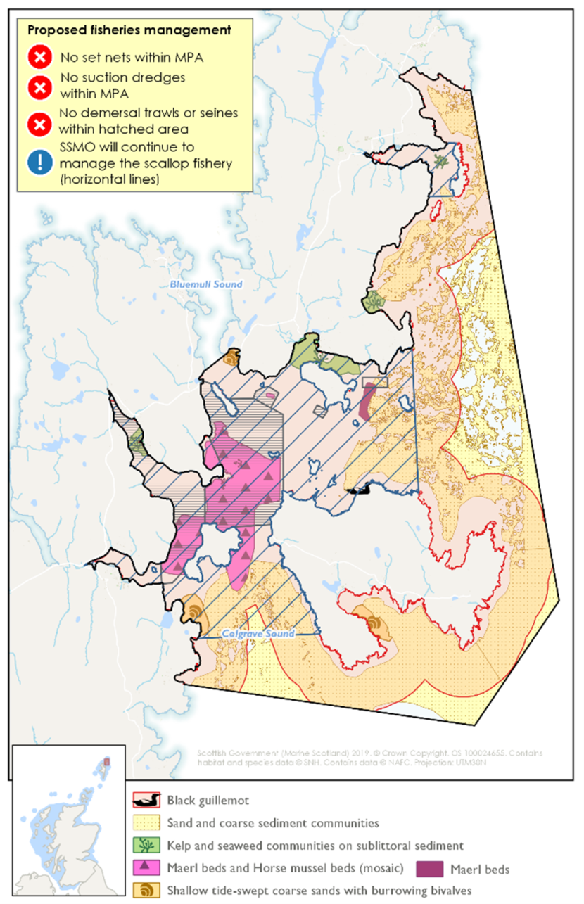
Figure 1. Original Marine Scotland (now Marine Directorate) management proposal for Fetlar to Haroldswick MPA.
| Feature | Mobile gear | Static gear | Other |
|---|---|---|---|
| Maerl beds | Remove / avoid pressure from mobile / active gear (for hydraulic – see ‘Other’) | Consider reduce / limit pressure | Remove / avoid pressure from diver operated hydraulic fishing methods. Consider reduce / limit collection of burrowing bivalves by hand. |
| Horse mussel beds | Remove / avoid pressure from mobile / active gear (for hydraulic – see ‘Other’) | Consider reduce / limit pressure | Remove / avoid pressure from diver operated hydraulic fishing methods. Consider reduce / limit collection of burrowing bivalves by hand. Remove / avoid targeted removal of the species. |
| Black guillemot | No management required | Remove / avoid pressures from set nets | |
| Shallow tide-swept coarse sands with burrowing bivalves | Reduce / limit pressure from targeted fishing for burrowing bivalves | No additional management | Remove / avoid pressure from diver operated hydraulic fishing methods. Consider reduce / limit collection of burrowing bivalves by hand. |
| Kelp and seaweed communities on sublittoral sediment | Consider reduce / limit pressure from mobile / active gear (for hydraulic – ‘Other’) | No additional management | Remove / avoid pressure from diver operated hydraulic fishing methods. |
| Circalittoral sand and coarse sediment communities | Consider reduce / limit pressure from mobile / active gear (for hydraulic – see ‘Other’) | No additional management | Remove / avoid pressure from diver operated hydraulic fishing methods.
|
In both Figures 2 and 3 the blue line shows the path of the previous draft MS fisheries management boundary and the green line (overlapping for the most part) shows the initial amendment made in Colgrave Sound following discussions with stakeholders (April 2020).
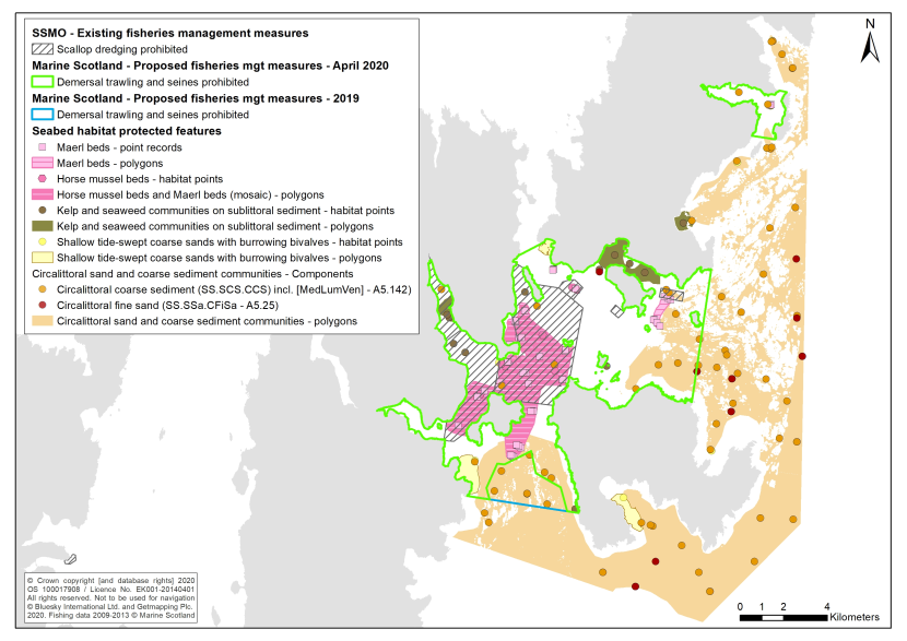
Figure 1. Map1 showing changes to proposed MS-led fisheries management measures in the Fetlar to Haroldswick MPA following initial stakeholder discussions.
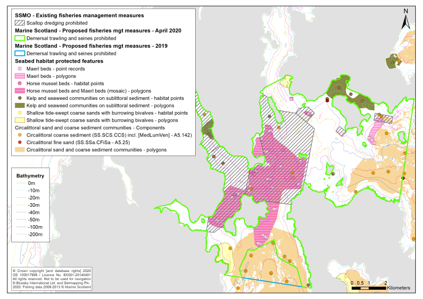
Figure 3. Map2 showing changes to proposed MS-led fisheries management measures in the Fetlar to Haroldswick MPA following initial stakeholder discussions.
Proportion of seabed habitat features covered by the different management scenarios
The proportion of each seabed habitat protected feature encompassed by existing SSMO measures (for dredging) and Marine Scotland’s original (2019) and revised (April 2020) management scenarios (for demersal trawls and seines) is set out in Tables 2 and 3. Following a preliminary assessment, additional management zones were added in June 2020 to increase the coverage of the Circalittoral sands and coarse sediment communities protected feature. These additional areas are included in the tables below and illustrated on Figure 4.
| Protected feature | Total area of habitat in MPA (ha) | SSMO management area within boundary (ha) | SSMO % of total habitat in management areas | 2019 Area within boundary (ha) | 2019 % of total habitat in management areas | April 2020 Area within boundary (ha) | April 2020 % of total habitat in management areas | June 2020 Area within boundary (ha) | June 2020 % of total habitat in management areas |
|---|---|---|---|---|---|---|---|---|---|
| Maerl beds | 58.4 | 6.9 | 11.8% | 58.4 | 100% | 58.4 | 100% | 58.4 | 100% |
| Horse mussel beds / maerl bed mosaic | 1380.8 | 1129.3 | 81.8% | 1380.0 | 100% | 1380.0 | 100% | 1380.0 | 100% |
| Kelp and seaweed communities on sublittoral sediment | 306.6 | 46.9 | 15.3% | 251.0 | 81.9% | 251.0 | 81.9% | 301.5 | 98.3% |
| Shallow tide-swept sands with burrowing bivalves | 231.4 | 0 | 0% | 139.7 | 60.4% | 139.7 | 60.4% | 139.7 | 60.4% |
| Circalittoral sands and coarse sediment communities | 9674.3 | 14.5 | 0.1% | 1710.9 | 17.7% | 1208.6 | 12.5% | 2042.5 | 21.1% |
| Protected feature | Total habitat points in MPA | SSMO No. of points within mgt. area | SSMO % of points within mgt. area | 2019 No. of points within mgt. area | 2019 % of points within mgt. area | April 2020 No. of points within mgt. area | April 2020 % of points within mgt. area | June 2020 No. of points within mgt. area | June 2020 % of points within mgt. area |
|---|---|---|---|---|---|---|---|---|---|
| Maerl beds | 50 | 29 | 58% | 50 | 100% | 50 | 100% | 50 | 100% |
| Horse mussel beds | 13 | 13 | 100% | 13 | 100% | 13 | 100% | 13 | 100% |
| Kelp and seaweed communities on sublittoral sediment | 20 | 11 | 55% | 19 | 95% | 19 | 95% | 19 | 95% |
| Shallow tide-swept sands with burrowing bivalves | 9 | 1 | 11.1% | 2 | 22.2% | 2 | 22.2% | 3 | 33.3% |
| Circalittoral sands and coarse sediment communities (all points) | 87 | 6 | 6.9% | 23 | 26.4% | 17 | 19.5% | 35 | 40.2% |
| Component: Circalittoral coarse sediment (SS.SCS.CCS) and in particular ‘Mediomastus fragilis, Lumbrineris spp. and venerid bivalves in circalittoral coarse sand or gravel habitats’ (SS.SCS.CCS.[MedLumVen] - A5.142) | 73 | 6 | 8.2% | 22 | 30.1% | 16 | 21.9% | 27 | 37.0% |
| Component: Circalittoral fine sand (SS.SSa.CFiSa - A5.25) | 14 | 0 | 0% | 1 | 7.1% | 1 | 7.1% | 9 | 64.3% |
Conclusions
Maerl beds and horse mussel beds
Based on Scottish Natural Heritage’s (SNH, now NatureScot) advice to remove/avoid pressures from demersal mobile fishing gear (including dredging) over maerl beds and horse mussel beds (i.e. 100% of the habitat) the current closed areas in place for dredging by SSMO are not adequate to meet the conservation objectives for these features in the MPA. A large proportion of the extensive horse mussel beds / maerl beds mosaic polygon area is covered (~81.8%) but recent records have extended the polygon to the south and newly mapped maerl beds now lie outside SSMO measures (coverage of only 11.8%). Similarly, only around a half of the maerl point data are included in the current closures.
All MS management scenarios (2019 and 2020) for demersal trawling/seine netting would cover 100% of the polygons for these habitats and all of the point records.
Kelp and seaweed communities on shallow sublittoral sediment
This habitat is less sensitive to the pressures associated with mobile demersal fishing gear than maerl beds and horse mussel beds but more sensitive than the other tide-swept coarse and sandy sediment habitats present within the MPA. The degree to which this feature is affected by mobile/active gears will depend on the amount of ‘natural’ disturbance experienced (exposure) and the extent and frequency of fishing-related disturbance. Low energy sites with dense coverage of kelp and seaweeds will be most sensitive. This feature generally occurs in relatively shallow waters (typically less than 10 m) and so the fisheries interaction is likely to be minimal. Whilst there might be a focus on ensuring that relevant low energy examples of the habitat are protected, measures may also be relevant in more exposed parts of the MPA. This would mirror the approach taken in other sites (e.g. Luce Bay SAC).
The existing SSMO closed areas for dredging protect a relatively low percentage of both the polygon (15%) and the point data (55%) for this habitat. This is not adequate to meet the conservation objectives for this feature in the MPA. A large proportion of the habitat remains potentially exposed to fishing. We would recommend that the percentage covered by the SSMO measures move closer to that provided by the MS proposals.
All MS management scenarios (2019 and 2020) for demersal trawling/seine netting would cover the majority of the mapped polygons (82% or 98.3% for April and June 2020 scenarios respectively) and the point data (95%) for this habitat and would therefore be adequate for achieving the conservation objectives for this feature.
Shallow tide-swept sands with burrowing bivalves and Circalittoral sands and coarse sediment communities
ICES (2012) provided advice to the Fisheries Measures in Protected Areas (FIMPAS) project in relation to subtidal sandbanks in the Dogger Bank SAC (which includes similar sediment habitats to those present in the Fetlar to Haroldswick MPA). The request asked whether a proportionate approach that implemented measures covering between 20 and 40% of these habitats would be a sufficient level of protection. ICES were of the view that such a proportion would contribute to achieving the conservation objectives. These proportions need to represent all the different benthic communities and, in some cases, greater protection may be required. Sands and coarse sediments are the least sensitive to physical disturbance relative to the other habitats in the MPA and have some ability to recover, hence the reduce/limit pressure advice from SNH. The MPA also includes more stable soft sediments e.g. muddy sands as a component of the Circalittoral sands and coarse sediment communities. For Luce Bay SAC a 40% threshold was adopted which is broadly comparable with the proportion of soft sediment habitats included within the closed areas at other existing MPAs (around 30%).
The current SSMO closures do not cover an adequate proportion of either Shallow tide-swept sands with burrowing bivalves or Circalittoral sands and coarse sediment communities (based on both polygon and point data). None of the Shallow tide-swept sands with burrowing bivalves polygon data is covered and only a small percentage of the point data (11%). It is considered that this would not be adequate to meet the conservation objectives for this feature in the MPA. The existing SSMO closures do not represent a sufficient reduction/limitation of fishing pressures.
All MS options (2019 and 2020) for demersal trawling/seine netting would cover more than 40% of the mapped polygons for Shallow tide-swept sands with burrowing bivalves (~60%) and over 20% of the point data (22% under 2019 and April 2020 proposals and 33% under the June 2020 proposals).
However, only the June 2020 MS scenario, with an eastern extension to the main management area in Gruney Sound and a new area off Sandwick on Unst, falls within the recommended ICES range (at 21.1%) in terms of areal coverage of the Circalittoral sands and coarse sediment communities habitat.
Changes to MS’s 2019 management scenario, to address concerns raised by the fishing sector, reduced the area of representative habitat covered from 17.7% to 12.5% in the April 2020 boundary. SNH recommended that measures be introduced elsewhere in the MPA to increase coverage of this habitat (and the relative proportions of its component biotopes) in line with the ICES advice.
A sufficient number of point records are included for the coarse sediment component habitat (30.1% coverage under the 2019 scenario; 21.9% under the April 2020 measures and 37.0% under the June 2020 measures) but coverage of the circalittoral fine sand component biotope was very low (7.1%) under both the 2019 and April 2020 management scenarios. Whilst recognising the limitations of the % coverage approach (in terms of a relative paucity of survey coverage in the outer part of the MPA), an extension to the proposed management area above Fetlar was developed in June 2020 to address the shortfall in coverage of this finer sand habitat. The refinements to the proposed fisheries management measures are illustrated in Figure 4 (overleaf).
Subsequent stakeholder discussions envisaged later in 2020/2021 may result in further refinements to the proposed management measures.
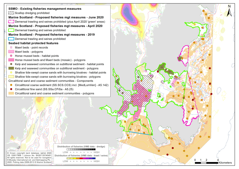
Figure 4. Map showing changes to proposed Marine Scotland-led fisheries management measures in the Fetlar to Haroldswick MPA - June 2020.
References
ICES (2012). Proposed fisheries measures for the Dogger Bank Special Area of Conservation. ICES Advice: Special Requests. Report.