Priority Marine Feature - Seagrass beds - subtidal only
Improving the protection given to Priority Marine Features
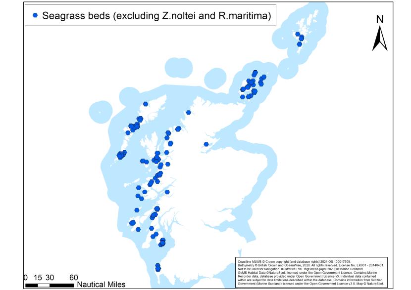
An overview of seagrass bed records
Description
Characteristics
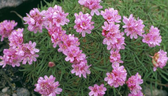
Seagrasses (also known as eelgrass) are marine flowering plants found in shallow coastal areas down to 10 m, often growing in dense beds or meadows. The plants can be annual or perennial and stabilise the sediment, creating productive habitats that provide shelter and food for a wide variety of plants and animals (including other species of conservation importance and commercially-valued fish species), as well as for carbon sequestration.
Zostera marina and a separate variant of the species, Z. marina var. angustifolia form subtidal seagrass beds (below mean low water spring tides) that are considered potentially at risk to towed bottom-contacting fishing activities. It is only these two subtidal habitats that are considered in this review. Intertidal beds of Zostera (Zosterella) noltei and subtidal Ruppia maritima are also part of the seagrass beds PMF but are not considered here because there are no overlaps with towed bottom-contacting fisheries.
Definition
OSPAR defines a Zostera ‘bed’ as having plant densities that provide at least 5% cover (OSPAR, 2009). Typically, Zostera plant densities provide greater than 30% cover and in favourable conditions, extensive beds may form with up to 95% cover (Lancaster et al., 2014a&b). A minimum area of 5 m x 5 m with at least 5% cover of seagrass is required to qualify as a seagrass bed.
Environmental preferences
Seagrasses grow in sands and muds from the upper shore down to 10 m, in areas at least moderately sheltered from wave action such as sea lochs, inlets, bays, sounds, channels and lagoons. Z. marina is predominantly subtidal, whilst the narrow-leaved variant, Z. marina var. angustifolia, can occur in the shallow subtidal and intertidally on the mid to lower shore.
Distribution
Scottish distribution
Subtidal seagrass beds have been recorded mainly on the west coast and around the Outer Hebrides, Orkney and Shetland.
Estimated known Scottish extent
Beds vary considerably in size, patchiness and plant density. The smallest of six beds surveyed in Gruinard Bay and Loch Gairloch in 2010 was a mere ~0.03 ha in extent, essentially a discrete patch of seagrass of less than 20 m diameter (Moore et al., 2011). In other parts of Scotland extensive seagrass coverage can be found for example in the Sound of Barra (est. 360 ha; Harries et al., 2007) and Sound of Harris (est. 280 ha; Malthus et al., 2006).
Wider distribution
Seagrass beds are recorded from Ireland, Wales and south-west England, and are widespread through the Atlantic and Pacific. Z. marina is the only seagrass species that extends into the Arctic Circle; it is found around Iceland and the north coast of Norway but has a restricted distribution in the Mediterranean where the intertidal Z. noltei is more prevalent (Borum et al., 2006).
Status
Scottish waters support an estimated 20% of the seagrass beds in north-west Europe. Currently UK seagrass populations are considered degraded following significant declines from a ‘wasting’ disease in the 1920s and ‘30s, with more recent declines recorded in the Outer Hebrides and Argyll (SMA, 2020). Seagrass beds (Zostera spp.) are an OSPAR threatened and / or declining habitat. This feature can be part of the broadscale habitats protected in Special Areas of Conservation (SACs): Coastal Lagoons; Mudflats and sandflats not covered by seawater at low tide; Sandbanks which are slightly covered by sea water all the time; and, Estuaries under Annex 1 of the EU Habitats Directive (European Commission, 2013). The Directive is transposed into domestic legislation through The Conservation (Natural Habitats, &c.) Regulations 1994 (as amended in Scotland) (Habitats Regulations).
Drivers for improving protection
Seagrass beds are included on the PMF list which means that National Marine Plan General Policy 9(b) (avoiding significant impact on national status) applies. Seagrass beds are an OSPAR threatened and declining habitat in need of protection. The Scottish Biodiversity Strategy to 2045, the Scottish Biodiversity Duty and UK Marine Strategy Good Environmental Status provide further drivers to ensure biological diversity is restored, and ecosystems are safeguarded.
Sensitivity (including recovery)
[Key sources: FeAST, Fisheries Management Guidance]
Seagrass beds are sensitive habitats, particularly to smothering, organic enrichment, nutrient enrichment, physical disturbance, changes in water flow and clarity, and non-indigenous invasive species (e.g. Spartina spp.) (OSPAR, 2009; Jackson et al., 2013; d’Avack et al., 2014; d’Avack et al., 2015a&b). An epidemic wasting disease has caused severe declines to seagrass beds across Europe in the past (Jackson et al., 2013) and anthropogenic stresses may increase susceptibility to disease. Activities associated with these pressures include coastal development, aquaculture, anchoring and bottom-contacting fishing which may cause disruption of the seagrass root system (rhizomes) within the sediment leading to increased patchiness, destabilisation and erosion of the seagrass bed. Increases in fragmentation are thought to be more damaging than total area of seagrass bed loss (Jackson et al., 2013).
Seagrass beds may be vulnerable to future climate impacts associated with marine heatwaves, changes in circulation patterns, changes in sea level, increased storminess, increased run-off from land, increased pathogens, and de-oxygenation (Serrano et al., 2021, Rasmusson et al., 2020, Hughes et al., 2018; Jakobsson-Thor et al., 2020, Johannessen, 2022; Silva et al., 2020).
Recovery depends mainly on vegetative growth of rhizomes from perennial beds rather than natural seedling production (Jackson et al., 2013; d’Avack et al., 2014). The recovery of seagrass habitat from towed bottom-contacting fishing gear disturbance can take between 6 to 20 years depending on the amount of damage (Neckles et al., 2005). Once lost, seagrass beds take considerable time to re-establish (OSPAR, 2009; Jackson et al., 2013; d’Avack et al., 2014; d’Avack et al., 2015a&b; Tyler-Walters & d’Avack, 2015) and may potentially not recover if all rhizomes are lost or damaged and sediment dynamics change. Relevant techniques for seagrass restoration are being developed and restoration is underway or in the planning stages in locations around Scotland. Development into mature bed takes many years and the knock-on ecosystem effects may not be measurable for a decade or so (Kent et al., 2021).
Connectivity
Between seagrass beds
Seagrass seed dispersal has the potential to cover large distances; however, high seedling mortality and seed predation may significantly reduce effective recruitment (Phillips & Menez, 1988). There is evidence in the Skagerrak-Kattegat region of the North Sea that seagrasses also transfer genetic information using passive raftings of flowering shoots - the main driver of gene flow in this area (Jahnke, et al., 2018). Currently work is taking place to better understand connectivity between Scottish seagrass beds. Interim results suggest that there are distinct clusters in Scotland and that some beds are connected.
With regards to expansion, most seagrass beds seem to rely on vegetative growth from existing rhizomes (Holt et al., 1997; Davison & Hughes, 1998). Additional management could help provide connectivity between beds, including with those within the MPA network.
With other PMFs
Subtidal seagrass beds have been found rooted within maerl beds PMF (e.g. in Wyre, Rousay and Gairsay Sounds in Orkney (Thomson et al., 2014)), and also in Loch Sween. Native oysters PMF may also be found within seagrass beds.
Seagrass beds sometimes overlay the tide-swept coarse sands with burrowing bivalves PMF, offering bivalves protection through shelter and stability (Lancaster et al., 2014a&b). Seagrass at low abundance (insufficient to be recognised as a bed) may form part of the kelp and seaweed communities on sublittoral sediment PMF in some locations. Low or variable salinity habitats PMF can often support seagrass beds, helping to stabilise the sediment, which can increase biodiversity and input of organic matter (d’Avack et al., 2015).
Ecosystems services
Seagrass beds are actionable blue carbon ecosystems. Such ecosystems are considered to play a role in climate mitigation via the sequestration and storage of organic carbon. The habitat provided by seagrass beds supports a number of other species including juvenile commercial species such as cod, plaice and herring, and contributes to the protection of biodiversity.
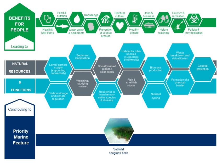
The contribution seagrass beds make to natural resources and functions and the benefits for people that these lead to.
Click for a full description
- Priority Marine Feature: Seagrass beds contributing to
- Natural resources (NR) and functions (F)
- Waste breakdown and detoxification of water and other sediments (F)
- Socially valued places/seascapes (NR))
- Resilience to invasive non-native species & disease (F)
- Formulation of habitat for other species (supporting biodiversity) (F)
- Fish and shellfish stocks (NR)
- Watching/studying nature (NR)
- Laval/gamete supply (supporting connectivity (F)
- Carbon storage & climate regulation (F)
- Sediment stabilisation (F)
- Biomass production (F)
- Nutrient cycling (F)
- Formulation of a physical barrier (F)
- Coastal protection (F)
- Which leads to benefits for people
- Health & wellbeing
- Knowledge
- Clean water and sediments
- Jobs and business
- Spiritual/cultural
- Nature watching
- Food and nutrition
- Tourism and recreation
- Pollutant immobilsation
- Healthy climate
- Prevention of coastal erosion
Existing Marine Protected Areas
Subtidal seagrass beds are a protected feature of 9 MPAs: Sanday; South Arran; Sound of Arisaig; Sound of Barra; Loch nam Madadh; The Vadills; Loch Roag Lagoons; Obain Loch Euphoirt; and Loch of Stenness. The last 4 sites are considered inaccessible to towed bottom-contacting fishing activity, and support the Ruppia maritima component only, except The Vadills which also has one historic record of Zostera marina (although this was not relocated in 2003 (ERT (Scotland) Ltd., 2006)).
Existing and proposed fishing measures providing PMF protection
Seagrass beds are protected by the following existing fishing measures:
- The Inshore Fishing (Scotland) Order 2015 (Sanday; Loch Creran; Treshnish Isles; Lochs Duich, Long and Alsh (through the combined Southern Inner Sound measures CA150); Loch Sunart; Wyre and Rousay Sounds and Loch Sween).
- The South Arran Marine Conservation Order 2015.
- The Wester Ross Marine Conservation Order 2016.
- The Loch Carron Marine Conservation Order 2019.
- The Loch Gairloch (CA58); Loch Torridon and Northern Inner Sound (CA56); and Loch Roag (CA67) fisheries areas.
New fishing measures are proposed which will protect seagrass beds in the following MPAs:
- Sound of Arisaig, Sound of Barra, Small Isles and Loch nam Madadh.
The Shetland Shellfish Management Organisation (SSMO) is the regulator for shellfish fisheries within Shetland’s six-mile limit. There is a requirement that measures to manage scallop dredging activity within relevant MPAs will be introduced by the SSMO to complement measures proposed by Marine Directorate and provide the necessary protection for designated habitats and species (including the PMFs covered by this review). Existing SSMO measures encompass seagrass bed records in the Sullom Voe MPA although this is an intertidal record and considered inaccessible to towed bottom-contact fishing activity.
Approach to assessing improvements in management needed to protect seagrass beds from impacts related to towed bottom-contacting fishing gear
The assessment presented in this document relates to fishing using towed bottom-contacting gear only. It is consistent with the approach taken for assessing proposed developments.
When considering biodiversity evidence more weight has been given to recent records as well as clusters of seagrass records and records which show the extent of seagrass beds (i.e. polygon data) where available in preference to isolated observations. Aerial imagery evidence has been used to help determine extent and potential habitat where available and where seagrass records are limited. There has been particular consideration of larger beds in comparison to smaller ones (where extent is known), except where smaller or fragmented beds are the only remaining examples in a geographic area (e.g. between west and east Burra, Shetland) and require protection to support recovery of the PMF.
Consideration of key locations for seagrass beds has included ensuring the areas/locations are distributed to cover the full range of environmental conditions in which seagrass beds occur (type of wider environment e.g. sea loch vs. coastal, depth, geographic range, substrate, etc.), and the connectivity of beds.
A greater biological diversity of associated faunal and floral communities, a higher density of seagrass shoots, and greater bed extents are factors which increase the conservation importance of a bed. Information on these characteristics does not exist for all records in Scottish waters precluding their detailed application in this assessment. However, such information should be sought and used in development licensing and consenting processes.
Any towed bottom-contacting fishing activity that leads to the loss of entire beds or damage to beds, such that function or provision of ecosystem services cannot be maintained should be considered to have a significant impact on national status and as a result not meet General Policy 9(b) in the National Marine Plan. Existing licensing and consenting processes will continue to consider the potential for significant impacts on seagrass beds.
Key locations for the protection of seagrass beds outside designated sites and existing towed bottom-contacting fisheries restrictions
Summary
We recommend that the development of spatial fisheries measures to protect seagrass beds from pressures associated with towed bottom-contacting gears should cover records of the feature within the following key locations (outside of MPAs that protect this feature and areas with existing fisheries measures). These are shown in Map 2: south-west Shetland; Orkney; Eddrachillis Bay; Gairloch; south and east Skye; Harris; Ulva (Mull); Sound of Iona; Loch Craignish and Islay.
The recommendations for subtidal seagrass beds need to be considered alongside the recommendations for the other 10 PMFs considered as part of the development of PMF management areas. These recommendations are based on biodiversity evidence taking into consideration the information above and have been provided to help inform the development of fishing measures, led by Marine Directorate.
If fisheries management measures were established to protect records in all these key locations it would achieve substantial protection for subtidal seagrass beds, complementing the protection already in place for some MPAs and proposed for other MPAs (see map 2).
Details of locations
In Shetland, subtidal seagrass species Z. marina is restricted to the sheltered bays west of the Mainland (Shucksmith, 2017). The beds in Whiteness Voe are recorded as the most extensive seagrass beds in south-west Shetland and their continued presence has been confirmed in 2023 and 2024 (MacMinn, 2023 and Shucksmith, 2024, pers comms), however, fragmented beds that were known to be present between east and west Burra have not been relocated in recent years and protection here could help to support their recovery. All known subtidal records of seagrass beds in Shetland being considered in this review are already afforded partial protection through the SSMO prohibitions for scallop dredging. The Orkney beds are more widespread, around both the mainland and across the islands, with extensive beds in Deer Sound, Widewall Bay (Thomson et al., 2014), Bay of Tuquoy and Papa Westray and may still be under-recorded.
Northerly records include those in Eddrachillis Bay (where some beds were lost between 1987 and 2004; James, 2004) and a number of records adjacent to the existing fishing order in Loch Gairloch.
Around south and east Skye, the seagrass beds are interspersed with maerl beds in Lochs Eishort and Slapin (Moore et al., 2015) and are patchy in Loch Ainort (Dipper, 1981). The beds in the Sound of Harris are very extensive (280ha) and well developed, typically consisting of a series of dense bands (Malthus et al., 2006). A number of the beds previously recorded here using aerial imagery had their presence confirmed in 2021.
There are swathes of healthy seagrass beds (amongst patches of maerl gravel, with live maerl beds slightly deeper) at Traigh Bhain, to the south of Ulva (Mull) together with beds to the south of Inch Kenneth (Dipper, 2016) and in the Sound of Iona where large patches of seagrass are visible from aerial imagery.
Some of the existing seagrass beds in Loch Craignish are in more lagoonal areas and seagrass is a focal habitat of restoration work by the local community. The beds around Islay include more open coast examples in contrast to the Loch Sween seagrass beds that are part of the MPA network. The beds in Loch Indaal are particularly rich in biodiversity (Hiscock, 1983) and knowledge of their continued presence and extent was confirmed in 2023 (pers comms).
Other records
Records not accessible to towed bottom-contacting fishing gear have not been considered in the key locations for developing PMF management measures. Additionally, there are numerous additional observations of subtidal seagrass as a species. At low densities, such records may have been assigned to non-seagrass bed habitats. In some cases this may reflect a deterioration in condition of a former bed e.g. Skipness in the Clyde. These records are not reflected in the mapping presented.
Data confidence
We have recent records from 2023. Surveys vary in their original aims from Seasearch (carried out by volunteer divers), broadscale seabed habitat mapping (e.g. 2005 SNH Sound of Harris survey) to dedicated PMF validation (e.g. Ullapool approaches survey in 2010). Two records have been approximated from the Seagrass Spotter in Orkney to help refine our assessment. Additional seagrass records (species and beds) are available in Seagrass Spotter and the NBN Atlas. Work to collate and mobilise relevant PMF records to best inform future marine planning requirements is ongoing.
Knowledge gaps and other recommended work
We recommend continuing efforts to explore opportunities for collaborative monitoring, survey and research to improve our understanding of this habitat, for example:
- This feature is likely to be under-recorded, additional seagrass beds may be identified around the Scottish coastline. One route to addressing this could be to explore the use of modelled predictions for seagrass beds where data gaps exist, using the latest models available (e.g. SDM species distribution models) combined with ground-truthing (targeted surveys) to facilitate their validation.
- The numerous additional observations of subtidal seagrass as a species that are not reflected in the mapping may merit further survey to ascertain their presence, extent, condition and potential for recovery/restoration.
Key locations for the protection of seagrass beds
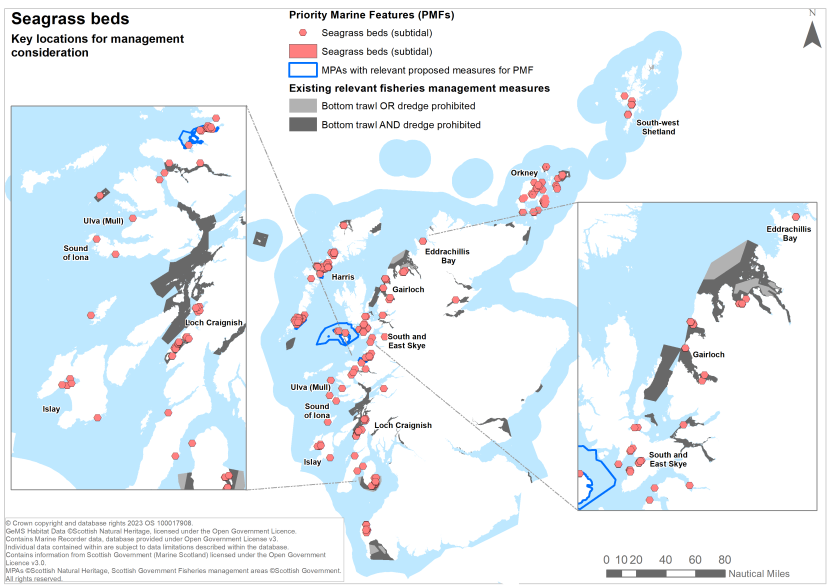
Key locations for the protection of seagrass beds outside of MPAs with management measures and existing towed bottom-contacting fisheries restrictions
Click for a full description
For further details about the locations marked in this map see above, section Key locations for the protection of seagrass beds outside designated sites and existing towed bottom-contacting fisheries restrictions.
References
d’Avack, E.A.S., Tillin, H., Jackson, E.L. & Tyler-Walters, H. 2014. Assessing the sensitivity of seagrass bed biotopes to pressures associated with marine activities. Peterborough: Joint Nature Conservation Committee.JNCC Report No. 505, 83 pages.
d'Avack, E.A.S., Tyler-Walters, H. & Wilding, C. 2015a. Zostera (Zostera) marina beds on lower shore or infralittoral clean or muddy sand. In: Tyler-Walters H. & Hiscock K, eds. Marine Life Information Network: Biology and Sensitivity Key Information Reviews, [on-line]. Plymouth: Marine Biological Association of the United Kingdom.
d'Avack, E.A.S., Tyler-Walters, H. & Wilding, C. 2015b. Zostera (Zosterella) noltei beds in littoral muddy sand. In: Tyler-Walters H. & Hiscock K, eds. Marine Life Information Network: Biology and Sensitivity Key Information Reviews, [on-line]. Plymouth: Marine Biological Association of the United Kingdom.
Davison, D. & Hughes, D. 1998. Zostera biotopes (volume I). An overview of dynamics and sensitivity characteristics for conservation management of marine SACs. Scottish Association for Marine Science (UK Marine SACs Project), 95 pages.
Dipper, F. 1981. Report of a sublittoral survey of south Skye, Inner Hebrides. Nature Conservancy Council. CSD Report No. 342.
Dipper, F. (Ed). 2016. Intertidal and sublittoral survey of islands within the Staffa Island group, Inner Hebrides. September 16-20, 2016. Porcupine Marine Natural History Society Field Trip Report.
ERT (Scotland) Ltd. 2006. Site Condition Monitoring: surveys of lagoons in the Vadills Lagoon Special Area of Conservation, July-August 2003. Scottish Natural Heritage Commissioned Report No. 209.
European Commission. 2013. Interpretation manual of European Union habitats. EUR 28, 144 pages.
Harries, D.B., Malthus, T.J., Karpouzli, E., Moore, C.G., Lyndon, A.R., Mair, J.M., Service, M. & Mitchell, A. 2007. Biotope mapping of the Sound of Barra, Scotland. Scottish Natural Heritage Commissioned Report No. 258.
Hiscock, K. 1983. Sublittoral survey of Jura and Islay. Nature Conservancy Council. CSD Report No. 476.
Hiscock, K. 1989. Marine biological survey of upper Whiteness Voe, Shetland Islands. 13 & 14 June 1989. Nature Conservancy Council. CSD Report No. 973.
Holt, T.J., Hartnol, R.G. & Hawkins, S.J. 1997. The sensitivity and vulnerability to man-induced change of selected communities: intertidal brown algal shrubs, Zostera beds and Sabellaria spinulosa reefs. English Nature Research Report No. 234.
Howson, C.M. 1999. Marine Nature Conservation Review Sector 1. Shetland: area summaries. Peterborough: Joint Nature Conservation Committee. Coasts and seas of the United Kingdom. MNCR series.
Hughes, R.G., Potouroglou, M., Ziauddin, Z. & Nicholls, J.C. 2018. Seagrass wasting disease: Nitrate enrichment and exposure to a herbicide (Diuron) increases susceptibility of Zostera marina to infection. Marine Pollution Bulletin, 134: 94-98.
Jackson, E.L., Griffiths, C.A. & Durkin, O. 2013. A guide to assessing and managing anthropogenic impact on marine angiosperm habitat - Part 1: Literature review. Natural England Commissioned Report No. 111.
Jahnke, M., Jonsson, P. R., Moksnes, P. O., Loo, L. O., Jacobi, M. N. & Olsen, J. L. 2018. Seascape genetics and biophysical connectivity modelling support conservation of the seagrass Zostera marina in the Skagerrak-Kattegat region of the eastern North Sea. Evolutionary Applications 11(5): 645-661.
Jakobsson-Thor, S., Brakel, J., Toth, G. B. & Pavia, H. 2020. Complex interactions of temperature, light and tissue damage on seagrass wasting disease in Zostera marina. Frontiers in Marine Science, 7: 575183.
James, B. 2004. North-west Scotland subtidal seagrass bed survey 2004. Scottish Natural Heritage Commissioned Report No. 076.
Johannessen, S. C. 2022. How can blue carbon burial in seagrass meadows increase long-term, net sequestration of carbon? A critical review. Environmental Research Letters, 17(9): 093004.
Kent, F., Lilley, R., Unsworth, R., Cunningham, S., Begg, T., Boulcott, P., Jeorrett, C., Horsburgh, R. & Michelotti, M. 2021 Seagrass restoration in Scotland - handbook and guidance. NatureScot Research Report No. 1286.
Lancaster, J. (Ed.), McCallum, S., Lowe, A.C., Taylor, E., Chapman, A. & Pomfret, J. 2014a. Development of detailed ecological guidance to support the application of the Scottish MPA selection guidelines in Scotland’s seas. Scottish Natural Heritage Commissioned Report No. 491.
Lancaster, J. (Ed.), McCallum, S., Lowe, A.C., Taylor, E., Chapman, A. & Pomfret, J. 2014b. Development of detailed ecological guidance to support the application of the Scottish MPA selection guidelines in Scotland’s seas. Scottish Natural Heritage Commissioned Report No. 491. Seagrass beds - supplementary document.
Malthus, T.J., Harries, D.B., Karpouzli, E., Moore, C.G., Lyndon, A.R., Mair, J.M., Foster-Smith, B., Sotheran, I. & Foster-Smith, D. 2006. Biotope mapping of the Sound of Harris, Scotland. Scottish Natural Heritage Commissioned Report No. 212.
Moore, C.G. 2015. Biological analyses of underwater video from research cruises in marine protected areas and renewable energy locations around Scotland in 2014. Scottish Natural Heritage Commissioned Report No. 819.
Moore, C.G., Harries, D.B., Trigg, C., Porter, J.S. & Lyndon, A.R. 2011. The distribution of Priority Marine Features and MPA search features within the Ullapool Approaches: a broadscale validation survey. Scottish Natural Heritage Commissioned Report No. 422.
NatureScot. 2024. Geodatabase of Marine features adjacent to Scotland (GeMS). GeMS V10 (i26).
Neckles, H.A., Short, F.T., Barker, S. & Kopp, B.S. 2005. Disturbance of eelgrass Zostera marina by commercial mussel Mytilus edulis harvesting in Maine: dragging impacts and habitat recovery. Marine Ecology Progress Series, 285: 57-73.
OSPAR. 2009. Background document for Zostera beds, Seagrass beds. Biodiversity Series. OSPAR Commission. Publication number: 426. ISBN 978-1-906840-66-2.
Phillips, R. & Menez, E. 1988. Seagrasses. Smithsonian Contribution to the Marine Sciences, 34:1-104.
Rasmusson, L. M., Buapet, P., George, R., Gullström, M., Gunnarsson, P. C.B. & Björk, M. 2020. Effects of temperature and hypoxia on respiration, photorespiration, and photosynthesis of seagrass leaves from contrasting temperature regimes. ICES Journal of Marine Science, 77(6): 2056-2065.
Serrano, O., Arias-Ortiz, A., Duarte, C. M., Kendrick, G. A. & Lavery, P. S. 2021. Impact of marine heatwaves on seagrass ecosystems. In Canadell, J.G. & Jackson, R.B, eds. Ecosystem Collapse and Climate Change. Ecological Studies, volume 41. Switzerland: Springer, Cham: 345-364.
Shucksmith, R.J. 2017. Shetland Islands Marine Region State of the Marine Environment Assessment. NAFC Marine Centre UHI. Report for the Shetland Islands Marine Planning Partnership, 172 pages.
Silva, R., Martínez, M. L., Van Tussenbroek, B. I., Guzmán-Rodríguez, L. O., Mendoza, E. & López-Portillo, J. 2020. A framework to manage coastal squeeze. Sustainability, 12(24): 10610.
SMA: Scottish Marine Assessment. 2020. Biogenic habitats.
Thomson, M., Jackson, E. & Kakkonen, J. 2014. Seagrass (Zostera) beds in Orkney. Scottish Natural Heritage Commissioned Report No. 765.
Tyler-Walters, H. & d'Avack, E.A.S. 2015. Ruppia maritima in reduced salinity infralittoral muddy sand. In: Tyler-Walters, H. & Hiscock, K, eds. Marine Life Information Network: Biology and Sensitivity Key Information Reviews, [on-line]. Plymouth: Marine Biological Association of the United Kingdom.