NatureScot Research Report 1379 - Recommendations for ecosystem health monitoring approaches for cetacean Marine Protected Areas (MPAs) in Scottish Territorial Waters
Published: 2025
Authors:
Steven Benjamins (Scottish Association for Marine Science)
Lauren Hartny-Mills (Hebridean Whale & Dolphin Trust)
Ben Wilson (Scottish Association for Marine Science)
Alison Lomax (Hebridean Whale & Dolphin Trust)
Nienke van Geel (Scottish Association for Marine Science)
Denise Risch (Scottish Association for Marine Science)
Cite as:
Benjamins, S., Hartny-Mills, L., Wilson, B., Lomax, A., van Geel, N. and Risch, D. 2025. Recommendations for ecosystem health monitoring approaches for cetacean Marine Protected Areas (MPAs) in Scottish Territorial Waters. NatureScot Research Report 1379.
Keywords
monitoring; cetaceans: Marine Protected Areas; Scotland; management; methods; sampling; pressures; ecosystem health; assessment
Background
In the current nature and climate emergency, the need to understand the status and health of protected species populations quickly and efficiently is critical, so that effective protection can be put in place at appropriate spatial and temporal scales. There is a strong need for a robust, strategic Scottish monitoring programme for marine mammals and other marine megafauna that will enable the provision of evidence-led management advice. NatureScot is in the process of developing a coordinated strategic monitoring programme to support delivery of this evidence base for the Scottish network of marine protected areas (MPAs) that focus on cetacean species (specifically harbour porpoise, bottlenose dolphin, Risso’s dolphin and minke whale). There is increasing recognition that NatureScot needs to consider the condition of the marine environment supporting these species, as well as collecting monitoring data on metrics of cetacean population size. Monitoring to deliver healthy ecosystems will likely become core to NatureScot’s approach to managing protected areas in future. An objective of the future strategic monitoring programme is to find a balanced mix of direct observations (surveys) and indirect monitoring methods informing about habitat quality, anthropogenic impacts etc. that enables NatureScot to efficiently and confidently assess the condition and status of cetacean species populations and the Scottish cetacean MPA network from an ecosystem health perspective. The present report establishes a suite of proposed ‘indirect’ ecosystem health metrics that can be used for these assessments and provides recommendations for implementation.
Main findings
- A workshop was held on January 23, 2024, involving 22 representatives of the Scottish cetacean research community from across a range of organisations, to identify appropriate metrics through which the condition of cetaceans and the ecosystem health of designated MPAs might be monitored.
- A wide range of potential metrics were identified and reviewed for prioritisation based on a traffic light assessment involving considerations of specificity, ease of measuring, data availability, resource implications, wider relevance, and future impact.
- Based on the outcomes of the workshop, an ‘ecosystem health’ monitoring plan for cetaceans and their protected areas should, as an immediate priority, incorporate metrics that explicitly address questions around 1) interactions with fisheries, 2) underwater noise, 3) dietary composition and presence/abundance/diversity of prey species, 4) causes of mortality and 5) aspects of animal health more generally.
- A multistage process is proposed where some metrics are incorporated immediately as part of a strategic monitoring plan, while investments are made in developing other important metrics for subsequent introduction.
- Any cetacean monitoring plans developed will require regular review by an external Steering Group, to ensure that monitoring capacity remains fit for purpose. This should also include developing novel metrics to assess emerging threats and incorporate technological advances.
- Efforts should be made to further optimise the use of existing data collection schemes as part of cetacean monitoring plans, through close engagement with the various organisations already involved in collecting these data.
- Further multidisciplinary consultation with external experts is required to ensure that all metrics proposed in this report are comprehensively vetted in terms of practicality, methodological rigour, and resource implications before inclusion in a holistic cetacean monitoring plan.
- Any holistic cetacean monitoring plan should also aim to sustain and enhance long-term support for ongoing direct cetacean monitoring activities.
Acknowledgements
We wish to thank the many colleagues active in cetacean-related research in Scotland who contributed to this report in various ways, notably Dr Andrew Brownlow (University of Glasgow), Nick Davison (University of Glasgow), Mariel ten Doeschate (University of Glasgow), Dr Barbara Cheney (University of Aberdeen), Dr Carol Sparling (University of St Andrews), Dr Gordon Hastie (University of St Andrews), Prof. Phil Hammond (University of St Andrews), Grant Ellis (University of St Andrews), Nicola Hodgins (Whale and Dolphin Conservation/University of Exeter), Alice Walters (Whale and Dolphin Conservation), Roma Banga (Joint Nature Conservation Committee) and Lucy Babey (ORCA). Dr Cormac Booth (SMRU Consulting) provided numerous helpful suggestions during the first stages of the project. Rona Sinclair and NatureScot colleagues (notably Roddy MacMinn, Karen Hall, Dr David Donnan and Dr Texa Sim) provided support and helpful advice throughout. Technical staff at UHI Inverness College were essential in ensuring the success of the January 23, 2024, workshop.
Abbreviations
AFBI – Agri-Food and Biosciences Institute
AIS – Automatic Identification System
AULFS – Aberdeen University Lighthouse Field Station
BND – Bottlenose dolphin
BRUV – Baited Remote Underwater Video
BTO – British Trust for Ornithology
CBD – Convention on Biological Diversity
CEFAS – Centre for Environment, Fisheries and Aquaculture Science
Chl-a – Chlorophyll-A
CoD – Cause of Death
COMPASS – Collaborative Oceanography and Monitoring for Protected Areas and Species
C-POD – Cetacean Porpoise Detector
CRRU – Cetacean Research & Rescue Unit
DEFRA – Department for Environment, Food & Rural Affairs
ECOMMAS – East Coast Marine Mammal Acoustic Study
eDNA – Environmental DNA
EEC – European Economic Community
EMODNet – European Marine Observation and Data Network
eNGO – Environmental Non-Governmental Organisation
HAB – Harmful algal bloom
HP – Harbour porpoise
HWDT – Hebridean Whale & Dolphin Trust
iPCoD – Interim Population Consequences of Disturbance (model)
ICES – International Council for the Exploration of the Sea
JNCC – Joint Nature Conservation Committee
MCS – Marine Conservation Society
MD – Marine Directorate
MERP – Marine Ecosystem Research Programme
MMO – Marine Management Organisation
MNR – Marine Noise Registry
MPA – Marine Protected Area
MSFD – Marine Strategy Framework Directive
MW – Minke whale
NCMPA – Nature Conservation Marine Protected Area
OMMRI – Orkney Marine Mammal Research Initiative
OSPAR – Oslo-Paris Convention
OWF – Offshore Wind Farm
PAM – Passive Acoustic Monitoring
Photo-ID – Photo-identification (of individual animals)
PMF – Priority Marine Feature
RD – Risso’s dolphin
REM – Remote Electronic Monitoring
SAC – Special Area of Conservation
SAMOSAS – Static Acoustic Monitoring of Scottish Atlantic Seas
SAMS – Scottish Association for Marine Science
SCM – Site Condition Monitoring
SEA – Scottish Entanglement Alliance
SEPA – Scottish Environment Protection Agency
SMA2020 – Scotland’s Marine Assessment 2020
SMASS – Scottish Marine Animal Stranding Scheme
SMRU – Sea Mammal Research Unit
SPAN – Scottish Passive Acoustic Network
SSPCA – Scottish Society for the Prevention of Cruelty to Animals
SST – Sea surface temperature
UAV – Unmanned Aerial Vehicle
UHI – University of the Highlands & Islands
UKRI – UK Research and Innovation (Funding Council)
UME – Unusual Mortality Event
VMS – Vessel Monitoring System
WDC – Whale and Dolphin Conservation
WFD – Water Framework Directive
Introduction
In recent decades, large stretches of Scottish Territorial Waters have been designated as Marine Protected Areas (MPAs) which collectively seek to provide long-term protection to a range of Priority Marine Features (PMFs, hereafter ‘features’). These MPAs have been established under multiple distinct (inter)national legislative drivers, notably the Conservation (Natural Habitats, &c.) Regulations 1994 (often referred to as the ‘Habitats Regulations’, and the legislation through which the EC Habitats Directive [EU Council Directive 92/43/EEC] was originally transcribed into Scottish and UK law), the UK Marine and Coastal Access Act 2009 and the Marine (Scotland) Act 2010. Long-term management of these MPAs is informed by monitoring programmes that collect and assess information at appropriate spatial and temporal scales. In Scottish nearshore waters, NatureScot as the Statutory Nature Conservation Body (SNCB), plays a key role stimulating and coordinating MPA monitoring.
Within the last 20 years, several MPAs have been implemented across Scottish territorial waters with an explicit focus on cetacean species (Figure 1), specifically for harbour porpoise (Phocoena phocoena), bottlenose dolphin (Tursiops truncatus), Risso’s dolphin (Grampus griseus) and minke whale (Balaenoptera acutorostrata). These sites were selected based on persistent above-average densities of these species underpinned by repeated observations over multiple years, which have typically been collected through various (in-)formal monitoring programmes (summarised in Annex 1, Table A1.1).
Figure 1. Summary of existing NCMPAs in Scottish waters that have a cetacean species as a protected feature. Base maps © OpenStreetMap Contributors.
Moray Firth

Special Area of Conservation
Area: 1,513km2
Established: December 2005
Protected feature of interest: Bottlenose dolphin (Tursiops truncatus)
Inner Hebrides and the Minches
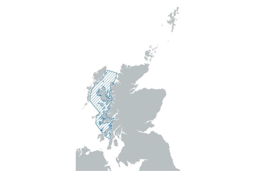
Special Area of Conservation
Area: 13,814km2.
Established 2018.
Protected feature of interest: Harbour porpoise (Phocoena phocoena)
Summary of SAC conservation objectives
The site contributes to maintaining favourable conservation status by ensuring there is no significant risk from injury or death, distribution is maintained by avoiding significant disturbance and the condition of supporting habitats and the availability of prey are maintained.
North-east Lewis

Nature Conservation Marine Protected Area
Area: 907km2
Established: December 2020
Protected feature of interest: Risso's dolphin (Grampus griseus)
Sea of the Hebrides
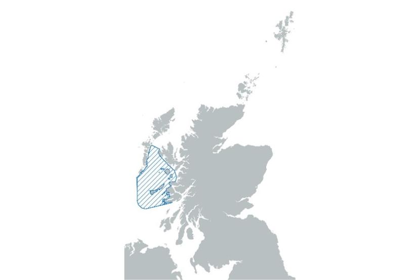
Nature Conservation Marine Protected Area
Area: 10,039km2
Established: December 2020
Protected feature of interest: Minke whale (Balaenoptera acutorostrata)
Southern Trench

Nature Conservation Marine Protected Area
Area: 2,398km
Established: December 2020
Protected feature of interest: Minke whale (Balaenoptera acutorostrata)
Summary of NCMPA conservation objectives
The site seeks to conserve favourable condition by ensuring there is no significant risk from injury or death, access to resources provided by the MPA that support various life stages are conserved, distribution is maintained by avoiding significant disturbance and the structure, function, distribution and extent of any supporting features are conserved.
Once an MPA has been established, continued and consistent Site Condition Monitoring (SCM) efforts are required to provide evidence to enable assessment of the site feature(s) condition and change over time; report on whether the sites are meeting their Conservation Objectives; and support the provision of management advice at the individual site and wider MPA network scale, as summarised in the Scottish Marine Protected Areas Monitoring Strategy (Marine Scotland, 2024; hereafter the ‘Scottish MPA Monitoring Strategy’). For mobile species such as cetaceans, this has resulted in the development of a Scottish mobile species monitoring programme, to support delivery of the Scottish MPA Monitoring Strategy. This programme consists of species- or group-specific monitoring plans, including plans for the monitoring of cetaceans.
Historically, SCM activities focused on cetaceans have centred on collecting information on abundance, densities (number of individuals/km2) and/or distribution to understand population dynamics, enable detection of trends and generally underpin feature condition assessments to inform management decisions (JNCC, 2005). This type of monitoring relies on direct observation of animals, which is achieved through visual and/or passive acoustic survey approaches, abundance estimates, and demographic assessments based on photo-identification. Wider context (both within and outwith MPAs) is provided through comparison against abundance/density data collected at broader spatial and temporal scales, notably through ongoing survey efforts by environmental Non-Governmental Organisations (eNGOs) such as the Hebridean Whale and Dolphin Trust (HWDT), the Cetacean Research and Rescue Unit (CRRU) and Whale and Dolphin Conservation (WDC) across Scotland. At even larger scales, additional context is provided by activities such as the large-scale surveys undertaken at multi-year intervals under the Small Cetaceans in European Atlantic Waters and the North Sea (SCANS) survey programme (Hammond et al., 2002; 2013; 2021).
The legal basis of current monitoring activities around Scottish MPAs is provided by various regulations:
- Under the Habitats Regulations, once every 6 years Scottish Ministers must report to the Scottish Parliament on the conservation status of protected features, including on the ability of protected sites to contribute to maintaining the feature at, or restoring the feature to, Favourable Conservation Status (FCS). In addition, these Regulations also cover the establishment and subsequent condition monitoring of Special Areas of Conservation (SACs) such as the Moray Firth SAC for bottlenose dolphin and the Inner Hebrides and the Minches SAC for harbour porpoise (Figure 1).
- Similarly, the Marine (Scotland) Act 2010 calls for regular assessments of the state of Scotland’s seas, based on Scottish Marine Regions (SMRs; Moffat et al., 2021). In addition, this Act also includes a requirement to establish and monitor Nature Conservation Marine Protected Areas, such as the North-east Lewis NCMPA for Risso’s dolphin, and the Sea of the Hebrides and Southern Trench NCMPAs for minke whale (Figure 1).
- The OSPAR Convention (specifically Recommendations 2003/3 and 2010/2; OSPAR, 2003; 2010) calls upon Contracting Parties, including the UK, to establish an ecologically coherent OSPAR Network of Marine Protected Areas. In Scotland, existing SACs and NCMPAs have been designated as part of this network. Evaluation of how well the MPA network is functioning, through an established monitoring programme, is required as part of the OSPAR Joint Assessment and Monitoring Programme (JAMP).
In addition, several other legal instruments establish the significance of monitoring the marine environment more broadly:
- Under the Water Environment and Water Services (Scotland) Act 2003, the Scottish Environmental Protection Agency (SEPA) has a duty to monitor the status of the water environment, resulting in annual reporting requirements by Scottish Ministers to the Scottish Parliament. SEPA’s monitoring responsibilities include semi-enclosed Scottish coastal waters such as the Minch and inner Moray Firth, as well as out to 3 nm from shore elsewhere, thereby encompassing all or portions of the cetacean-focused SACs and MPAs mentioned previously (Figure 1).
- The Marine Strategy Regulations 2010 (as amended) require Scottish Ministers to establish a monitoring programme to work towards achieving 'Good Environmental Status' in marine waters, and to report once every six years to the Scottish Parliament.
The requirement to undertake monitoring of Scottish MPAs’ continuing ability to function in support of the features for which they were established is therefore an established process underpinned by various pieces of legislation. In fulfilling this requirement for Scottish MPAs, the historical focus by NatureScot and others has been on directly monitoring the feature’s continued presence, density and/or abundance through repeated dedicated survey efforts, as part of SCM. In the context of Scottish cetacean MPAs, much of this feature monitoring is currently undertaken by eNGOs and academic institutions. A summary of ongoing ‘direct’ monitoring efforts associated with cetaceans in Scottish waters, many of which are undertaken within cetacean MPAs, is provided in Annex 1 (Table A1.1) of this report. Such direct monitoring approaches involve periodic dedicated surveys during which visual and/or passive acoustic observations of animals are collected, involving mobile platforms (observers on vessels, potentially towing hydrophone arrays), observations from fixed locations (shore-based sighting surveys, moored passive acoustic monitoring) or a combination of the two, depending on the specific study. These observational data are then used to underpin a wide range of assessments, including on abundance and density (either relative or absolute), on spatiotemporal heterogeneity in distribution, as well as on individual identification (photo-ID catalogues), long-term health evaluations and life histories (e.g., on growth, reproduction and survival rates). A particular example where such monitoring activities directly feed into SCM is provided by the monitoring activities undertaken by SMRU and UALFS, on behalf of NatureScot, of the Moray Firth SAC’s bottlenose dolphin population (Annex 1, Table A1.1). Similarly, the long-term observational datasets collected by eNGOs were vital in supporting the establishment of the Inner Hebrides and the Minches SAC (HWDT), and the Sea of the Hebrides (HWDT), North-east Lewis (WDC) and Southern Trench NCMPAs (CRRU; Figure 1). These ‘direct’ observations are thus fundamental to our present-day understanding of the conservation status of cetaceans in Scottish waters; their continued collection therefore provides a crucial element in the long-term management of these species as part of the Scottish MPA Monitoring Strategy.
However, by concentrating monitoring efforts solely on observing the cetaceans themselves, there is a risk that information on the underlying marine ecosystem that supports the continued presence of these species, and the various human activities occurring there that might impact them in some manner, is not adequately considered as part of status assessments. Considering a wider range of environmental and human activity parameters would provide additional information about the marine ecosystem, identify and improve understanding of drivers of population change, identify potential issues before they affect population parameters etc. Direct monitoring of cetaceans also presents a particular challenge due to inherent logistical complexities and high costs of monitoring animals that are highly mobile, difficult to observe, often occur far from land, and may only occur in Scottish waters at relatively low densities (e.g., Risso’s dolphin). As a result, obtaining sufficient observational data, particularly further offshore, in winter and/or at night may be difficult, complicating a robust assessment of how well the MPAs are performing in terms of their ability to continue to support cetacean features.
For these reasons, there is currently increased interest within NatureScot to develop a more strategic, holistic Scottish monitoring mobile species programme for cetaceans and other long-lived, wide-ranging species that are difficult to monitor directly, such as basking shark (Cetorhinus maximus) and flapper skate (Dipturus intermedius). In addition to direct feature monitoring, such a monitoring programme would also encompass aspects of ecosystem health, such as prey availability and intensity of anthropogenic pressures, rather than solely focusing on feature-specific metrics. By providing a better understanding of why and how animals are using identified areas of importance over time, any cetacean monitoring plan under such a programme would provide crucial information on overall habitat quality and thereby on the condition of the MPAs. Specifically, this approach would inform to what extent these MPAs continue to fulfil their function in ensuring favourable condition of the cetacean features for which they were established.
Since collection of such metrics will potentially involve expertise and resources outwith those traditionally involved with direct cetacean monitoring, it is important that any future ecosystem health monitoring plan for cetaceans be developed and integrated with other existing direct (regulatory) monitoring or data collection activities of cetaceans and their habitats, to share costs, avoid duplication of effort, and improve coordination.
Project aims
The main aim of this study was to identify a suite of relevant metrics to use for monitoring ecosystem health (habitat condition and anthropogenic pressures), using pressure-state relationships (linking observed feature condition [‘state’] to intensities and distributions of human activities which cause pressures on the feature or their supporting habitats) relevant to conservation and management of cetacean MPAs. The study was undertaken in several steps, summarised under the following three Work Packages (WPs):
WP1: A review of the literature to summarise current understanding of the ecology and conservation status of the four Scottish cetacean species under review in this study, including evidence gaps.
WP2: A review of potential metrics to evaluate overall utility for monitoring habitat quality and pressures, prioritised based on the following factors: specificity, ease of measurement, data availability, resource requirements, and wider ecological relevance.
WP3: Summarising WP2 outcomes into formal recommendations, including considering potential high-level resource implications of integrating proposed metrics into a holistic monitoring programme.
This work involved an evaluation of currently available data sources and consideration of issues such as complexities in data collection and analysis, relative cost, suitability and potential impact of monitoring various environmental characteristics and human activities. Ultimately, the present report provides a series of recommendations regarding monitoring metrics which, if implemented, would contribute to the development of a more holistic approach to cetacean monitoring in Scottish Territorial Waters, as part of the Scottish mobile species monitoring programme.
Work package 1: Literature review
A summary of population characteristics, critical habitat usage (a term widely used in the context of protected site conservation objectives to refer to habitat supporting breeding, feeding, and other key lifecycle behaviours of protected features), prey resource requirements and key pressures/threats has been provided for the four cetacean species under review in the present report, based on a review of the publicly available scientific and grey literature. From this exercise, it is apparent that the four species described here are quite different, in terms of abundance, distribution, residency, habitat requirements and sensitivity to particular pressures. It is also evident that various significant data gaps still remain, primarily in relation to foraging ecology, prey abundance and distribution, and the degree of spatiotemporal overlap with human activities that are known or suspected to negatively impact these species in Scottish waters. These data gaps have underpinned the subsequent selection process for novel metrics focusing on environmental factors and/or human marine activities associated with certain pressures.
Summary of abundance, critical habitat usage, prey resource requirements and key anthropogenic pressures/threats relevant for the four cetacean species considered in this report
Harbour porpoise
Abundance/distribution/population structure across Scotland (cf. Gilles et al., 2023)
Harbour porpoises are the most commonly observed cetacean in Scottish waters and can be found year-round throughout inshore waters. The density of porpoises off the west coast is amongst the highest in Europe (Embling et al., 2010; Booth et al., 2013), which directly led to the designation of the Inner Hebrides and the Minches SAC in 2016.
Critical habitat usage
Harbour porpoises on the west coast of Scotland show a consistent preference for waters between 50 and 150 metres and highly sloped areas (Booth et al., 2013).
The Inner Hebrides and the Minches SAC has been identified as providing good foraging habitat and may also be used for breeding and calving. Seabed habitat that is used by prey species sandeel and herring are important to consider in the context of critical porpoise habitat as local prey depletion could have impacts (Marubini et al., 2009).
Tidal-stream environments on the west coast of Scotland are often used by harbour porpoise (Benjamins et al., 2017).
Prey resource requirements
Because of their small body size, porpoises are considered to be particularly dependent on year-round proximity to food (Wisniewska et al., 2016). Their distribution and body condition is strongly linked to the availability and energy density of their prey. Sandeel, Atlantic herring, sprat and whiting are key prey species (Ransijn, Booth and Smout, 2019).
Key pressures / threats (cf. NatureScot, 2024)
- Pollution
- Entanglement in fishing gear
- Removal of prey species through commercial fishing
- Climate-change driven change in prey presence and abundance
- Underwater noise
- Mortality via bottlenose dolphin interactions and grey seal predation
Key data gaps
- There are significant uncertainties in terms of spatiotemporal distribution and abundance of prey available for porpoises, largely due to lack of fisheries survey effort for these species (sandeels, herring, sprat) in many areas.
- In other parts of their range, juvenile porpoises are known to rely on gobies and other small benthic fish species; their significance in Scotland remains poorly understood.
- Importance of local habitat features on harbour porpoise ecology is not well understood.
- Extent of spatiotemporal overlap and interactions with marine industries (fisheries, offshore energy, aquaculture etc.), and resulting impacts and population-level consequences, remain poorly understood.
- There is a general lack of understanding of the relationships between existing Management Units, and on long-range movements.
Bottlenose dolphin
Abundance/distribution/population structure across Scotland (cf. Gilles et al., 2023)
Bottlenose dolphins are a resident species in Scotland and can be seen throughout inshore waters (Cheney et al., 2013). There are three known groups of bottlenose dolphins; the Coastal East Scotland population (also ranging into northeast English waters) and the Sound of Barra and Inner Hebrides Communities on the west coast (Cheney et al., 2013; van Geel, 2016). Current understanding of these last two communities, in terms of the number of animals using these areas, as well as their year-round residency and long-term site-fidelity, is still limited, and the most recent assessment of UK bottlenose dolphin management units does not yet formally differentiate them (IAMMWG, 2023). Population estimates for the Coastal East Scotland dolphins indicate this population is growing in size (Arso Civil et al., 2021; Cheney et al., 2024) and that their range has expanded southward into northeast England (Ellis et al., 2023).
Critical habitat usage
Inshore waters close to coastlines, around headlands and in bays. Animals in the Coastal East Scotland population, at least, often display a topographical preference for deep narrow channels with strong tidal flows (which are known to attract/aggregate fish).
Prey resource requirements
Opportunistic feeders, bottlenose dolphins can adapt their foraging strategies to local conditions and food sources. The species is known for its diverse diet, including a variety of benthic and pelagic fish species (notably gadoids and salmonids; Santos et al., 2001; Plint et al., 2023) as well as crustaceans and cephalopods.
Key pressures / threats (cf. NatureScot, 2024)
- Pollution
- Entanglement in fishing gear
- Removal of prey species (commercial fishing)
- Climate-change driven change in prey presence and abundance
- Underwater noise
Key data gaps
- Some evidence of foraging specialisation (Plint et al., 2023) but the importance of particular prey species remains poorly understood.
- There is a general lack of information on trends in abundance and distribution of prey species.
- The extent of spatiotemporal overlap and interactions with marine industries (fisheries, offshore energy, aquaculture, porta and harbours etc.), and resulting impacts and population-level consequences, remain poorly understood.
- Health condition assessments are dependent upon limited data from strandings and visual observations.
- Population structure appears more complex than previously considered e.g., connectivity within Scottish west coast, between east and west coasts, and recently observed long-range movements along the east coast (Hoekendijk et al., 2021).
Risso’s dolphin
Abundance/distribution/population structure across Scotland (cf. Gilles et al., 2023)
Risso’s dolphins are recorded year-round in Scotland with higher densities found off North-east Lewis since at least 1933 (Paxton et al., 2014; Weir et al., 2019; Waggitt et al., 2020; Hodgins et al., 2024), which led to the designation of the site as an NCMPA in 2020. Boat-based photo-identification surveys showed a minimum of 117 animals recorded in the North-east Lewis MPA with some individuals demonstrating high levels of site fidelity (Weir et al., 2019; Hodgins et al., 2024). Observations of individuals showing morphological traits consistent with hybridisation with bottlenose dolphins have also been observed in this area (Hodgins et al., 2014; van Geel et al., 2022b).
Critical habitat usage
The species appears to have a preference for steep seabed habitat – deep shelf waters or deep waters close to land i.e., around east Lewis. However, the species has also been repeatedly observed in shallower waters in several of the bays in this area (N. Hodgins, pers. comm. 2024). North-east Lewis MPA has been identified as a potential calving and nursery area (Weir et al., 2019).
Prey resource requirements
In Scotland, the main prey are cephalopods, primarily octopus (Eledone cirrhosa), squid (Loligo sp.), and sepiolids, but fish species and crustaceans are also taken (Blanco et al., 2006; Macleod et al., 2014). Risso’s dolphins are thought to generally feed more at night when their prey is more active (benthic octopods/sepiolids) and/or migrates towards the surface (pelagic squids and fish). However, foraging behaviour has been repeatedly recorded during daylight hours within the North-east Lewis MPA (N. Hodgins, pers. comm. 2024). Little is known about the degree to which Risso’s are able to respond to reductions in availability or quality of their prey, e.g., via switching to other prey resources or moving to other areas (e.g., further offshore). The observed dominance of cephalopods in their diet may indicate a limited ability to switch prey species.
Key pressures / threats (cf. NatureScot, 2024)
- Pollution
- Entanglement in fishing gear
- Removal/displacement of prey species (commercial fishing, dredging)
- Climate-change driven change in prey presence and abundance
- Underwater noise
Key data gaps
- Many questions remain regarding foraging ecology and the extent to which foraging, particularly for E.cirrhosa, occurs within the North-east Lewis MPA (MacLeod et al., 2014).
- Information on spatiotemporal distribution of prey, particularly E.cirrhosa, in relation to benthic habitat features at different spatial scales would inform understanding of habitat use by Risso’s dolphins.
- Extent of spatiotemporal overlap and interactions with marine industries (fisheries, offshore energy, aquaculture etc.), and resulting impacts and population-level consequences, remain poorly understood. There is observational evidence of displacement of individual Risso’s dolphins in response to fishing activity (N. Hodgins, pers. comm. 2024).
Minke whale
Abundance/distribution/population structure across Scotland (cf. Gilles et al., 2023)
Minke whales can be frequently seen in coastal waters around Scotland between April and October with some present in the region through the winter months (Anderwald et al., 2007; Hebridean Whale and Dolphin Trust, 2018). A total of 308 individuals with permanent identifiable features were catalogued off the west coast between 1990 and 2020 (Hebridean Whale and Dolphin Trust, 2023) and 263 identification records for minke whales were collated off the east coast over 26 years (K. Robinson CRRU, pers. comm., 2022).
Critical habitat usage
Minke whales feed mainly in shallower water over the continental shelf and regularly appear around shelf banks and mounds or near fronts where zooplankton and fish are concentrated at the surface. Paxton et al. (2014) suggests seafloor topography, depth (40-50m), SST (10-12c) and chlorophyl are factors defining minke habitat preference / influencing distribution. Studies on the west coast have also shown sediment type is a significant predictor of whale presence, and minke whale distribution changes during the year to correlate with the availability of sandeel, herring and sprat (Macleod et al., 2004; Anderwald et al., 2012). Critical habitat used by key prey species, such as sandeel, herring and sprat, are important to consider in the context of critical minke habitat as local prey depletion could have impacts. Differing habitat partitioning and feeding specialisms of juveniles vs. adults has been proposed (Robinson et al., 2023).
Prey resource requirements
Presence of minke whales in Scottish coastal waters in summer months is closely linked to prey distribution. Minke whales have a varied diet. Sandeels form the bulk of their diet, alongside herring, sprat, haddock, saithe, whiting and small cod, as well as krill and other zooplankton (Pierce et al., 2004).
Key pressures / threats (cf. NatureScot, 2024)
- Collision with vessels
- Entanglement in creel ropes and accidental bycatch in fishing nets is the primary cause of death for minke whales in Scotland (MacLennan et al., 2020; MacLennan et al., 2021; Leaper et al., 2022).
- Persistent underwater noise which overlaps with their hearing range may interrupt key life-cycle activities such as feeding and breeding, causing them to avoid or even abandon certain areas (Cholewiak et al., 2018; van Geel et al., 2022a).
- Minke whales are sensitive to any reduction in availability of prey, which could result through competition from other species, fishing pressure, or climate change.
- Commercial whaling in the North Atlantic targets minke whales which are part of the same population seen in the waters around Scotland.
Key data gaps
- There are significant uncertainties in terms of spatiotemporal distribution and abundance of prey available for minke whales, largely due to lack of fisheries survey effort for these species (sandeels, herring, sprat) in many areas.
- Extent of spatiotemporal overlap and interactions with marine industries, especially commercial fisheries, offshore energy (underwater noise) and marine traffic (collisions, disturbance), and resulting impacts and population-level consequences, remain poorly understood.
- Questions remain around minke whale population (sub)structure in the north Atlantic, and on how long-range movements might influence minke whale presence in Scottish waters (IAMMWG, 2015).
Work package 2: Metric development and assessment
Methods
The main goal of this study was to identify a series of metrics suitable for monitoring ecosystem health (habitat condition and anthropogenic pressures) relevant to conservation and management of cetacean MPAs, in conjunction with ongoing ‘direct’ feature monitoring activities. This was achieved by bringing together a group of experts in cetacean health, ecology and management to discuss potential metrics and identify priorities.
Workshop
A full-day workshop was held at Inverness College, UHI, on January 23, 2024 (hereafter referred to as ‘the workshop’), which sought to canvass opinions across the breadth of organisations involved in cetacean research and assessment in Scotland and the wider UK as to what types of metrics would be useful in assessing habitat condition and anthropogenic pressures on the cetacean species within and outwith designated MPAs in Scottish waters (Figure 1). A total of 22 representatives of government agencies, academic institutions, and eNGOs attended the workshop, either in person or on-line. A full list of workshop participants is included in Annex 2 (Table A2.1).
To facilitate discussion, workshop attendees were organised into four subgroups, each associated with a broad Theme. Each subgroup consisted of 5-6 workshop attendees, including in-person and online attendees. The four subgroup Themes were defined as follows:
- Animal Health: the focus of this Theme was to identify metrics describing direct or indirect impacts on the health of animals, including body condition, infectious disease rates and parasite burdens.
- Ecology: the focus of this Theme was to identify metrics that related to the broader web of ecological connections involving the species of interest, mostly related to the animals’ diet but also considering wider ecological issues (e.g., competition, predation).
- Changes to Physical Environment: the focus of this Theme was to identify metrics that described changes in the animals’ physical environment, including underwater noise, loss of/damage to physical environmental features supporting the species of interest, and broader environmental trends driven by global climate change.
- Direct Impacts: the focus of this Theme was to identify metrics that explicitly described impacts resulting in death or injury of animals (e.g., entanglement in fishing gear, collisions with ships).
The Themes were defined in this way to encourage consideration of a wide range of potential metrics on the day of the workshop and to make optimal use of the breadth of knowledge and experience available among the workshop attendees.
Following an introductory plenary session, the four subgroups were tasked to consider multiple different metrics within the wider context of their Theme. Creative, outside-the-box thinking was encouraged to capture different metrics, including ones that might not currently be collected but could be further developed with additional investment of effort and/or resources.
Workshop participants were encouraged to consider potential metrics in relation to two broad criteria, specifically ‘Usefulness’ (i.e. how suitable is this metric in terms of its ability to inform about ecosystem health? Can the metric easily be applied to multiple regions and/or species?) and ‘Practicality’ (i.e. How difficult is it to implement data collection for this metric? Does the metric require significant amounts of effort and/or resources to monitor?). These criteria were not intended to be used in a quantitative manner by the workshop participants but sought to capture some of the multifactorial complexities surrounding the use of these proposed metrics, to enable NatureScot to decide on which metrics to select for immediate prioritisation versus further optimisation prior to being implemented.
The metric development exercise was facilitated by use of the online Google Jamboard application, which allowed subgroup participants to place proposed metrics within a virtual online space defined by two axes of Usefulness and Practicality (Figure 2). Moreover, Google Jamboard allowed participants to organise metrics according to whether they were mainly applicable to individual species, rather than applicable to all cetacean species under consideration.
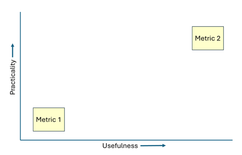
Figure 2. Example of Jamboard figure used to organise proposed metrics in the workshop according to both Usefulness and Practicality.
Click for a full description
A graph displaying a hypothetical arrangement of Metrics ranked according to Usefulness (x-axis) and Practicality (y-axis). Two boxes, representing Metrics 1 and 2, are placed within the space encompassed by the two axes. Metric 1 is placed towards the bottom left of the graph, signifying its limited Usefulness and Practicality, whereas Metric 2 is placed towards the top right of the graph, signifying its high Usefulness and Practicality, as assessed during the workshop. In the present example, Metric 2 was deemed to be significantly more useful, as well as more practical to implement, than Metric 1, and placed accordingly.
As illustrated in Figure 2, the two-axis approach in Google Jamboard allowed workshop participants the opportunity to organise their proposed metrics spatially such that the ‘best’ metrics, in terms of perceived Usefulness and Practicality, should end up near the top right corner of the graph. More experimental approaches, or metrics that only informed tangentially about factors relevant to cetaceans, would score lower along one or both axes. It is worth reiterating that such metrics might still be useful under particular circumstances or could be useful in the future if developed further. The Google Jamboard notes from each subgroup, as developed during the workshop, have been included in Annex 3 (Figures A3.1-A3.8).
Review and prioritisation of metrics
Following the subgroup sessions, the results from each subgroup were discussed in a final plenary session at the workshop. Unfortunately, limited time was available for in-depth discussion of these proposed metrics at the event itself. To enable further discussion following the workshop, the subgroup lead team first undertook an in-depth appraisal of the various proposed metrics according to a bespoke traffic light scheme, developed in consultation with NatureScot (summarised in Table 1). The scheme incorporated several elements which were based on conversations with workshop attendees and NatureScot and which were intended to capture more granular information about the perceived current or future suitability of each metric as part of a holistic cetacean monitoring plan. This secondary assessment was intended to be qualitative rather than quantitative in nature, and no threshold values (e.g., relating to costs) were defined to distinguish between categories/colours. The different elements of the traffic light scheme were not ranked and were each considered independently for every proposed metric (Table 1). Where different subgroups had independently converged on the same metric during the workshop, the assessment outcomes were combined within the most appropriate Theme to avoid duplication, while ensuring that the discussions among both subgroups were accurately captured in the accompanying notes.
Workshop attendees were subsequently given the opportunity to review the metrics and their traffic light assessments and to suggest revisions. Importantly, during this stage all workshop attendees were also asked to independently score each proposed metric on a scale of 1-3 (where 1 = priority, 2 = high priority, 3 = immediate priority), according to their view of its ability to fulfil condition assessment of cetacean features and/or the MPA network, inform management effectiveness etc. To facilitate discussion, the various metrics suggested during the workshop were organised retrospectively under a series of broad topics:
- Cause of Death (generic)
- Entanglement/Bycatch/Commercial fishing
- Collision with Vessels
- Disturbance
- Underwater Noise
- Prey and Diet
- General Health
- Wider Ecology
Attendees were encouraged to score all the proposed metrics, although this was not a firm requirement e.g., in case of perceived lack of expertise in certain fields, or where the respondent held the view that particular metrics were less of a priority. These assessments were then aggregated by taking the average of the scores provided by workshop participants for each metric. Metrics with higher average scores (defined as >2) and low variation (standard deviation around average scores) were considered a higher priority. For ease of assessment, a basic division was implemented between metrics with standard deviations <0.5 (‘low’ SD, suggesting broad agreement among respondents) and metrics with standard deviations ≥0.5 (‘high’ SD, suggestive of divergent opinions among respondents).
Table 1 can be viewed as an Excel spreadsheet at the bottom of this page
Results
Workshop outcomes
The proposed metrics developed at the workshop have been organised by Theme in a series of tables (Tables 2–5). A brief description of each metric is provided, together with a summary assessment of potentially relevant data sources, comments provided during the workshop, the post-workshop traffic light assessments, and metric rankings. Screengrabs of the Google Jamboards that were used to aggregate these metrics during the workshop have been included in Annex 3 (Figures A3.1–A3.8).
A total of 11 out of 18 eligible workshop participants (61%, with NatureScot staff members excluded) provided feedback on metric rankings (Tables 2–5). This information was used to generate average rankings and standard deviations for each metric, to provide a general indication of which metrics were deemed to be the most immediate priority to implement, according to this cross-section of Scottish marine mammal researchers. Metrics which 1) received a high average ranking and 2) had a low standard deviation associated with this average (suggesting that most respondents were providing similar rankings) were considered the highest priority for inclusion in a future Scottish cetacean monitoring plan.
Table 2 can be viewed as an Excel spreadsheet at the bottom of this page
Theme 1: Animal Health: Summary of existing/potential data sources and relevant information
AH01: Frequency of observed marine debris at sea surface per unit time/effort
Existing/potential data sources:
- Ship-based visual survey data (HWDT, ORCA, SCANS)
- Aerial survey data (collected by e.g., HiDEF and APEM around offshore windfarms).
- SEPA may have data from inshore waters.
Relevant information/aspects to consider:
- Various marine pollution monitoring schemes around.
- Coverage uneven around Scotland, inshore vs offshore.
- Ease of Measurement is deemed Amber based on offshore survey platform needs.
AH02: Frequency of observed marine debris on beaches
Existing/potential data sources:
- Various beach-based survey programmes e.g., BeachTrack (SMASS), Beachwatch (MCS)
Relevant information/aspects to consider:
- Provides insight into what debris might have been at sea.
- Biased towards easily accessible beaches, hotspots of people.
- Expansion of projects needed, both spatially and temporally.
AH03: Frequency of marine debris (including microplastics) found inside stranded or bycaught animals
Existing/potential data sources:
- SMASS can provide data (NB currently little or no access to bycaught animals).
Relevant information/aspects to consider:
- Varying degrees of complexity depending on particle size considered.
- Ease of Measurement is Red when considering microplastics due to need for specialist knowledge and equipment, otherwise Green.
- Note potential issues about representativeness of strandings data, limited sample sizes for many species.
AH04: Contaminant screening: concentrations of POPs, heavy metals etc. from necropsies of stranded or bycaught animals
Existing/potential data sources:
- SMASS and SMRU collect and undertake analysis (or facilitate elsewhere; NB: currently little or no access to bycaught animals).
- Other data sources on contaminant levels in environment, prey could include CEFAS, Marine Directorate, SEPA etc.
Relevant information/aspects to consider:
- Ease of Measurement is Amber due to need for specialist knowledge and equipment.
- More information is needed about contaminant levels in cetacean prey species.
- Note potential issues about representativeness of strandings data, limited sample sizes for many species.
AH05: Contaminant screening: concentrations of POPs, heavy metals, toxins associated with HABs etc. from biopsies of live animals
Existing/potential data sources:
- SMASS, SMRU can undertake analysis (or facilitate elsewhere).
- Other data sources on contaminant levels in environment, prey could include CEFAS, Marine Directorate, SEPA etc.
Relevant information/aspects to consider:
- Not all samples are suitable.
- Note the elevated ethical concerns and licensing requirements surrounding tagging live animals.
- Samples are currently available, but limits on processing capacity preclude analysis.
- More information is needed about contaminant levels in cetacean prey species.
- Ease of Measurement is Amber due to need for specialist knowledge and equipment.
AH06: Severity of parasite burden found inside stranded or bycaught animals
Existing/potential data sources:
- SMASS routinely collects parasite data from stranded animals that are necropsied (NB currently little or no access to bycaught animals).
- Semi-quantitative metric of burden severity is given for each organ and an integrated pathological assessment of impact at the animal level.
Relevant information/aspects to consider:
- How does severity of parasite burden affect animals’ individual health and fitness?
- Difficult to assess population-level consequences.
- May require internal data evaluation before sharing across projects.
- Note potential issues about representativeness of strandings data, limited sample sizes for many species.
- Ease of Measurement is considered Amber due to need to develop molecular assays, otherwise Green.
- Wider Ecological Relevance is considered Amber due to parasite-host specificity
- Note potential issues about representativeness of strandings data, limited sample sizes for many species.
AH07: Severity of external parasite burden observed in the wild or found attached to stranded or bycaught animals
Existing/potential data sources:
- Observations through photo ID, visual surveys by HWDT (bottlenose dolphin, minke whale), AULFS (bottlenose dolphin), SAMS, WDC (Risso’s dolphin), CRRU (minke whale)
- SMASS routinely collects parasite data from stranded animals that are necropsied (NB: currently little or no access to bycaught animals).
Relevant information/aspects to consider:
- Links in with observations on skin lesions, infections etc.
- Likely to only be indicative of serious health issue when burdens are very high or impacting a significant (>25%) of population.
- Implications of presence of skin lesions etc. on individual health and population growth rates are unclear.
- Existing pictures may need reprocessing for this metric.
- Note potential links to climate change.
- Note potential issues about representativeness of strandings data, limited sample sizes for many species.
AH08: Infectious disease occurrence rates from necropsies of stranded or bycaught animals
Existing/potential data sources:
- SMASS routinely collects data from stranded animals that are necropsied (NB currently little or no access to bycaught animals).
Relevant information/aspects to consider:
- SMASS outsources some analysis to other partners.
- Link to UMEs, other potentially relevant pathogens (H5N1 avian flu etc.).
- Note that this metric is hard to implement but very important!
- Specificity may be Green depending on the pathogen involved.
- Ease of Measurement assigned as Amber due to need for specialist knowledge and equipment, but these already exist.
- Wider Ecological Relevance score might be Red depending on the risk of cross-species infection.
- Note potential issues about representativeness of strandings data, limited sample sizes for many species.
AH09: Mortality patterns: distribution, number of strandings per unit effort (if quantifiable) per year
Existing/potential data sources:
- SMASS collects these data based on strandings.
- Effort-weighted data may be difficult to obtain (but note BeachTrack app).
Relevant information/aspects to consider:
- Consider whether changes in reporting rates due to more effort, more awareness, more mortality or environmental change. Can BeachTrack app help?
- Overlay data with information on species’ abundance and distribution.
- Note potential issues about representativeness of strandings data, limited sample sizes for many species.
AH10: Cause of death (CoD), including changes over time and across species
Existing/potential data sources:
- SMASS collects these data based on strandings.
Relevant information/aspects to consider:
- Cause of death may not always be identifiable, depending on carcass condition. However, it is often possible to rule out potential factors, especially trauma cases from direct anthropogenic trauma and assess body condition even if the ultimate CoD is elusive (i.e. in live stranding cases).
- Ease of Measurement, Data Availability and Likely Additional Costs depend on cause of death.
- Wider Ecological Relevance score is Green, as relevant to identify emerging threats and enable cross-species comparisons.
- Note potential issues about representativeness of strandings data, limited sample sizes for many species.
AH11: Body condition (linked to animal resilience): Strandings data
Existing/potential data sources:
- 30 years of data available through SMASS (length, girth, photos).
Relevant information/aspects to consider:
- Need to integrate data to understand seasonal changes as proxy for resilience; this relationship will vary according to species.
- An opportunity to bring together strandings and photogrammetry data.
- Important to consider whether death was due to observed body condition or whether body condition is due to some other factor that led to death.
- This method indirectly informs on various factors that drive body condition.
- Note potential issues about representativeness of strandings data, limited sample sizes for many species.
AH12: Body condition (linked to animal resilience): observations of live animal (laser or drone photogrammetry)
Existing/potential data sources:
- Data are collected by AULFS and trialled by HWDT; current efforts are limited but could be expanded
Relevant information/aspects to consider:
- Provides assessment of growth rates, life stages, body condition, change over time.
- Scope currently limited.
- Can also contribute to better assessment of entanglement rates.
- An up-and-coming future approach.
AH13: Body condition: measurements of blubber thickness
Existing/potential data sources:
- SMASS can provide data on this metric.
Relevant information/aspects to consider:
- As this approach is limited to strandings, more information is needed to determine population-level applicability.
- Note potential issues about representativeness of strandings data, limited sample sizes for many species.
AH14: Body condition: Blubber composition (lipids)
Existing/potential data sources:
- SMASS can provide data on this metric.
Relevant information/aspects to consider:
- Seasonality has an impact, but more information is required.
- Ease of Measurement, Likely Additional Cost scores are Red due to need for specialist knowledge and equipment.
- Samples are currently available, but limits on processing abilities preclude analysis.
- Note potential issues about representativeness of strandings data, limited sample sizes for many species.
AH15: Age structure of population (teeth, body length, long term photo-ID studies, body length assessment via laser or drone photogrammetry)
Existing/potential data sources:
- Age determination data is being, or could be, collected (SMASS and SMRU).
- Photo-ID data are collected by various organisations (HWDT, AULFS, WDC).
- AULFS also collects photogrammetry data (mainly bottlenose dolphin) and this approach has been trialled by HWDT.
Relevant information/aspects to consider:
- Need to develop growth curves.
- Accuracy of body length measurements needs confirmation.
- Increasingly difficult for older animals.
- Ageing using teeth is a well-established method, but a capacity problem currently exists.
- A vital tool for long-term population management.
- Note potential issues about representativeness of strandings data, limited sample sizes for many species.
AH16: Age structure of population (molecular methods; DNA methylation etc.)
Existing/potential data sources:
- Not presently being collected.
Relevant information/aspects to consider:
- More detailed studies are needed.
- Note the elevated ethical concerns and licensing requirements surrounding sampling live animals.
- Costs likely to fall in near future as methods become more robust and widely applied.
- Ease of Measurement, Likely Additional Costs scores were assessed as Red due to need for specialist knowledge and equipment.
AH17: Pregnancy rates
Existing/potential data sources:
- Based on strandings data (SMASS).
- AULFS also collects UAV data (BND mainly).
Relevant information/aspects to consider:
- Most useful for species known or suspected to breed in Scottish waters.
- Potential for visual observations through drones (linked into body condition metrics described earlier).
- This metric will be highly species-specific.
- Note potential issues about representativeness of strandings data, limited sample sizes for many species.
AH18: Birth rates
Existing/potential data sources:
- Based on photographic observations (through photo-ID programmes; HWDT, WDC, AULFS etc.), including citizen science.
Relevant information/aspects to consider:
- Straightforward to measure if good views of known individuals can be obtained.
- Possibly question over reliability of the data without photographic evidence - dependent on experience.
- This metric will be highly species-specific.
AH19: Diet: rates of feeding activity per unit time (collected using PAM, tags etc.)
Existing/potential data sources:
- Existing PAM data (ECOMMAS/SPAN, COMPASS, AULFS etc.) could be reanalysed.
- Novel tag-borne devices (e.g., DTAGs or equivalent) could be used to observe feeding by tagged individuals.
Relevant information/aspects to consider:
- PAM analysis is complicated by difficulties in accurate species identification, group size estimation, and may only be able to indicate generalised foraging activity.
- Note the elevated ethical concerns and licensing requirements surrounding tagging live animals.
- Ease of Measurement score is assigned Red if involving tagging of live animals with DTAGs etc., due to complex systems required.
- Data analysis score is assigned Red due to data processing requirements.
AH20: Diet: rates of feeding activity per unit time (collected using visual observations)
Existing/potential data sources:
- Visual observations are available from HWDT, WDC, ORCA, SeaWatch etc.
Relevant information/aspects to consider:
- Potential for different interpretation of ‘feeding’ behaviour between different observers.
- Biased towards near-surface feeding activities.
- Observations will likely be limited to nearshore areas/low sea states.
- Ease of Measurement score has been assigned as Green when only considering feeding at the surface.
- Data analysis and Wider Ecological Relevance scores have been assigned as Amber due to need for additional analysis.
AH21: Diet: monitor seabird diet + breeding success as early warning of changes to prey base
Existing/potential data sources:
- Various groups (BTO etc.) have contributed to Marine Ecosystem Research Programme (MERP) seabird diet database.
Relevant information/aspects to consider:
- Check for frequency of MERP database updates?
- How close a match are seabird diets to cetacean diets, in terms of fish size, weight, energy content, distance from breeding sites where caught?
- Ease of Measurement, Data analysis, Likely Additional Costs scores depend on how much of an overlap exists between seabird and cetacean diets.
- Unclear how much of an impact this metric might have?
AH22: Genetic structure of population(s) to inform on management units, inbreeding, population size etc.
Existing/potential data sources:
- Full genetic sequencing can be done from biopsies and skin samples currently being held by SMASS.
Relevant information/aspects to consider:
- Unclear whether this can inform on use of MPA by >1 population?
- Samples are collected by SMASS, but not routinely analysed due to lack of resources.
- Note potential issues about representativeness of strandings data, limited sample sizes for many species.
Table 3 can be viewed as an Excel spreadsheet at the bottom of this page
Theme 2: Ecology: Summary of existing/potential data sources and relevant information
EC01: Diet composition: Stomach content analysis
Existing/potential data sources:
- SMASS has access to stomach content data from strandings, which allow for assessment of diet immediately prior to death.
- Metagenomics (eDNA) on stomach/intestinal contents can provide information where diagnostic hard parts (otoliths etc.) are unavailable.
Relevant information/aspects to consider:
- Focus on presence and relative importance of different prey species (number of prey items, total mass, frequency across populations), seasonal fluctuation, variation across life stages.
- West coast data currently limited and as-yet unpublished; mainly based on strandings rather than bycaught animals (last published in-depth analysis was by Santos et al., 2007).
- Note risk of regurgitation from strandings (leads to empty stomachs).
- Note relevance to population models (e.g., iPCoD, DEPONS).
- Important to consider prey switching across age classes, seasonal and spatial differences.
- Note potential bias due to complete digestion of some prey.
- Ease of Measurement was scored as Amber due to need for specialist expertise in hard part (otoliths etc.) identification, metagenomics.
- Samples are currently available, but processing is limited by available resources.
- Note potential issues about representativeness of strandings data, limited sample sizes for many species.
EC02: Diet composition: Fatty acid analysis
Existing/potential data sources:
- SMASS has access to tissue samples, which allow for assessment of diet across different timescales (weeks to months prior to death).
Relevant information/aspects to consider:
- Ease of Measurement, Likely Additional Cost scores were assessed as Red due to need for specialist knowledge and equipment.
- Note potential issues about representativeness of strandings data, limited sample sizes for many species.
EC03: Diet composition: Stable isotope analysis
Existing/potential data sources:
- SMASS has access to tissue samples, which allow for assessment of diet across different timescales (weeks to months prior to death).
Relevant information/aspects to consider:
- Note Plint et al. (2023).
- Stable isotope work is done whenever possible, but no funding is currently available to do this as standard.
- Ease of Measurement, Likely Additional Cost parameters scores were assessed as Red due to need for specialist knowledge and equipment.
- Note potential issues about representativeness of strandings data, limited sample sizes for many species.
EC04: Visual observations of foraging activity (anecdotal/citizen science): individual, regional, seasonal variation in prey consumed
Existing/potential data sources:
- HWDT, WDC, CRRU and others (tourboat operators) will have this information (Whale Track app).
- Most appropriate for bottlenose dolphin, minke whale
Relevant information/aspects to consider:
- Subjective if fish are not also observed.
- Most feeding occurs underwater and is therefore not observable.
- Lack of coverage offshore.
- Method less suitable for harbour porpoise, Risso’s dolphin.
- Likely Additional Cost score was assessed as Amber due to need for time for analysis.
EC05: Quality of prey (in terms of calorific value, contaminant loads etc.)
Existing/potential data sources:
- Unclear whether these data are presently being collected for relevant species or trophic levels (some work was recently done in the Moray Firth by Exeter University and SMRU Consulting under the UKRI PrePARED project).
- Food Standards Scotland may have some information for commercial species?
Relevant information/aspects to consider:
- Important to also evaluate non-commercial species.
- This metric is perhaps most useful as part of a broader assessment of energetics (food intake vs. energy expenditure).
- Important to understand risk of anthropogenic impacts on prey species (notably pollution, to evaluate biomagnification risks in cetaceans).
- (By)catch in commercial fisheries can assist in providing prey fish samples in certain areas.
EC06: Prey occurrence/abundance/diversity at local scales: BRUVs, systematic diver surveys, fish trapping, echosounder surveys etc.
Existing/potential data sources:
- This work could be undertaken by citizen scientists from local communities. Very locally this is being done (Shetland, Arran, Moray Firth), but a wider roll-out using a consistent approach would be needed.
Relevant information/aspects to consider:
- Important to collect data throughout the year.
- Likely to be mainly focused on inshore areas.
- Important to understand risk of anthropogenic impacts on prey species.
- Community groups require training and financial support. This training, and subsequent data integration from multiple groups, needs to be centrally coordinated.
EC07: Prey occurrence/abundance/diversity at wider scales: commercial fish surveys, echosounder surveys, and fishery observer programme outcomes
Existing/potential data sources:
- Some data collection efforts are ongoing within different sectors, e.g., the Scottish pelagic industrial data collection programme for stock assessment (SPFA, 2022).
- Fisheries data are available through Marine Directorate.
Relevant information/aspects to consider:
- Ongoing pelagic and demersal fish survey programmes are the primary source of information on stock status and trends and will likely continue to provide the bulk of available information on cetacean prey availability across Scottish waters for the foreseeable future.
- Current fish survey efforts may not provide data at appropriate spatial resolutions or cover particular locations and periods that are relevant to cetacean-prey interactions.
- It is important to check for representativeness and ease of accessing data.
- Not all relevant species are caught by commercial fisheries.
- Data are not available for all species; current survey effort is limited or absent in many parts of Scotland, especially along the west coast and in nearshore waters.
EC08: Spatiotemporal diversity, relative abundance of prey using eDNA methods
Existing/potential data sources:
- Studies are being undertaken in various parts of the world, not yet consistently in Scotland.
Relevant information/aspects to consider:
- Methodology is well understood; some questions remain in relation to data interpretation.
- Particularly relevant where no stock assessments are currently being undertaken, to provide baseline information.
- Note Boyce et al. (2024) for a recent, relevant Scottish example.
EC09: Disturbance of fish habitat (notably sandeels and Atlantic herring)
Existing/potential data sources:
- Data on fishing effort etc. are available from Marine Directorate (VMS + AIS) and are also submitted to ICES.
- General vessel traffic data (& associated noise outputs) may be made available from Marine Directorate.
- EMODNet provides aggregate vessel density data.
- St Andrews SIFIDS project (2018-2020)
- MD/Marine Noise Registry for planned/consented/realised construction activities and other noise producing activities.
- Analysis of broadband PAM data (e.g., ECOMMAS/SPAN, COMPASS).
Relevant information/aspects to consider:
- Scale of aggregation of fishing effort data (particularly those datasets provided to ICES) may be too coarse for detailed spatiotemporal evaluation of fishing impact.
- This metric also links directly to habitat of cetaceans.
- Ease of Measurement, Data Analysis and Likely Additional Cost scores may need to be Red given potential need for additional analysis.
- This metric links directly to management.
EC10: Primary productivity as indicator of habitat quality for pelagic fish preyed upon by cetaceans
Existing/potential data sources:
- WestCOMs and other hydrodynamic models (e.g., MD Scottish Shelf Model)
- Satellite telemetry data (e.g., Copernicus).
Relevant information/aspects to consider:
- Relationship between primary productivity and pelagic fish not always clear at spatial and temporal scales relevant to cetacean MPAs.
- Consideration of time lags as impacts move up the food web. Further work is needed to strengthen this metric.
- Ease of Measurement score was assessed as Green, assuming that relevant satellites, survey platforms etc. are available.
- Data may not be available at spatiotemporal resolutions relevant for MPAs.
- Utility depends on the strength of linkages from phytoplankton to fish species.
EC11: Determining functional use of areas within MPAs
Existing/potential data sources:
- Requires in-depth surveys to collect behavioural data.
- Can involve visual surveys, PAM, and/or tagging approaches.
Relevant information/aspects to consider:
- Why do animals use certain parts of the MPA in certain ways? What are ‘push’ vs. ‘pull’ factors?
- This will be difficult to achieve without significant investment in both time and resources.
- When considering tagging approaches, note requirements to carefully consider additional complexities (Home Office licensing, ethical issues), as well as small sample sizes.
- Specificity score was assessed as Red, as this metric will be both site- and species-specific.
- Ease of Measurement Score was assessed as Red, as this metric will be both site- and species-specific. Also the score depends on exactly what method is used.
- Data availability score was assessed as Red, with the possible exception of bottlenose dolphins in Moray Firth SAC, Risso’s dolphins in North-east Lewis NCMPA
EC12: Level of competition with other predator species (marine mammals, seabirds, tuna etc.)
Existing/potential data sources:
- Various groups (BTO etc.) have contributed to MERP seabird diet database.
- Seal diet data can be collected from scats etc. during breeding/ moult (SMRU); data from other species much less available (strandings, bycatch data; SMASS).
Relevant information/aspects to consider:
- Spatiotemporal overlap will be an important initial indicator.
- How close a match are seabird diets to cetacean diets, in terms of fish size, weight, energy content, distance from breeding sites where caught?
- Consider future changes due to climate change.
- There is a need to link to metrics on stomach contents, stable isotopes, behavioural observations of feeding.
- Patchy data availability, and analysis is needed for comparisons.
EC13: Level of predation pressure (by sharks, killer whales, grey seals) on cetaceans: number of observations, abundance of predators (seasonal) across MPAs
Existing/potential data sources:
- Regular surveys (HWDT, WDC etc.) may provide evidence of killer whale presence, grey seal predation events.
- Observations can be collected from the general public through citizen science incl. Whale Track app.
- Information on shark prevalence in Scottish waters may come from recreational anglers and fishery observers.
- Predation evidence may also come from strandings (SMASS).
Relevant information/aspects to consider:
- Predator abundance and distribution at sea are poorly understood in most areas around Scotland.
- Lots of collection and amalgamation of data will be needed; data are likely to be anecdotal rather than collected systematically.
- Likely Additional Cost score was assessed as Red, mainly due to large time requirements to locate/amalgamate the data.
- Wider Ecological Relevance score was assessed as Amber, as predation is important to understand as a factor when considering long-term population changes but is unlikely to be amenable to direct management.
- Note potential issues about representativeness of strandings data, limited sample sizes for many species.
Table 4 can be viewed as an Excel spreadsheet at the bottom of this page
Theme 3: Changes to Physical Environment: Summary of existing/potential data sources and relevant information
PE01: Soundscape – non-impulsive noise (e.g., shipping, aquaculture, fishing, military activity)
Existing/potential data sources:
- Several PAM networks in Scotland (SPAN, WDC, HWDT, AULFS).
- Offshore industry data (especially offshore wind farms) represent another potential source of information.
- Noise data are already being collected by HWDT, AULFS, MD, and others, but are not always analysed.
Relevant information/aspects to consider:
- There is a need for sampling control sites, as well as sites of industrial activity.
- Long-term access to data is important, especially from industry, which has historically been difficult.
- Consider designating minimum PAM calibration standards.
- Useful to understand seasonal variation in cumulative noise levels, attributable to shipping and other anthropogenic sources. Some degree of analytical skill required.
- Ease of Monitoring score was assessed as Red due to need for specialist knowledge and equipment.
- Most industry PAM data is not yet being shared; important metadata may be missing; no overarching framework currently exists to archive large PAM datasets.
- PAM coverage is currently insufficient inside MPAs.
- This metric will produce outputs relevant for MSFD and OSPAR.
PE02: Soundscape – impulsive noise (e.g., seismic surveys, pile driving, military sonar, explosions, acoustic deterrent devices)
Existing/potential data sources:
- Several PAM networks in Scotland (SPAN, WDC, HWDT, AULFS).
- Offshore industry data (especially OWF) represent another potential source of information.
- Impulsive noise data are aggregated in the MNR dataset.
Relevant information/aspects to consider:
- Important to consider how data are to be stored and made accessible, as well as any current barriers (link to the JNCC MNR).
- To explicitly measure impacts of a known sound source, proper planning of a dedicated survey is essential.
- This metric will produce outputs relevant for MSFD, OSPAR and the MNR.
PE03: Effects of meteorology: stability of weather over time/in future, driving changes to prey distribution, habitat structure
Existing/potential data sources:
- Met Office or equivalent organisations will be able to provide access to relevant meteorological data (e.g., storminess), water temperature etc.
- Existing climate models can be used to forecast future change.
Relevant information/aspects to consider:
- Our collective knowledge of how these large-scale climate events impact cetaceans is still limited.
- Need to arrange access to meteorological datasets, incorporate them into habitat models, species distribution models etc., as this metric may be less useful on its own.
- Likely Additional Costs were assessed as Amber due to the need for relevant expertise, computational power to run these models.
- This metric is focused on the future, rather than on current status assessments.
PE04: Topographic and/or bathymetry changes to seabed morphology, rugosity, habitat classification (focused on acute impacts)
Existing/potential data sources:
- Some industry data related to change (e.g., dredging, FOW construction, subsea cabling) will be available.
Relevant information/aspects to consider:
- Bathymetric data are widely collected as part of various industrial activities; accessing and amalgamating them may be difficult due to access issues and costs.
- Data on sediment characteristics are patchy and may be rare inshore.
- There is currently a lack of knowledge of how these impacts affect fish, let alone subsequently cetaceans.
PE05: Topographic and/or bathymetry changes to seabed morphology, rugosity, habitat classification (focused on long-term stability)
Existing/potential data sources:
- Photogrammetry and eDNA could be used to confirm presence and persistence of benthic communities over time. Both these techniques are being adopted for active use by research institutes, consultancies etc.
Relevant information/aspects to consider:
- It is unclear how frequently benthic habitats around Scotland are currently being surveyed in appropriate detail to inform about habitat changes relevant to cetaceans.
- There is currently a lack of knowledge of how these impacts affect fish, let alone subsequently cetaceans.
- Ease of Measurement score was assessed as Amber as specialised knowledge is needed.
PE06: Strength and persistence of ecologically relevant oceanographic features (e.g., fronts)
Existing/potential data sources:
- Satellite-derived environmental data (e.g., SST, Chl-a) may be available.
- Oceanographic modelling can inform about strength and persistence (fronts, seasonal stratification etc.).
Relevant information/aspects to consider:
- It is unclear if front mapping currently occurs on a regular basis.
- Understanding the relevance of fronts to cetaceans may require additional research.
- Any monitoring would need to occur on both sides of frontal systems to increase understanding of their ability to modulate prey density.
- Likely Additional Costs score was assessed as Red, as specialised expertise will be required.
PE07: Chemical pollution (events-based)
Existing/potential data sources:
- SEPA may have data for inshore waters.
Relevant information/aspects to consider:
- This needs to be linked with oceanographic data to understand likely spread over time.
- Current coverage (and therefore data availability) is likely to be reasonable inshore, but poor in offshore waters, resulting in an Amber assessment of the Data Availability score.
PE08: Contaminant levels in sediment/water samples
Existing/potential data sources:
- SEPA has data from inshore waters.
- Bathing water data are collected in summer at certain places (concentrated on bathing beaches)
Relevant information/aspects to consider:
- Monitoring typically occurs inshore; results are therefore likely mainly relevant for coastal species e.g., bottlenose dolphins rather than minke whale.
- Current understanding of resulting health effects of contaminant exposure on marine mammals is not complete for all substances.
- Ease of Monitoring, Data Availability and Likely Additional Costs scores were assessed as Amber, as offshore sampling is not currently done routinely across all areas.
Table 5 can be viewed as an Excel spreadsheet at the bottom of this page
Theme 4: Direct Impacts: Summary of existing/potential data sources and relevant information
DI01: Number of confirmed cetacean mortalities linked to bycatch or entanglement within/adjacent to MPAs per unit time
Existing/potential data sources:
- SMASS stranding records.
- Bycatch monitoring data (SMRU, Defra).
- Surveys of fishers (questionnaires) such as done through the SEA project (MacLennan et al., 2021).
Relevant information/aspects to consider:
- Reporting rate can be tailored to suit requirements (e.g., yearly, quarterly).
- Various forms of Remote Electronic Monitoring (REM), including cameras, are being rolled out across various fleets in Scotland and could in theory provide insights into bycatch rates – but further development is likely to be required.
- Note potential issues about representativeness of strandings data, limited sample sizes for many species.
DI02: Assessment of external evidence of bycatch in stranded animals that are not collected for necropsy
Existing/potential data sources:
- SMASS stranding records contain this information, where available.
Relevant information/aspects to consider:
- SMASS could increase focus on recognising signs of bycatch, entanglement during volunteer training. This could be based on existing protocols developed elsewhere (e.g., Cornwall Wildlife Trust Marine Strandings Network Bycatch Evidence Evaluation Protocol (BEEP); Crosby et al., 2022).
- Note potential issues about representativeness of strandings data, limited sample sizes for many species.
DI03: Proportion of live animals showing evidence of injury through entanglement, collision etc. (e.g., gear attached, scarring)
Existing/potential data sources:
- Photo-ID catalogues held by HWDT (minke whale, bottlenose dolphin, Risso’s dolphin), WDC (Risso’s dolphin), CRRU (minke whale) and AULFS/SMRU (bottlenose dolphin). British Divers Marine Life Rescue also hold photographs from reports of entangled animals (multiple species). Suitable data are being collected (i.e. HWDT data on minke whales assessed in Maclennan et al., 2021); Analysis still needed for other datasets.
Relevant information/aspects to consider:
- This metric is unlikely to be appropriate for harbour porpoise.
- This metric is unlikely to inform about the origins of the material causing the entanglement.
DI04: Density/distribution of static fishing gear (number of units/km2)
Existing/potential data sources:
- Suitable data are already being collected by HWDT (cf. the SEA project; Maclennan et al., 2021) and WDC.
Relevant information/aspects to consider:
- Risk is directly proportional to amounts of rope in the water column, but observed number of buoys may be hard to relate to length of attached creel fleet.
- Available data are specific to certain areas, mainly along the west coast with some recent inshore data from the east coast.
- More time and effort are needed for analysis of existing data.
- Consistency across organisations is needed to facilitate integration of data across larger areas.
DI05: Information on static gear usage (e.g., average, maximum soak times) and distribution, e.g., through surveys of fishers (questionnaires)
Existing/potential data sources:
- Building on the SEA project (involving University of Glasgow, SMASS, HWDT, WDC and others, which has engaged with fishers since 2018; MacLennan et al., 2021)
Relevant information/aspects to consider:
- Surveys require considerable time investment for proper conversations but could yield vital information and improve relations with fishing communities.
- Understanding how much gear is deployed and lost per annum may help to quantify entanglement risk from lost gears.
DI06: Information on spatiotemporal distribution of commercial fishing activity (based on vessel movement)
Average number of vessel movements within a grid cell (0.05×0.05 degree grid, similar to existing >12 m vessel effort data submitted to ICES) for each fishing metier/fleet.
Existing/potential data sources:
- Vessels >12 m are currently monitored using VMS. In future, movements of vessels <12 m will be monitored using similar technology (I-VMS). Implementation of this system is anticipated in the next few years, building on recent efforts in England. Anonymised VMS data are made available by MD and ICES.
- Vessels >15 m are required to operate AIS. Vessel AIS data are available for purchase from Marine Traffic and are also being independently collected by e.g., Scottish Vessel Project; Heriot-Watt University, HWDT, WDC.
- Vessel density data, including of several specific fishing fleets, is available from EMODNet.
Relevant information/aspects to consider:
- Parts of the Scottish fishing fleet (particularly smaller vessels fishing static gear such as creels) are not presently covered by either VMS or AIS. As a result, there is currently a particular absence of spatial effort data for these types of gear, which can pose a particular bycatch/entanglement risk.
- Data Availability score of Red assumes that introduction of I-VMS may pose initial problems, requiring time to resolve. I-VMS will also likely ramp up over time rather than be introduced all at once.
- Likely Additional Costs were assessed as Red due to the need for organising/sharing existing and future data with NatureScot.
DI07: Observations of marine debris with entanglement potential, ghost nets etc., ideally effort-weighted for quantification
Existing/potential data sources:
- Citizen science data through e.g., phone apps (BeachTrack, ScrapBook) and SeaSearch observations.
- Data collected through e.g., HWDT surveys, MD surveillance, HiDef and APEM survey flights; observations by Ghost Fishing UK; Defra/JNCC.
- Records of gear loss from commercial fishers (held by MMO and MD).
- Purchase rates of new fishing gear to replace lost stock may be available from manufacturers.
Relevant information/aspects to consider:
- Some of these data already exist, but greater focus on its collection and analysis would help.
- Ease of Measurement and Data Availability scores depend on where surveys occur. Beach surveys are easiest and most frequently undertaken, whereas surveys for ghost nets on the seabed are hardest, especially in deeper offshore waters (but may pose a greater current threat).
DI08: Risk of interactions with vessels (based on vessel movement patterns), mapped against species distribution
Existing/potential data sources:
- AIS on larger vessels may be used as proxy, in combination with land-and sea-based visual surveys (Scottish Vessel Project; HWDT, WDC Shorewatch).
- Also consider traffic associated with offshore renewables.
- JOMOPANS shipping database may be useful.
- MD holds vessel information.
- Vessel density information available through EMODNet.
Relevant information/aspects to consider:
- Need to collect regularly (e.g., monthly).
- Consider satellite vessel movement data – note the SATURN project.
- Ease of Measurement score was assessed as Amber, as processing costs are not trivial.
- Data Availability score was assessed as Red, as AIS data would need to be sourced (HWDT and Scottish Vessel Project are collecting AIS data).
- Likely Additional Costs score was assessed as Red, as AIS and satellite data are usually expensive to obtain.
DI09: Interactions between recreational vessels and cetaceans that result in disturbance, as part of systematic effort-based cetacean surveys
Existing/potential data sources:
- WDC Shorewatch collect these data.
- Information may also be available from Police Scotland and SSPCA.
- Reporting of disturbance incidents on social media (Instagram, Tripadvisor, FaceBook, X etc.) by the public, per unit time.
Relevant information/aspects to consider:
- NB: Density of vessels does not always directly link to disturbance.
- Potential issues with reliability and consistency. This metric may be subjective.
- Unclear how accessible these data sources are (note legal implications when dealing with what might constitute wildlife crime), and/or how precise in terms of location, description of disturbance etc.
- Heavily biased towards areas where many people go.
- Only WDC is actually collecting these kinds of data at the moment. It is important to liaise with them regarding the details of these data.
DI10: Occupation rates of marinas, rental rate of paddle boards etc., to capture wider levels of marine tourism and thereby indirectly inform on disturbance probability
Existing/potential data sources:
- Data would need to be provided by commercial operators or independent observers.
Relevant information/aspects to consider:
- It is unclear how these kinds of data might be collected consistently and integrated into an assessment, as it is unclear how these numbers relate to actual disturbance.
- GDPR might be an issue.
- Data collection is likely to be highly localized; impact thresholds unclear.
- This approach may also be relevant for other marine megafauna (e.g., seals, seabirds) in particular circumstances.
DI11: Wildlife tourboat activities: Density/distribution of tourboat activity in relation to animal encounter rates per unit effort
Existing/potential data sources:
- Data would need to be provided by commercial operators or independent observers (e.g., by using the Whale Track, Seawatcher, ORCA Oceanwatcher apps).
Relevant information/aspects to consider:
- Are boats targeting the same animals sequentially?
- Widespread buy-in from operators required to be useful.
- Operators use their own systems or Whale Track app, which may require resources to integrate into a usable dataset.
DI12: Wildlife tourboat activities: Changes to animal encounter rates per unit effort as a result of repeat exposure to tourboats
Existing/potential data sources:
- Data would be provided by commercial operators or independent observers, e.g., by using the Whale Track, Seawatcher, Orca Oceanwatcher apps).
- Some data may be collected using shore-based observations (e.g., WDC Shorewatch).
Relevant information/aspects to consider:
- Widespread buy-in from operators required to be useful.
- Additional analysis of existing data is needed.
- Encounter rates may vary for a multitude of reasons outwith tourboat densities/behaviour.
DI13: Information on vessel sizes, types, lengths, densities, distribution, movement patterns, and speeds (average and maximum) to identify areas of high collision probability
Existing/potential data sources:
- Vessels >12 m are currently monitored using VMS. In future, movements of vessels <12 m will be monitored using similar technology (I-VMS). Implementation of this system is anticipated in the next few years, building on recent efforts in England. Anonymised VMS data are made available by MD and ICES.
- Vessels >15 m are required to operate AIS. Vessel AIS data are available for purchase from Marine Traffic and are also being independently collected by e.g., Scottish Vessel Project; Heriot-Watt University, HWDT, WDC.
- Also land-based visual surveys (Scottish Vessel Project; WDC Shorewatch, Sea-Watch, HWDT Whale Track) and sea-based surveys (HWDT AIS and visual observations).
Relevant information/aspects to consider:
- This can link to noise disturbance metrics.
- There is a need to consider expansion of current monitoring approaches into new areas.
- Consider what monitoring rates would be appropriate (Year-round, daily hourly?).
- Wider Ecological Relevance score was assessed as Red assuming the metric is focussed on collision explicitly.
- It is not yet known how important this problem (vessel strike) is in Scotland.
DI14: Reporting rates of actual collision events (incl. insurance claims), ideally effort-weighted
Existing/potential data sources:
- ORCA: Data on actual occurrences would be provided by commercial operators or independent observers.
- SMASS collates records on cases where ship strike was confirmed or suspected, and reports these to the IWC as part of their efforts to collate ship strike information globally (also note Robbins et al., 2022).
- Analysis of photo-ID data (i.e. HWDT, AULFS, WDC) may provide evidence of ship strikes having occurred.
Relevant information/aspects to consider:
- Consider whether GDPR might be an issue.
- Past collision events inferred from photo-ID observations may have taken place outside Scottish waters.
- This metric may also be relevant to basking sharks
- Reports may be available for larger boats, but possibly not for smaller ones.
- This metric is not currently being monitored in Scotland.
DI15: Number of near miss collision events, ideally effort-weighted
Existing/potential data sources:
- Relevant data are already being collected by ORCA from ferries and cruise ships.
Relevant information/aspects to consider:
- Extrapolation of survey outcomes to other vessel types is needed for a complete picture.
- This metric may also be relevant to basking shark.
DI16: Frequency and potential causes of cetacean Unusual Mortality Events (UMEs) per year
Existing/potential data sources:
- Are these events becoming more frequent over time? SMASS collects data on this topic.
- Wind direction data can be obtained from Met Office. This and other environmental metrics need to be built into measure of effectiveness of SMASS’ monitoring strategy.
Relevant information/aspects to consider:
- There is a particular focus on MPA-relevant cetacean species, both inside and outside/adjacent to MPAs. Factors affecting UMEs include wind direction and physical environment, which have a significant influence on number of carcasses of animals that die at sea that make it to the beach.
- Causes of UME could be external to SAC/MPA.
- Ease of Measurement score was assessed as Green if the metric only focuses on UME frequency of occurrence. The investigation into potential causes is more involved.
- Wider Ecological Relevance score was assessed as Amber, but this depends on the cause of the UME.
DI17: UME of any non-cetacean species, farmed in aquaculture – potentially linked to HABs, infectious disease outbreaks or pollution events
Existing/potential data sources:
- This information should be available for cultivated species from Aquaculture Scotland and/or SEPA.
- Other cases may be picked up by media or through professional networks.
Relevant information/aspects to consider:
- A consistent approach for collecting this information is required.
DI18: UME of wild non-cetacean species (of any kind)
Existing/potential data sources:
- Some pathogens are closely monitored (H5N1 Avian flu), others less so.
Relevant information/aspects to consider:
- Better surveillance for infectious disease in marine mammals and other species (e.g., avian flu) is urgently needed from a conservation, public and livestock health perspective.
- A new monitoring scheme may be required to coordinate across different pathogens.
DI19: Levels of toxins produced by harmful phytoplankton species in water samples
Existing/potential data sources:
- Collected in coastal locations (notably around aquaculture sites) and aggregated at Hab Reports.
Relevant information/aspects to consider:
- More information on appropriate toxicity thresholds for cetaceans are needed (this may be available from the USA and elsewhere where HABs have historically been a greater problem).
- Geographic bias (monitoring efforts are currently concentrated along west coast, Shetland, in line with aquaculture sector).
- There is a need to review the detailed monitoring methods to better understand complexities.
- Current monitoring activity is strongly associated with inshore aquaculture, so offshore data are typically lacking.
DI20: Level of HAB toxins found in stranded cetaceans, other marine mammals
Existing/potential data sources:
- SMASS collects samples but these are not yet routinely tested.
Relevant information/aspects to consider:
- Data gaps exist on East coast due to lack of aquaculture.
- Need to consider whether current samples might allow a review of whether levels have increased over time.
- Note potential issues about representativeness of strandings data, limited sample sizes for many species.
DI21: Sea surface temperature (SST) increase as a proxy for HAB likelihood of occurrence
Existing/potential data sources:
- SST data are readily available (MD, Copernicus etc.)
- Consider likely increase in average SST over time due to climate change, as well as occurrence of marine heatwaves.
Relevant information/aspects to consider:
- Input from external experts (e.g., Aquaculture Scotland, SAMS) will be needed.
- It is important to continue to investigate the predictive power of using SST to understand long-term impacts of climate change through HABs and other pathways.
Evaluating metrics for prioritisation
When comparing the metrics’ average rankings and associated variability based on the responses by workshop attendees, several outcomes were apparent. First, a set of 11 proposed metrics were consistently ranked as an immediate priority by those workshop attendees who responded (average ranking of >2.5, SD <0.5; Table 6).
| Broad topic | Metric | Average ranking (SD) |
|---|---|---|
| Cause of Death | AH10: Cause of death (CoD), including changes over time and across species. | 2.9 (0.30) |
| Entanglement/Bycatch/ Commercial fishing | DI01: Number of confirmed cetacean mortalities linked to bycatch or entanglement within/adjacent to MPAs per unit time | 3.0 (0.00) |
| Entanglement/Bycatch/ Commercial fishing | DI04: Density/distribution of static fishing gear (number of units/km2). | 3.0 (0.00) |
| Entanglement/Bycatch/ Commercial fishing | DI03: Proportion of live animals showing evidence of injury through entanglement, collision etc. (e.g., gear attached, scarring). | 2.7 (0.47) |
| Entanglement/Bycatch/ Commercial fishing | DI05: Information on static gear usage (e.g., average, maximum soak times) and distribution, e.g., through surveys of fishers (questionnaires) | 2.7 (0.47) |
| Underwater Noise | PE01: Soundscape – non-impulsive noise (e.g., shipping, aquaculture, fishing, military activity) | 2.9 (0.32) |
| Underwater Noise | PE02: Soundscape – impulsive noise (e.g., seismic surveys, pile driving, military sonar, explosions, acoustic deterrent devices) | 2.9 (0.32) |
| Prey and Diet | EC06: Prey occurrence/abundance/diversity at local scales: BRUVs, systematic diver surveys, echosounder surveys etc. | 2.7 (0.47) |
| Prey and Diet | EC03: Diet composition: Stable isotope analysis | 2.7 (0.48) |
| General Health | AH18: Birth rates | 2.9 (0.33) |
| General Health | AH12: Body condition (linked to animal resilience): observations of live animal (laser or drone photogrammetry). | 2.7 (0.48) |
A second set of 11 metrics received comparably high rankings (average ranking >2.5) from the respondents, but with greater variability around the average (a ‘high’ SD score of ≥0.5; Table 7). This suggested some divergence of opinion in terms of the perceived prioritisation of these metrics amongst those workshop participants who responded. This may have been caused by the relatively small number of participants who returned rankings for the metrics and could be particularly relevant for some of the metrics that require specialised expertise and equipment (e.g., stable isotope analysis). Given the essentially arbitrary designation of a 0.5 threshold between ‘high’ and ‘low’ SD scores, the ‘high’ SD scores ≥0.5 should therefore not be taken to mean that these metrics are less of a priority in terms of implementation, and metrics listed in Tables 6 and 7 should both be considered as immediate priorities for implementation.
| Broad topic | Metric | Average ranking (SD) |
|---|---|---|
| Cause of Death | DI16: Frequency and potential causes of cetacean Unusual Mortality Events (UMEs) per year. | 2.6 (0.50) |
| Entanglement/bycatch/ commercial fishing | DI06: Information on spatiotemporal distribution of commercial fishing activity (based on vessel movement): average number of vessel movements within a grid cell (0.05×0.05-degree grid, similar to existing >12m vessel effort data submitted to ICES) for each fishing metier/fleet. | 2.7 (0.67) |
| Entanglement/bycatch/ commercial fishing | DI02: Assessment of external evidence of bycatch in stranded animals that are not collected for necropsy. | 2.7 (0.50) |
| Prey and Diet | EC01: Diet composition: Stomach content analysis. | 2.8 (0.60) |
| Prey and Diet | EC09: Disturbance of fish habitat (notably sandeels and Atlantic herring): scale of prey species habitat loss due to climate change, commercial fishing, dredging, vessel noise, naval training exercises, coastal construction, cable deployment and other activities. | 2.7 (0.65) |
| Prey and Diet | EC07: Prey occurrence/ abundance/diversity at wider scales: commercial fish surveys, echosounder surveys, and fishery observer programme outcomes. | 2.6 (0.50) |
| Prey and Diet | EC02: Diet composition: Fatty acid analysis | 2.6 (0.52) |
| General Health | AH11: Body condition (linked to animal resilience): Strandings data | 2.6 (0.50) |
| General Health | AH17: Pregnancy rates | 2.6 (0.52) |
| General Health | AH05: Contaminant screening: concentrations of POPs, heavy metals etc. from necropsies | 2.6 (0.69) |
| Wider Ecology | EC11: Determining functional use of areas within MPAs | 2.7 (0.71) |
The 22 metrics in Tables 6-7 largely fall within a small number of broad topics, indicating that these topics are of overriding concern among members of the Scottish cetacean research community. These results strongly suggest that any future Scottish cetacean monitoring plan should incorporate metrics such as the ones proposed here that explicitly address questions around 1) interactions with fisheries, 2) underwater noise, 3) presence/abundance/diversity of prey species, 4) causes of mortality and 5) aspects of animal health more generally. It is worth noting that many of these metrics pertain, directly or indirectly, to pressures driven by human activities which potentially are susceptible to management.
Most of the remaining metrics were ranked somewhat lower in terms of priority (average ranking 1.5 – 2.5 inclusive, typically with an SD score ≥0.5); they have been summarised in Table 8 below. Several possible reasons for these rankings were identified:
- Some of the proposed metrics are comparatively novel or require more research to be applied more widely, e.g., using molecular methods to determine the age structure of a population (AH16), using eDNA to characterise prey fish assemblages (EC08), or measuring toxins associated with harmful algal blooms (DI19, DI20).
- Other proposed metrics refer to pressures that have not historically received much attention in a Scottish monitoring context, e.g., those relating to collisions with vessels (DI08, DI13, DI14, DI15) and disturbance (DI09, DI11, DI12).
- Some metrics might be more difficult to carry out on a large enough scale to ensure they are representative of the wider population or species (e.g., EC04, DI09).
- Finally, some proposed metrics were thought to have a narrower focus than others within the same broad topic (e.g., presence of microplastics found inside stranded animals; AH03).
This suggests that metrics receiving a lower priority ranking might require some degree of additional methodological development or careful scoping to become fully integrated into a holistic cetacean monitoring plan. This topic will be developed in more detail below (see also Annex 4).
| Broad topic | Metric | Average ranking (SD) |
|---|---|---|
| Cause of Death | AH09: Mortality patterns: distribution, number of strandings per unit effort (if quantifiable) per year. | 2.5 (0.69) |
| Cause of Death | DI17: UME of any non-cetacean species, farmed in aquaculture – potentially linked to HABs, infectious disease outbreaks or pollution events. | 1.7 (0.65) |
| Cause of Death | DI18: UME of wild non-cetacean species (of any kind) | 1.7 (0.65) |
| Entanglement/Bycatch/ Commercial fishing | DI07: Observations of marine debris with entanglement potential, ghost nets etc., ideally effort-weighted for quantification. | 2.2 (0.87) |
| Entanglement/Bycatch/ Commercial fishing | AH01: Frequency of observed marine debris at sea surface per unit time/effort. | 1.7 (0.65) |
| Entanglement/Bycatch/ Commercial fishing | AH02: Frequency of observed marine debris on beaches. | 1.8 (0.75) |
| Collision with Vessels | DI13: Information on vessel sizes, types, lengths, densities, distribution, movement patterns, and speeds (average and maximum) to identify areas of high collision probability. | 2.3 (0.90) |
| Collision with Vessels | DI14: Reporting rates of actual collision events (incl. insurance claims), ideally effort-weighted. | 2.3 (0.90) |
| Collision with Vessels | DI15: Number of near miss collision events, ideally effort-weighted. | 1.7 (0.79) |
| Disturbance | DI08: Risk of interactions with vessels (based on vessel movement patterns), mapped against species distribution. | 2.3 (0.79) |
| Disturbance | DI11: Wildlife tourboat activities: Density/distribution of tourboat activity in relation to animal encounter rates per unit effort. | 2.0 (0.63) |
| Disturbance | DI12: Wildlife tourboat activities: Changes to animal encounter rates per unit effort because of repeat exposure to tourboats. | 1.7 (0.67) |
| Disturbance | DI09: Interactions between recreational vessels and cetaceans that result in disturbance, as part of systematic effort-based cetacean surveys. | 1.6 (0.53) |
| Prey and Diet | EC05: Quality of prey (in terms of calorific value, contaminant loads etc.) | 2.3 (0.48) |
| Prey and Diet | AH19: Diet: rates of feeding activity per unit time (collected using PAM, tags etc.) | 2.3 (0.82) |
| Prey and Diet | EC04: Visual observations of foraging activity (anecdotal/citizen science): individual, regional, seasonal variation in prey consumed. | 2.1 (0.83) |
| Prey and Diet | EC08: Spatiotemporal diversity, relative abundance of prey using eDNA methods. | 2.0 (0.77) |
| Prey and Diet | AH20: Diet: rates of feeding activity per unit time (collected using visual observations) | 1.8 (0.79) |
| Prey and Diet | AH21: Diet: monitor seabird diet + breeding success as early warning of changes to prey base | 1.6 (0.70) |
| General Health | AH15: Age structure of population (teeth, body length, long term photo-ID studies, body length assessment via laser or drone photogrammetry). | 2.5 (0.53) |
| General Health | AH03: Frequency of marine debris (including microplastics) found inside stranded or bycaught animals. | 2.5 (0.82) |
| General Health | AH08: Infectious disease occurrence rates. from necropsies of stranded or bycaught animals. | 2.5 (0.82) |
| General Health | AH22: Genetic structure of population(s) to inform on management units, inbreeding, population size etc.) | 2.3 (0.83) |
| General Health | DI20: Level of HAB toxins found in stranded cetaceans, other marine mammals. | 2.2 (0.63) |
| General Health | AH13: Body condition: measurements of blubber thickness. | 2.2 (0.63) |
| General Health | AH06: Severity of parasite burden found inside stranded or bycaught animals. | 2.2 (0.87) |
| General Health | AH14: Body condition: Blubber composition (lipids) | 2.1 (0.57) |
| General Health | AH07: Severity of external parasite burden observed in the wild or found attached to stranded or bycaught animals. | 1.9 (0.70) |
| General Health | AH05: Contaminant screening: concentrations of POPs, heavy metals, toxins associated with HABs etc. from biopsies of live animals. | 1.9 (0.83) |
| General Health | DI19: Levels of toxins produced by harmful phytoplankton species in water samples. | 1.8 (0.79) |
| General Health | DI21: Sea surface temperature (SST) increase as a proxy for HAB likelihood of occurrence | 1.8 (0.79) |
| General Health | PE08: Contaminant levels in sediment/water samples | 1.8 (0.79) |
| General Health | AH16: Age structure of population (molecular methods; DNA methylation etc.). | 1.7 (0.82) |
| General Health | PE07: Chemical pollution (events-based) | 1.6 (0.70) |
| Wider Ecology | PE05: Topographic and/or bathymetry changes to seabed morphology, rugosity, habitat classification (focused on long-term stability) | 1.9 (0.78) |
| Wider Ecology | PE06: Strength and persistence of ecologically relevant oceanographic features (e.g., fronts) | 1.9 (0.88) |
| Wider Ecology | PE04: Topographic and/or bathymetry changes to seabed morphology, rugosity, habitat classification. Event-based (focused on acute impacts) | 1.8 (0.79) |
| Wider Ecology | EC10: Primary productivity as indicator of habitat quality for pelagic fish preyed upon by cetaceans. | 1.5 (0.69) |
Finally, a small number of proposed metrics was widely considered to be a lower priority by respondents, at least for now (Table 9). This included metrics relating to interactions with other top predators (e.g., EC12, EC13). Several respondents indicated that they had ranked them in this way because they considered these metrics to be difficult to implement in a practical way, since these kinds of interactions would be largely outwith direct management control.
| Broad topic | Metric | Average ranking (SD) |
|---|---|---|
| Disturbance | DI10: Occupation rates of marinas, rental rate of paddle boards etc., to capture wider levels of marine tourism and thereby indirectly inform on disturbance probability. | 1.2 (0.40) |
| Wider Ecology | PE03: Effects of meteorology: stability of weather over time/in future, driving changes to prey distribution, habitat structure. | 1.4 (0.70) |
| Wider Ecology | EC12: Level of competition with other predator species (marine mammals, seabirds, tuna etc.). | 1.3 (0.48) |
| Wider Ecology | EC13: Level of predation pressure (by sharks, killer whales, grey seals) on cetaceans: number of observations, abundance of predators (seasonal) across MPA. | 1.1 (0.32) |
The workshop feedback results indicated a clear hierarchy among different topics in terms of prioritisation. Metrics that addressed known impacts leading to mortality, injury or disturbance (e.g., entanglement, underwater noise) and/or addressed questions about animal health or diet by means of well-established methods were prioritised over metrics that:
- were focused on less well-quantified impacts (e.g., collision, disturbance).
- related to impacts where the potential for active management intervention was limited (e.g., certain pollutants; predation rates, competition with other predators).
- tackled broader ecological questions (e.g., predation rates, competition with other predators).
- relied on methods that were still under development.
This hierarchy suggests a desire within the Scottish marine mammal research community for a future Scottish cetacean monitoring plan that initially focuses on a limited number of key topics that can be reliably measured and can serve as the basis for management action to optimise conservation outcomes. If such a holistic plan were to be implemented, it should nonetheless be subject to periodic review to ensure the selection of monitoring metrics remains appropriate for each species and/or MPA and take into account the latest knowledge and methodological developments (i.e., allowing additional metrics to be incorporated in the future). Furthermore, any such review should include the possibility to enhance/expand the scope of the monitoring plan over time to incorporate the monitoring of any emerging threats identified through ongoing research.
Work package 3: Evaluation and implementation
Outcomes of the metrics evaluation process
The metrics proposed in this study (Tables 2 – 5) were developed during a one-day workshop attended by a representative cross-section of the marine mammal research community in Scotland and, to a lesser extent, the wider UK. As such, the metrics collectively are intended to address data gaps relating to 1) the quality of the cetacean habitat within and outwith MPAs and 2) the distribution and intensity of human activities that could generate negative impacts, as perceived by the marine mammal research community and in line with existing understanding of the sensitivity of cetaceans to various pressures (e.g., through the updated Feature Activity Sensitivity Tool, or FeAST; NatureScot, 2024). The list of proposed metrics presented here, while not exhaustive, therefore highlights specific areas where the Scottish marine mammal research community considers that additional monitoring efforts are required. While several proposed metrics can be implemented with comparatively limited effort, others will require additional development to enable widespread implementation.
A multi-staged approach towards developing a comprehensive cetacean monitoring plan is therefore recommended, which would allow for rapid implementation of some metrics, while enabling further development of some of the metrics identified by workshop participants as lower than ‘immediate priority’ but deemed by regulators as worthy of further consideration. The present report should therefore be considered a step in the process of identifying a suitable series of metrics to enhance monitoring of habitat quality and human activities in and among MPAs for cetaceans in Scottish waters.
Implementation
The workshop format facilitated agreement on identification and characterisation of potential metrics, encouraging outside-the-box, blue-sky thinking. Perhaps unsurprisingly, there was less consensus about implementation, including resource requirements. While workshop attendees were well informed about cetacean-related data collection efforts, they acknowledged their potential collective lack of awareness of other relevant monitoring programmes (of human activities, environmental factors, and other ecosystem components) that did not have a cetacean focus. Many workshop attendees noted that the absence of experts in other fields such as fisheries science, oceanography, and marine chemistry, at the workshop complicated efforts to inform about the actual implementation with regards to practicality, availability and cost of many proposed metrics. Workshop attendees made a concerted effort to identify ongoing monitoring programmes in other disciplines that could potentially provide data to underpin the metrics proposed here (Tables 2-5), but a more in-depth review was outside the scope of this study. A thorough assessment of ongoing survey and monitoring efforts across Scottish Government agencies, academic institutions and eNGOs is therefore needed to determine whether any ongoing data collection efforts, e.g., to underpin Scotland’s Marine Assessment (SMA2020; Moffat et al., 2021), could be used to enable assessment of any of the proposed metrics.
Tables 2-5 summarise current understanding of whether data relevant to the proposed metrics are already being collected through existing monitoring schemes (see also Annex 1; Table A1.1). Some of these monitoring schemes, such as the HWDT surveys, have an explicit focus on ‘direct’ observational monitoring of cetaceans but also record a wide range of data on concurrent environmental conditions and/or human activities, which may require additional processing to become useful to NatureScot’s cetacean monitoring plans. Conversely, other ongoing monitoring activities (e.g., relating to presence and impacts of HABs) are not currently used routinely outwith the Scottish aquaculture sector but could potentially provide useful information to NatureScot, at least for specific cetacean MPAs. In addition, more in-depth analysis of existing datasets could provide significant new insights through improved integration and analysis. Finally, minor adjustment to ongoing programmes may be possible to collect additional data to support reporting on these metrics. There is a real opportunity to complement and/or make better use of data that are already being collected alongside direct monitoring efforts (Annex 1; Table A1.1), to assess species condition and ecosystem health, as well as monitor trends, changes and emerging threats. This process needs to also consider whether ongoing monitoring intensities and spatiotemporal distributions are appropriate to enable the overarching monitoring goals to be achieved. Optimising the use of these data sources and collection programmes will likely require additional investment, as many of the workshop participants expressed concern that their respective teams were already stretched to capacity and would struggle to deliver additional outputs to future monitoring plans without further support.
Any implementation of indirect ecosystem health monitoring based on the metrics proposed above as part of a holistic cetacean monitoring plan will require additional investment in terms of time and resources. The magnitude of these costs is likely to vary considerably between different metrics, as illustrated by the outcomes of the traffic light assessments (Tables 2-5). In the absence of existing guidance on what monitoring levels might be required to meet specific objectives for cetacean MPAs, an in-depth evaluation of the full costs of implementing appropriate monitoring approaches for each proposed metric is beyond the scope of this study. In the absence of comprehensive costings, the metrics proposed in this study have been categorised qualitatively in terms of resources and effort required for effective implementation. Understanding of various current monitoring operations already being undertaken by researchers in Scotland and elsewhere provides an opportunity for preliminary evaluation of resource implications for particular kinds of sampling, analysis and/or data acquisition relevant to particular metrics that were deemed to be the highest priority by workshop participants. This has been initially expressed through the traffic light assessment scheme described above (Table 1), but can be expanded upon as follows:
- Some metrics are already being collected at appropriate scales and would require only limited alterations to data delivery and reporting processes to feed into a NatureScot cetacean monitoring plan.
- Some metrics are ‘hidden’ amongst existing datasets that are already being collected at appropriate scales and would require support for re-analysis of historic and current data to feed into a NatureScot cetacean monitoring plan.
- Some metrics are not presently assessed at appropriate scales/intensities to inform a monitoring plan due to a lack of resources, but the underlying information and expertise required to do so is available (e.g., analysis of existing tissue samples for contaminants, stable isotopes or fatty acids), suggesting that additional funding would enable the metric to be made useful for a NatureScot cetacean monitoring plan.
- Some metrics are not presently assessed at appropriate scales/intensities to inform a monitoring plan due to a lack of resources, and no mechanism for collecting the underlying data currently exists in Scotland, but the underlying science is well understood and established analytical tools are available. In these cases, new monitoring schemes may need to be developed, or existing non-cetacean monitoring schemes need to be expanded, to enable such metrics to be effectively integrated into a NatureScot cetacean monitoring plan.
- For some metrics, there is still a lack of understanding about the underlying science, a need for validation of novel methodologies and/or concerns about practical implementation which merit further research before proceeding with integrating such metrics into a NatureScot cetacean monitoring plan.
These categories are not always mutually exclusive and multiple categories may apply to a given metric. These evaluations have been summarised in Annex 4 (Table A4.1). This information may contribute to the decision-making process by NatureScot and others to implement the proposed metrics into a holistic cetacean monitoring plan.
While many of the metrics proposed during the workshop involve techniques and analytical approaches that are already in widespread use in Scotland and elsewhere, others will likely require initial focused research (Annex 4; Table A4.1) prior to implementation as part of a cetacean monitoring plan. Crucially, this will involve cross-validation of novel techniques against existing approaches to evaluate their explanatory power, resource requirements and suitability for practical implementation. Routes through which such focused research outcomes could be achieved include commissioning specific pieces of research within the wider cetacean research community in Scotland and beyond, as well as contributing to supporting Ph.D. studentships through existing funding pathways in collaboration with Scottish academic institutions.
Any future cetacean monitoring plan will need to be able to interpret outcomes in the light of continuing environmental shifts due to climate change. While long-term impacts of climate change on cetaceans have not been explicitly assessed in this study, the various monitoring metrics described above may underpin such an evaluation to a greater or lesser extent. In-depth evaluation of climate change impacts on cetaceans in Scottish waters will rely on availability of environmental data such as sea surface temperature (SST), wave height, ocean circulation patterns, primary productivity etc. (exemplified by metrics EC10, PE03, PE06 and DI21, among others), in combination with metrics on cetacean health, food availability and population-level parameters. Several of these types of data were identified as potentially desirable metrics during the workshop (Tables 2-5).
More generally, such data are fundamental in underpinning predictive species distribution models (SDM) or ecosystem models (e.g., EcoPath with EcoSim), which allow for fine-scale analysis of habitat suitability for cetaceans and their prey. These modelling approaches can be beneficial in situations where baseline data are sparse or non-existent, or where monitoring is logistically difficult, to predict where conditions might be suitable for a given species to occur, as was in fact done in preparation for implementing various cetacean-focused MPAs in Scotland and elsewhere in the UK (e.g., Heinänen and Skov, 2015). Various versions of such models already exist in academia and/or among regulators and could be further improved upon through the provision of more accurate data (e.g., Hill et al., 2021). More accurate evaluation of biomass, energy content etc. of those prey species targeted by cetaceans (e.g., by metrics EC01-EC08), could significantly improve the accuracy of such models, thereby enabling better understanding of local marine ecosystems and cetaceans’ roles within them. These modelling exercises are crucial tools to undertake assessment of different scenarios (e.g., climate change scenarios C1-C8; IPCC, 2023), exploring sensitivity of observations to certain aspects of monitoring, and undertake power analyses. It is important to ensure that modelling outcomes are subject to critical review and are integrated into a comprehensive monitoring and status assessment framework that allows regular ground-truthing on the basis of actual observations.
Case studies
The present section contains several Case Studies, to demonstrate how the various proposed metrics might be used to align with relevant conservation objectives for different cetacean species associated with MPAs. It is important to note that these case studies, as presented here, are intended as generic examples only and should not be viewed as recommendations for detailed implementation of components of a holistic cetacean monitoring programme.
Case Study 1: A site-specific case study: Harbour porpoises in the Inner Hebrides and the Minches SAC
As described in the Conservation Objectives for the Inner Hebrides and the Minches SAC (NatureScot, 2020a), harbour porpoises in western Scottish waters, including within the Inner Hebrides and the Minches SAC, are considered sensitive to removal of non-target and target species (i.e., bycatch of porpoises in fishing gear and [over-]fishing of their prey species), contaminants (through impacts on water quality and bioaccumulation through foraging, which may negatively impact health and reproductive rate of porpoises with potential long-term population-level consequences), underwater noise (from various marine industries and activities), and death or injury by collision with various types of vessels, as well as potentially with tidal turbines.
Furthermore, the Conservation Objectives for the SAC (NatureScot, 2020a) emphasize the importance of ensuring that:
- Harbour porpoise within the Inner Hebrides and the Minches SAC are not at significant risk from injury or killing.
- The distribution of harbour porpoise throughout the site is maintained by avoiding significant disturbance.
- The condition of supporting habitats and the availability of prey for harbour porpoise are maintained.
Based on the results from the present report, several potential metrics could be implemented to address the points raised in the Conservation and Management Advice documentation for this SAC:
- Respondents highlighted the importance of accurately assessing cause of cetacean deaths, with particular focus on bycatch and entanglement related to fishing gears. Porpoise bycatch in commercial fisheries is presently thought to be an uncommon occurrence off western Scotland, mainly due to the limited use of gillnets in this area (although bycatch has been reported elsewhere, e.g., off Shetland; Leaper and Calderan, 2019). Continued focus on fishing activities remains warranted to ensure that future changes in fleet distributions, adoption of technological changes to fishing activities etc. do not inadvertently lead to an increase in bycatch risk to this species. Evaluating evidence of bycatch among stranded animals can be strengthened through additional training of the SMASS volunteer pool. Although no current harbour porpoise photo-ID catalogue exists, photographs of live animals collected through ongoing surveys can potentially be scrutinised for evidence of scarring resulting from an entanglement, although this is unlikely to be as effective as for some of the larger cetacean species. Given current information on gillnet fishing activities, evidence of bycatch among porpoises seen alive or found dead in or around the Inner Hebrides and the Minches SAC may also inform about connectivity between this site and other parts of Scottish waters.
- Similarly, evaluating underwater noise was a clearly identified top priority among respondents. Underwater noise monitoring of the local marine soundscape will inform on ambient noise levels generated by various marine activities such as shipping, aquaculture and fisheries. To some extent this monitoring is already ongoing under the current SPAN monitoring network (four SPAN monitoring stations are located within the Inner Hebrides and the Minches SAC, with several others in adjacent areas). Additional focused PAM survey efforts occur periodically using various types of stationary or towed PAM equipment (e.g., HWDT undertaking towed PAM surveys in concert with visual survey trips). Dedicated analysis of these data, in collaboration with Marine Directorate and other partners, will be needed to provide focused assessment of spatiotemporal changes in marine soundscapes within the SAC and characterise potential impacts of such changes at the individual and population level.
- Metrics related to prey availability were considered of high importance by respondents. The bulk of information that is presently available is derived from sampling of stomach contents of necropsied porpoises by SMASS. This work could be expanded upon by increasing the number of animals sampled, particularly from the west coast of Scotland, as well as by further investment in Scottish capacity to undertake metagenomics, fatty acid and stable isotope analysis of existing tissue samples to inform on longer-term dietary trends.
Questions about prey availability for porpoises are not adequately addressed by existing fisheries stock assessment programmes. Moreover, porpoise diets also include species that are not routinely targeted by fisheries (e.g., gobies and other small benthic species, which are especially important for recently weaned juvenile porpoises). To evaluate prey availability across the SAC, additional survey efforts for fish will be required involving the commercial fishery sector, as well as dedicated effort for non-commercial species. With prey switched across age groups, such efforts should ideally be undertaken across different seasons. There are also opportunities to engage with local community conservation groups (e.g., the Coastal Communities Network) who may be able to contribute to survey efforts in particular areas and on relevant prey species that are otherwise poorly sampled (e.g., gobies).
- Numerous metrics relating to general health were identified as an immediate priority by respondents, including contaminant screening and concerns about collision. Particular contaminant levels in porpoises are already being assessed on a regular basis by SMASS through necropsy of stranded animals, and this information could be used to evaluate the current condition of the SAC in terms of contaminants (noting that animals may also consume prey outside this area). In addition, regular assessment of contaminants in porpoise prey would represent an expansion of existing monitoring activities.
Harmful algal blooms (HABs) are presently being monitored locally in inshore waters by the aquaculture industry and these data could potentially provide a useful metric to evaluate both the immediate risk to porpoises through biotoxins and long-term environmental changes due to climate change. However, in order to integrate this data stream into a cetacean monitoring programme, further work is needed to better understand the effects of HAB-related toxins on cetaceans in Scottish waters.
Risk to porpoises from collision with vessels, in terms of its effects on survival and health, is currently poorly understood in Scottish waters, although this kind of interaction has been previously reported here and elsewhere (e.g., Camphuysen and Siemensma, 2011; Deaville et al., 2018; SMASS, 2020). A wide variety of vessel types operate in western Scotland including fishing vessels, cargo vessels, wildlife tour boats, passenger ferries, cruise ships and private yachts of varying sizes. The Inner Hebrides and the Minches SAC contains various areas where vessel traffic densities are known to be high, including ferry routes, designated shipping lanes for cargo vessels, areas near busy harbours, and narrow straits where geography concentrates vessel traffic, such as the Sound of Mull. This area has experienced a significant increase in vessel traffic in recent years (463% between 2013-2017; Robbins et al., 2022), potentially resulting in elevated collision risks as well as increased levels of disturbance and underwater noise. While porpoises are generally shy and avoid closely approaching vessels, available information suggests that collisions with vessels can and do occur, and further focus (e.g., via SMASS) is needed to get a clearer picture. Further work could be undertaken to improve understanding of vessel distributions, densities, and speeds, building on existing work (e.g., Heriot-Watt University’s Scottish Vessel Project, AIS data collection by HWDT and others) to better determine the areas where collision risk to porpoises in this SAC might be elevated. Similarly, disturbance and displacement of porpoises through various activities (shipping, marine tourism, aquaculture etc.) is poorly monitored in this SAC at present. Further work could be undertaken to amalgamate existing data on vessel traffic levels to highlight potential key areas where disturbance is likely.
Regular future assessment of the metrics proposed in this study would contribute towards a more complete assessment of the status of the Inner Hebrides and the Minches SAC in respect of its ability to continue to support harbour porpoises in the area.
Case Study 2: A species-specific case study: A focus on metrics that are applicable to minke whales in Scottish waters (including Southern Trench and Sea of the Hebrides NCMPAs)
Baleen whale entanglement is a growing global problem and is a significant welfare and conservation issue. Minke whales are particularly susceptible to mortality if they become entangled due to their small size (compared to other baleen whales) as they are typically unable to break out of, or tow away, the fishing gear (Song et al., 2010); globally, minke whale entanglements were estimated to lead to a fatality in 70% of cases (Lien, 1994). In Scottish waters, entanglement is the single largest cause of death for minke whales (Northridge et al., 2010; MacLennan et al., 2021) which are now considered at risk of localised depletion on the west coast (Leaper et al., 2022). Around a fifth of live animals seen in Scottish waters also show evidence of deformation, scars and wounds consistent with entanglement (Northridge et al., 2010; MacLennan et al., 2021). Minke whale entanglement in Scottish waters is primarily linked to the commercial creel fishery for Norway lobster (Nephrops norvegicus), brown crabs (Cancer pagurus) and other benthic crustaceans (MacLennan et al., 2021). Accordingly, minke whales across Scotland, including within the Southern Trench and Sea of the Hebrides NCMPAs, have been assessed as sensitive to entanglement and incidental bycatch (NatureScot, 2020b, 2020c).
Entanglement has been documented throughout Scottish seas and therefore any monitoring and management of this pressure will be most effective when considered at this scale. Implementing measures in areas that have the highest densities of minke whales and creels would be most effective however management at a site level would be a particular concern for the entanglement of marine mammals and basking sharks, where displacing creel fishing effort around the MPA boundary could increase the likelihood of entanglement in these areas. This needs to be linked to any monitoring programme that will be developed. However, it is worth highlighting that entanglement is already identified as the biggest threat to minke whales, including as a feature for the Sea of the Hebrides MPA. Current conservation and management advice for this site states that the “development and adoption of existing best practice to reduce or limit the risk of entanglement of basking sharks and minke whales in creel ropes and long lines is recommended” (NatureScot, 2020b); the metrics outlined below for monitoring should be considered as part of a best practise approach to achieve this outcome. It is, however, important to note that in this situation, where the significance of entanglement risk to minke whales is already well understood, monitoring needs to be part of proactive management to address the issue by implementing mitigation measures (e.g., through changes in how fisheries are managed) and evaluate their success over time.
- Metrics relating to bycatch and entanglement generally had high average scores and low standard deviations (see Tables 6-7), indicating consensus among the expert group that metrics relating to bycatch/entanglement are a high priority requiring immediate action. Discussions at the workshop also highlighted bycatch and entanglement as a significant cause for concern that needs to be prioritised now. Out of all the metrics proposed, there were only two that were scored the highest rating by all respondents, resulting in an average score of 3 and standard deviation of 0.0. Both metrics relate to bycatch/entanglement and are discussed below. The bycatch/entanglement metrics fell into several categories: monitoring a) the distribution and density of fishing effort, b) the number of confirmed entanglement cases and c) the number of live animals showing evidence of experiencing an entanglement event.
- When considering distribution of fishing effort, respondents were unanimous in their scoring of the metric relating to the density/distribution of static fishing gear (number of units/km2) as a metric that should be prioritised immediately. Information on distribution in space and time of commercial fishing activity (based on vessel movement) and gathering information on static gear usage/distribution through surveys of fishers (questionnaires) to provide more detailed information also scored high. The risk of an entanglement occurring is linked to the amount of rope in the water column, and these metrics are important to identify areas where there is a high likelihood of interactions between fishing gear and minke whales (i.e. Northridge et al., 2010; MacLennan et al., 2021). It is in these areas where mitigation will have the greatest impact. Long-term monitoring of spatiotemporal trends and changes in fishing effort is also important to monitor success of mitigation measures in reducing entanglement (e.g., the proposed introduction of weighted lines in certain creel fisheries; Calderan, 2022) as well as to identify where additional management measures need to be implemented. For example, restrictions on other types of fishing as being proposed for the Scottish Government fisheries management measures consultation expected later this year (2024), could result in an increase in creel effort within/around important areas for minke whales such as the designated Sea of the Hebrides or Southern Trench NCMPAs, and therefore increase the risk of entanglement. Monitoring will be needed to verify whether such an unintended shift actually occurs and, if so, ensure that appropriate additional management measures can be implemented. Data on the density and distribution of static gear are already available for some areas, such as the Scottish west coast, but additional effort is needed to analyse these existing data and expand data collection into other areas.
- Respondents were also unanimous in their scoring of the metric relating to the number of confirmed bycatch/entanglement cases per unit time. They all scored it a rating of 3 as a metric that should also be prioritised immediately. Data on confirmed cases are available and routinely collected from the assessment of stranded animals conducted by SMASS and should be recorded through the Bycatch Monitoring Scheme. The assessment of external evidence of bycatch in stranded animals that are not collected for necropsy also scored highly. SMASS collect some data on this through their volunteer strandings network, but they highlighted that additional protocols could be developed, and training provided on how to recognise signs of bycatch and entanglement in cases when a necropsy cannot take place. This could be based on protocols that have already been developed elsewhere, such as the Cornwall Wildlife Trust Marine Strandings Network Bycatch Evidence Evaluation Protocol (Crosby et al., 2022). However, it is worth noting that many entangled animals are likely never found, are not reported if found, or are too decomposed to assess with certainty whether scars resulted from entanglement (Neilson et al., 2009). The Scottish Entanglement Alliance estimated less than 5% of entanglement cases encountered by creel fishers were reported to SMASS (MacLennan et al., 2021). Therefore, additional data sources, such as questionnaires of fishers, are important to more accurately assess the number of entanglement cases in Scottish waters. Many bycatch/entanglement cases are also not brought to SMASS for necropsy. Therefore, it is recommended that NatureScot, together with SMASS and other relevant stakeholders, explore pathways and processes for bycatch and entanglement cases to be reported and recovered for necropsy. These cases would provide important data to more accurately assess the scale and extent of bycatch and entanglement of cetaceans in Scottish seas. Allowing bycatch/entanglement cases to be provided for necropsy would also provide valuable data on the at-sea population rather than stranded animals, which feeds into many of the other metrics highlighted in this report (i.e. infection rates, diet, reproductive status and welfare assessments).
- The proportion of live animals showing evidence of entanglement (attached gear, scarring) also scored highly. Assessing the number of live animals showing evidence of entanglement is import because as highlighted in the NatureScot Feature Activity Sensitivity Tool (FeAST) the sublethal effects of surviving an entanglement may include changes to behaviour and increased energetic costs leading to reductions in feeding, growth or reproductive rates. This has important implications for the long-term fitness and welfare of an individual as well as potential longer-term population-level consequences of high entanglement rates. In some cases, it may be possible to determine the gear type (and thus the fishery) involved in the entanglement.
A lot of the required data are already being routinely collected through existing long-term monitoring programmes (i.e. SMASS and HWDT) and the Scottish Entanglement Alliance partners have the collective expertise to provide the relevant information to address many of the metrics discussed above (i.e. MacLennan et al., 2021) but this requires funding to continue and, where needed, expand into other parts of Scotland.
In addition to entanglement, other pressures should also be considered when developing a minke whale-focused monitoring approach. Underwater noise has expanded considerably over time in Scottish waters and poses a risk to minke whales through disturbance, masking of important auditory cues, and various degrees of injury. Noise impacts are driven by activities such as commercial shipping, coastal and offshore construction, seismic survey activity, cable laying, unexploded ordinance detonation, military exercises and numerous others. Assessment of spatiotemporal variability in soundscapes, including characterisation of ambient anthropogenic noise levels, will be key in understanding the role of anthropogenic noise in driving minke whale distribution, including within the Southern Trench and Sea of the Hebrides NCMPAs.
Some pressures for minke whales, e.g., collision risk, are much less well understood in terms of scope and severity in a Scottish context. This was also reflected in the metric scoring, with those metrics relating to collision risk all scoring comparatively low (Table 8). Recent analysis indicates the waters off western Scotland have experienced the greatest increase in vessel density across the northeast Atlantic region, with a 302% increase in vessel density between 2013 and 2017 (Robbins et al., 2022). Such findings will have implications not just for collision risk, but also underwater noise and other related metrics identified as part of this study. An assessment of collision risk for Scottish waters would allow an evaluation of its potential importance. The focus of a collision component of any future minke whale monitoring plan should be on supporting the collection of baseline data and corresponding analysis to assess the scale and extent of the collision risk to minke whales in Scottish waters. Some initial data collection and collation of existing data sets is already underway through the Scottish Vessel Project but requires funding to be able to continue and expand to assess collision risk.
Pressures such as entanglement, noise and collision risk must be regularly assessed to identify when additional management measures are required to ensure the conservation objectives of the sites are met and that the species remain in favourable condition.
Case Study 3: Scotland-wide evaluation of health and population parameters across cetacean species
Several metrics described in this report are applicable across multiple species and cover the whole of Scotland. This information is relevant for population-level management across Scottish waters and beyond, e.g., as undertaken under Scotland’s Marine Assessment 2020 and the OSPAR intermediate assessment, rather than the management of cetaceans within individual MPAs. Nonetheless, these parameters can provide important contextual information on how well cetacean populations are doing in Scottish waters, which can have a bearing on management of MPAs.
Due to the ongoing efforts by SMASS to undertake regular post-mortem analysis of stranded cetaceans, a significant dataset is now available, extending back decades, on many aspects of cetacean health and physiology that can provide important context for management of cetacean MPAs. This dataset includes information on:
- Cause of death (NB: determination of cause of death will not be possible for all carcasses reported, typically due to advanced autolysis). SMASS produces regular reports to the Scottish Government summarising assessments of cause of death for stranded cetaceans, allowing multi-year trends to be identified within and across species.
- Body condition (one of the most important metrics available to evaluate animal health and integrate cumulative impacts to get an index of reproductive fitness, with population-level implications).
- Life history traits (pregnancy and birth rates, age structure etc.) are of crucial importance in determining long-term persistence of cetacean populations. These are also crucial parameters in population impact modelling.
- Parasite and pathogen loads can provide information on general health condition of individual as well as indicate potential risks for outbreaks of infectious diseases among this or other marine mammal populations.
- Contaminant levels (e.g., heavy metals, persistent organic pollutants, HAB-derived biotoxins), sampled across a variety of tissues, providing information on numerous health-related impacts, as well as insights into individuals and populations’ resilience to enable coping with these.
- Dietary data from analysis of hard parts within the digestive tract, combined with metagenomics, fatty acid and stable isotope analysis (see Case Study 1, above, for an application of this approach in the context of a specific SAC).
The SMASS programme already collects and maintains a wide range of datasets that could be combined innovatively to deliver new insights in cetacean ecology in the context of MPAs. Examples of such potential SMASS-based research projects, with wider implications for cetacean management across Scottish waters, could include the following:
- Using a combination of hard parts analysis, metagenomics and stable isotope analysis to understand spatiotemporal variation in prey preferences and foraging strategies, dietary breadth and overall trophic position of the cetacean in question.
- Using a combination of techniques to validate novel age determination methods based around molecular clocks (DNA methylation approaches).
- Exploring the prevalence and composition of nanoplastic pollution in various cetacean tissues and linking this information to other metrics such as body condition, general health, pollutant burden, parasite loads and reproductive history.
It should be noted that the SMASS dataset is largely based on strandings data and thus will exhibit the known biases inherent in such data (around representativeness in terms of which animals, from what species and in what state of health, are likely to strand, and where strandings are most likely to be discovered and reported).
Similarly, the various photo-ID monitoring programmes run by different organisations (notably SMRU/Aberdeen, HWDT, WDC, CRRU for different species; see Annex 1, Table A1.1) represent long-term datasets on health and life histories of live animals and may encompass entire local populations (notably for bottlenose dolphins off eastern Scotland). Such data allow long-term assessment of:
- Life-history parameters such as pregnancy and birth rates.
- Growth rates and body condition (collected using photogrammetry).
- Observations of site usage, thereby improving understanding of which parts of the MPA are of particular relevance to animals over time, potentially also allowing understanding of individual preferences.
- Observations of interactions with anthropogenic pressures, e.g., evidence of past/current entanglement events and spatio-temporal overlap with particular noise emissions.
These kinds of long-term monitoring programmes are a vital means to obtain information on causes of death, health status and numerous other metrics that are relevant to management of cetacean MPAs. Specifically, this information is essential to evaluate whether cetacean populations are likely to deviate from a ‘Favourable Condition’ assessment on the basis of population-level impacts on health, reproductive status and survival. This information could form part of a multiyear assessment of overall health status for focal species in relation to specific MPAs.
Summary of recommendations
The present study has identified various indirect monitoring metrics that would collectively provide far greater understanding of ecosystem health (habitat condition and anthropogenic pressures) associated with Scottish cetacean-focused MPAs than is presently the case. Based on analysis of the workshop data, several metrics have been identified as immediate priority for inclusion into a future holistic Scottish mobile species monitoring programme, and where appropriate also be reflected in the various monitoring plans for cetacean species and specific sites that are currently under development. Based on the analysis of the workshop data collected under this study, the following broad recommendations can therefore be made:
Recommendation 1: Prioritisation of metrics to address urgent needs
The outcomes of this review process have indicated the importance of prioritisation of metrics that can be implemented immediately with (relatively!) limited levels of effort or investment. The following types of metrics should be considered an immediate priority for implementation, as they 1) represent approaches that address urgent impacts on cetaceans or fill major knowledge gaps concerning their biology, 2) are well understood methodologically, and 3) relevant monitoring programmes may already exist or could be implemented with comparatively limited additional effort/resources:
- Information on distribution and intensity of commercial fishing effort, particularly static fishing gears such as creels.
- Improved assessment of bycatch/entanglement recording through improved training of stranding volunteers and collation of observations of historic bycatch/entanglement within the live population from existing photo-ID programmes.
- Improved passive acoustic monitoring, notably regarding the abundance, distribution and intensity of anthropogenic noise sources related to marine activities such as shipping, energy development (incl. renewables), fisheries, aquaculture, marine tourism etc. This includes focused (re-)analysis of existing PAM data archives.
- Characterisation of cetacean diet, including relative importance of different prey species vs. energetic requirements of individuals. This can then be linked to cetacean prey abundance, distribution, and quality through in-depth sampling of strandings cases, improved commercial fisheries surveys and community-based monitoring approaches (e.g., local ROV surveys).
Increased focus on basic metrics of cetacean population health, including cause of death, body condition and birth rates.
Implementing these metrics should be underpinned by a collaborative approach to ensure that external stakeholders (such as those invited to the workshop underpinning the present report) can contribute to optimising the process of sourcing, providing and analysing existing data.
Recommendation 2: A staged approach to monitoring plan implementation
A multi-stage process is proposed where the monitoring plan implements those metrics that are most appropriate and ready to be implemented. In this way, the monitoring plan could begin by focusing on the topics of immediate priority as identified in this report.
At the same time, the plan would incorporate further development of other metrics which were not ranked as an immediate priority in the present report (Table 8), but which could provide extremely valuable information about the condition of cetaceans and the MPAs designated on their behalf (Figure 1). For example, expanding monitoring of vessel traffic intensity would result in much needed information on collision risks for cetaceans both inside and outside MPAs. This could take the form of direct support for focused research into these metrics, to prioritise them for the next stage of implementation.
Recommendation 3: Regular review of monitoring plan implementation
The monitoring plan needs to be adaptive in the face of the emergence of new threats, and link closely with the wider research community to ensure that managers are made aware of new information that comes to light. There is therefore a need for periodic review of the plan, potentially once every 1-2 years, to ensure that the selection of monitoring metrics remains appropriate for each species and/or MPA site. Establishment of an external Steering Group, consisting of cetacean experts from the scientific and eNGO communities, is recommended to contribute to such a review. The review process should summarise the outputs of the monitoring plan’s implementation and identify where further work is necessary. The review should also include a focus on identifying needs for monitoring metric development, for example in the face of new and emerging threats to cetaceans, or in the case of powerful new monitoring techniques and approaches becoming available. Finally, the review process should include an opportunity to allocate additional resources to implement recommendations from the Steering Group, including in relation to metric development.
Recommendation 4: Making best use of existing data
As mentioned previously, considerable amounts of data relevant to many of the metrics proposed here are already being collected by various organisations around Scotland. This ongoing data collection effort provides opportunities to integrate monitoring of these metrics into a comprehensive monitoring plan at comparatively limited costs (Annex 4, Table A4.1). Close engagement with the relevant organisations involved in collecting and curating these datasets (Annex 1, Table A1.1) is therefore recommended as an integral component of developing an ecosystem health-based mobile species monitoring programme, ensuring that utility of existing datasets is optimised.
Recommendation 5: Engage with non-cetacean marine monitoring activities to enhance collaboration and integration
The workshop involved a cross-section of experts involved in cetacean research and management in Scottish waters. It is clear, however, that multidisciplinary engagement with a wide range of other experts with in-depth knowledge about particular industries (e.g., fisheries, aquaculture or marine tourism) and different research areas (e.g., oceanography, biogeochemistry, climate change science and metabarcoding) is needed to optimise the implementation of the metrics provided here. This type of engagement should be initiated at the earliest possible opportunity to ensure that all metrics proposed in this report are comprehensively vetted in terms of practicality, methodological rigour, and resource implications. For example, considerable gains could be made through greater engagement with the fishery sector to determine how to increase the number of bycaught cetaceans that are made available for assessment by SMASS. Similarly, the use of advanced eDNA metabarcoding approaches may provide important insights in the makeup of cetacean communities and the wild fish communities upon which they feed (e.g., Boyse et al., 2024), but a realistic consideration of capabilities, sampling designs, analytical approaches etc. will be required to successfully implement this metric as part of a future cetacean monitoring programme.
A thorough review of ongoing non-cetacean marine survey and monitoring efforts across the various Scottish government agencies, academic institutions, eNGOs etc. is needed in the first instance to ensure relevant monitoring activities are captured, particularly for metrics identified as immediate priority, to facilitate their implementation. Compulsory data sharing by the marine renewables and oil and gas industries (e.g., collected for their Environmental Impact Assessments), and integration of such relevant data into monitoring assessments, is also recommended.
Recommendation 6: Ensure support for ongoing cetacean monitoring activities
While monitoring of ecosystem health (habitat condition and anthropogenic pressures) will be vital in underpinning future cetacean management in Scotland, knowledge of population abundance and distribution also remains crucially important. As highlighted in Annex 1 (Table A1.1), numerous monitoring activities focused on direct (visual/passive acoustic) observations of cetaceans are presently ongoing in Scotland, much of it funded and undertaken by eNGOs and academic institutions. Some of these efforts contribute directly to SCM, whereas others provide wider context against which to evaluate observations within MPAs. Many existing datasets could achieve more for MPA monitoring with the provision of additional resources. Therefore, continued, sustained and, where possible, expanded resourcing of these direct monitoring efforts is essential for long-term successful management of cetacean MPAs in Scotland.
Implementing these recommendations will result in significant benefit to a holistic monitoring plan for cetaceans, as part of an overarching Scottish mobile species monitoring programme, while also providing considerable useful outcomes for other Scottish policy initiatives. For example, both Scotland’s Fisheries Management Strategy 2020-2030 (Scottish Government 2022) and the Priority Marine Features programme (PMFs; Tyler-Walters et al., 2016) would benefit from improved focus on the status of important species such as Atlantic herring, particularly on the west coast of Scotland where knowledge of local pelagic fish stocks is presently limited. Similarly, Scotland’s Marine Assessment (SMA2020; Moffat et al., 2021) is based on significant multidisciplinary monitoring effort, and additional monitoring of the metrics proposed here could contribute to these larger-scale assessments. Finally, such an approach would also contribute to improved management of marine environments more broadly, in line with current best practice (e.g., as recommended by the Intergovernmental Platform on Biodiversity and Ecosystem Services (IPBES; 2019). Implementing a holistic monitoring plan for cetaceans therefore offers an opportunity for improving integration across different marine monitoring programmes in Scotland to benefit a wider range of government priorities, and the present set of recommendations is intended to contribute to this process.
References
Anderwald, P., and Evans, P.G.H. 2007. Minke whale populations in the North Atlantic: an overview with special reference to UK waters. Pp. 8-13. In: Robinson, K.P. Stevick P.T. and Macleod C.D. (eds). An integrated approach to non-lethal research on minke whales in European waters. Proceedings of the Workshop. European Cetacean Society Special Publication Series No. 47. 49pp.
Anderwald, P., Evans, P.G.H., Dyer, R., Dale, A., Wright, P.J., and Hoelzel, R. 2012. Spatial scale and environmental determinants in minke whale habitat use and foraging Marine Ecology Progress Series, 450, 259-274.
Arso Civil, M., Quick, N.J., Mews, S., Hague, E., Cheney, B., Thompson, P.M., and Hammond, P.S. 2021. Improving understanding of bottlenose dolphin movements along the east coast of Scotland Final report. Report number SMRUC-VAT-2020-10 provided to European Offshore Wind Deployment Centre (EOWDC).
Benjamins, S., van Geel, N., Hastie, G., Elliott, J., and Wilson, B. 2017. Harbour porpoise distribution can vary at small spatiotemporal scales in energetic habitats Deep Sea Research Part II: Topical Studies in Oceanography, 141, 191-202.
Blanco, C., Raduán, M.Á., and Raga, J.A. 2006. Diet of Risso's dolphin (Grampus griseus) in the western Mediterranean Sea Scientia Marina, 70(3), 407-411.
Booth, C.G., Embling, C., Gordon, J., Calderan, S.V., and Hammond, P.S. 2013. Habitat preferences and distribution of the harbour porpoise Phocoena phocoena west of Scotland Marine Ecology Progress Series, 478, 273-285.
Boyse, E., Robinson, K.P., Beger, M., Carr, I.M., Taylor, M., Valsecchi, E., and Goodman, S.J. 2024. Environmental DNA reveals fine‐scale spatial and temporal variation of marine mammals and their prey species in a Scottish marine protected area Environmental DNA, 6(4), e587.
Calderan, S. 2022. Investigating the use of sinking groundline in Scottish creel fisheries to reduce entanglement risks to marine megafauna A Report prepared for Whale and Dolphin Conservation (WDC).
Calderan, S., and Leaper, R. 2019. Review of harbour porpoise bycatch in UK waters and recommendations for management Nairobi: United Nations Environment Programme.
Camphuysen, C.J., and Siemensma, M.L. 2011. Conservation plan for the Harbour Porpoise Phocoena phocoena in The Netherlands: towards a favourable conservation status NIOZ Report 2011-07, Royal Netherlands Institute for Sea Research.
Cheney, B.J., Arso Civil, M., Hammond, P.S., and Thompson, P.M. 2024. Site Condition Monitoring of bottlenose dolphins within the Moray Firth Special Area of Conservation 2017-2022 NatureScot Research Report 1360.
Cheney, B., Thompson, P.M., Ingram, S.N., Hammond, P.S., Stevick, P.T., Durban, J.W., Culloch, R.M., Elwen, S.H., Mandleberg, L., Janik, V.M., Quick, N.J., Islas Villanueva, V., Robinson, K.P., Costa, M., Eisfeld, S.M., Walters, A., Phillips, C., Weir, C.R, Evans, P.G.H., Anderwald, P., Reid, R.J., Reid, J.B., and Wilson, B. 2013. Integrating multiple data sources to assess the distribution and abundance of bottlenose dolphins (Tursiops truncatus) in Scottish waters Mammal Review, 43, 71-88.
Cholewiak, D., Clark, C. W., Ponirakis, D., Frankel, A., Hatch, L.T., Risch, D., Stanistreet, J.E., Thompson, M., Vu, E., and Van Parijs, S.M. 2018. Communicating amidst the noise: modeling the aggregate influence of ambient and vessel noise on baleen whale communication space in a national marine sanctuary Endangered Species Research, 36, 59-75.
Crosby, A., Hawtrey-Collier, A., and Trew, S. 2022. Cornwall Wildlife Trust Marine Stranding Network 2022 Annual Report: Marine Strandings in Cornwall and the Isles of Scilly A Cornwall Wildlife Trust Marine Stranding Network Report.
Deaville, R., Jepson, P. D., Perkins, M., Brownlow, A., Davidson, N., ten Doeschate, M., Smith, B., Allan, L., Clery, M., Swindells, K., Wilson, S., Sabin, R.C., Penrose, R., Barnett, J.E.F., Astley, K., Clear, N., Crosby, A., and Williams, R. 2018. Final Contract Report 1st January 2011 to 31st December 2017 Report MB0111 2011-2017 by the UK Cetacean Strandings Investigation Programme to Defra.
Ellis, G., Arso Civil, M., Cheney, B., Sinclair, R., Humphrey, O., Hammond, P., and Sparling, C. 2023. Towards improved conservation of the east coast of Scotland bottlenose dolphin population: quantifying and understanding a major range expansion into northeast England. Poster presented at MASTS ASM 2023, Glasgow, December 2023.
Embling, C., Gillibrand, P.A., Gordon, J., Shrimpton, J., Stevick, P.T., and Hammond, P.S. 2010. Using habitat models to identify suitable sites for marine protected areas for harbour porpoises (Phocoena phocoena) Biological Conservation, 143(2), 267–279.
Gilles, A, Authier, M., Ramirez-Martinez, N. C., Araújo, H., Blanchard, A., Carlström, J., Eira, C., Dorémus, G., Fernández-Maldonado, C., Geelhoed, S. C. V. , Kyhn, L., Laran, S., Nachtsheim, D., Panigada, S., Pigeault, R., Sequeira, M., Sveegaard, S., Taylor, N.L., Owen, K., Saavedra, C., Vázquez-Bonales, J.A., Unger, B., and Hammond, P.S. 2023. Estimates of cetacean abundance in European Atlantic waters in summer 2022 from the SCANS-IV aerial and shipboard surveys Final report.
Hammond, P.S., Berggren, P., Benke, H., Borchers, D.L., Collet, A., Heide-Jørgensen, M.P., Heimlich, S., Hiby, A.R., Leopold, M.F., and Øien, N. 2002. Abundance of harbour porpoises and other cetaceans in the North Sea and adjacent waters Journal of Applied Ecology, 39(2), 361–376.
Hammond, P.S., Macleod, K., Berggren, P., Borchers, D.L., Burt, M.L., Cañadas, A., Desportes, G., Donovan, G.P., Gilles, A., Gillespie, D., Gordon, J., Hedley, S., Hiby, L., Kuklik, I., Leaper, R., Lehnert, K., Leopold, M., Lovell, P., Øien, N., Paxton, C., Ridoux, V., Rogan, E., Samarra, F., Scheidat, M., Sequeira, M., Siebert, U., Skov, H., Swift, R., Tasker, M.L., Teilmann, J., Van Canneyt, O., and Vázquez, J.A. 2013. Cetacean abundance and distribution in European Atlantic shelf waters to inform conservation and management Biological Conservation, 164, 107-122.
Hammond, P.S., Lacey, C., Gilles, A., Viquerat, S., Börjesson, P., Herr, H., Macleod, K., Ridoux, V., Santos, M.B., Scheidat, M., Teilmann, J., Vingada, J., and Øien, N. 2021. Estimates of cetacean abundance in European Atlantic waters in summer 2016 from the SCANS-III aerial and shipboard surveys Final report.
Hebridean Whale and Dolphin Trust. 2018. Hebridean Marine Mammal Atlas. Part 1: Silurian, 15 years of marine mammal monitoring in the Hebrides A Hebridean Whale and Dolphin Trust Report (HWDT), Scotland, UK.
Hebridean Whale and Dolphin Trust. 2023. Minke whale photo-ID catalogue for the west coast of Scotland, 1990-2020 A Hebridean Whale and Dolphin Trust Report (HWDT), Scotland, UK.
Heinänen, S., and Skov, H. 2015. The identification of discrete and persistent areas of relatively high harbour porpoise density in the wider UK marine area JNCC Report No.544, JNCC, Peterborough.
Hill, C. E., Bentley, J.W., Serpetti, N., Fox, C., Angus, C., and Heymans, J. 2021. Modelling the trophic interaction, structure, and function of the northern North Sea food web: Ecopath Technical Report Scottish Association for Marine Science (SAMS) Internal Reports; No. 299.
Hinchen, H. 2014 Review of marine biodiversity assessment obligations in the UK. Part I: A summary of the marine biodiversity assessment obligations stipulated within national and international legislative and policy instruments JNCC Report 497.
Hodgins, N., Dolman, S. and Weir, C. 2014. Potential hybridism between free-ranging Risso’s dolphins (Grampus griseus) and bottlenose dolphins (Tursiops truncatus) off north-east Lewis (Hebrides, UK)Marine Biodiversity Records, 7, E97.
Hodgins, N.K., Steel, E.M., Dyke, K., Walters, A.E.M., Dolman, S.J., Hall, K., Neave-Webb, E., Evans, P.G.H., Bird, C., Robinson, K.P., Marwood, E.M., Foubister, R., Harrop, H., Knight, A., and Munro, K. 2024. Using Citizen Science to better understand Risso's dolphin (Grampus griseus) presence in northeast Scotland and the Northern IslesFrontiers in Conservation Science, 5, 1366064.
Hoekendijk, J.P., Leopold, M.F., and Cheney, B. J. 2021. Bottlenose dolphins in the Netherlands come from two sides: across the North Sea and through the English Channel Journal of the Marine Biological Association of the United Kingdom, 101(5), 853-859.
Hohenlohe, P.A., Funk, W.C., and Rajora, O.P. 2021. Population genomics for wildlife conservation and management Molecular Ecology, 30(1), 62-82.
Inter-Agency Marine Mammals Working Group (IAMMWG). 2015. Management Units for cetaceans in UK waters (January 2015) JNCC Report 547.
Inter-Agency Marine Mammals Working Group (IAMMWG). 2023. Review of Management Unit boundaries for cetaceans in UK waters (2023) JNCC Report 734.
Intergovernmental Science-Policy Platform on Biodiversity and Ecosystem Services (IPBES). 2019. Global assessment report on biodiversity and ecosystem services of the Intergovernmental Science-Policy Platform on Biodiversity and Ecosystem Services E. S. Brondizio, J. Settele, S. Díaz, and H. T. Ngo (editors). IPBES secretariat, Bonn, Germany
Intergovernmental Panel on Climate Change (IPCC). 2023: Climate Change 2023: Synthesis Report. Contribution of Working Groups I, II and III to the Sixth Assessment Report of the Intergovernmental Panel on Climate Change [Core Writing Team, H. Lee and J. Romero (eds.)]. IPCC, Geneva, Switzerland, pp. 35-115.
Joint Nature Conservation Committee (JNCC). 2005. Common Standards Monitoring Guidance for Marine Mammals A JNCC report.
Leaper, R., MacLennan, E., Brownlow, A., Calderan, S.V., Dyke, K., Evans, P.G., Hartny-Mills, L., Jarvis, D., McWhinnie, L., Philp, A., Read, F.L., Robinson, K.P. and Ryan, C. 2022. Estimates of humpback and minke whale entanglements in the Scottish static pot (creel) fishery Endangered Species Research, 49, pp.217-232.
Lien, J. 1994. Entrapments of large cetaceans in passive inshore fishing gear in Newfoundland and Labrador (1979-1990). Report to the International Whaling Commission, Special Issue 15, pp. 149-157.
MacLennan, E., Leaper, R., Brownlow, A.C., Calderan, S. Jarvis, D., Hartny-Mills, L. and Ryan, C. 2020. Estimates of humpback and minke whale entanglements in Scotland Paper SC/68B/HIM/01 presented to the International Whaling Commission Scientific Committee.
MacLennan, E., Hartny-Mills, L., Read, F.L., Dolman, S.J., Philp, A., Dearing, K.E., Jarvis, D. and Brownlow, A.C. 2021. Scottish Entanglement Alliance (SEA) - understanding the scale and impacts of marine animal entanglement in the Scottish creel fishery NatureScot Research Report 1268.
Macleod, K., Fairbairns, R., Gill, A., Fairbairns, B., Gordon, J., Blair-Myers, C. and Parsons, E.C.M. 2004. Seasonal distribution of minke whales Balaenoptera acutorostrata in relation to physiography and prey off the Isle of Mull, Scotland Marine Ecology Progress Series, 277, 263-274.
MacLeod, C.D., Santos, M.B., Burns, F., Brownlow, A., and Pierce, G.J. 2014. Can habitat modelling for the octopus Eledone cirrhosa help identify key areas for Risso’s dolphin in Scottish waters? Hydrobiologia, 725, 125-136.
Marine Scotland, 2024. Scottish Marine Protected Areas (MPA) Monitoring Strategy A Scottish Government Report.
Marubini, F., Gimona, A., Evans, P.G.H., Wright, P.J., and Pierce, G.J. 2009. Habitat preferences and interannual variability in occurrence of the harbour porpoise Phocoena phocoena in the north-west of Scotland Marine Ecology Progress Series, 381, 297-310.
Moffat, C., Baxter, J., Berx, B., Bosley, K., Boulcott, P., Cox, M., Cruikshank, L., Gillham, K., Haynes, V., Roberts, A., Vaughan, D., and Webster, L. (Eds.). 2021. Scotland’s Marine Assessment 2020: Headlines and Next Steps A Scottish Government report.
NatureScot. 2020a. Conservation and Management Advice. Inner Hebrides and the Minches SAC
NatureScot. 2020b. Conservation and Management Advice. Sea of the Hebrides MPA
NatureScot. 2020c. Conservation and Management Advice. Southern Trench MPA
NatureScot. 2024. Feature Activity Sensitivity Tool (FeAST)
Neilson, J.L., Straley, J.M., Gabriele, C.M. Hills, S., and Bellwood, D. 2009. Non-lethal entanglement of humpback whales (Megaptera novaeangliae) in fishing gear in northern Southeast Alaska Journal of Biogeography, 36, 452-464.
Northridge, S., Cargill, A., Coram, A., Mandleberg, L., Calderan, S., and Reid, R. 2010. Entanglement of minke whales in Scottish waters: an investigation into occurrence, causes and mitigation Contract Report CR/2007/49. Final Report to Scottish Government.
Oslo-Paris Commission (OSPAR). 2003. OSPAR Recommendation 2003/3 on a Network of Marine Protected Areas
Oslo-Paris Commission (OSPAR). 2010. OSPAR Recommendation 2010/2 on amending Recommendation 2003/3 on a network of Marine Protected Areas
Paxton, C.G.M., Scott-Hayward, L.A.S., and Rextad, E. 2014. Statistical approaches to aid the identification of Marine Protected Areas for minke whale, Risso’s dolphin, white-beaked dolphin and basking shark Scottish Natural Heritage Commissioned Report No. 594.
Pierce, G.J., Santos, M.B., Reid, R.J., Patterson, I.A.P., and Ross, H.M. 2004. Diet of minke whales Balaenoptera acutorostrata in Scottish (UK) waters with notes on strandings of this species in Scotland 1992–2002 Journal of the Marine Biological Association of the United Kingdom, 84(6), 1241–1244.
Plint, T., ten Doeschate, M. T., Brownlow, A. C., Davison, N. J., Hantke, G., Kitchener, A. C., Longstaffe, F.J., McGill, R.A.R., Simon-Nutbrown, C., and Magill, C. R. 2023. Stable isotope ecology and interspecific dietary overlap among dolphins in the Northeast Atlantic Frontiers in Marine Science, 10, 1111295.
Ransijn, J.M., Booth, C., and Smout, S.C. 2019. A calorific map of harbour porpoise prey in the North Sea JNCC Report No. 633.
Robbins, J.R., Bouchet, P.J., Miller, D.L., Evans, P.G., Waggitt, J., Ford, A.T. and Marley, S.A. 2022. Shipping in the north-east Atlantic: Identifying spatial and temporal patterns of change Marine Pollution Bulletin, 179, 113681.
Pierce, G.J., Santos, M.B., and Cerviño, S. 2007. Assessing sources of variation underlying estimates of cetacean diet composition: a simulation study on analysis of harbour porpoise diet in Scottish (UK) waters Journal of the Marine Biological Association of the United Kingdom, 87(1), 213-221.
Robinson, K.P., MacDougall, D.A., Bamford, C.C., Brown, W.J., Dolan, C.J., Hall, R., Haskins, G.N., Russell, G., Sidiropoulos, T., Sim, T.M.C., Spinou, E., Stroud, E., Williams, G., and Culloch, R.M. 2023. Ecological habitat partitioning and feeding specialisations of coastal minke whales (Balaenoptera acutorostrata) using a recently designated MPA in northeast Scotland PloS one, 18(7), e0246617.
Santos, M.B., Pierce, G.J., Reid, R.J., Patterson, I.A.P., Ross, H.M., and Mente, E. 2001. Stomach contents of bottlenose dolphins (Tursiops truncatus) in Scottish waters Journal of the Marine Biological Association of the United Kingdom, 81(5), 873-878.
Scottish Government. 2017. Scottish Marine Protected Areas (MPA) Monitoring Strategy A Scottish Government report.
Scottish Government. 2022. Scotland’s Fisheries Management Strategy 2020-2030: Delivery Plan A Scottish Government report.
Scottish Marine Animal Stranding Scheme (SMASS). 2020. Annual Report 2020: 1 January to 31 December 2020 for Marine Scotland, Scottish Government
Scottish Pelagic Fishermen’s Association (SPFA). 2022. Overview of the Scottish pelagic industry data collection programme, January 2022
Song, K.J., Kim, Z.G., Zhang, C.I., and Kim, Y.H. 2010. Fishing gears involved in entanglements of minke whales (Balaenoptera acutorostrata) in the East Sea of Korea Marine Mammal Science, 26, 282-295
Tyler-Walters, H., James, B., Carruthers, M. (eds.), Wilding, C., Durkin, O., Lacey, C., Philpott, E., Adams, L., Chaniotis, P.D., Wilkes, P.T.V., Seeley, R., Neilly, M., Dargie, J. and Crawford-Avis, O.T. 2016. Descriptions of Scottish Priority Marine Features (PMFs) Scottish Natural Heritage Commissioned Report No. 406. 149 pp.
Van Geel, N.C.F. 2016. Predator movements in complex geography: Spatial distribution and temporal occurrence of low-density bottlenose dolphin communities off western Scotland PhD Thesis, University of Aberdeen, UK.
Van Geel, N., Marr, T., Hastie, G. and Wilson, B. 2022b. First reported observation of an apparent reproductive bottlenose-Risso’s dolphin hybrid Aquatic Conservation: Marine and Freshwater Ecosystems, 32(10), 1710-1716.
Van Geel, N.C., Risch, D., Benjamins, S., Brook, T., Culloch, R.M., Edwards, E.W.J, Stevens, C. and Wilson, B. 2022a. Monitoring cetacean occurrence and variability in ambient sound in Scottish offshore waters Frontiers in Remote Sensing, 3, 934681.
Waggitt, J.J., Evans, P.G.H., Andrade, J., Banks, A.N., Boisseau, O., Bolton, M., Bradbury, G., Brereton, T., Camphuysen, C.J., Durinck, J., Felce, T., Fijn, R.C., Garcia‐Baron, I., Garthe, S., Geelhoed, S.C.V., Gilles, A., Goodall, M., Haelters, J., Hamilton, S., Hartny-Mills, L., Hodgins, N., James, K., Jessopp, M., Kavanagh, A.S., Leopold, M., Lohrengel, K., Louzao, M., Markones, N., Martinez‐Cediera, J., O’Cadhla, O., Perry, S.I., Pierce, G.J., Ridoux, V., Robinson, K.P., Santos, M.B., Saavedra, C., Skov, H., Stienen, E.W.M., Sveegaard, S., Thompson, P., Vanermen, N., Wall, D., Webb, A., Wilson, J., Wanless, S., and Hiddink, J.G. 2020, Distribution maps of cetacean and seabird populations in the North‐East Atlantic Journal of Applied Ecology, 57(2), 253-269.
Weir, C.R., Hodgins, N.K., Dolman, S.J., and Walters, A.E.M. 2019. Risso’s dolphins (Grampus griseus) in a proposed Marine Protected Area off east Lewis (Scotland, UK), 2010–2017 Journal of the Marine Biological Association of the United Kingdom, 99(3), 703–714.
Wisniewska, D.M., Johnson, M., Teilmann, J., Rojano-Donate, L., Shearer, J., Sveegaard, S., Miller, L.A., Siebert, U., and Madsen, P.T. 2016. Ultra-high foraging rates of harbor porpoises make them vulnerable to anthropogenic disturbance Current Biology, 26(11), 1441-1446.
Annex 1: Summary of currently ongoing ‘direct’ cetacean-focused monitoring programmes in Scottish waters
Table A1.1 summarises current monitoring activities focused on the direct observation of cetaceans (involving both visual and passive acoustic approaches) in Scottish waters. These monitoring activities may not always be exclusively associated with designated MPAs, but often provide context over (much) larger areas. As indicated by the final column of the table, the vast majority of current ‘direct’ monitoring activities also generate other information that could be used in an ecosystem health context. While the precise nature of these data will depend on the monitoring activity in question, potential examples include use of PAM data for ambient (anthropogenic) noise assessment, use of photo-ID data for records of historic fisheries interactions (through scarring), and use of observations of responsive behaviour to human activities as an indicator of disturbance. Engagement with data holders is encouraged to further explore these opportunities.
| Data holder | Data source | Data types | Spatial coverage | Temporal coverage | Species | Also collecting relevant ecosystem health data? |
|---|---|---|---|---|---|---|
| Marine Directorate (MD) | ECOMMAS (now SPAN), SAMOSAS1 | PAM | Scotland wide | 2013-present (ECOMMAS/ SPAN) | All | Yes |
| Scottish Association for Marine Science (SAMS) | COMPASS (incl. AFBI, MD) | PAM | West coast of Scotland | Various | All | Yes |
| Scottish Association for Marine Science (SAMS) | Outputs of various small-scale PAM research projects | PAM | Localised within coastal Argyll waters | Various | All (mainly HP) | Yes |
| Scottish Association for Marine Science (SAMS) | Bottlenose dolphin project | Photo-ID | West coast of Scotland | Various | BND | Yes |
| Scottish Association for Marine Science (SAMS) | Risso’s dolphin PhD (ongoing) | Distribution modelling; PAM | West coast of Scotland incl. North-east Lewis NCMPA | 2017-2024 | RD | Yes |
| Scottish Association for Marine Science (SAMS) | Minke whale PhD (ongoing) | Distribution modelling PAM | West coast of Scotland incl. Sea of the Hebrides NCMPA | 2021-2025 | MW | Yes |
| Hebridean Whale and Dolphin Trust (HWDT) | Marine Mammal Monitoring Programme (from RV Silurian) | Dedicated acoustic and visual surveys, photo-ID, photogrammetry, incl. distribution maps for MW and HP, and RD PAM in collaboration with SAMS | West coast of Scotland | 2003-present; year round since 2019
| All | Yes |
| Hebridean Whale and Dolphin Trust (HWDT) | Whale Track | Opportunistic and effort-based visual observations at sea and from land (citizen science) | West coast (1990-2021) Scotland wide 2021- | Year round since 1990- | All | Yes |
| Hebridean Whale and Dolphin Trust (HWDT) | Minke whale catalogue | Photo-ID includes quantification of entanglement related scars | West coast of Scotland incl. Sea of Hebrides NCMPA | 1990-present | MW | Yes |
| Hebridean Whale and Dolphin Trust (HWDT) | Risso’s dolphin catalogue | Photo-ID in collaboration with WDC | West Coast of Scotland incl. North-east Lewis MPA | 2001-present | RD | Yes |
| Hebridean Whale and Dolphin Trust (HWDT) | Bottlenose dolphin catalogue | Photo-ID | West coast of Scotland | 2001-present | BND | Yes |
| Scottish Marine Animal Stranding Scheme (SMASS) | SMASS strandings network | Measurements, photos, biopsies and necropsies | Scotland wide | Year round since 2008 | All | Yes |
| Scottish Marine Animal Stranding Scheme (SMASS) | Beach Track app | Opportunistic and effort-based observations (citizen science) | Scotland wide | Year round | All | Yes |
| Whale and Dolphin Conservation (WDC) | Shorewatch programme | Land-based visual surveys | UK wide | Year round since 2005 | All | Yes |
| University of Exeter | Cetaceans in the NEL MPA (with a focus on Risso’s and bottlenose dolphin) | Photo-ID & PAM | North-east Lewis NCMPA | 2024 - present | RD BND | Yes |
| ORCA | Marine Mammal Surveyor Programme | Sea-based visual surveys on vessels of opportunity (i.e. ferries / cruise liners) | Northeast Atlantic | Year round since 2001 | All | Yes |
| Sea Watch Foundation | Shore-based surveys | Land-based visual surveys | UK wide | Year round | All | Yes |
| Cetacean Research and Rescue Unit (CRRU) | Ongoing research programme | Dedicated boat-based surveys, photo-ID, behavioural studies, radioisotope work, radio tracking studies, eDNA | Outer Moray Firth, Southern Trench NCMPA | 1997-present | All, but focus on MW, BND and HP | Yes |
| Sea Mammal Research Unit (SMRU), University of St Andrews | Bottlenose dolphin individual based study (together with University of Aberdeen) | Boat-based Photo-ID | Tay and adjacent waters (Montrose – Firth of Forth), also northeast England | 1997-present | BND | Yes |
| Sea Mammal Research Unit (SMRU), University of St Andrews | UK Bycatch Monitoring Programme (managed on behalf of DEFRA) | Observer-based records of bycatch in commercial fisheries | UK-wide (fleet-dependent) | 2005-present | All | Yes |
| Sea Mammal Research Unit (SMRU), University of St Andrews | Dietary studies (together with SMASS) | Analysis of stomach contents of stranded, bycaught animals | UK-wide, but focus on Scotland | TBC | All | Yes |
| Sea Mammal Research Unit (SMRU), University of St Andrews | SCANS survey programme | Large-scale line-transect surveys | Across European coastal and offshore waters, including around Scotland | Approx. once every 6-10 years since 1994 | All | Unknown |
| University of Aberdeen, Lighthouse Field Station | Bottlenose dolphin individual based study (together with SMRU) | Boat-based Photo-ID; PAM (C-POD and broadband); Photogrammetry | Moray Firth (mainly SAC) | 1989-present; 2005-present; 2007-present | BND | Yes |
| University of Aberdeen, Lighthouse Field Station | Cetacean Sightings/ Detections | Boat-based surveys; PAM | Moray Firth (mainly SAC)
| 1989-present; 2005-present | All | Yes |
| University of Aberdeen, Lighthouse Field Station | Marine Mammal Monitoring Programme | PAM (POD and broadband) | Moray Firth | 2014-present | All, focus on HP and MW | Yes |
| University of Aberdeen, Lighthouse Field Station | Scottish Government Project | Photo-ID and sightings; PAM | West coast; across east coast | 2006-2007; 2006-2007 | BND | Unknown |
| Orkney Marine Mammal Research Initiative (OMMRI) | Ongoing research programme | Citizen science, sightings, Photo-ID, sea-based visual surveys on vessels of opportunity (i.e. ferries) | Orkney | 2020-present | All, but special focus on HP, RD (with WDC) | Unknown |
1 See Van Geel et al. (2022a) for details.
Annex 2: Workshop attendees and apologies
| Name | Organisation | In-person or online |
|---|---|---|
| Steven Benjamins | Scottish Association for Marine Science (SAMS) | In person |
| Ben Wilson | Scottish Association for Marine Science (SAMS) | In person |
| Denise Risch | Scottish Association for Marine Science (SAMS) | In person |
| Nienke van Geel | Scottish Association for Marine Science (SAMS) | In person |
| Lauren Hartny-Mills | Hebridean Whale and Dolphin Trust (HWDT) | In person |
| Alison Lomax | Hebridean Whale and Dolphin Trust (HWDT) | In person |
| Nicola Hodgins | Whale and Dolphin Conservation (WDC) | Online |
| Alice Walters | Whale and Dolphin Conservation (WDC) | In person |
| Lucy Babey | ORCA | Online |
| Barbara Cheney | University of Aberdeen | In person |
| Carol Sparling | Sea Mammal Research Unit (SMRU), University of St Andrews | Online |
| Gordon Hastie | Sea Mammal Research Unit (SMRU), University of St Andrews | Online |
| Phil Hammond | Sea Mammal Research Unit (SMRU), University of St Andrews | Online |
| Grant Ellis | Sea Mammal Research Unit (SMRU), University of St Andrews | Online |
| Andrew Brownlow | Scottish Marine Animal Stranding Scheme (SMASS), University of Glasgow | In person |
| Mariel ten Doeschate | Scottish Marine Animal Stranding Scheme (SMASS), University of Glasgow | In person |
| Nick Davison | Scottish Marine Animal Stranding Scheme (SMASS), University of Glasgow | In person |
| Rona Sinclair | NatureScot | In person |
| Roddy MacMinn | NatureScot | In person |
| Texa Sim | NatureScot | In person |
| Karen Hall | NatureScot | Online |
| Roma Banga | Joint Nature Conservation Committee (JNCC) | Online |
| Name | Organisation |
|---|---|
| Joseph Onoufriou | Marine Directorate, Scottish Government |
| Peter Evans | University of Bangor |
| Paul Thompson | University of Aberdeen |
| Cormac Booth | SMRU Consulting |
| David Donnan | NatureScot |
| Kevin Robinson | Cetacean Research and Rescue Unit (CRRU) |
Annex 3: Overview of Google Jamboard outcomes, organised per subgroup
The main findings from each subgroup are presented graphically, based on the work done on Google Jamboard during the workshop on 21/01/2024.
Theme 1: Animal Health
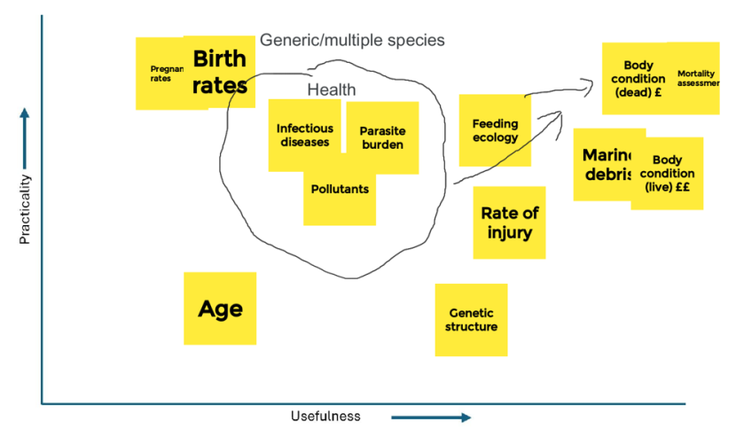
Figure A3.1. Ranking of main metrics under Theme 1 (Animal Health) during the workshop
Click for a full description
A graph displaying post it notes with summary titles and ranking of potential metrics, under Theme 1 (Animal Health) during the workshop, arranged according to the members’ assessment of each metric’s Usefulness and Practicality.
X axis = Practicality
Y axis = Usefulness
Post it notes show the following:
- Birth rates: ranked high for practicality but low for usefulness
- Pregnancy rates: ranked high for practicality but low for usefulness
- Age: ranked fairly low for both practicality and usefulness
- Genetic structure: ranked low for practicality but fairly high for usefulness
- Feeding ecology: ranked fairly high for both usefulness and practicality
- Mortality Assessment: ranked high for both usefulness and practicality
- Body condition (dead): ranked high for both usefulness and practicality
- Body condition (live): ranked fairly high for practicality (relatively expensive) and high for usefulness
- Marine debris: ranked fairly high for practicality and high for usefulness
- Rate of injury: ranked fairly high for both usefulness and practicality
- Infection diseases, pollutants, parasite burden (grouped together as ‘health’): ranked fairly high for practicality but lower for usefulness.
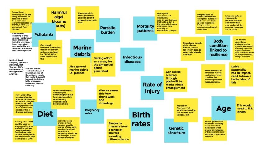
Figure A3.2. Overview of concepts considered during the workshop under Theme 1 (Animal Health)
Click for a full description
A collection of post-it notes with concepts of metrics considered by the Theme 1 (Animal Health) subgroup.
Birth rates
- Simple to measure from a range of sources including citizen science.
- Body condition linked to resilience
- Lipids seasonality has an impact, need to have a better idea on this; measurements of carcasses to assess health from body condition; strandings, length girth photos and measurements – 30 year dataset, citizen science collected; integrate data to understand seasonal changes as a proxy for resilience; live animals laser/drone photogrammetry provides assessment of growth rate, life stages of animals and body condition (proxy for prey availability) changes over time.
Rate of injury
- Can assess scarring through photo ID i.e. minke whale entanglement.
Mortality patterns
- Overlay with abundance and distribution, year on year increase in strandings but is this more effort, more awareness, more mortality, or environmental changes.
Parasite burden
- Can assess through internal (strandings) and external (photo ID) data.
Infectious diseases
Marine debris
- Fishing effort as a proxy for amount of debris generated.
Pollutants
- Harmful algal blooms (HABS); contaminant screening of prey species – need to know more about prey availability, what the animals are feeding on, and diet composition; contaminant screening of POPs and heavy metals can be assessed in detail from necropsies and in some detail from biopsies.
Diet
- Prey – where the animals have been feeding, what they are feeding on, and has this changed recently. Fatty acids and isotope profile in stranded and biopsied animals; feeding rates – PAM could be used to understand prey availability and animals health. Existing PAM data could be re-analysed; understanding prey availability is something we’d like to do and could do from existing stranded and biopsy samples.
Theme 2: Ecology
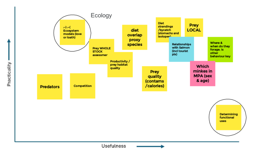
Figure A3.3. Ranking of main metrics under Theme 2 (Ecology) during the workshop
Click for a full description
Circles represent concepts that fall outside the concept of ‘metrics’ but should be carefully considered. Yellow = general (applicable to all species); Blue = specifically relevant to bottlenose dolphin; Pink = specifically relevant to minke whale; Green = specifically relevant to Risso’s dolphin.
X axis = Practicality
Y axis = Usefulness
Post it notes show the following:
- Ecosystem models: ranked high for practicality but low for usefulness
- Predators: ranked low for both usefulness and practicality
- Competition: ranked low for both practicality and usefulness
- Prey whole stock assessment: ranked fairly high for practicality but low for usefulness
- Productivity / prey habitat quality: ranked fairly high for both usefulness and practicality
- Prey quality (contaminants / calories): ranked high for usefulness and lower for practicality
- Diet overlap proxy species: ranked high for practicality but lower for usefulness
- Determining functional uses: ranked very high for usefulness but very low for practicality
- Which minkes in MPA (age/sex): ranked high usefulness but fairly low for practicality
- Where and when do they forage: ranked very high for both usefulness and high for practicality
- Prey (local): ranked very high for practicality and high for usefulness
- Diet strandings / bycatch (stomach contents / stable isotope): ranked very high for practicality and high for usefulness
- Relationships with salmon (inc. tourist pics): ranked fairly high for both practicality and usefulness
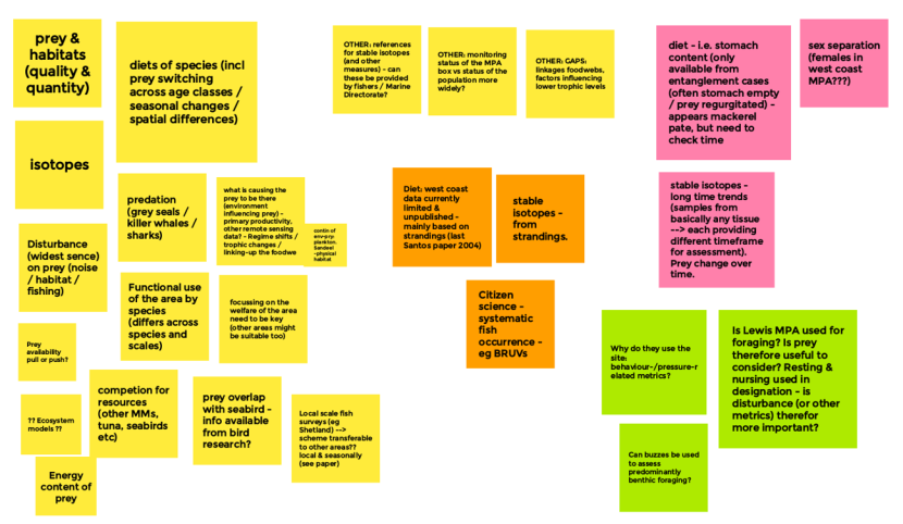
Figure A3.4. Overview of concepts considered during the workshop under Theme 2 (Ecology)
Click for a full description
Yellow = general (applicable to all species); Blue = specifically relevant to bottlenose dolphin; Pink / orange = specifically relevant to minke whale; Green = specifically relevant to Risso’s dolphin.
A collection of post-it notes with concepts of metrics considered by the Theme 2 (Ecology) subgroup.
The post its on the left of the figure are all yellow. Yellow means that the concept is general and applicable to all species.
- Prey and habitats; isotopes; disturbance; energy content of prey; competition for resources; prey overlap with seabirds; diets of species (inc. prey switching, seasonal changes, spatial differences); predation (grey seals, killer whales); functional use of the area.
- Diet (west coast currently limited and unpublished – mainly based on strandings); stable isotopes from strandings; citizen science – systematic fish occurrence e.g. BRUVs.
- The post its in the top right corner are pink and middle post its are orange. Pink and orange mean that the concepts are specifically relevant to minke whale.
- Diet (i.e. stomach contents analysis – only available from entanglement cases); stable isotopes (long term trends in prey changes over time); sex separation (e.g. females in west coast MPA?).
- The post its in the bottom right corner are green. Green means that the concepts are specifically relevant to Risso’s dolphin.
- Can buzzes be used to determine predominantly benthic foraging?; Is the Lewis MPA used for foraging? Resting and nursing used in designation, is disturbance therefore important?; Understanding why they use the site, behaviour metrics important.

Figure A3.4 continued. Overview of concepts considered during the workshop under Theme 2 (Ecology)
Click for a full description
Yellow = general (applicable to all species); Blue = specifically relevant to bottlenose dolphin; Pink = specifically relevant to minke whale; Green = specifically relevant to Risso’s dolphin.
A collection of post-it notes with concepts of metrics considered by the Theme 2 (Ecology) subgroup.
The post its are blue. Blue means that the concepts are specifically relevant to bottlenose dolphin.
- Stable isotopes – big offshore group stranding but empty stomachs; seasonal salmon; diets limited data available but a few additional samples identified from strandings; salmon decline influence on dolphin site fidelity; PAM monitoring of porpoise is an indirect way of monitoring dolphins re: spatial temporal segregation; observational foraging data including from citizen science pics.
Theme 3: Physical environment
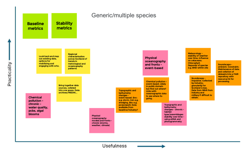
Figure A3.5. Ranking of main metrics under Theme 3 (Physical Environment) during the workshop
Click for a full description
X axis = Practicality
Y axis = Usefulness
Post it notes show the following:
- Baseline metrics: ranked high for practicality but low for usefulness
- Stability metrics: ranked high for practicality but low for usefulness
- Chemical pollution – chronic – ranked low for practicality and low for usefulness
- Look back and map existing data, options for mobilising, and engaging with who: ranked fairly high for practicality but low for usefulness
- Physical oceanography models and fronts: ranked low for practicality but fairly high for usefulness
- Physical oceanography and fronts – event-based: ranked fairly high for practicality and for usefulness
- Meteorology – stability of weather over time e.g. chlorophyll: ranked fairly high for practicality and high for usefulness
- Soundscape – ambient: ranked fairly high for practicality and high for usefulness
- Soundscape – impulsive: ranked fairly low for practicality but high for usefulness
- Topographic and bathymetry changes – chronic – habitat ype/assemblages: ranked low for practicality but fairly high for usefulness
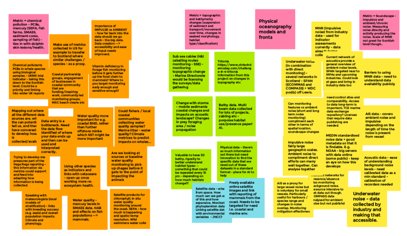
Figure A3.6. Overview of concepts considered during the workshop under Theme 3 (Physical Environment)
Click for a full description
A collection of post-it notes with concepts of metrics considered by the Theme 3 (Physical Environment).
The post its at the top are all pink. These represent selected key metrics from this workshop theme. Under each metric are a number of post its describing ideas of how each metric could be assessed.
Metric: Chemical pollution
- Using whale species biological samples to assess PCB levels. It is a UKMS trial indicator that could be taken down to the Scottish level.
- Vitamin deficiency in forage fish monitoring before it gets further up the food chain to mammals – question around where do you target monitoring so that the metric is sensitive enough.
- Water quality more important for e.g. bottlenose dolphin, rather than offshore minke whale which SST might be more important
- Could fishers / local communities be collecting water quality samples?
- Data entry is a bottleneck; need the data flow identified to where the data should end up
- Trying to develop the pressures part of the Hbs Regs reporting – this information via metrics could support and feed into adapting how information is being collected
Metric: topographic and bathymetry changes
- Tritonia information from this project for monitoring changes in seabed topography
- Change with storms – mobile sediments and coastal changes – impacts on acoustic landscapes, changes in prey foraging area and / or noise propagation
- Freely available online satellite images monitoring phytoplankton, with environmental variables, and link with reporting of mammals from the coast
Metric: Soundscapes – impulsive and ambient / chronic noise
- Scale of MNR (impulsive noise) not great for Scottish level – currently used in indicator assessments
- Underwater noise (in combination with direct monitoring) – several netrowks in Scotland – SPAN (ECOMMAS and COMPASS) + WDC PODs of Lewis
- Current network of acoustics provide a general overview of ambient noise levels. SPAN targeted near to MPAs and upcoming marine industries. Look at gaps and bring in industry data too
- AIS data covers ambient noise and impulsive depending on the length of time the noise is present from vessel
- Acoustics data – ease of understanding background noise levels
- Underwater noise data being collected by industry and making that accessible is important
- AIS is a proxy for large vessel noise but is voluntary for small vessels. Particularly useful for harbours / species range and changes in noise overlap. Monitoring mitigation effectiveness
- Impulsive noise fairly large geographical scales. Ambient noise to compliment direct efforts can marry well together. And can be analysed together
Theme 4: Direct impacts
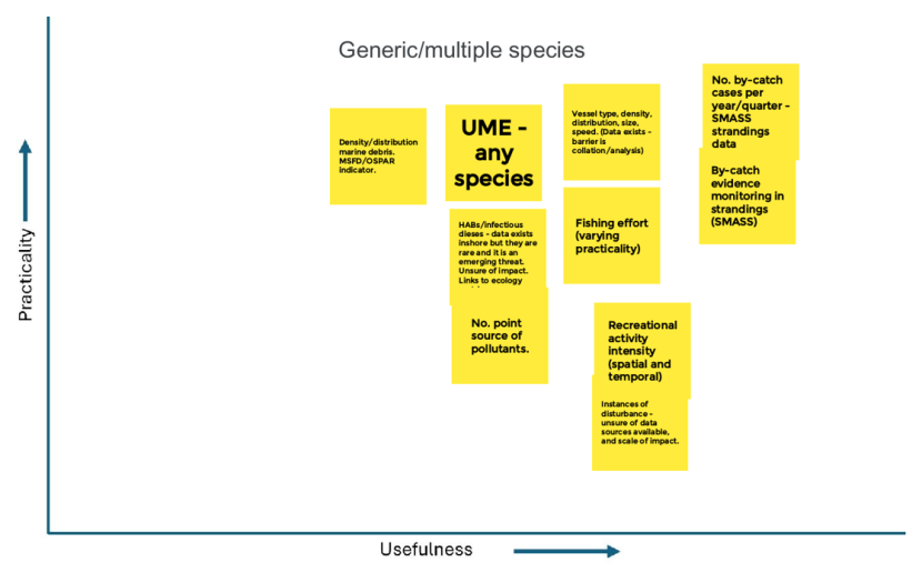
Figure A3.7. Ranking of main metrics under Theme 4 (Direct Impacts) during the workshop
Click for a full description
X axis = Practicality
Y axis = Usefulness
Post it notes show the following:
- Density distribution of marine litter (MSFD/OSPAR indicator): ranked high for practicality but fairly low for usefulness.
- UME (any species): ranked high for practicality but fairly low for usefulness.
- HABs/infectious diseases: ranked fairly low for both practicality and usefulness.
- Vessel type, density, distribution, size: ranked high for practicality but fairly low for usefulness.
- Fishing effort (varying practicality): ranked fairly low for practicality but higher for usefulness.
- Recreational activity intensity: ranked fairly low for practicality but high for usefulness.
- Number of bycatch cases per year/quarter: ranked high for practicality and usefulness.
- Bycatch evidence monitoring in strandings: ranked high for practicality and usefulness.
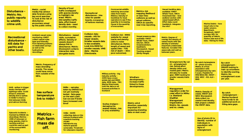
Figure A3.8. Overview of concepts considered during the workshop under Theme 4 (Direct Impacts)
Click for a full description
The post its at the top all represent selected key metrics from this workshop theme. Under each metric are a number of post its describing ideas of how each metric could be assessed.
Disturbance metric: number of public reports to wildlife crime unit
- Repeat visits, cumulative effects; density of vessels doesn’t always link to disturbance – Shorewatch collect interaction data.
- Recreational disturbance – AIS data for yachts and other boats
- Ambient vessel noise monitoring - HWDT collect vessel noise data from listening stations on dedicated surveys
Metric: collision risk
- MMO website for vessel tracks and density
- Likelihood and near miss collisions as well as actual collisions. ORCA do specific near miss reporting
Metric: AIS traffic data and effort based density data – need to collect monthly from both sources
- Density of boat traffic overlapping with species density to highlight risk areas
Metric: frequency of mass stranding events
- HAB – spikes in trigger levels overlap with sightings rates
- Sea surface temperature linked to HABs
- HABs samples taken by SMASS but not routinely tested. Data gaps on east coast.
- HABs – SAMS collecting data on this with particle tracking model
Metric: entanglement/bycatch
- Entanglement risk, fishing effort intensity (static and mobile gear)
- Photo ID of scars, % of live population with entanglement or bycatch scars
- Density of creels – HWDT and shorewatch collect density of creels. SEA project collated HWDT data.
Annex 4: Information on resource implications
| Broad topic | Metric | Comments on resource implications | Small improvements to data processing, delivery of outputs | In-depth review of existing data | Expansion of existing monitoring schemes | Development of new monitoring schemes | Basic research needed first |
|---|---|---|---|---|---|---|---|
| Cause of Death | AH10: Cause of death (CoD), including changes over time and across species. | More in-depth analysis of data that are already being collected. | X | X | - | - | - |
| Entanglement/ Bycatch/ Commercial fishing | DI01: Number of confirmed cetacean mortalities linked to bycatch or entanglement within/adjacent to MPAs per unit time | More in-depth analysis of data that are already being collected. | X | X | - | - | - |
| Entanglement/ Bycatch/ Commercial fishing | DI04: Density/distribution of static fishing gear (number of units/km2). | Requires considerable time investment for proper conversations – need to link in with fisheries management | X | X | X | - | - |
| Entanglement/ Bycatch/ Commercial fishing | DI03: Proportion of live animals showing evidence of injury through entanglement, collision etc. (e.g., gear attached, scarring). | Review of existing photo-ID catalogue data. Greater focus during shore/boat-based visual surveys -> training. Requires photographic evidence. Access to aerial sightings from industry -> costs? | X | X | X | - | - |
| Entanglement/ Bycatch/ Commercial fishing | DI05: Information on static gear usage (e.g., average, maximum soak times) and distribution, e.g., through surveys of fishers (questionnaires) | Engagement with fisheries managers, social scientists (SEA project) | - | X | X | X | - |
| Underwater Noise | PE01: Soundscape – non-impulsive noise (e.g., shipping, aquaculture, fishing, military activity) | Need for specialised equipment and training Current levels of PAM monitoring inside MPAs should be reviewed based on monitoring needs. Accessing industry PAM data may cost fees. | X | X | X | X | - |
| Underwater Noise | PE02: Soundscape – impulsive noise (e.g., seismic surveys, pile driving, military sonar, explosions, acoustic deterrent devices) | Need for specialised equipment and training Current levels of PAM monitoring inside MPAs should be reviewed based on monitoring needs. Not all data (e.g., military) will be readily accessible. | X | X | X | X | - |
| Prey and Diet | EC06: Prey occurrence/abundance/diversity at local scales: BRUVs, systematic diver surveys, echosounder surveys etc. | Community groups require training, financial support. Spatial scope likely limited relative to area for which monitoring is needed. | - | X | X | X | X |
| Prey and Diet | EC03: Diet composition: Stable isotope analysis | Stable isotope work is done whenever possible, but no funding is currently available to do this as standard. Expansion to do this for more cases, look at remains in more detail, do additional analyses etc.? | - | - | X | - | - |
| General Health | AH18: Birth rates | These data are already being collected and would require only additional analysis. | X | - | - | - | - |
| General Health | AH12: Body condition (linked to animal resilience): observations of live animal (laser or drone photogrammetry). | Expansion of laser/drone photogrammetry efforts where possible/appropriate. | X | - | X | X | - |
| Broad topic | Metric | Comments on resource implications | Small improvements to data processing, delivery of outputs | Review of existing data | Expansion of existing monitoring schemes | Development of new monitoring schemes | Basic research needed first |
|---|---|---|---|---|---|---|---|
| Cause of Death | DI16: Frequency and potential causes of cetacean Unusual Mortality Events (UMEs) per year. | These data are already being collected and would require only minor additional analysis. | X | - | - | - | - |
| Entanglement/ bycatch/ commercial fishing | DI06: Information on spatiotemporal distribution of commercial fishing activity (based on vessel movement): average number of vessel movements within a grid cell (0.05×0.05-degree grid, similar to existing >12m vessel effort data submitted to ICES) for each fishing metier/fleet. | Costs related to organising/sharing existing and future data with NatureScot from across multiple other organisations – liaising with fisheries managers within Marine Directorate will be needed. | X | X | X | - | - |
| Entanglement/ bycatch/ commercial fishing | DI02: Assessment of external evidence of bycatch in stranded animals that are not collected for necropsy. | SMASS could increase focus on recognising signs of bycatch and entanglement during volunteer training, with some cost implications. Photographic evidence will be required. | - | X | X | - | - |
| Prey and Diet | EC01: Diet composition: Stomach content analysis. | These data are already being collected and would require only additional analysis (with caveats on sample size, representativeness and species presence). Cost of analysis is linked to analysing more cases, looking at remains in more detail, do additional analyses etc. | X | X | X | - | - |
| Prey and Diet | EC09: Disturbance of fish habitat (notably sandeels and Atlantic herring): scale of prey species habitat loss due to climate change, commercial fishing, dredging, vessel noise, naval training exercises, coastal construction, cable deployment and other activities. | More analysis of fish habitat data will likely be required. More monitoring may be needed? Close liaison with fisheries managers needed. | - | - | X | X | X |
| Prey and Diet | EC07: Prey occurrence/ abundance/diversity at wider scales: commercial fish surveys, echosounder surveys, and fishery observer programme outcomes. | Survey effort is limited or absent in many parts of Scotland, especially along the west coast.
| - | - | X | X | - |
| Prey and Diet | EC02: Diet composition: Fatty acid analysis | Cost of analysis can be high. Expansion would enable studying more cases, looking for more substances etc. | - | - | X | - | - |
| General Health | AH11: Body condition (linked to animal resilience): Strandings data | These data are already being collected and would require only additional analysis. | X | - | - | - | - |
| General Health | AH17: Pregnancy rates | These data are already being collected and would require only additional analysis. | X | - | - | - | - |
| General Health | AH05: Contaminant screening: concentrations of POPs, heavy metals etc. from necropsies | Cost of analysis can be high Questions to consider whether this is an acute problem, and what can we do about it? Expansion would enable studying more cases, looking for more substances etc. | - | - | X | - | - |
| Wider Ecology | EC11: Determining functional use of areas within MPAs | Large time investment needed to distinguish individual behaviour from wider long-term trends | X | X | X | X | X |
| Broad topic | Metric | Comments on resource implications | Small improvements to data processing, delivery of outputs | Review of existing data | Expansion of existing monitoring schemes | Development of new monitoring schemes | Basic research needed first |
|---|---|---|---|---|---|---|---|
| Cause of Death | AH09: Mortality patterns: distribution, number of strandings per unit effort (if quantifiable) per year. | These data are already being collected and would require only minor additional analysis. | X | - | - | - | - |
| Cause of Death | DI17: UME of any non-cetacean species, farmed in aquaculture – potentially linked to HABs, infectious disease outbreaks or pollution events. | These data are already being collected and would require only minor additional analysis. NB a consistent streamlined approach may need to be developed across taxa. | X | - | - | - | - |
| Cause of Death | DI18: UME of wild non-cetacean species (of any kind) | Need for improved surveillance for infectious diseases, and their potential linkages to cetaceans. New monitoring schemes may be needed for pathogens or host species/groups where surveillance does not currently exist | - | - | X | X |
|
| Entanglement/ Bycatch/ Commercial fishing | DI07: Observations of marine debris with entanglement potential, ghost nets etc., ideally effort-weighted for quantification. | Costs likely due to increased monitoring, aggregation of disparate existing datasets. Costs increase when focusing on gear still in the sea vs on beaches. | X | X | X | X | - |
| Entanglement/ Bycatch/ Commercial fishing | AH01: Frequency of observed marine debris at sea surface per unit time/effort. | Costs likely to be associated with 1) surveying offshore, 2) accessing existing commercial survey data (OWF surveys etc.), 3) collating/integrating disparate data sources, if that is not already being done. | X | X | X | X | - |
| Entanglement/ Bycatch/ Commercial fishing | AH02: Frequency of observed marine debris on beaches. | Costs associated with expanding existing survey activities, improving integration and analysis. | X | - | X | - | -- |
| Collision | DI13: Information on vessel sizes, types, lengths, densities, distribution, movement patterns, and speeds (average and maximum) to identify areas of high collision probability. | Costs associated with implementing and consolidating vessel monitoring activities, integrating data analysis at cetacean-relevant scales. | X | X | X | X | - |
| Collision | DI14: Reporting rates of actual collision events (incl. insurance claims), ideally effort-weighted. | Costs associated with developing a monitoring approach for this metric, as not presently assessed in Scotland. | - | - | - | X | X |
| Collision | DI15: Number of near miss collision events, ideally effort-weighted. | Costs of extrapolating existing ORCA data to other vessel types, extra analysis | - | - | X | X | - |
| Disturbance | DI08: Risk of interactions with vessels (based on vessel movement patterns), mapped against species distribution. | Costs of obtaining AIS, satellite data, additional processing and analysis. | X | - | X | - | - |
| Disturbance | DI11: Wildlife tourboat activities: Density/distribution of tourboat activity in relation to animal encounter rates per unit effort. | Costs associated with getting support and data from tourboat operators, extra processing, analysis. | - | X | X | - | - |
| Disturbance | DI12: Wildlife tourboat activities: Changes to animal encounter rates per unit effort because of repeat exposure to tourboats. | Costs associated with getting support and data from tourboat operators, extra processing, analysis. | - | X | X | X | - |
| Disturbance | DI09: Interactions between recreational vessels and cetaceans that result in disturbance, as part of systematic effort-based cetacean surveys. | Costs of expanding existing nearshore WDC monitoring. Accessing other external data sets. Extra analysis. | X | - | X | X | - |
| Prey and Diet | EC05: Quality of prey (in terms of calorific value, contaminant loads etc.) | Unclear if this is being done in Scotland at present. Costs would mainly be associated with setting up sampling regimes and undertaking analysis. | - | - | - | X | - |
| Prey and Diet | AH19: Diet: rates of feeding activity per unit time (collected using PAM, tags etc.) | Costs of reanalysing existing PAM data archives. Deployment of DTAGs is expensive and logistically difficult, with licensing requirements. | - | X | X | X | - |
| Prey and Diet | EC04: Visual observations of foraging activity (anecdotal/citizen science): individual, regional, seasonal variation in prey consumed. | Costs of reanalysing existing visual survey data in a consistent manner. | X | X | X | - | - |
| Prey and Diet | EC08: Spatiotemporal diversity, relative abundance of prey using eDNA methods. | Not yet being consistently done in Scotland; but methods exist and could be developed further | - | - | - | X | X |
| Prey and Diet | AH20: Diet: rates of feeding activity per unit time (collected using visual observations) | Costs of reanalysing existing visual survey data in a consistent manner. | - | X | X | - | - |
| Prey and Diet | AH21: Diet: monitor seabird diet + breeding success as early warning of changes to prey base | Review of available data + process of integration Comparison between seabird and cetacean diet datasets, spatiotemporal heterogeneity. | - | - | - | - | X |
| General Health | AH15: Age structure of population (teeth, body length, long term photo-ID studies, body length assessment via laser or drone photogrammetry). | Cost of analysis can be high. Additional resources would enable this to be done for more cases. | X | X | X | X | - |
| General Health | AH03: Frequency of marine debris (including microplastics) found inside stranded or bycaught animals. | Cost of analysis can be high. Expansion would enable studying more cases, look at tissues in more detail, do additional analyses etc. | X | X | X | X | - |
| General Health | AH08: Infectious disease occurrence rates. from necropsies of stranded or bycaught animals. | Cost of analysis can be high. Expansion would enable studying more cases. | X | - | X | - | - |
| General Health | AH22: Genetic structure of population(s) to inform on management units, inbreeding, population size etc.) | Samples are collected by SMASS, but not routinely analysed due to lack of resources. Cost of analysis can be high. Expansion would enable studying more cases. | - | - | X | - | - |
| General Health | DI20: Level of HAB toxins found in stranded cetaceans, other marine mammals. | SMASS collects samples but these are not yet routinely tested. Cost of analysis. Expansion would enable studying more cases. | - | - | X | - | - |
| General Health | AH13: Body condition: measurements of blubber thickness. | These data are already being collected and would require only minor additional analysis. | X | - | - | - | - |
| General Health | AH06: Severity of parasite burden found inside stranded or bycaught animals. | These data are already being collected but additional costs would be involved if greater focus were put on molecular assays | X | - | X | - | - |
| General Health | AH14: Body condition: Blubber composition (lipids) | Cost of analysis can be high. Expansion would enable studying more cases, look at tissues in more detail, do additional analyses etc. | - | - | X | - | - |
| General Health | AH07: Severity of external parasite burden observed in the wild or found attached to stranded or bycaught animals. | Costs of revisiting existing photo catalogues and analysing these data. | X | X | - | - | - |
| General Health | AH05: Contaminant screening: concentrations of POPs, heavy metals, toxins associated with HABs etc. from biopsies of live animals. | Cost of analysis can be high. Expansion would enable studying more cases, look at tissues in more detail, do additional analyses etc. | - | - | X | - | - |
| General Health | DI19: Levels of toxins produced by harmful phytoplankton species in water samples. | Costs of sampling offshore away from aquaculture. Ensure methods work for cetaceans. | - | - | X | - | X |
| General Health | DI21: Sea surface temperature (SST) increase as a proxy for HAB likelihood of occurrence | Costs of understanding large-scale climate effects on HABS and wider ecology | - | - | - | - | X |
| General Health | PE08: Contaminant levels in sediment/water samples | Costs of sampling (especially offshore), additional analysis | - | - | X | - | - |
| General Health | AH16: Age structure of population (molecular methods; DNA methylation etc.). | This needs investment in baseline research in Scotland Costs associated with sampling (incl. licensing) | - | - | - | X | X |
| General Health | PE07: Chemical pollution (events-based) | SEPA monitors and maintains data in inshore areas. Coverage offshore limited to non-existent. Additional surveys, analysis will cost. | - | - | X | - | - |
| Wider Ecology | PE05: Topographic and/or bathymetry changes to seabed morphology, rugosity, habitat classification (focused on long-term stability) | Baseline benthic habitat data may not exist in all areas. More work needed on ecological relevance | - | - | X | - | X |
| Wider Ecology | PE06: Strength and persistence of ecologically relevant oceanographic features (e.g., fronts) | Monitoring not currently routinely undertake, will be logistically costly. Integration needed with oceanographic, foodweb models. | - | - | - | X | X |
| Wider Ecology | PE04: Topographic and/or bathymetry changes to seabed morphology, rugosity, habitat classification. | Baseline benthic habitat data may not exist in all areas. More work needed on ecological relevance | - | - | X | - | X |
| Wider Ecology | EC10: Primary productivity as indicator of habitat quality for pelagic fish preyed upon by cetaceans. | Unclear to what extent appropriate models exist – needs engagement with fisheries managers, oceanographers, modelers etc. | - | - | - | - | X |
| Broad topic | Metric | Comments on resource implications | Small improvements to data processing, delivery of outputs | Review of existing data | Expansion of existing monitoring schemes | Development of new monitoring schemes | Basic research needed first |
|---|---|---|---|---|---|---|---|
| Disturbance | DI10: Occupation rates of marinas, rental rate of paddle boards etc., to capture wider levels of marine tourism and thereby indirectly inform on disturbance probability. | Costs associated with collation of disparate datasets, development of novel monitoring schemes, basic research | - | - | - | X | X |
| Wider Ecology | PE03: Effects of meteorology: stability of weather over time/in future, driving changes to prey distribution, habitat structure. | Need for basic research, integration of meteorological, oceanographic model data with cetacean ecology | - | X | - | X | X |
| Wider Ecology | EC12: Level of competition with other predator species (marine mammals, seabirds, tuna etc.). | More work needed on basic research, data integration | - | - | X | - | X |
| Wider Ecology | EC13: Level of predation pressure (by sharks, killer whales, grey seals) on cetaceans: number of observations, abundance of predators (seasonal) across MPA. | More work needed on basic research, data integration | - | X | X | X | X |