NatureScot Research Report 1344 - Use of satellite measures of surface motion to improve the assessment of peat landslide susceptibility
Published: 2025
Authors: David J Large (3) Andrew V Bradley (1), Md. Tariqul Islam (1), Emily Mitchell (2), Ian Dryden (2), Chris Fallaize (2), Roxane Andersen (4) and Chris Marshall (4)
(1) Nottingham Geospatial Institute, University of Nottingham, 30 Triumph Road, Lenton, Nottingham, UK, NG7 2TU
(2) School of Mathematical Sciences, University of Nottingham, Nottingham NG7 2RD, UK
(3) Dept. of Chemical and Environmental Engineering, University of Nottingham, Coates Building, Nottingham, UK, NG7 2RD
(4) Environmental Research Institute, University of the Highlands and Islands, Castle Street, Thurso, UK, KW14 7JD
Cite as: Large, D.J., V Bradley, A.V., Islam, M.T., Mitchell, E., Dryden, I., Fallaize, C., Andersen, R. and Marshall, C. 2025. Use of satellite measures of surface motion to improve the assessment of peat landslide susceptibility. NatureScot Research Report 1344.
Contents
- Keywords
- Background
- Main findings
- Acknowledgements
- Abbreviations
- Introduction
- Methods
-
Results
- How to interpret the results
- Auchlyne, Stirlingshire
- Blairadam, Fife
- Coire a’Bhradain, North Ayrshire, Isle of Arran
- Dalmellington Moss, East Ayrshire
- Delnadamph, Aberdeenshire
- Everan Hill, Angus
- Forsinard Subsite 1, Highland
- Greenhead Moss, North Lanarkshire
- Kirkconnell Flow, Dumfries & Galloway
- Lochrosque Phases 7, 8 & 9, Highland
- Moss of Crombie, Aberdeenshire & Moray
- Mossband Wood, North Lanarkshire
- Peeswit Moss, Midlothian
- Salvaich, Highland
- Stratheskie, Highland
- Uradale, Shetland mainland
- Watch Hill, Scottish Borders
- Site X
- Site Y
- Site Z
- Discussion and recommendations
- References
Keywords
peatland; landslide susceptibility; bog burst; peat slide; InSAR; surface motion
Background
The purpose of this research is to use time-series of surface motion that have been generated using interferometric synthetic aperture radar (InSAR), to improve the assessment of peat landslide susceptibility at 20 peatland sites across Scotland. This method is based on the hypothesis that areas displaying a more extreme range of surface motion in response to weather induced changes in water storage are more likely to be prone to failure. The fundamental principle that underpins this is the relationship between stress (determined by the mass and water content of a peat body), strain (the movement of the peat) and failure by either shearing (peat slides) or tensile failure (bog bursts). The method is designed to enable targeting of areas for more intensive investigation by standard geotechnical techniques (Mills and Rushton, 2023). The benefit of the InSAR method is as a screening tool to rapidly identify areas that are most susceptible to failure. The report provides NatureScot with the data to which independent landslide risk assessments can be compared.
The potential to use peatland surface motion to improve the assessment of peat landslide susceptibility was demonstrated using three landslides that occurred in Ireland in 2020 (Islam et al., 2022). The approach used in these case studies presumed that an unusually high range of vertical surface motion on account of wetting and drying of the peat in response to intra seasonal weather events, should be indicative of an increased susceptibility to failure via landslide or bog burst. Using a percentile scale the study demonstrated that for all three landslides the initial point of failure corresponded to areas that had exceeded the 95th percentile in the range of vertical surface motion and that this increased susceptibility was detectable at least two years prior to failure. This result gave confidence that a high range of motion should be indicative of areas with an enhanced landslide susceptibility and demonstrated the capacity of 20 m resolution data to provide high resolution indications of the areas that may have the greatest risk.
As the risk of landslide is a concern in peatland restoration projects, the aim of this work is to provide NatureScot with high resolution susceptibility maps that improve peat landslide risk assessment and, as a result, improve restoration project design.
Main findings
- High ranges of vertical surface motion are often associated with the position of likely peatland instability within a landscape, and these are often associated with natural drainage lines.
- A high range of vertical surface motion need not imply that failure will occur but does indicate that these areas will be more susceptible to landslide.
- The method complements existing techniques by providing a high resolution overview that enables areas of concern to be identified and targeted for detailed geotechnical and field assessment. The method does not remove the need for a proper geotechnical assessment of the area of concern.
- Future research could investigate whether extreme value theorem could be applied to determine if it is possible to warn of impending failure.
We recommend that if this method is proved to be effective that it is used as part of a standard protocol for assessing sites prior to restoration and to subsequently monitor post-restoration changes in landslide susceptibility.
Acknowledgements
We would like to acknowledge Peatland ACTION at NatureScot for funding the work and providing contextual data. The work was also partly supported by Natural Environment Research Council Grant NE/T010118/1.
Abbreviations
Interferometric Synthetic Aperture Radar (InSAR)
Advanced Pixel System using Intermittent SBAS (APSIS)
Small Baseline Subset (SBAS)
Range of Vertical Surface Motion (RVSM)
Introduction
Peat landslides (slides, flows and bog bursts) are a significant natural hazard particularly associated with areas of blanket peat where steeper slopes, complex topography and generally higher rates of landscape erosion are more likely to lead to peat instability (Warburton, Higgitt and Mills, 2003). Although peat landslides can take many forms (Dykes and Warburton, 2007a, 2008) the underlying causes of increasing load, reduction in effective stress or removal of resisting forces are generally understood and common to all types of slope failure. Hydrology is particularly important as peat landslides are often associated with sudden changes in water input caused by intense rainfall (Warburton, Holden and Mills, 2004; Dykes and Warburton, 2007a, 2007b). The response to such events is in turn determined by the internal structure of the peat and the capacity for deep infiltration along macropores and peat pipes (Warburton, Holden and Mills, 2004) and tensional fissures (Bourke and Thorp, 2005).
Evaluating peat landslide susceptibility is made particularly difficult for several reasons including a lack of information on local variations in the thickness (mass) of peat, poorly characterised geotechnical properties, and the unknown and complex internal structure and hydrology of the peat. Current geotechnical approaches to landslide susceptibility assessment are complex, intensive (Mills and Rushton, 2023) and expensive to deploy at large scale.
To improve on the assessment of peat landslide susceptibility, Islam et al. (2022) demonstrated that areas displaying a high range of vertical surface motion were spatially related to three areas of known peat landslides that occurred on blanket bog in Ireland during 2020. In particular, Islam et al. (2022) showed that the areas of initial failure in all three landslides all exceeded the 95th percentile of the range of vertical surface motion and this was detectable up to two years prior to failure. This investigation was based on the hypothesis that areas displaying a large range of surface motion will also be experiencing large variations in water storage and hence large variations in stress that may, in time, lead to failure of the peat structure. Islam et al. (2022) also noted that these areas are likely to be areas where water naturally accumulates or discharges within the landscape and, hence, may be areas where peat started to accumulate earlier and may therefore be thicker and potentially closer to its limit of mechanical stability.
Comment
The value of the method developed by Islam et al. (2022) is as a low cost means of screening large areas to identify where intensive geotechnical assessment should occur. It does not replace the need for a proper geotechnical assessment of areas of concern, it only enables resources to be focussed on these areas. If InSAR data is being used for other peatland condition assessment (e.g. Bradley et al., 2022, Bradley et al., in press) then the same time-series data can easily be used to determine the range of vertical surface motion and hence landslide susceptibility.
To test the hypothesis used in Islam et al. (2022) in Scotland, 20 peatland sites (Figure 1) were identified for which an independent landslide susceptibility assessment had been undertaken for NatureScot. The authors of this report remain blind to the results of these independent assessments which will be used by NatureScot to determine whether it is worth incorporating methods presented in this report into their landslide susceptibility and risk assessment methodology.

Figure 1. Map of Scotland (Runfola et al., 2020) showing the location of sites used in this study. Base map sourced from Eurostat- European Commission; licensed under Creative Commons Attribution 4.0 International (CC BY 4.0)
Click for a full description
Map of Scotland with the location of sites used in this study indicated by black points:
- Auchlyne, Stirlingshire
- Blairadam, Fife
- Coire a’Bhradain, North Ayrshire, Isle of Arran
- Dalmellington Moss, East Ayrshire
- Delnadamph, Aberdeenshire
- Everan Hill, Angus
- Forsinard Subsite 1, Highland
- Greenhead Moss, North Lanarkshire
- Kirkconnell Flow, Dumfries & Galloway
- Lochrosque Phases 7,8 & 9, Highland
- Moss of Crombie SSSI, Aberdeenshire & Moray
- Mossband Wood, North Lanarkshire
- Peeswit Moss, Midlothian
- Salvaich, Highland
- Stratheskie, Highland
- Uradale, Shetland mainland
- Watch Hill, Scottish Borders
- Locations of sites X, Y and Z are not shown.
Base map sourced from Eurostat - European Commission; licensed under Creative Commons Attribution 4.0 International (CC BY 4.0)
Methods
GIS shapefiles for each site were provided by NatureScot and data was then processed using a modified version of the method published in Islam et al. (2022). An outline of this method with modifications is given below.
InSAR data at 20 m pixel resolution was purchased from Terra Motion Ltd for all sites for the period 2018-2021. An exception to this was Moss of Crombie for which we had existing data for the period 2017-2020. This data was generated from Sentinel-1 imagery using Terra Motion’s in-house APSIS method that provides near continuous coverage over our sites, an essential requirement for effective assessment of surface motion. Islam et al. (2022) provides a summary of the method used excluding commercially sensitive information.
A notable difference from the previous method (Islam et al., 2022) is that a spline was used to remove the longer term (climate, subsidence) and seasonal (evapotranspiration) trends rather than multichannel singular spectrum analysis. The reason to remove these trends is that long-term trends, particularly long-term subsidence, can generate a high range of vertical surface motion without the peat being particularly responsive to the shorter-term weather patterns that appear to be associated with peat landslides. The reason for choosing the spline method over the multichannel singular spectrum analysis was its computational efficiency. A comparison between the spline method and the multichannel singular spectrum analysis method was made using the published data on the Irish landslides and no significant difference was detected.
Following the method in Islam et al. (2022) the range of vertical surface motion was then measured as the difference between maximum and minimum values in the time-series during defined annual periods (2018-19, 2019-20, 2020-21) and for the entire period (2018-2021). The data was then combined for every site and classified in the following percentile ranges: > 95th (very high), 90– 95th (high), 85–90th (moderate), 80–85th (low) and < 80th (negligible) (Figure 2).
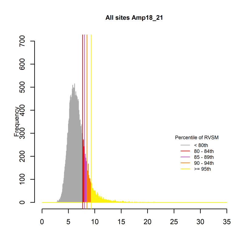
Figure 2. Histogram showing of the classified percentile range of vertical surface motion from all sites during the periods of investigation
Click for a full description
Histogram showing of the classified percentile range of vertical surface motion (RSVM) from all sites during the periods of investigation. The y-axis axis is the pixel count. Range of vertical surface motion is classified using percentile ranges as follows: > 95th (very high), 90– 95th (high), 85–90th (moderate), 80–85th (low) and < 80th (negligible).
Results
For most sites, a single classified map of the percentile range in vertical surface motion for period 2018-2021 is presented alongside a summary of observations and a general interpretation of the patterns on the site. For the Moss of Crombie site this period is 2017-2020. Site names are the names of the shapefiles provided by NatureScot. Where notable annual changes in the classification have occurred during the period of observation this is noted in the summary. For each area the classified data is provided in a .csv file.
How to interpret the results
When considering the implications of the results the following should be considered:
- A high range of vertical surface motion is indicative of processes occurring in that area that could enhance the landslide susceptibility e.g. large changes in effective stress due to blocked peat pipes or blocked drainage at the interface with peat and substrate, discharge of water under the peat etc.
- The observed range of vertical surface motion will depend on the hydrological and weather extremes encountered during the period of measurement e.g. a generally wet year is unlikely to produce the same extremes as a dry spring followed by a wet summer.
- Areas with a high range of vertical surface motion should be considered as targets for further investigation into other factors that will contribute to landslide susceptibility e.g. peat thickness, substrate topography and local hydrology, and risk factors common to all landslides e.g. loading, removal of toe of slope, drainage and material strength.
- Greatest susceptibility is most likely to occur when areas with a high range of vertical surface motion occur on slopes in thick unconfined peat bodies.
- Even small areas with a persistent high range of vertical surface motion can be indicative of a high landslide susceptibility e.g. the Shass Mountain landslide (Islam et al., 2022).
Auchlyne, Stirlingshire
Location: 56.437136°, -4.466431°
Area: 77 ha
Site Description
- On a larger scale the site is located on a break in slope at an altitude of approximately 450 m. Locally the site appears hummocky on an optical image.
- Drainage is to the south and northeast with a watershed between the two drainage basins occurring in the eastern part of the site.
- Extensive drain-blocking was undertaken on the site in early 2018, with hag reprofiling also being completed. Notable peat erosion can be seen in optical imagery along the northern boundary, most notably to the northeast.
- No evidence of previous landslides was observed on optical imagery.
Description of the range of vertical surface motion (Figure 3)
- An extensive area with a high range in vertical surface motion is associated with the upslope extension of natural drainage lines and a local break in slope in the north-eastern part of the site.
- No notable year-on-year changes in the dominant patterns in the range of vertical surface motion are observed.
Landslide Susceptibility interpretation
- Greatest landslide susceptibility is probably where extensive areas with a high range of vertical surface motion occur in the north-eastern part of the site.
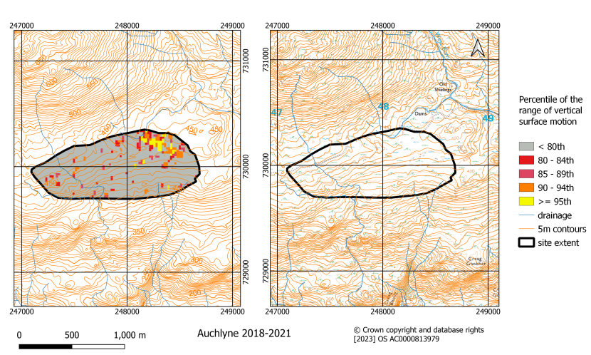
Figure 3. Classified map of the range of vertical surface motion during the period 2018 - 2021 for the Auchlyne site. Both maps include the British National Grid
Blairadam, Fife
Location: 56.134981°, -3.471492°
Area: 526 ha
Site Description
- The site is a predominantly forested area on low hills at an altitude of between 200 and 300 m. Hills are locally steep with small outcrops of rock. The A823 road crosses the southwest corner of the site.
- Three major drainage basins occur on the site all draining towards the southeast.
- Forest clearance has occurred in the southwest edge of the site and in some smaller areas near Loch Glow.
- No evidence of previous landslides was observed on optical imagery.
Description of the range of vertical surface motion (Figure 4)
- Small areas with a high range of vertical surface motion are scattered across the site. Larger extents with a high range of vertical surface motion occur adjacent to Din Moss (Figure 4, area A), in the centre of Craiggaveral Moss (Figure 4, area B) and on the southern edge of the site close to The Dean (Figure 4, area C) and associated with drainage lines in the western part of the site on the edge of Black Rigg and Blackrigg Moss.
- The area with a high range of vertical surface motion adjacent to Din Moss persists in all years. Other areas are more variable.
Landslide Susceptibility interpretation
- Highest potential susceptibility to landslide appears to occur adjacent to Din Moss just west of the A823 road. Other areas may require caution, particularly where associated with steeper slopes or drainage lines.
- The variability of range of vertical surface motion over much of the site is consistent with the relative noisiness of data over forestry and may not indicate any specific areas of higher landslide susceptibility.
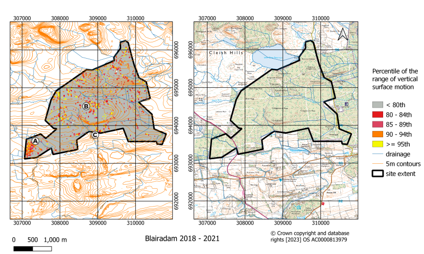
Figure 4. Classified map of the range of vertical surface motion during the period 2018 - 2021 for the Blairadam. Both maps include the British National Grid. Areas in the vicinity of A, B and C are referred to in the report
Coire a’Bhradain, North Ayrshire, Isle of Arran
Location: 55.598244°, -5.228739°
Area: 43 ha
Site Description
- This site on the Isle of Arran lies on the southwest slopes of Beinn Nuis at an altitude of approx. 325 m. The main footpath to Beinn Nuis and other nearby hills crosses the site.
- Natural drainage runs along the northeast and southern margins of the site and artificial drainage is extensive with most drains ultimately discharging on the eastern margin.
- On optical images deep gullies appear to be present over much of the site except in the areas that have been artificially drained.
- Over 8 km of drains were blocked in late 2019.
- No evidence of previous landslides was observed on optical imagery.
Description of the range of vertical surface motion (Figure 5)
- A high range of vertical surface motion is systematically associated with the artificial drainage pattern on the site.
- An area with a moderately high range of vertical surface motion is in the north of the site (Figure 5, area A) and is apparent in the 2018 and 2021 data.
- In 2019 the site experienced little systematic vertical surface motion.
Landslide Susceptibility interpretation
- The association of a high range of vertical surface motion with the main artificial drainage lines may be linked to the rewetting caused by drain-blocking in 2019, and further local field assessment is required to confirm any slide risk.
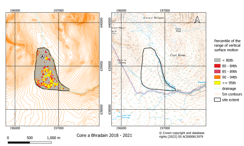
Figure 5. Classified map of the range of vertical surface motion during the period 2018 - 2021 for the Coire Bhradain site. Both maps include the British National Grid. The area in the vicinity of A is referred to in the report
Dalmellington Moss, East Ayrshire
Location: 55.328147°, -4.421378°
Area: 33 ha
Site Description
- The site is a lowland raised bog lying on a floodplain of the River Doon at an altitude of 160 m, between the A713 and B741 roads, 1.5 km west of the town of Dalmellington.
- Natural drainage of the site is to the south towards the River Doon and a minor east-west tributary that crosses the site. The north, east and west margins of the site are bounded by drains and one major drain crosses the eastern part of the site which appears to have been blocked. Faint traces of a denser drainage network were noted on optical images and occur across the site.
- The site is part of what at one time was a much larger peat body that clearly extended to the north of the A713 road. No other notable features were observed on the site.
- There have been several phases of habitat enhancement on the site since the 1990’s, including installation of tin dams and plastic piling, and in 2015, drains were blocked with peat dams and a deep trench bund was installed along the north of the site.
- No evidence of previous landslides was observed on optical imagery.
Description of the range of vertical surface motion (Figure 6)
- A large area with a high range of vertical surface motion runs from southeast to northwest across the site terminating adjacent to the A713 road. Another area with high range of vertical surface motion occurs in the vicinity of the blocked eastern drainage line where it abuts the A713 road.
- Little surface motion occurs in 2019.
- Areas with a high range of vertical surface motion tend to move towards the northern boundary of the site from 2018 to 2021.
Landslide Susceptibility interpretation
- The juxtaposition of a high range of vertical surface motion adjacent to the A713 road, to the north, and particularly in the area that has been drain blocked raises the question of whether the A713 has perturbed the underlying drainage. This could happen via compaction that has resulted in water ponding adjacent to the road.
- Whether this represents an increased landslide susceptibility is uncertain, but it may be worth investigating whether it is influencing the structural integrity of the road.
- Changing patterns of surface motion from 2018 to 2021 could represent the rewetting response to restoration work.
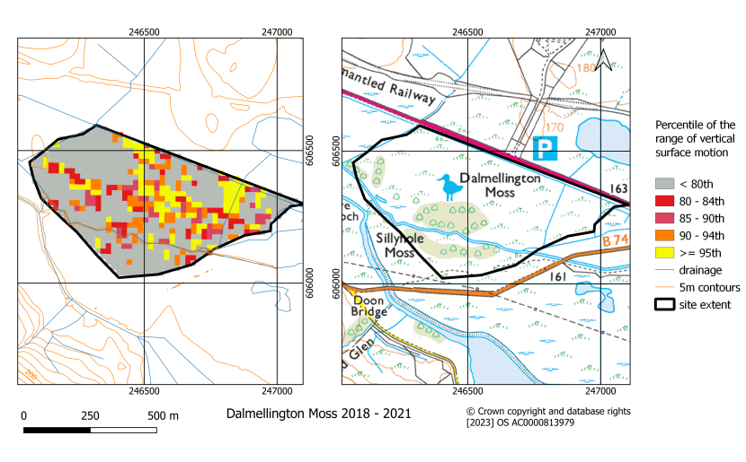
Figure 6. Classified map of the range of vertical surface motion during the period 2018 - 2021 for the Dalmellington Moss site. Both maps include the British National Grid
Delnadamph, Aberdeenshire
Location: 57.181656°, -3.326211°
Area: 193 ha
Site Description
- The site is an area of grouse moor at in the north-eastern Cairngorms at an altitude of between 500 and 700 m. Most of the site is on the relatively steep eastern slopes of Craig Veann.
- Most of the area drains to the east. The south of the site is characterised by a number of large drains which contour the hill.
- Eroded peat with gullies and hags occurs on the upper slopes of Craig Veann and adjacent hills.
- The lower slopes have been managed as grouse moors with characteristic burn pattern and extensive drains.
- No clear evidence of previous landslides was observed on optical imagery.
Description of the range of vertical surface motion (Figure 7)
- There are several areas with a high range of vertical surface motion across the site. A notable band of high range of vertical surface motion extends from the summit of Craig Veann eastwards following the natural drainage line from the eroded, gullied peat to the main watercourse draining the corrie (Figure 7, area A).
- A notable area with a high range of vertical surface motion east of the main natural drainage line corresponds to the area of drains (Figure 7, area B). Another area of with a high range of vertical surface motion in the south of the site also corresponds to an area of peat drainage (Figure 7, area C).
- Little surface motion occurred in 2019.
- Most of the site displays similar patterns in the range of vertical surface motion throughout the period except in the northern area of drain blocking that only shows a high range of vertical surface motion in 2018.
Landslide Susceptibility interpretation
- This is a large and complex site in which the greatest landslide susceptibility is persistently associated with natural drainage lines and areas of artificial drainage. This may indicate that the artificial drainage has not been particularly effective, and these areas should be carefully assessed if they are to be restored.
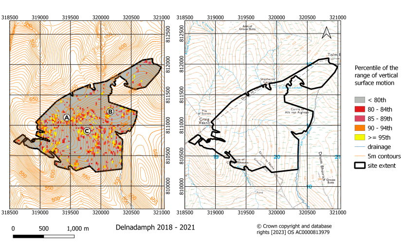
Figure 7. Classified map of the range of vertical surface motion during the period 2018 - 2021 for the Delnadamph site. Both maps include the British National Grid. Areas in the vicinity of A, B and C are referred to in the report
Everan Hill, Angus
Location: 56.916967°, -3.047336°
Area: 92 ha
Site Description
- The site spans Glen Lee in the Eastern Cairngorms at an altitude of 500-600 m with the highest ground to the south and southwest.
- Main natural drainage is into Glen Lee. Hag reprofiling and drain-blocking was done in late 2018 in the west of the site, with gully reprofiling and blocking being completed in the west in 2020.
- Peat to the south and east of the site is deeply gullied and eroded. Some ditch blocking appears to have taken place, possibly alongside other interventions e.g. hag reprofiling.
- No obvious areas of peat failure were observed in optical images.
Description of the range of vertical surface motion (Figure 8)
- Patches with a high range of vertical surface motion are associated with areas of peat erosion and blocked ditches throughout the area.
- An area of high range of vertical surface motion in the west (Figure 8, area A) is predominantly expressed in 2018. An area with a moderately high range of vertical surface motion is observed on the north-west side of Everan Hill in 2021. No distinct spatial patterns were noted in 2019 and 2020.
- An area with a high range of vertical surface motion on the south side of the col leading to Everan Hill (Figure 8, area B) does not appear to coincide with areas of restoration activity.
Landslide Susceptibility interpretation
- Given the relatively steep nature of the site, areas of high range of vertical surface motion should be considered as being potentially susceptible to peat failure and the risk evaluated relative to the known site history and field evidence.
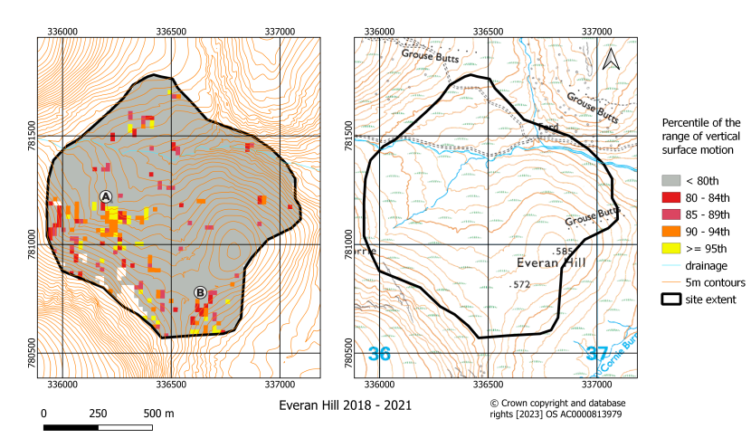
Figure 8. Classified map of the range of vertical surface motion during the period 2018 - 2021 for the Everan Hill site. Both maps include the British National Grid. Areas in the vicinity of A and B are referred to in the report
Forsinard Subsite 1, Highland
Location: 58.409147°, -3.942550°
Area: 48 ha
Site Description
- The site lies in an area of forest to the north of Cross Lochs and west of Forsinard in the Flow Country. The site slopes moderately to the northwest.
- On optical imagery the site is forested.
Description of the range of vertical surface motion (Figure 9)
- A very high range of vertical surface motion occurs across the site. The pattern is somewhat mottled, and this may indicate an inherent noisiness in the InSAR signal due to the trees.
Landslide Susceptibility interpretation
- Although this interpretation should be treated with caution on account of the variable nature of the signal over this site, the whole site should be considered as potentially susceptible to landslide.
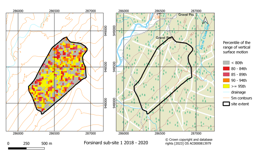
Figure 9. Classified map of the range of vertical surface motion during the period 2018 - 2021 for the Forsinard Subsite 1. Both maps include the British National Grid
Greenhead Moss, North Lanarkshire
Location: 55.774731°, -3.894914°
Area: 17 ha
Site Description
- Greenhead Moss is a small remnant raised bog just south of Cambusnethan in North Lanarkshire.
- The area has been intensively drained. The natural direction of drainage is not obvious, but it is probably to the northeast and south.
- Drain-blocking and peat bank reprofiling was completed in 2015.
- There was a bog burst in the south of the site in 2015.
Description of the range of vertical surface motion (Figure 10)
- In this area there are very few areas where the range of vertical surface motion exceeds the 80th percentile. Those that do are on the site boundary at its northern and eastern corners.
- No evidence of peat failure was observed.
Landslide Susceptibility interpretation
- The area has a very low landslide susceptibility.
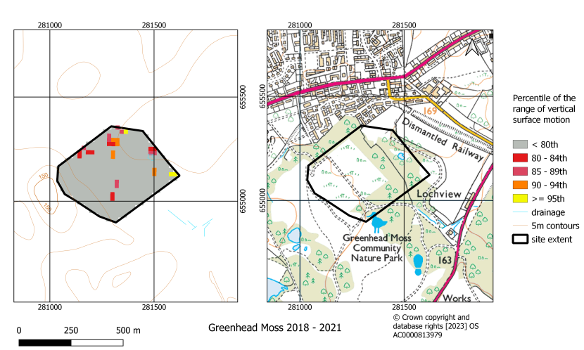
Figure 10. Classified map of the range of vertical surface motion during the period 2018 - 2021 for the Greenhead Moss site. Both maps include the British National Grid
Kirkconnell Flow, Dumfries & Galloway
Location: 55.013014°, -3.609503°
Area: 87 ha
Site Description
- The site is a lowland raised bog lying close to sea-level in the valley of the River Nith just north of the Nith Estuary.
- The site has been extensively drained. Natural drainage was probably towards the River Nith.
- The peatland has undergone extensive restoration with clear evidence of ditch blocking and bunding that contours the northern end of the site.
- No evidence of previous landslides was observed on optical imagery.
Description of the range of vertical surface motion (Figure 11)
- An elongate area with a high range of vertical surface motion runs southeast to northwest along the line of a footpath and corresponding transition in landcover on the western side of the bog (Figure 11, area A).
- An area with a high range of vertical surface motion occurs close to the northern end of this footpath in an area where restoration activities appear to have contoured the surface (Figure 11, area B).
- Another area showing a high range of surface motion occurs in the south-eastern central part of the peat (Figure 11, area C).
Landslide Susceptibility interpretation
- Given the low-lying nature of the site and lack of notable slopes the areas with a high range of vertical surface motion most probably correspond to areas where water is ponding and may be controlled by the drainage pattern.
- Given the low lying and confined nature of the site high landslide susceptibility seems unlikely, but factors such as peat depth and the slope of underlying substrate would need to be considered in any local geotechnical assessment of the site.
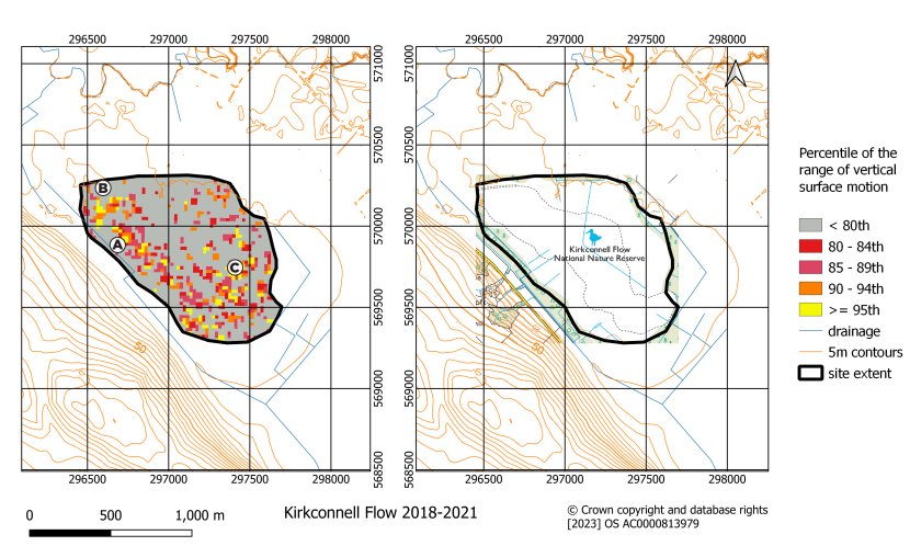
Figure 11. Classified map of the range of vertical surface motion during the period 2018 - 2021 for the Kirkconnell Flow site. Both maps include the British National Grid. Areas in the vicinity of A, B and C are referred to in the report
Lochrosque Phases 7, 8 & 9, Highland
Location: 57.602469°, -5.022817°
Area: 1046 ha
Site Description
- The site contains two subsites each containing eroded blanket bog to the south of Loch Fannich.
- A complex network of eroded gullies that in the northern subsite drain north to Loch Fannich and in the southern subsite drain east-north-east.
- Drainage and ditch blocking is apparent at the eastern edge of the southern site, with restoration work being undertaken in early 2021.
- On optical images some possible evidence of peat landslides was noticed at the eastern edge of the southern site where the slope steepens.
Description of the range of vertical surface motion (Figure 12)
- Many localised areas with a high range of vertical surface motion occur across the site.
- More extensive areas with a high range of vertical surface motion occur towards the eastern edge of the southern site (Figure 12, area A) and associated with the main drainage across this site.
Landslide Susceptibility interpretation
- Greatest susceptibility is associated with the southern site close to areas where historical failure may have occurred.
- The rather irregular and noisy pattern is consistent with the eroded and discontinuous nature of the peat.
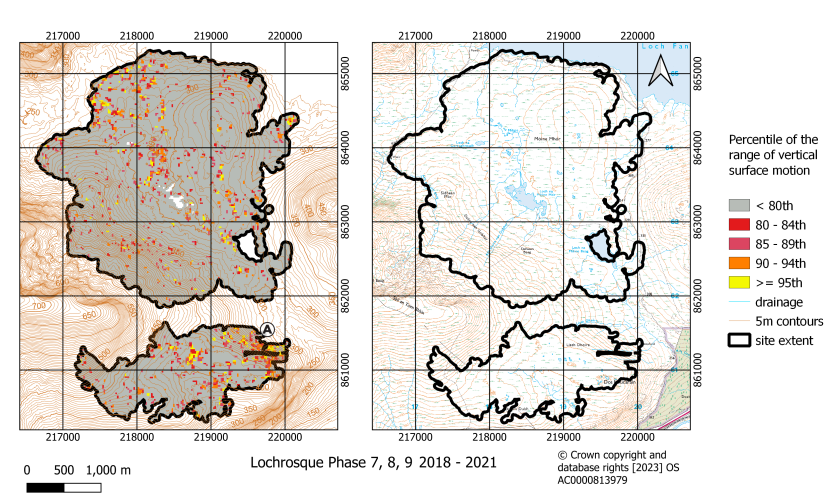
Figure 12. Classified map of the range of vertical surface motion during the period 2018 - 2021 for the Lochrosque Phases 7,8 & 9 site. Both maps include the British National Grid. The area in the vicinity of A is referred to in the report.
Moss of Crombie, Aberdeenshire & Moray
Location: 57.558977°, -2.714767°
Area: 148 ha
Site Description
- The site is a small area of degraded and partially restored intermediate bog on an isolated upland to the west of Aberchirder.
- The site is a gently undulating hilltop at an altitude of between 195 and 225 m.
- Drainage, both natural and artificial is to the north, east and west.
- Historically the site experienced drainage and intensive peat cutting around the margins, leaving a core area of degraded peat in the centre.
- Metal dams were used to block larger drains in 2009. Further restoration in early 2018 saw extensive blocking of small drains, peat bank reprofiling, limited surface bunding and the insertion of plastic dams in a larger drain.
- No evidence of previous landslides was observed on optical imagery.
Description of the range of vertical surface motion (Figure 13)
- Areas with a high range of vertical surface motion are predominantly found around the margins of the site.
- Areas with a more persistently high range of vertical surface motion occur at the upper part of drainage lines on slopes with a northern aspect. However, in general there is little contiguous pattern of vertical surface motion behaviour.
- No particularly systematic changes year on year were noted.
Landslide likelihood interpretation
- The absence of large areas of contiguous behaviour and the highly localised areas with a high range of vertical surface motion although somewhat systematic indicate a relatively low likelihood of major failure.
- Greatest landslide susceptibility is associated with possible localised failures on the upslope extensions of drainage lines and other small areas with a high range of vertical surface motion.
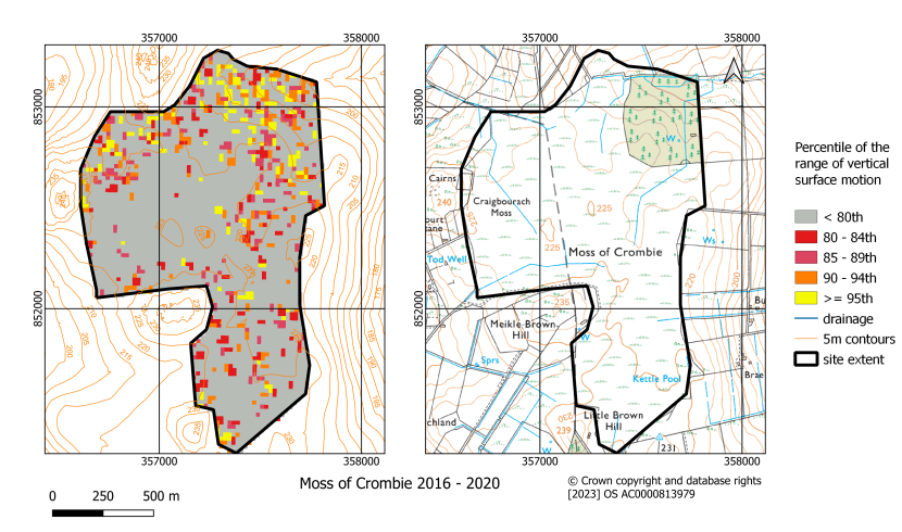
Figure 13. Classified map of the range of vertical surface motion during the period 2017 - 2020 for the Moss of Crombie site. Both maps include the British National Grid
Mossband Wood, North Lanarkshire
Location: 55.8215010°, -3.8218236°
Area: 22 ha
Site Description
- The site lies at an altitude of 225 m just west of the town of Shotts. On a large scale the site sits on a spur that forms a watershed between two natural drainage lines, one draining to the southwest and the other to the southeast. Artificial drainage of the site is now to the east and southeast.
- The peatland appears to consist of two amalgamated bodies that span the watershed. The site has been drained, and ponding of water is observed on the north-eastern margin, presumably partly restored. A possible small pond occurs in north central part of the peatland possibly associated with seepage.
- A landslide, with subsequent remediation, is known to have occurred in the winter of 2018/19 (point A, Figure 14, I McKee [Peatland ACTION], pers. comm.).
Description of the range of vertical surface motion (Figure 14)
- A large area of high range of vertical surface motion occurs in the south-central and western part of the site that extends to the southwestern margin.
- It is notable that in the western areas a high range of vertical surface motion occurs where the natural drainage would probably have been to the southwest.
- The range of vertical surface motion in 2018 and 2020 was negligible across the site. Other years display a relatively consistent pattern with the greatest susceptibility being more extensive in 2019, and less extensive and more localised to the north and west of the known landslide in the 2020 data.
Landslide Susceptibility interpretation
- Greatest landslide susceptibility is probably associated with the southwest margin where the underlying topography probably steepens towards the natural southwestern drainage line. However other areas of high susceptibility occur along the central southern part of the site.
- Given the apparent complexity of drainage and the high range of vertical surface motion on the site careful water management would need to be considered to avoid increasing the risk of landslides.
- Landslide remediation work appears to have reduced the post 2019 landslide susceptibility at point A (Figure 14).
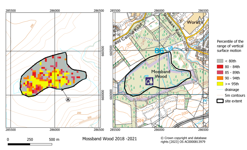
Figure 14. Classified map of the range of vertical surface motion during the period 2018 - 2021 for the Mossband Wood site. Both maps include the British National Grid. Point A is the location of a known landslide (I McKee, pers. comm.).
Peeswit Moss, Midlothian
Location: 55.782692°, -3.137742°
Area: 44 ha
Site Description
- This small raised bog lies on a natural watershed between three main drainage lines at an altitude of 280m. To the south of the site the land rises gently to Toxside Hill.
- Drainage is to the east, west and north-east.
- On optical images the site appears to have been extensively drained, with the vegetation in the southern part of the site appearing to have been burned or cut in rectangular patches, likely indicative of management for grouse, Lagopus lagopus scoticus.
- Extensive drain-blocking was completed in early 2019 in the central/eastern area of the bog and also in the south.
- No evidence of previous landslides was observed on optical imagery.
Description of the range of vertical surface motion (Figure 15)
- An extensive area with a high range of vertical surface motion occurs on the southern edge of the site with another notable area associated with the north-eastern drainage line.
- This pattern of range of vertical surface motion is almost entirely due to surface movement in 2018. In 2019, an area with a high range of vertical surface motion is more centrally located on the site and in 2020 and 2021 no significant areas with a high range of vertical surface motion are observed.
Landslide Susceptibility interpretation
- The diminishing range of vertical surface motion over time may indicate that the high range of vertical surface motion was associated with restoration work on the site and that overall, the site now has a very low landslide susceptibility.
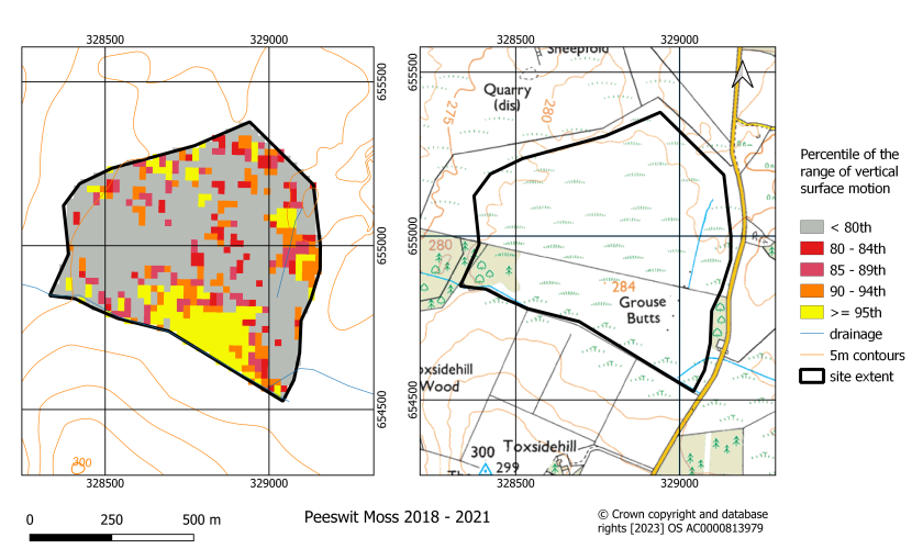
Figure 15. Classified map of the range of vertical surface motion during the period 2018 - 2021 for the Peeswit Moss site. Both maps include the British National Grid
Salvaich, Highland
Location: 58.217925°, -3.670419°
Area: 563 ha
Site Description
- This large area of blanket bog contains several subsites at an altitude of 200 – 300 m on the southern flanks of the hills, Morven, Smean and Sal-vaich.
- Natural drainage is southwards into the Langwell Water and the area has been covered in an extensive network of artificial drains.
- Extensive drain-blocking and hag reprofiling work was undertaken in 2021.
- Over such a large area it is hard to determine if there is unequivocal evidence of peat slides from optical images. Some of the area north of Wag may show evidence of small peat landslides.
Description of the range of vertical surface motion (Figure 16)
- There are several extensive areas with a high range of vertical surface motion within the sites, most associated with the natural drainage and or the confluence of the natural drainage systems (e.g. the large area northwest of Wag, Figure 16, area A).
- Although extents of areas with high range of vertical surface motion vary somewhat year on year the areas displaying the highest range of vertical surface motion remain relatively constant.
Landslide Susceptibility interpretation
- The sites contain large areas with a high range of vertical surface motion that are likely to be more susceptible to landslide.
- Detailed analysis of this situation would be required relative to restoration work to understand the actual susceptibility in the high surface motion range areas identified.
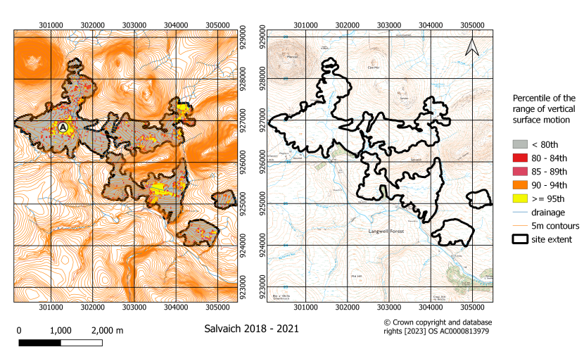
Figure 16. Classified map of the range of vertical surface motion during the period 2018 - 2021 for the Salvaich site. Both maps include the British National Grid. The area in the vicinity of A is referred to in the report
Stratheskie, Highland
Location: 58.061419°, -4.888072°
Area: 15 ha
Site Description
- This small site is in Srath Seasgaich. It is an area of former forestry on a slope with a north-eastern aspect at an altitude of 240 m.
- The site drains north-eastwards, into the Allt Srath Seasgaich on its north-eastern margin.
- On optical images the area appears to have undergone forest to bog restoration.
Description of the range of vertical surface motion (Figure 17)
- Almost the entire site has a high range of vertical surface motion.
- The high range of vertical surface motion is almost entirely due to movement in 2021. Prior to this the range of vertical surface motion was variable and often low with no distinct patterns or trends.
Landslide Susceptibility interpretation
- The sudden changes in the range of vertical surface motion in 2021 should be investigated and the site monitored to determine whether these changes are sustained. It is possible that the changes were due to a neighbouring uphill site being re-wetted in 2020/21, with the increased wetness and instability being a response to this neighbouring site feeding water into it in a more consistent manner, (I McKee [Peatland ACTION], pers. comm.).
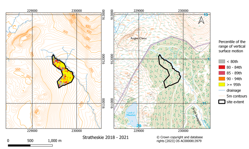
Figure 17. Classified map of the range of vertical surface motion during the period 2018 - 2021 for the Stratheskie site. Both maps include the British National Grid
Uradale, Shetland mainland
Location: 60.124322°, -1.253694°
Area: 445 ha
Site Description
- The site on the Shetland Islands is a hilly area of peatland with topographic relief of about 180 m, from sea level.
- Drainage is predominantly along the north-north-east to south-south-west geological structural trend in the area.
- There is abundant evidence of previous and recent peat failures in the area, for example the slopes to the east of Uradale Farm (Figure 18, area A).
Description of the range of vertical surface motion (Figure 18)
- High and very high range of vertical surface motion values occur across the site primarily at the heads of valleys on valley sides and the natural upward extension of drainage lines.
- A particularly persistent area of high range of vertical surface motion occurs at the head of a valley in the south of the site (Figure 18, area B)
Landslide Susceptibility interpretation
- Given the history of peat landslides on the site, areas with an extremely high range of vertical surface motion at the heads of valleys and on valley sides should be considered susceptible to landslide.
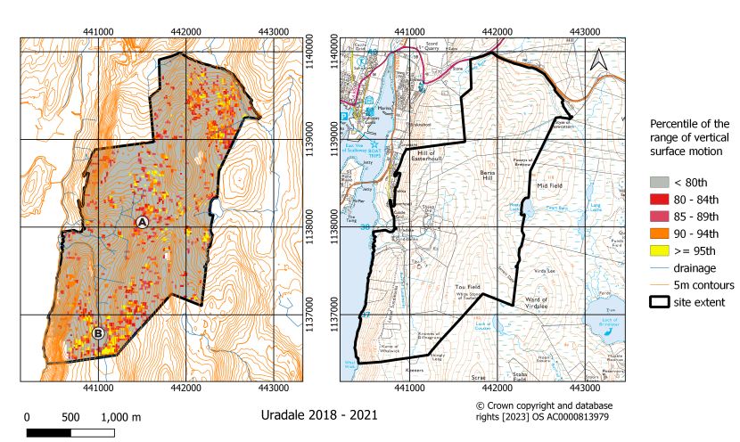
Figure 18. Classified map of the range of vertical surface motion during the period 2018 - 2021 for the Uradale site. Both maps include the British National Grid. Areas in the vicinity of A and B are referred to in the report
Watch Hill, Scottish Borders
Location: 55.209344°, -2.872444°
Area: 247 ha
Site Description
- The site lies at an altitude of 450 – 500 m to the south of Millstone Edge, on gentle to moderate slopes with an overall south-easterly aspect.
- Natural drainage is to the south-east via Rough Gill, Long Gill, and Hog Gill. The area has an extensive network of artificial drains.
- The peatland is dissected by a network of broad gullies, predominantly on the slightly steeper slopes and in the upper stream extension of the natural drainage lines.
- No evidence of previous landslides was noted on optical imagery.
Description of the range of vertical surface motion (Figure 19)
- Areas with a high range of vertical surface motion are associated with the upper extension of drainage lines, particularly the upper part of Long Gill.
- Little surface movement was observed in 2018 and 2021 with most of the movement occurring in 2019 and 2020.
- Over much of the site areas with a high range of vertical surface motion are variable from year to year. The most persistent area with a high range of vertical surface motion is between Long Gill and Hog Gill at eastern edge of the site (Figure 19, area A).
Landslide Susceptibility interpretation
- Areas with a high range of vertical surface motion that could be logically associated with greater landslide susceptibility are those in the upper parts of Long Gill. The year-on-year variability in these areas could however be due to activities on the site e.g. restoration work.
- The greatest landslide susceptibility is most likely associated with area A (Figure 19).
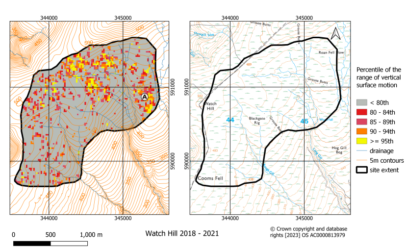
Figure 19. Classified map of the range of vertical surface motion during the period 2018 - 2021 for the Watch Hill site. Both maps include the British National Grid. The area in the vicinity of A is referred to in the report
Site X
Location: not disclosed
Area: 93 ha
Site Description
- The raised bog lies at an altitude of approximately 225 m on an area of slightly higher ground to the southwest of the Loch. Shallow coal mining occurred on the site and in the surrounding area. The site is surrounded by agricultural land.
- Natural drainage of the site is to the south and north with several artificial drains crossing the site.
There was a partial collapse of the eastern end of the site in August 2020.
Description of the range of vertical surface motion (Figure 20)
- No extensive areas of high range of vertical surface motion occur on the site.
- The range of vertical surface motion is variable year on year and higher values are generally closely associated with natural lines of drainage. Small areas with a persistently high range of vertical surface motion occur associated with drainage in the southwest and south of the site.
Landslide Susceptibility interpretation
- Based on the distribution of high range of vertical surface motion the site does not appear to have extensive areas of very high landslide susceptibility.
- The areas with the greatest susceptibility are probably those associated with drainage lines along the southwest and southern site boundaries.
Figure 20. Classified map of the range of vertical surface motion during the period 2018 - 2021 for Site X. Both maps include the British National Grid
Site Y
Location: not disclosed
Area: 305 ha
Site Description
- Undulating moorland at an altitude of 300 to 450 m.
- Natural drainage is to the north-east.
- Artificial drainage of the peatland is extensive and complex across the site. Drains were blocked in 2022, which is outwith the period the imagery covers.
- No evidence of previous landslides was observed on optical imagery.
Description of the range of vertical surface motion (Figure 21)
- High range of vertical surface motion occurs in three distinct regions: at the northern edge of the site (Figure 21, area A); on the high ground at area B (Figure 21); and area C (Figure 21, area C). The latter is closely associated with a major natural drainage line and areas of artificial peat drainage.
- Most years display consistent trends, however in 2020 a higher range of vertical surface motion was associated with the northern part of the site.
Landslide Susceptibility interpretation
- Greatest susceptibility appears to be associated with discrete areas, some of which are clearly associated with peat drainage. Caution may be required in these areas, particularly upstream of the main watercourse in the area.
Figure 21. Classified map of the range of vertical surface motion during the period 2018 - 2021 for Site Y. Both maps include the British National Grid. Areas in the vicinity of A, B and C are referred to in the report
Site Z
Location: not disclosed
Area: 2273 ha
Site Description
- This site is a large and complex area. Altitude ranges from 170 to 350 m with the highest ground occurring on south-western edge of the site.
- Natural drainage is along tributaries of the main watercourse that drains northwards through the site and tributaries of the secondary watercourse that drain to the east. Areas throughout the site have been subject to artificial drainage.
- The peatland is a mix of drained and near natural peatland with frequent pool systems.
- Some areas display evidence of peat landslides.
Description of the range of vertical surface motion (Figure 22)
- Areas with a high range of vertical surface motion are most abundant in the northern and eastern parts of the site and least abundant on the high ground in the southwest of the site.
- Areas with a high range of vertical surface motion often occur close to evidence of former peat landslides and instability (e.g. in the vicinity of point A, Figure 22).
- Several of the areas with a high range of vertical surface motion occur as elongate features that correspond to potentially active landslides (e.g. the area 1 km south of Figure 22, point B), while others occur in close association with pool systems that may also be areas of landslide.
An area with a high range of vertical surface motion occurs along the line of a vehicle track in the northern part of the main valley. This may indicate disruption of hydrology due to the presence of the road.
Landslide Susceptibility interpretation
- Significant parts of the area appear to be susceptible to landslides.
- A detailed assessment of the many areas with a high range of vertical surface motion would need to be undertaken to properly assess the association to landslide susceptibility.
Figure 22. Classified map of the range of vertical surface motion during the period 2018 - 2021 for the Site Z site. Both maps include the British National Grid. Areas in the vicinity of A and B are referred to in the report
Discussion and recommendations
Across all sites areas with a high range of vertical surface motion commonly display a systematic association with the natural drainage of the site. Common associations are either along drainage lines, at peatland margins in the direction of natural drainage or in areas of seepage upslope from the drainage lines. Other systematic associations are with areas of known landslide (e.g. Site Z & Mossband Wood). The same common relationships were observed in Irish blanket bogs (Islam et al., 2022).
As many of the sites have undergone restoration, some areas with a high range of vertical surface motion could be due to swelling of the peat in response to rewetting. This may explain year-on-year variability across some sites. Only if the response to rewetting was sustained would the areas be of concern and a detailed understanding of the timing of restoration would be required to properly assess these areas.
Overall, the approach provides a high-resolution view of areas of potentially greater landslide susceptibility and appears to confirm the inferred value of the technique (Islam et al., 2022). Other applications to which this could be applied might be to identify areas where heavy machinery could become bogged down on softer, weaker and wetter peat, which are similar properties to those that will predispose peat to landslide.
Areas with a high range of vertical surface motion should be considered as targets for further investigation into other factors that will contribute to landslide susceptibility e.g. peat thickness, substrate topography local hydrology etc. and this will provide a more complete picture of susceptibility at the local level.
Future developments of the method could include exploring whether the considerable amounts of information contained within the time-series of surface motion could be used to better constrain the timing of potential failure. The potential to do this was illustrated in the context of a tailings dam failure (Grebby et al., 2021). One approach to this would be the application of extreme value theorem which would consider whether a tendency to greater extremes of surface motion over time could be used as a warning of imminent failure.
Finally, we recommend that if this method is proved to be effective that it is used as part of a standard protocol for assessing sites prior to restoration and to subsequently monitor landslide susceptibility following restoration.
NatureScot Peatland ACTION statement: We will advise if and how the method will be incorporated into our future peat slide protocols, in due course.
References
Bourke, M.C. and Thorp, M., 2005. Rainfall-triggered slope failures in eastern Ireland Irish Geography, 38(1), pp.1–22.
Bradley, A.V., Andersen, R., Marshall, C., Sowter, A. and Large, D.J., 2022. Identification of typical ecohydrological behaviours using InSAR allows landscape-scale mapping of peatland condition Earth Surface Dynamics, 10(2), pp.261-277.
Bradley, A.V., Mitchell, E., Dryden, I., Fallaize, I., Islam, T.I., Large, D.J., Andersen, R. and Marshall, C., (in press). Analysis of an InSAR “bog breathing” based classification of peatland condition relative to field observations in Cairnsmore National Nature Reserve. NatureScot Research Report 1308.
Dykes, A.P. and Warburton, J. 2007a. Mass movements in peat: A formal classification scheme Geomorphology, 86(1–2), pp.73–93.
Dykes, A.P. and Warburton, J. 2007b. Significance of geomorphological and subsurface drainage controls on failures of peat-covered hillslopes triggered by extreme rainfall Earth Surface Processes and Landforms, 32(12), pp.1841–1862.
Dykes, A.P. and Warburton, J., 2008. Failure of peat-covered hillslopes at Dooncarton Mountain, Co. Mayo, Ireland: Analysis of topographic and geotechnical factors CATENA, 72(1), pp.129–145.
Grebby, S., Sowter, A., Gluyas, J., Toll, D., Gee, D., Athab, A., and Girindran, R., 2021. Advanced analysis of satellite data reveals ground deformation precursors to the Brumadinho Tailings Dam collapse Communications Earth & Environment, 2, 2, pp.1-9.
Islam, M.T., Bradley, A.V., Sowter, A., Andersen, R., Marshall, C., Long, M., Bourke, M.C., Connolly, J. and Large, D.J., 2022. Potential use of APSIS-InSAR measures of the range of vertical surface motion to improve hazard assessment of peat landslides.Mires and Peat, 28, 21, 19pp.
Mills, A.J. and Rushton, D., 2023. A risk-based approach to peatland restoration and peat instability NatureScot Research Report 1259.
Runfola, D., Anderson, A., Baier, H., Crittenden, M., Dowker, E., Fuhrig, S., Goodman, S., Grimsley, G., Layko, R., Melville G., Mulder, M., Oberman, R., Panganiban, J., Peck, A., Seitz, L., Shea, S., Slevin, H., Youngerman, R and Hobbs, L., 2020. geoBoundaries: A global database of political administrative boundaries PLoS ONE 15(4).
Warburton, J., Higgitt, D. and Mills, A. 2003. Anatomy of a Pennine peat slide, Northern England Earth Surface Processes and Landforms, 28(5), pp. 457– 473.
Warburton, J., Holden, J. and Mills, A.J., 2004. Hydrological controls of surficial mass movements in peat Earth-Science Reviews, 67(1– 2), pp.139–156.