NatureScot Fisheries Management Advice – Berwickshire and North Northumberland Coast SAC
Please note - The advice below was produced (June 2023) to assist the development of proposed management measures for fishing activity for MPAs and PMFs (11 most sensitive to bottom contact gear) outwith MPAs. Further considerations were made by Marine Directorate and the final proposed management measures being consulted upon in 2026 are available via Scottish Government’s website.
June 2023
Background to NatureScot advice
NatureScot’s advice to Marine Scotland for Berwickshire and North Northumberland Coast SAC was originally provided in February 2014 in an EMS fisheries management options paper for the site compiled by NatureScot. Advice was provided for the qualifying features of the SAC considering their sensitivity to pressures caused by a range of fishing gear types. Relevant to this paper, the advice for mobile/active gear in relation to reefs (primarily bedrock reef and stony reef, but horse mussel bed records also present) was:
Avoid or remove pressures
The exclusion of mobile/active gears where the feature ‘bedrock reef’ and ‘stony reef’ occur is recommended.
The advice considered the known extent of the reef at the time, predominantly within 1 mile from the shore, and the existing relevant management measure, the Inshore Fishing (Prohibition of Fishing and Fishing Methods) (Scotland) Order 2004, which prohibits mobile/active fishing gear (i.e. trawls, Danish seines or similar nets, purse seines, ring nets or dredges) within 1 mile of the shore (from MWHS). This order provided protection to the majority of the known reef feature within the site at the time and therefore our advice was that no additional management was required.
Advice related to the sensitivity of the reef to pressures exerted by mobile fishing gear remains as above, however additional information relating to the extent of the reef feature has become available since our advice in 2014. This has resulted in additional
consideration (detailed below) as to whether the reef feature is adequately protected by the current management measure.
Conservation and Management Advice for the site has been compiled by Natural England in conjunction with NatureScot.
Extent of reef feature
In 2017, a NatureScot commissioned report (Miller et al., 2017) was published which aimed to provide an improved picture of the distribution of habitats within MPAs across Scotland by improving the existing mapping of their protected features by considering existing survey data and the use of modelling and, where possible, additional evidence (e.g. aerial/satellite imagery). The report provided updated mapping of the reef features within the Berwickshire and North Northumberland Coast SAC, based on surveyed data points, statistical modelling and image classification and this mapping has since been incorporated into the Geodatabase of Marine features adjacent to Scotland (GeMS).
Figure 1 shows the updated reef extent and the point data identified as reef within the parts of the SAC within Scottish waters. Figure 1 also includes the current fishing restriction implemented through the Inshore Fishing (Prohibition of Fishing and Fishing Methods) (Scotland) Order 2004. The updated mapping work identifies areas, particularly in the north-west of the site, where the reef extends beyond the current mobile/active gear prohibited area.
Additional survey work was undertaken by St Andrews University (2019) using acoustic techniques to further develop seabed maps for the site and University of Plymouth undertaking additional towed video work (2021) on behalf of the Blue Marine foundation, initial results from this support the existence of reef extent into the north-west of the site. Data from this are not published and are not included in Figure 1.
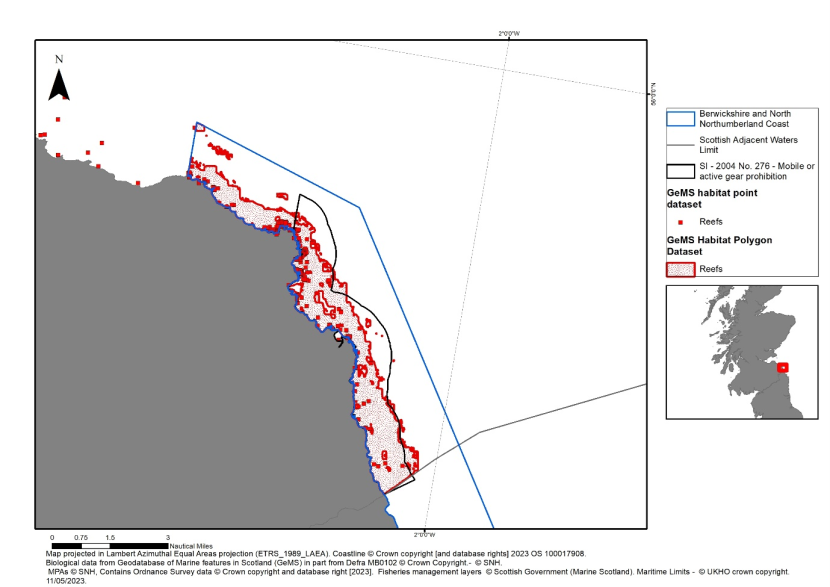
Figure 1. Map of Berwickshire and North Northumberland Coast showing the updated reef extent and reef point data in Scottish waters.
NatureScot advice
In light of our revised understanding of the extent of the reef features within the site, it is our view that the current management measure which restricts mobile gear within parts of the SAC does not fully protect the reef features for which the site is designated. This is particularly true in the areas of reef in the north-west of the site which the existing management measure does not cover. As such it is advised that consideration should be given to revising the existing fisheries management measure to ensure adequate protection is provided to the bedrock and stony reef features.
References
Miller, F., McCallum, S., White, A., Azzarello, J. & Caryl, F. 2017. Predictive mapping of seabed features within selected Special Areas of Conservation and Nature Conservation MPAs in Scottish territorial waters using available datasets. Scottish Natural Heritage Commissioned Report No. 980.