NatureScot additional management advice for demersal mobile/active fishing activities in the Sound of Barra SAC
Please note - The advice below was produced in May 2022 to assist the development of proposed management measures for fishing activity for MPAs. Further considerations were made by Marine Directorate and the final proposed management measures being consulted upon in 2026 are available via Scottish Government’s website.
May 2022
Background
The advice below was provided to Marine Directorate as a series of emails to outline our views on the feasibility of zoning options for demersal mobile/active fishing gear in the Sound of Barra SAC, with particular consideration of reef and the maerl beds and seagrass beds of the subtidal sandbanks as protected features of the site. This advice has been brought together in this document for ease of presentation for the 2025 consultation on MPA and PMF management measures.
This advice supplements that for demersal mobile/active gear in relation to the protected habitats of the site. It is provided in Table 2 of NatureScot’s Conservation and Management Advice, which is as follows
- Reefs - Remove or avoid pressures is recommended.
- Subtidal sandbanks - Remove or avoid pressures is recommended where maerl beds and seagrass beds are present. Spatial exclusion of demersal mobile/active gear is recommended in the areas of these habitats within the site. Reduce or limit pressures is recommended in all other areas. This may be achieved through spatial/temporal restrictions or other measures that reduce the pressure across other areas of subtidal sandbank substrate.
Extent of protected features, application of buffers and advice to Marine Directorate
Maps were produced using the most up to date point and polygon data from GeMS (Geodatabase of Marine features adjacent to Scotland) (as of May 2022) for the protected features within the Sound of Barra SAC which have remove or avoid management advice, i.e. reefs, maerl beds and seagrass beds. A 100 m buffer was applied around the maerl beds and seagrass beds (see pale pink areas, Figure 1). The 100 m buffer area was calculated based on the as the depth of the feature (25 m) multiplied by 4, based on the warp length-depth ratio within the JNCC boundary setting guidance[1]. A depth of 25 m was selected as these features generally occur shallower than 25 m. Based on these habitats alone, it was noted that there are some areas that might have the potential to be accessible on the east side.
Reef is also a protected feature and forms a complex mosaic with the subtidal sandbanks, including the maerl beds and therefore the 100 m buffer (as per above) was generated around the reef polygon data and added to the mapping (see light blue areas, Figure 2).
The result of the adding the buffers to the reef, along with those for maerl beds and seagrass beds, is that there are no areas remaining that could be accessible to dredging without interacting with the features and their buffers, apart from in the central area, which we understood was not the area of interest for scallop dredging activity. We suggested to Marine Directorate that more work could be done to plot these maps with more accurate buffering in areas where the features occur at shallower depths than 25 m.
Based on this information, NatureScot considers that zoning of dredging within the SAC is not a feasible option without risking the achievement of the conservation objectives for reef and subtidal sandbank (maerl beds and seagrass beds) features.
[1] JNCC. 2012. UK guidance on defining boundaries from marine SACS for Annex I habitats fully detached from the coast.
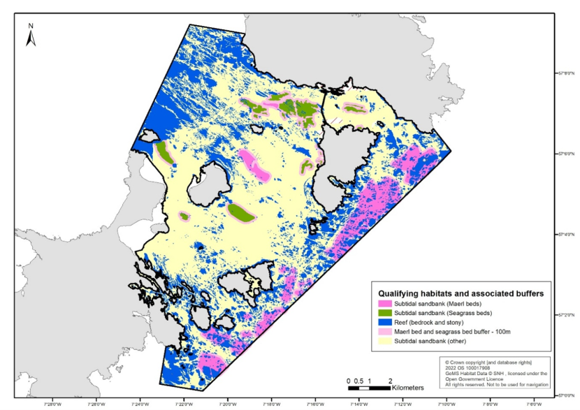
Figure 1. Map of the Sound of Barra Special Area of Conservation showing the extent of maerl beds, seagrass beds, subtidal sandbanks, and reef, along with the 100 m buffer area for maerl beds and seagrass beds.
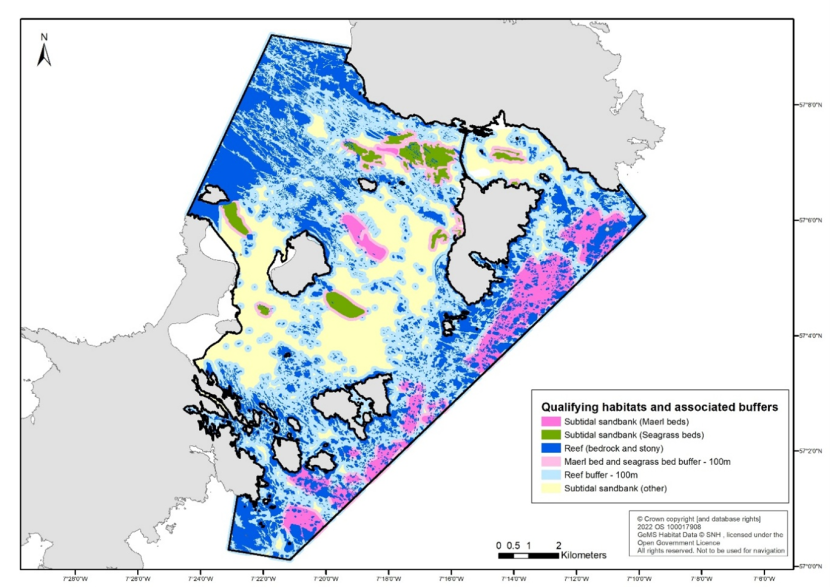
Figure 2. Map of the Sound of Barra Special Area of Conservation showing the extent of maerl beds, seagrass beds, subtidal sandbanks, and reef, along with the associated 100 m buffer areas.
Zoned options explored but not considered sufficient to meet the conservation objectives
Examples of possible zoning options were shared by NatureScot to Marine Directorate for Ministers consideration, along with the advice that both options would pose a risk to achieving the conservation objectives of the SAC.
Illustrative option A (see Figure 3) suggests a restriction of mobile demersal fishing in the central area of the sound, leaving the eastern edge open.
- It would leave approx. 695 ha of maerl beds exposed to mobile demersal fishing activity. There are approx. 770 ha of maerl beds in the Sound of Barra SAC boundary, so 90.2 % of the beds would still be exposed.
- It would leave approx. 1387 ha of reef in the outer area potentially exposed to mobile demersal fishing activity (noting that whilst dredgers won’t be targeting this habitat specifically there is potential for interaction with this habitat, in particular the stony reef). There is approx. 3645 ha of reef in the Sound of Barra SAC boundary, so 38 % would still be exposed.
Illustrative option B (see Figure 4) is as option A but with additional restrictions over the maerl beds (including a maerl bed buffer of 100 m) along the eastern edge.
- This would protect all of the maerl bed polygons within the site, although there would be some point data left exposed as illustrated on the map (Figure 4).
- It would also protect some but not all of the reef polygons on this eastern edge. Approx. 1170 ha would be left exposed, which is 32 % of the reef in the SAC boundary.
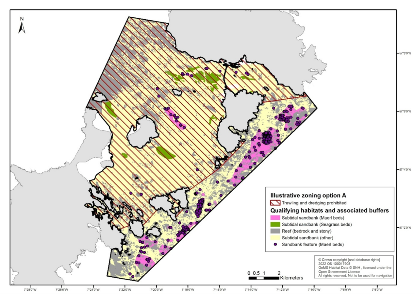
Figure 3. Map of the Sound of Barra Special Area of Conservation showing the illustrative zoning option A, with polygon data for seagrass beds, subtidal sandbanks, and reef, and both polygon and point data for maerl beds.
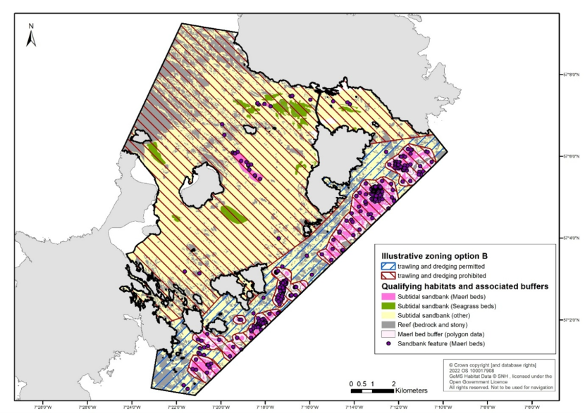
Figure 4. Map of the Sound of Barra Special Area of Conservation showing the illustrative zoning option B, with polygon data for seagrass beds, subtidal sandbanks, and reef, and both polygon and point data for maerl beds.