Supplementary paper on sandeel and herring distribution data to support MPA fisheries management measure advice and development
Please note - The advice below was produced (February 2023) to assist the development of proposed management measures for fishing activity for MPAs and PMFs (11 most sensitive to bottom contact gear) outwith MPAs. Further considerations were made by Marine Directorate and the final proposed management measures being consulted upon in 2026 are available via Scottish Government’s website.
February 2023
Purpose
This paper has been drawn together to supplement the discussion paper produced by NatureScot considering sandeels and herring and their habitat, informing their protection as a protected feature and as a key prey species of protected features of MPAs (including SPAs, SACs and NCMPAs). This paper aims to outline the available data/information sources for sandeel and herring distribution and their supporting habitats, the caveats associated with these data and which sources we should be using to support any consideration of fisheries management measures of these species in MPAs. The paper also uses examples of MPAs in which sandeels are designated as a protected feature to demonstrate the applicability of various models and other data.
This paper should be considered alongside the NatureScot Discussion paper on sandeel and herring sensitivities in relation to MPA fisheries management measure advice. In addition to these papers is the NatureScot & JNCC (2019) Sandeel fisheries guidance.
Sandeels
2.1 Sandeel Habitat
Five species of sandeel are found in Scottish waters, but two species of lesser sandeel are considered to be the most common, Ammodytes tobianus and Ammodytes marinus. Typically, A. tobianus are found in shallower waters, whilst A. marinus have been observed in a typical range of between 12-120 m (Wright et al., 2000). A. marinus is the more abundant species in Scottish waters and has been subject to fisheries in both the North Sea and on the West Coast.
Sandeels are dependent on their habitat, relying on typically sandy grounds to provide a suitable substrate for the burying behaviour exhibited overnight and during the winter months. During the winter buried period, sandeels will emerge to spawn their eggs onto sand, typically between December and February, the eggs then hatch in February to April (Wright and Bailey, 1996) and are dispersed more widely remaining planktonic for up to 10 weeks, after which juveniles seek out suitable areas of sand (Proctor et al., 1998).
2.2 Distribution data for sandeels and their habitat
There are various data sources available when considering sandeels and their habitat, including direct observations, areas derived from fishery/expert opinion and modelled outputs. The data we have available and how they have been utilised in our advice is outlined below. Due to the availability of data and their, in some cases, fisheries focus particularly with the older records, most of these sources focus on the lesser sandeel (A. marinus). Records for A. tobianus have also been included where possible.
2.2.1 Lesser Sandeel (Ammodytes marinus) - Celtic Seas/North Sea - Predicted density of buried sandeels (number per m2) and probability of buried sandeels by Langton et al., (2021)
In this study, species distribution models were developed to predict the presence and density of lesser sandeels (Ammodytes marinus) in parts of the North Sea and Celtic Seas regions. A hurdle model was found to be the best fitting model with the highest predictive performance; model evaluation with independent data demonstrated that it had significant discrimination ability across the study region. Data are available from Marine Scotland[1] (see Figure 1).
Model limitations are acknowledged in the report related to the training data used to inform the model, which were grab surveys from the Firth of Forth. In particular depth is highlighted in the report as being a weakness in the model. A. marinus has a preferred depth range of 30-50 m, but can occur between depths of 12-120 m. Some areas such as Turbot Bank are found at depths outside this range and were not represented by the equivalent in the dataset.
In 2021, MSS conducted a sandeel survey on the West Coast of Scotland (1321A) aiming at assessing sandeel presence and abundance in areas within and around the Sea of Hebrides, Shiant East Bank and North East Lewis MPAs. Sandeels were found at a number of stations (Figure 2) at levels comparable to stations on the east coast of Scotland. In addition, the effectiveness of the Langton et al., (2021) model was assessed by verifying sandeel presence (Figure 3). The model was found to have a good predictive power as sandeels were found at sites where their presence was predicted with a probability superior to 0.
[1] https://marine.gov.scot/node/21413
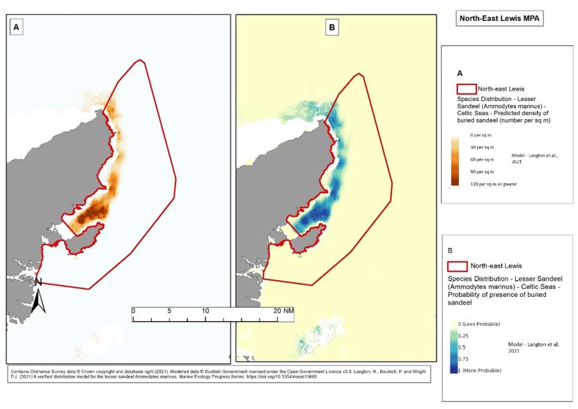
Figure 1. Example of lesser sandeel modelled data from Langton et al. (2021) overlapping with the North-east Lewis MPA, demonstrating A – Probability of buried lesser sandeel and B – Predicted density of lesser sandeel (per m2).
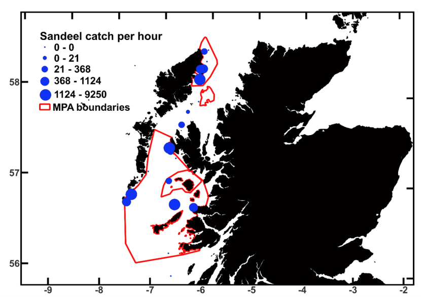
Figure 2: Local abundance indices (number of sandeel caught per hour) for the sandeel dredge tows of 1321A.
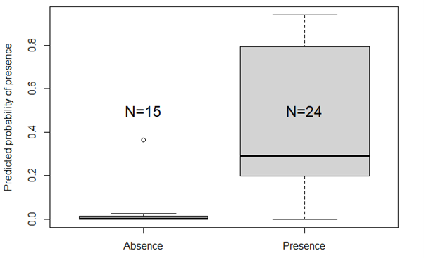
Figure 3: Predicted presence probability of sandeels (from Langton et al. 2021) at sites sampled (and where sandeels were present or absent) during survey 1321A on the West coast of Scotland.
2.2.2 Geodatabase of Marine features adjacent to Scotland (GeMS) – PMF point data (presence)
Data of recorded presence of sandeels held within GeMS includes those records identified as Ammodytes, Ammodytes marinus, Ammodytes tobianus and Ammodytidae. These are collated from multiple sources with credits to Crown copyright (Centre for Environment Fisheries and Aquaculture Science; Marine Scotland; Joint (NatureScot, Natural Resources Wales and Natural England) - former NCC data; Joint (NatureScot, Universities of St Andrews and Heriot-Watt); Joint Nature Conservation Committee; Lothian Divers/ Marine Conservation Society (Scotland); Marine Conservation Society (Scotland); NatureScot; NatureScot (derived from Marine Scotland Science video); Porcupine Marine Natural History Society; Queen's University Belfast; Scottish Environment Protection Agency. See Figure 4 for an example. These data were used as part of the evidence for designating Mousa to Boddam MPA and North-east Lewis MPA including sandeel as a feature.
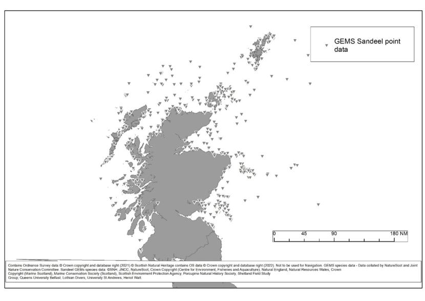
Figure 4. GeMS Sandeel point records including Ammodytes spp., Ammodytes marinus and Ammodytes tobianus.
2.2.3 Predicted Sandeel Habitat
Information/data on suitability of sediments as sandeel habitat were collated by Marine Scotland Science (MSS). These data were collected at the same time as information on adult sandeels presence/absence. Both datasets were entered into a General Additive Model (GAM) to derive information on sediment suitability for colonisation of sandeels (Wright et al., 2000). The spatial dataset incorporates seabed samples from the BGS, assessed by MSS. Advice from MSS suggests that the modelling undertaken as part of this has been superseded by work undertaken as part of the Langton et al. (2021) model. However, due to its role in the MPA designation process, and indication of sampled unsuitable habitat it has been included when assessing available data for sandeels. Figure 5 demonstrates the areas identified as suitable sandeel substrate.
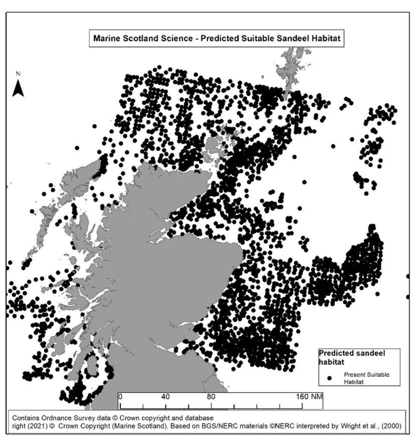
Figure 5. Predicted sandeel habitat data based on Marine Scotland Science GAM.
2.2.4 Scottish Coastal Sandeel grounds
A data set identifying Scottish coastal sandeel grounds (areas which were historically fished for the species) identified by J. Gauld (FRS now MSS) in the 1980s was delineated from advice from Peter Wright (MSS) and used as part of the basis for developing the Mousa to Boddam MPA and North-east Lewis MPA (see Figure 6). They are contained within GeMS.
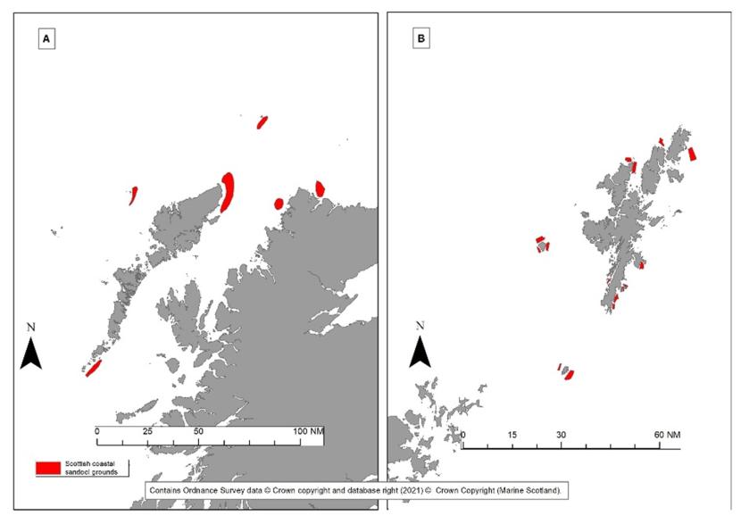
Figure 6. Scottish Coastal Sandeel Grounds (red) based on historic practices and expert opinions (MSS). Two key areas included A – West Coast of Scotland, B – Shetland.
2.2.5 Larval surveys
Data for larval density and distribution collated and analysed by Proctor et al. (1998) (contained within GeMS) consists of data from Marine Scotland Science and further published studies. Data from the different sources were not directly comparable with one another (e.g. sampling gear differences) and therefore they were combined into a comparable index of early larval abundance within a grid system (see Figure 7). Newly emerged larval sandeel abundance data from Proctor et al. 1998 were also used as part of North-east Lewis MPA designation process (see Figure 9).
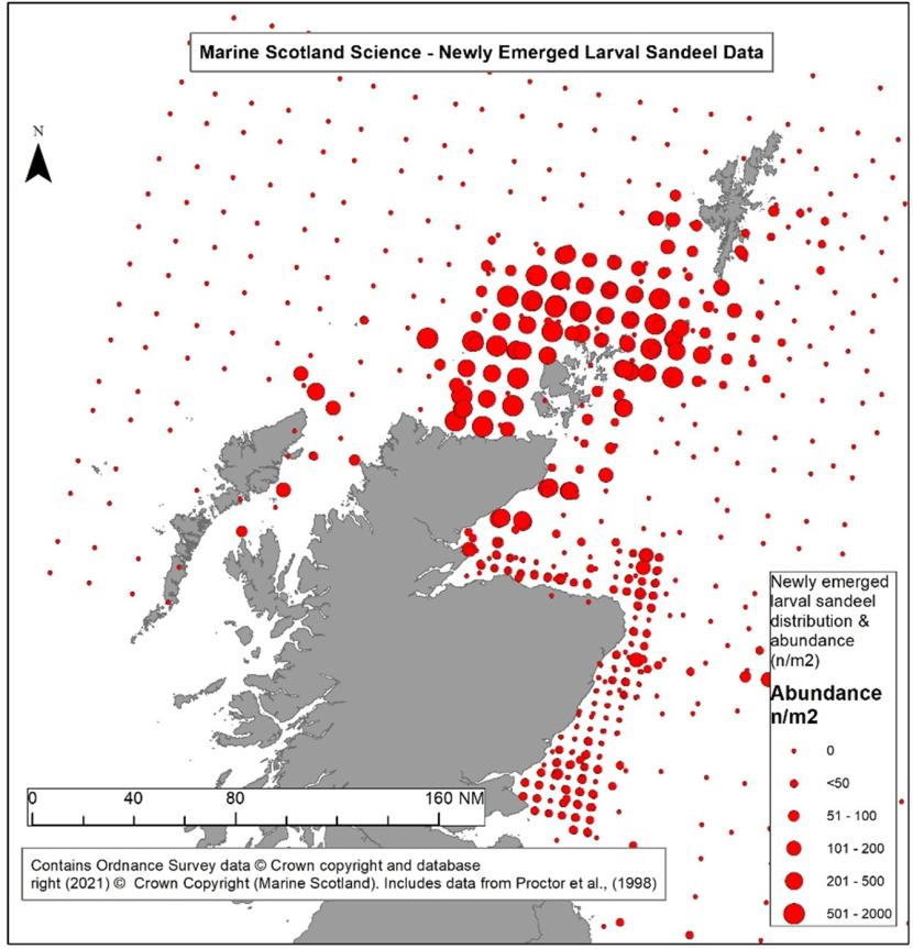
Figure 7. Newly emerged larval sandeel data, produced by collated by MSS as part of Proctor et al., 1998.
2.3 Data comparison
To compare the datasets and understand areas of agreement/divergence four datasets overlapping with four MPAs which have sandeel as a protected feature were examined. Figures 8-11 show those data sources outlined above overlaid with the four MPAs, namely Mousa to Boddam, North-East Lewis, North-West Orkney and Turbot Bank. Section A of the maps show the compiled data from those sources identified above. Section B shows those areas (in red) not included in the Langton et al. (2021) model, which were excluded on the grounds of unsuitable sediment type (rock), based on outputs from the JNCC’s semi-automated mapping of rock in the North Sea (JNCC, 2016) and Irish Sea, Minches Western Scotland and Scottish continental shelf (JNCC, 2017). Section C of the maps shows the bathymetry surrounding the MPA, based on DEFRA’s Digital Elevation Model (DEFRA, 2017), highlighting sandeels' preferential depth (30-50 m) in green and possible depth range (12-30 m and 50-120 m) in blue.
Figures 8-11 highlight a number of differences in the datasets examined. Of particular interest are differences between the Langton et al., (2021) predicted density model and those based on observed/sampled sandeels and expert knowledge.
Within the Mousa to Boddam MPA the Langton et al (2021) model identifies predicted buried sandeels in the vicinity of the Isle of Mousa, however not within either areas designated, unlike the sandeel records (from the GeMS database) or the coastal sandeel ground dataset which overlap with the protected area. Differences here may be due to the depth at the Boddam part of the site, which falls within the known range for sandeels, but not within the ‘preferred depth’ of 30-50 m or that found within the training dataset for the model. Differences at the Mousa part of the site may be a result of the habitat data feeding into the model, which excluded those areas identified as rock on the basis of the JNCC semi-automated model. Habitat around Shetland has previously been identified as including patches of sand mixed in amongst rocky areas. The resolution of the rock layer which limited the extent of the model may have excluded some of these areas where small sandeel grounds have previously been identified, as described in Wright (1996).
At the North-east Lewis MPA the northern part of the site is based around a key Scottish coastal sandeel ground (described above). Sandeel records also identify areas where sandeels have been sampled (to the east of the site) and suitable habitat (in the north of the site). The Langton et al. (2021) model identifies areas of predicted buried sandeels inshore. The areas identified by the model do not overlap directly with the Scottish coastal sandeel grounds layer, and this may again be due to the depth of these areas falling outside the depth observed in the training data/that was predicted to be most preferential. Alternatively, it could reflect a difference in the locations of the fishery, which may have targeted feeding sandeels compared to buried sandeel distribution.
The Langton et al. (2021) model does not predict areas of buried sandeel within the North-West Orkney and the Turbot Bank MPAs. Parts of the North-west Orkney MPA are excluded from the model as they are either identified as rock or outside of the study area. Whilst Proctor et al. (1998) identifies newly emerged sandeel larvae at both sites and both sites show point records of sandeels collected on surveys, the sites fall outside the preferred depth ranges for A. marinus and may not have been reflected in the training data which informed the model. Both sites fall within the possible range at which A. marinus can occur.
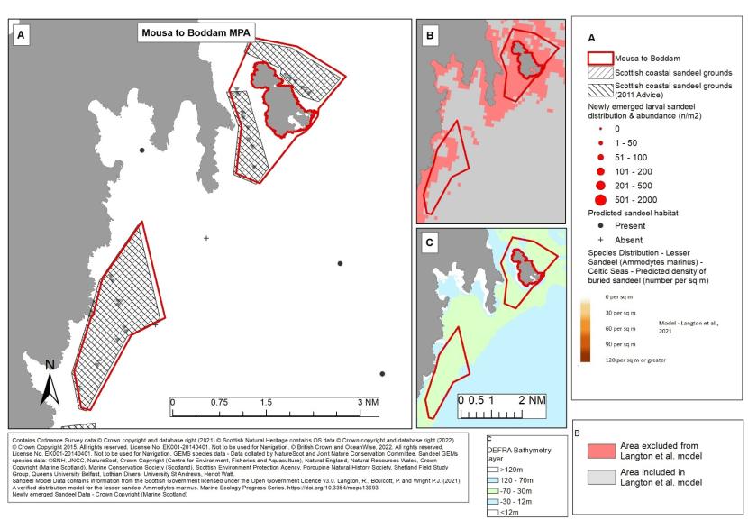
Figure 8. Available sandeel evidence for Mousa to Boddam MPA.
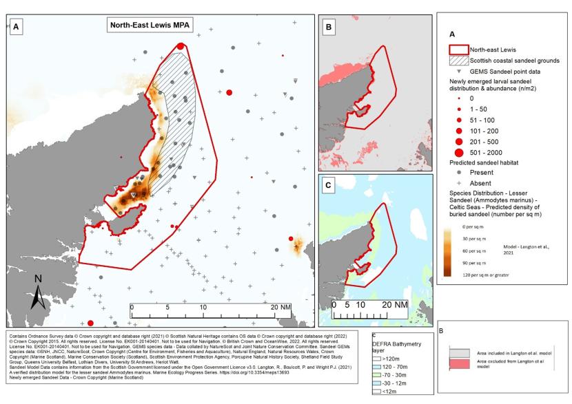
Figure 9. Available Sandeel evidence for North-east Lewis MPA.
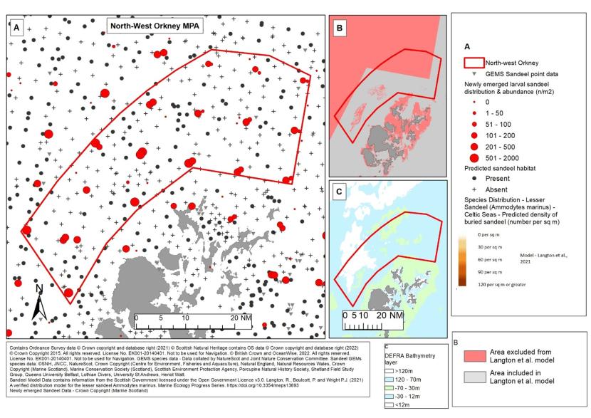
Figure 10. Available Sandeel evidence for North-West Orkney MPA.
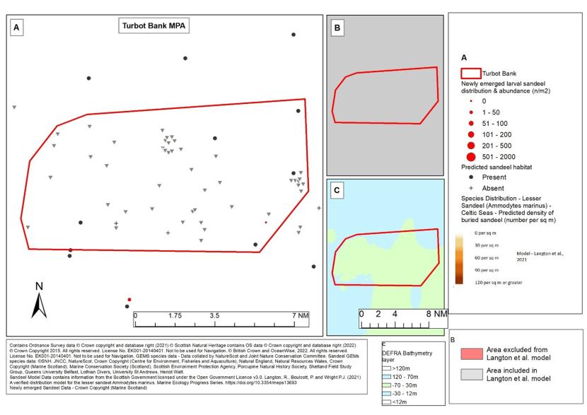
Figure 11. Available sandeel evidence for Turbot Bank MPA.
2.4 Key points relating to the use of sandeel data
Considering the various data sources and their application, it remains the case that multiple sources of data need to be considered on a site-by-site basis. There still remain caveats in the various datasets, however used in combination where there is suitable level of corroborative detail, they are likely to provide a good basis for identifying areas which require fisheries management measures. It should also be considered, when assessing the data sources in combination, that the different forms of data may demonstrate different aspects of sandeel ecology. The modelling undertaken in Langton et al. (2021) and the Marine Scotland Science predicted habitat model are focused around predicting buried sandeels or sediment suitable for burying and represent direct attempts to quantify ‘sandeel habitat’. Data from direct records or based on historic fishing activity could reflect sandeel feeding or foraging during the day, as opposed to sandeel buried at night (and at certain times of year), where certain gear types are more likely to catch sandeel, e.g. trawl. Whilst research suggests that whilst sandeel maintain a certain proximity to suitable burying habitat, feeding or foraging may take place several kilometres from the areas the sandeel bury in each night (van der Kooij et al., 2008; Wright et al., 2019). Sandeel records that do not directly overlap with modelled data may not be contradictory but may reflect different aspects of their ecology.
The above sites have been used as an example to demonstrate the varying sources of data and their strengths/weaknesses. Site-by-site analysis has been undertaken considering the various data sources available for relevant SPAs, SACs and MPAs where sandeel is a protected feature or considered to be a key prey species of the protected features. For each of these sites documents have been produced which provide an appraisal of the relevant data. A summary of these sites has been provided in Annex I of this document.
Herring
3.1 Herring spawning habitat
Frost and Diele (2022) provide an overview of the current knowledge on Atlantic herring (Clupea harengus) spawning grounds in Scotland. Atlantic herring are demersal spawners and exhibit fidelity to spawning season and grounds. They lay their sticky eggs directly onto the seabed where they are then fertilised. They have a preference for areas of coarse substrates e.g. gravel, coarse sand, shells, maerl beds and small stone. They tend to aggregate around their spawning grounds for some time before spawning (Maravelias et al., 2000). In the offshore areas of Scottish waters spawning occurs in the autumn but inshore it occurs mainly in the spring, although there is some overlap.
3.2 Distribution data for herring and their spawning habitat
It is recognised in many research papers that direct observations or sampling in-situ is the best method of identifying herring spawning habitats. Figures 12 and 13 include examples of limited areas where herring spawning grounds have been identified based on these types of currently accessible data. The areas identified south of Arran 9Figure 13), which have been subject to survey (Morrison et al., 1991) and an area in the Inner Sound (between Loch Torridon and Loch Gairloch) (Figure 12) which were surveyed with DDV and identified mats of herring eggs interspersed with the maerl bed (Shucksmith et al., 2021). Due to the rarity of these findings, other methods have often been used to identify spawning areas. Techniques including the presence of young larvae, catch data of spawning herring or fishing predating on eggs, have been used in an attempt to derive additional information. These techniques, whilst indicative of a proximity to egg-laying habitat, often lead to the identification of broad areas, within which individual spawning grounds will be based, but they also incorporate large areas of unsuitable habitat (Frost and Diele, 2022). Table 3 provides a summary of these known data sources.
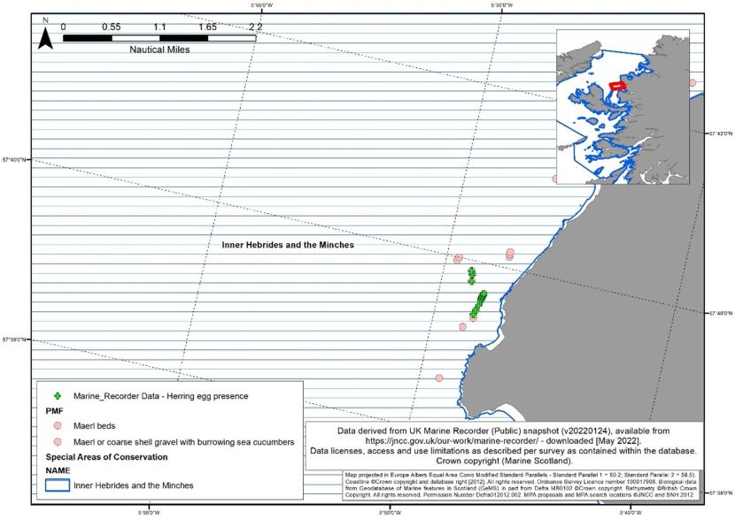
Figure 12. Data from DDV in the Inner Sound where herring egg presence was recorded interspersed with maerl bed records.
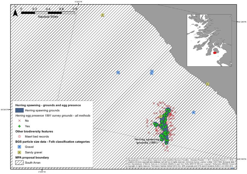
Figure 13. Data identified as herring spawning grounds based on sampling detailed in Morrison et al. (1991).
| Data Sources | Description | Links |
|---|---|---|
Coull et al., 1998.
Coull, K. A., Johnstone, R. and Rogers, S. I. (1998) 'Fisheries Sensitivity Maps in British Waters. Published and Distributed by UKOOA Ltd'.
| During the late 1990s, a collaborative project between the national fisheries laboratories (CEFAS and the then Fisheries Research Services, Aberdeen), the UK Offshore Operator's Association (UKOOA), the Scottish Fishermen's Association (SFF) and the National Federation of Fishermen's Organisations (NFFO) produced the Fisheries Sensitivity Maps in British Waters.
Sensitivity maps for spawning herring based on distribution of eggs, larvae and young and commercially sized fish combined with sediment/seabed information.
| |
Ellis et al. 2012
Ellis, J. R., Milligan, S. P., Readdy, L., Taylor, N. and Brown, M. J. (2012) 'Spawning and nursery grounds of selected fish species in UK waters. Sci. Ser. Tech. Rep., Cefas Lowestoft, 147: 56 pp
| Update to Coull et al. (1998), work and overlaid the most recent larval data from the ICES programme of international herring larval surveys (IHLS).
| Report |
Aires et al. 2014
Aires C, Gonzalez-Irusta JM, Watret R (2014) Updating fish- eries sensitivity maps in British waters. Scottish Mar Freshw Sci 5:1–89
| Further update to sensitive fisheries area work. Does not define spawning/nursery areas however, focuses on those areas where there is evidence of aggregations of 0 group fish and/or larvae. Herring maps use data from the IHLS, and species distribution models.
| |
Frost and Diel 2022
Frost, Michelle & Diele, K. (2022). Essential spawning grounds of Scottish herring: current knowledge and future challenges. Reviews in Fish Biology and Fisheries. 32. 1-24. 10.1007/s11160-022-09703-0.
| Aim to identify Herring Spawning Grounds through comprehensive review of historic literature sources, scientific databases and fisher interviews. Produced from work as part of the West of Scotland Herring Hunt (WOSHH).
| |
ScotMer (as yet unpublished) Developing Essential Fish Habitat maps for fish and shellfish species in Scotland.
| ScotMer funded essential fish habitat (EFH) project looking at modelling (where possible) or habitat proxies for various important commercial species identifying key habitats based on specific life stages (predominantly spawning/nursery). Not currently published.
| Report not yet published.
|
MSS ongoing research project
Collaborative project. | Ongoing research based on 46 years (1972-2017) of herring larvae catch data held by ICES with herring age model (to relate larval size to age) and particle tracking simulations of larvae to identify potential herring spawning grounds across Scottish Shelf Seas.
| Report/Data not yet published.
|
Data from Aires et al., (2014) and Coull et al., (1998) have been include in Figure 14. This demonstrates the broad areas identified by Coull et al., (1998) based on survey data of eggs, larvae and young commercial fish. Aires et al., (2014) represents attempts to model herring larvae aggregations, however the authors of the work cautioned on the use as a direct proxy for spawning due to the lack of suitable environmental data in coastal areas and the unknown timespan between spawning and surveying, resulting in lower certainty in the model.
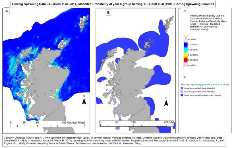
Figure 14. Examples of attempts to identify areas of herring spawning grounds using proxy information.
3.3 Data comparison
Frost and Diel (2022) collated and described various herring spawning grounds using information including direct visual observations or sampling of spawn from the seabed, positions of recently hatched or young larvae, records of catch locations of ‘ripe’ herring and records of catch locations of fish that have fed on. Work is currently underway as part of a ScotMer essential fish habitat (EFH) project which aims to develop high quality essential fish habitat models for Scotland and where this isn’t possible, apply viable alternatives, e.g. habitat proxies for EFH functions. Further work is also ongoing by Marine Scotland Science to infer spawning locations from particle dispersal models and data derived from the International Herring Spawning Surveys. More detailed analysis of the work highlighted above will be possible on completion of ongoing work.
Where direct observation / sampling data of herring spawning is available a high degree of confidence can be associated with these areas because these areas have been used as spawning grounds and given the right conditions, the area will continue to be suitable. Where directly sampled data is not available, locations could be inferred from proxy or modelled data sets (as outlined above), however careful scrutiny of the caveats associated with each dataset would be necessary. The use of a combination of such datasets would give higher confidence, as is likely that no single data source will provide a complete picture used in isolation due to differences between them. Differences in the datasets may depend on a variety of factors (sampling methods, available data etc.) and it is likely that these will need to be considered on a site-specific basic to determine the most appropriate data sources for a particular area.
Annex 1
| Site | Type of MPA | Role of Sandeel | Assessment of Habitat |
|---|---|---|---|
| Ailsa Craig SPA | Colony SPA | Prey Species (Designated Bird Species) | No habitat - corroborative data sources |
| Buchan Ness To Collieston Coast SPA | Colony SPA | Prey Species (Designated Bird Species) | No habitat – Data available for wider area indicating sandeel occur outside of site. |
| Calf of Eday SPA | Colony SPA | Prey Species (Designated Bird Species) | Sandeel habitat – Data limited to modelled data only. |
| Canna and Sanday SPA | Colony SPA | Prey Species (Designated Bird Species) | No habitat |
| Cape Wrath SPA | Colony SPA | Prey Species (Designated Bird Species) | Sandeel habitat – Modelled data only – coverage for half of site |
| Copinsay SPA | Colony SPA | Prey Species (Designated Bird Species) | Sandeel habitat – Modelled data only |
| East Caithness Cliffs SPA | Colony SPA | Prey Species (Designated Bird Species) | Sandeel habitat – Modelled data only |
| Fair Isle SPA | Colony SPA | Prey Species (Designated Bird Species) | Sandeel habitat – Modelled data only |
| Fetlar SPA | Colony SPA | Prey Species (Designated Bird Species) | Sandeel habitat – Modelled data only, records of Raitt’s sandeel |
| Flannan Isles SPA | Colony SPA | Prey Species (Designated Bird Species) | Sandeel habitat – Data based only on expert opinion/historic activity |
| Forth Islands SPA | Colony SPA | Prey Species (Designated Bird Species) | Limited Sandeel habitat – Sandeel records and limited modelling data |
| Foula SPA | Colony SPA | Prey Species (Designated Bird Species) | Sandeel habitat – Modelled data, sandeel records and expert opinion/historic activity. |
| Fowlsheugh SPA | Colony SPA | Prey Species (Designated Bird Species) | No habitat |
| Handa SPA | Colony SPA | Prey Species (Designated Bird Species) | No habitat |
| Hermaness, Saxa Vord and Valla Field SPA | Colony SPA | Prey Species (Designated Bird Species) | No habitat |
| Hoy SPA | Colony SPA | Prey Species (Designated Bird Species) | Sandeel habitat – Modelled data and limited some sandeel records |
| Marwick Head SPA | Colony SPA | Prey Species (Designated Bird Species) | No habitat |
| Mingulay and Berneray SPA | Colony SPA | Prey Species (Designated Bird Species) | Sandeel habitat – Modelled data supported by expert opinion/historic activity. |
| North Caithness Cliffs SPA | Colony SPA | Prey Species (Designated Bird Species) | Sandeel habitat – Modelled data. Record of Raitt’s sandeel. |
| North Colonsay and Western Cliffs SPA | Colony SPA | Prey Species (Designated Bird Species) | Sandeel habitat – Modelled data. |
| North Rona and Sula Sgeir SPA | Colony SPA | Prey Species (Designated Bird Species) | Sandeel habitat – Limited modelled data and expert opinion/historic activity. |
| Noss SPA | Colony SPA | Prey Species (Designated Bird Species) | Sandeel habitat – Limited modelled data and expert opinion/historic activity. |
| Rousay SPA | Colony SPA | Prey Species (Designated Bird Species) | Sandeel habitat – modelled data, records of Raitt’s sandeel. |
| Rum SPA | Colony SPA | Prey Species (Designated Bird Species) | No sandeel habitat – limited predictions from modelled data. |
| Shiant Isles SPA | Colony SPA | Prey Species (Designated Bird Species) | No sandeel habitat. |
| St Abbs Head to Fast Castle SPA | Colony SPA | Prey Species (Designated Bird Species) | No sandeel habitat – records of Raitt’s sandeel inshore, limited data to discern habitat. |
| St Kilda SPA | Colony SPA | Prey Species (Designated Bird Species) | Sandeel habitat – Limited modelled predictions. |
| Sule Skerry and Sule Stack SPA | Colony SPA | Prey Species (Designated Bird Species) | No sandeel habitat – single point of modelled data. |
| Sumburgh Head SPA | Colony SPA | Prey Species (Designated Bird Species) | Sandeel habitat – Expert opinion/sandeel records. |
| Troup, Pennan and Lion's Head SPA | Colony SPA | Prey Species (Designated Bird Species) | No sandeel habitat – Limited modelled predictions, records of Raitt’s sandeel. |
| West Westray SPA | Colony SPA | Prey Species (Designated Bird Species) | Sandeel habitat – Modelled data supported by presence of larval data. |
| Bluemull and Colgrave Sound SPA | Marine SPA | Prey Species (Designated Bird Species) | No sandeel habitat – Limited modelled predictions, no supporting data. |
| Coll and Tiree SPA | Marine SPA | Prey Species (Designated Bird Species) | Sandeel habitat – Agreement in modelled data. |
| East Mainland Coast, Shetland SPA | Marine SPA | Prey Species (Designated Bird Species) | Sandeel habitat – Modelled data with limited predictions. |
| Moray Firth SPA | Marine SPA | Prey Species (Designated Bird Species) | Sandeel habitat – Modelled data, sandeel records, larval data indicate presence of habitat. |
| North Orkney | Marine SPA | Prey Species (Designated Bird Species) | Sandeel habitat – Modelled data predictions in discrete areas. |
| Outer Firth of Forth and St Andrews Bay Complex | Marine SPA | Prey Species (Designated Bird Species) | Sandeel habitat – Modelled data, sandeel records and sandeel larvae indicate presence of habitat. |
| Scapa Flow SPA | Marine SPA | Prey Species (Designated Bird Species) | Sandeel habitat – Modelled data, 2 sandeel records. |
| Seas off Foula SPA | Marine SPA | Prey Species (Designated Bird Species) | TBC |
| Seas off St Kilda SPA | Marine SPA | Prey Species (Designated Bird Species) | TBC |
| Sounds of Gigha | Marine SPA | Prey Species (Designated Bird Species) | Sandeel Habitat – Discrete area identified by modelled data. |
| Solway Firth | Marine SPA | Prey Species (Designated Bird Species) | Sandeel Habitat – Modelled data and sandeel records |
| West Coast of the Outer Hebrides | Marine SPA | Prey Species (Designated Bird Species) | Sandeel Habitat – modelled data, limited larval data. |
| Ythan Estuary, Sands of Forvie and Meikle Loch | Marine SPA | Prey Species (Designated Bird Species) | Sandeel Habitat – modelled data and sandeel records. |
| Moussa to Boddam | NC MPA | Protected Feature (Sandeels) | Sandeel Habitat – Expert opinion/historic activity and sandeel records. |
| North-East Lewis | NC MPA | Protected Feature (Sandeels) | Sandeel habitat – Modelled data, expert opinion/historic activity and sandeel records. |
| Seas of the Hebrides | NC MPA | Prey Species (Minke Whale) | Sandeel habitat – Modelled data, expert opinion/historic activity and sandeel records. |
| Southern Trench | NC MPA | Prey Species (Minke Whale) | Sandeel habitat – Modelled data and sandeel records. |
| Inner Hebrides and the Minches | SAC | Prey Species (Harbour Porpoise) | Sandeel habitat – Modelled data and sandeel records. |
References
Aires C, Gonzalez-Irusta JM, Watret R (2014) Updating fisheries sensitivity maps in British waters. Scottish Marine and Freshwater Science 5:1–89
Coull, K. A., Johnstone, R. and Rogers, S. I. (1998) Fisheries Sensitivity Maps in British Waters. Published and Distributed by UKOOA Ltd'.
Eleftheriou A. and Robertson M.R. 1992 The effects of experimental scallop dredging on the fauna and Physical environment of a shallow sandy community. Netherlands Journal of Sea Research 30: 289-299
Ellis, J. R., Milligan, S. P., Readdy, L., Taylor, N. and Brown, M. J. (2012) 'Spawning and nursery grounds of selected fish species in UK waters. Sci. Ser. Tech. Rep., Cefas Lowestoft, 147: 56 pp.'.
Frost, M. & Diele, K.. (2022). Essential spawning grounds of Scottish herring: current knowledge and future challenges. Reviews in Fish Biology and Fisheries. 32. 1-24. 10.1007/s11160-022-09703-0.
Langton, R & Boulcott, P. & Wright, P. (2021). A verified distribution model for the lesser sandeel, Ammodytes marinus. Marine Ecology Progress Series. 667. 10.3354/meps13693.
Morrison, J.A., Napier, I.R. and Gamble, J.C. (1991). Mass mortality of herring eggs associated with sedimenting diatom bloom. ICES Journal of Marine Science 48: 237-245.
Proctor, R., Wright P.J., Everitt A., Modelling the transport of larval sandeels on the north-west European shelf, Fisheries Oceanography, 1998, vol. 7 (pg. 347-354)
Shucksmith, R.J., Shelmerdine, R.L., and Shucksmith, R. 2019. Biological analyses of seabed imagery from within and around Marine Protected Areas in Orkney, Shetland, Inner Sound, and Islay and Jura in 2019. Scottish Marine and Freshwater Science Vol 12. No 2.
Tien, N.S.H., Craeymeersch, J., van Damme, C., Couperus, A.S., Adema, J. and Tulp, I. 2017. Burrow distribution of three sandeel species relates to beam trawl fishing, sediment composition and water velocity, in Dutch coastal waters. Journal of Sea Research 127: 194-202.
van der Kooij, Jeroen & Scott, Beth & Mackinson, Steven. (2008). The effects of environmental factors on daytime sandeel distribution and abundance on the Dogger Bank. Journal of Sea Research. 60. 201-209. 10.1016/j.seares.2008.07.003.
Wright PJ (1996) Is there a conflict between sandeel fisheries and seabirds? A case study at Shetland. In: Greenstree SPR, Tasker ML (eds) Aquatic predators and their prey. Fishing News Books, Blackwell Science, Oxford, p 154−165
Wright PJ, Bailey MC (1996) Time of hatching in Ammodytes marinus from Shetland waters and its significance to early growth and survivorship. Mar Biol 126:143–152
Wright, Peter & Jensen, H. & Tuck, Ian. (2000). The influence of sediment type on the distribution of the lesser sandeel, Ammodytes marinus. Journal of Sea Research. 44. 243-256. 10.1016/S1385-1101(00)00050-2.
Wright PJ, Christensen A, Regnier T, Rindorf A, van Deurs, M (2019) Integrating the scale of population processes into fisheries management, as illustrated in the sandeel, Ammodytes marinus. ICES J Mar Sci 76: 1453−1463.