SBAG Scottish Beaver Advisory Group Meeting - 21 August 2025 - Beavers and flood embankments workshop
Introduction
The Scottish Beaver Advisory Group (SBAG) convened a two-day workshop on 20–21 August 2025 to explore the interactions between beavers and flood embankments, with a focus on understanding risks, management challenges, and potential adaptive approaches. The event brought together representatives from the Scottish Government, NatureScot, SEPA, NFUS, SLE, Scottish Water, eLINK, RZSS, CNPA, LLTNPA, the Rewilding Alliance, Beaver Trust, River Restoration Centre, and Confor.
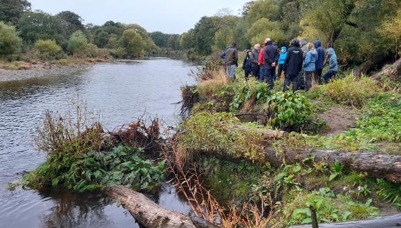
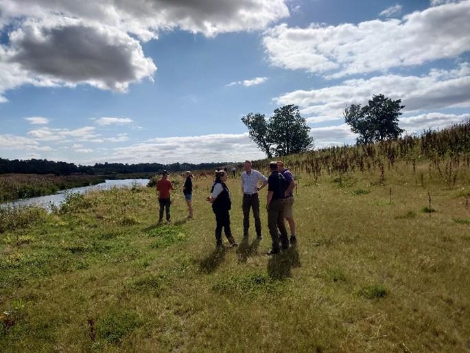
The workshop comprised field visits on 20 August to several sites along the River Isla, where participants engaged directly with local land managers to observe the impacts of beaver activity on flood protection infrastructure and discuss management responses. These site visits highlighted the practical and economic implications for farmland adjacent to embanked rivers.
On 21 August, the group held an indoor session featuring presentations from Dutch experts, SEPA, and river restoration specialists. Discussions centred on flood risk management policy, hydro-morphological processes, international best practice, and options for coexistence with beavers within managed river systems.
The workshop aimed to identify shared understanding and practical pathways to improve the resilience of flood embankments for agriculture while supporting Scotland’s commitments to nature recovery and sustainable land management. It concluded with agreement on several short, medium, and long-term actions for further exploration, including pilot projects, improved communication with land managers, and potential funding mechanisms to support adaptive floodplain management. This report provides an overview of the field visits, indoor presentations and concludes with the agreed recommendations.
Field Visits – 20 August
Brigton of Ruthven Farm
Participants visited a site with a flood bank on the river Isla that had breached on multiple occasions. The bank had been damaged in 2020, breached in November 2022 and during Storm Babet in 2023. The last breach had not yet been repaired, with discussions ongoing with SEPA. The land manger explained the economic impacts of repeated damage including repairs costs, crop losses, and impacts on land value and cropping choice.
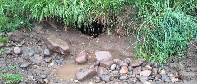
Burrow hole from the field side of the banking, extending to the river in 2020.
In order to understand the river dynamics at this location SEPA summarised the hydro-morphological characteristics of the River Isla, explaining that the upstream reaches are steeper, while this section is more depositional and meandering. He noted that this river has historically been subject to straightening and embankment, increasing its overall energy and sediment transport capacity.
SEPA noted that recent flow data from the downstream river gauge indicates an increased frequency of moderate flow events over the last 15 years. These events are sufficient to mobilise sediment and therefore flood embankments in this location are likely to be under increased pressure, regardless of beaver activity. SEPA advised that they can provide further guidance on the potential risks and benefits of gravel extraction here as a management option.
NatureScot, as a part of site visits in 2021, had invited the River Restoration Centre (RRC) to assess the area. RRC had made recommendations to set back riverbanks in order to enhance riparian management. The land manager indicated he would be open to considering such measures if there was funding for the actions and adequate payments to compensate for the loss of productive land.
Strathisla Farm
The next location for a site visit was to a site where a water gate and wing fencing had been installed in order to manage beavers impacts upstream. The group were met by the land owner. The installation of the water gate followed several years of consultation and design work, including flood risk assessments, baseline fish surveys, liaison with SEPA and with fisheries interests, design and engineering works, and the establishment of a formal agreement with Scottish Water who own the pipe bridge and concrete structure to which the water gate is attached. There is also a maintenance agreement with the land owner. The water gate has been in place since November 2023.
Beaver activity continues to be observed upstream of the water gate and trapping is ongoing to remove beavers from an area that is vulnerable to agricultural conflicts. Following which, the effectiveness of the water gate in reducing beaver colonisation will be monitored. To date, trail cameras have not detected any beavers crossing the water gate.
The landowner questioned whether the grill spacing, which is currently set 15 cm, would prevent beavers from recolonising. This spacing represents a carefully considered balance between restricting beaver passage and allowing salmon movement. The design was finalised following extensive consultation to meet the needs of both wildlife and water management objectives. The burn was electro-fished prior to the gate installation and will be monitored for a further 2 years (5 years in total) to allow an assessment of any impact on fish movement.
Mains of Keithick/Hills of Bendochy
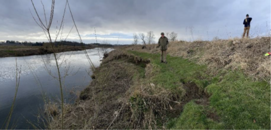
Finally, the group visited a site just upstream from Coupar Angus on the river Isla with the land owners/managers from wither side of the river. The flood banks had been breached on the Keithick side in Storm Babet and on the Hills of Bendochy side several times in recent years.
The site had previously been visited by NatureScot and the RRC, who recommended setting the flood banks back to reduce the likelihood of overtopping and beaver conflict. In 2022, NatureScot staff submitted a bid to the Nature Restoration Fund (NRF) to support the design works and costing of riverbank re-alignment along 4km of flood banks on a number of farms on the River Isla. This bid was unsuccessful, with feedback suggesting that a broader partnership approach would strength future applications. At the time, NFUS did not support the application because payments are not provided by NRF funding for loss of productive land.
In February 2024, one of the land owners had arranged for the flood bank to be moved back along 470m of river at his own cost, at a reported cost of £45 per metre (£25,000 in total). This work involved reprofiling and moving back the existing bank, without importing or removing material from the site.
The land owner noted that previous repairs had cost approximating £5,000 each time, and his decision to realign was made as a long-term, cost-effective investment to reduce future maintenance needs and safeguard the high value farmland behind the bank.
A section of flood bank on the River Isla in March 2022. copyright RRC
Click for a full description
1.5m height and less than 5m from water edge.
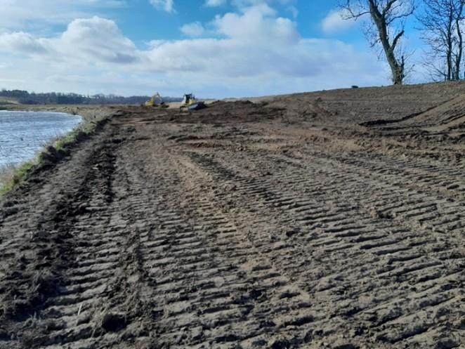
The same reach of the river February 2024 and August 2025 during and post bank re-alignment.
NatureScot presented some results of the 2024 beaver burrow surveys on the River Isla. These included both walkover assessments for above-ground signs and sonar surveys of the riverbed and banks. Across the 22km of banks surveyed, 177 burrows were detected, many of which were collapsed, reflecting the long history of beaver occupancy here and sandy bank substrates. The sonar survey found fewer burrows, likely representing active sites. A high density of scent mounts had also been observed and participants discussed the possibility that beaver removal might actually increase burrowing activity, with new beavers moving into vacant locations and digging fresh burrows. The possibility of thermal drone surveys was discussed, to supplement existing surveys of beaver populations.
Indoor Workshop - 21 August
As part of the indoor workshop, a series of presentations were delivered by national and international experts to share current knowledge and approaches to beaver management, flood risk and river restoration.
Beaver Management in the Netherlands
Hanneke Kloosterboer, Wiet van Bragt and Kees Schep from Regional Water Authorities in the Netherlands and STOWA
Representatives from the Dutch Regional Water Authorities and the Dutch Foundation for Applied Water Research (STOWA), outlined their approach to managing interactions between beavers and flood defence infrastructure. The presentation covered the National Action Plan, risk assessment methodology, inspection and repair regimes and preventative measures currently being implemented across The Netherlands.
Key points from the presentation included that while the government has responsibility for flood safety (critical levee infrastructure), damage to dykes is the responsibility of the landowner, hence there are also ongoing discussions about who pays for damage and compensation. Risks mapping is used to prioritise funding of protection/preventative measures as part of an existing programme for levee protection. Risk is assessed as ‘likelihood x impact’, which is used to assess the cost-benefit of different preventative approaches. Beaver monitoring is carried out along with muskrat trapping. In high water conditions in the winter, water boards have staff on beaver night patrols and carry out inspections of levees and reactive repairs. Longer-term interventions being trialed include levee reprofiling, hard engineering reinforcements and the creation of high-water refuges for wildlife.
The Dutch approach recognises beavers are afforded strict EU protection and that they will recolonise vacant areas and therefore seeks to live-with rather than remove beavers. However, beaver control has taken place in one water authority, with 200 beavers lethally controlled last year. Evidence suggests that burrow length is related to the stability of water levels and the location of high ground during high water levels. Participants discussed the effectiveness of shallower levee slopes and high-water refuges in deterring burrowing behaviour and promoting co-existence.
SEPA’s role Flood Risk and Morphology
Karin Bloodworth, Julie Holmes, Matt Burke
The SEPA team provided an overview of Scotland’s flood risk management framework, SEPA’s role and the implications of climate change for river management.
Responsibilities for Flood Risk Management are shared by a range of responsible authorities including SEPA, Local Authorities, Scottish Water and the National Parks. SEPA’s role relates to forecasting and warning services and strategic flood risk management.
Flood Risk Management Plans and Local Flood Risk Management Plans were first published in 2013 and are currently being reviewed. They primarily target Potentially Vulnerable Areas, through opportunities for natural flood management in agricultural settings are also identified. River Basin Management Planning is focused on improving water quality and addressing instream barriers, but prime agricultural land is typically excluded from restoration projects.
Under the controlled activities regulations (CAR), existing embankments can be maintained or repaired under the general binding rules, but new embankments would be controlled, and dredging can be permitted under licence following assessment. Flood risk is not regulated through CAR.
In the context of climate change, it is predicted that there will be wetter winters and less frequent but more intense summer rainfall. Local predictions for Perth suggest only slight changes to the number of wet days, but with these days being 15-30% wetter which will lead to more frequent high flows. River gauge data including Tay and Isla point to this trend in the last 15 years. This analysis supports the conclusion that maintaining rivers in their current form will be increasingly unsustainable. Giving rivers more space will allow them to dissipate increasing energy and reduce the maintenance burden.
River Restoration
Prof Richard Williams, Chief Scientist – Freshwater, Earth Science New Zealand and Honorary Professor at University of Glasgow
Prof Williams presented the riverscape concept, encouraging a shift from viewing rivers as static features to recognising them a dynamic, interconnected systems that continuously evolve across time and space.
River restoration can range from active intervention (such as re-meandering using machinery) to assisted recovery (using large woody debris) to passive, nature recovery approaches. Low energy rivers are more suited to greater intervention than high energy rivers. Hard engineering has cascading effects, because rigid protection structures can displace erosion and flood pressures downstream. SEPA data indicate that in Scotland, 4150km (17%) of rivers have been straightened, 1519 km (6%) of rivers have been embanked and 570km (2.3%) have bank protection.
Six river restoration case studies demonstrated that restored reaches can slow high-energy flows, helping to reduce downstream flood risk and enhance habitat diversity. Bank erosion was reframed as a natural and beneficial process in many contexts, except where it directly threatens critical infrastructure. Prof Williams emphasised the importance of long-term, catchment-scale thinking, advocating for river management approaches that work with natural processes, rather than perpetuating the maintenance of static, engineered systems.
Key Discussion Points
Strategic Approach to Flood risk
The group recognised that the pressures on agricultural flood banks should be viewed in the broader context of flood management and river system change, rather than solely as a beaver management issue. Long-term catchment restoration was identified as a key element for managing peak flows and improving climate resilience. Medium-term interventions such as flood bank realignment, could help reduce channel energy and conflict hotspots. It was, however, noted that flooding will still happen, but the effects of this flooding can be better managed.
In terms of funding a more strategic approach to flood risk, there was discussion of the cost-benefit balance between ongoing repairs and preventative measures, noting that approximately £1.2m had been invested in flood bank repairs flowing Storm Babet. Taking a strategic approach to flood risk would involve investing in infrastructure that would be more resilience to future climate change, rather than rebuilding flood banks in already vulnerable areas. Support mechanisms for setting aside land to accommodate floodwater were also discussed. Options such as annual payments for land being repurposed for flood storage were mentioned as potential incentives for participation.
Flood bank Resilience and Design
Participants discussed how flood banks could be designed in order to promote resilience. Setting banks back from the river can provide more space for the river and more volume is then contained within the channel. This approach requires consideration of implications downstream, and also reducing overspill in extreme events, which highlights the need for careful planning. Reprofiling of existing flood banks is also possible, as lower embankments with more gentle slopes will have fewer catastrophic failures.
CNPA highlighted they have carried out extensive baseline assessment of flood embankments in the National Park, with a view to assessing higher risk sections for regular inspection. In 2022 NatureScot carried out a spatial analysis of the presence of embankments and prime agricultural land in all mainland river catchments in Scotland and the potential for beaver occupancy in these areas (see Annex) for results.
Engagement and Communication
The group emphasised the importance of communication and trust building in tackling the challenge of flood banks, agricultural land and beavers. It was noted that in emergency situations, it will be important to get a rapid response to a query from NatureScot, and the preference will often be a phone call rather than an email. Members from SLE and NFUS highlighted the need to communicate the workshop outcomes back to the farming community. The group discussed the possibility for a Nature Restoration Fund (NRF) application to pilot flood bank realignment, in order to promote resilience of infrastructure in the context of beaver presence.
Suggested Actions
Short term
- Develop a targeted NRF application to support a demonstration trial of flood bank re-alignment and riparian planting, including a flood risk assessment to understand downstream implications.
- Enhance communication with farmers regarding the licencing framework for beaver management, outlining clearly where and how action can be taken.
- Trial the use of thermal drone survey of beaver populations to build trust/improve understanding of beaver populations.
Mid term
- Explore options for flood bank monitoring and maintenance, potentially through local partnership.
- Work with SEPA to advance risk mapping that integrates flood risk data and beaver habitat to better target monitoring and interventions.
- Influence agricultural support schemes to help offset the costs of setting land aside for flood management, ensuring payment rates reflect both business risk and public benefit.
- Undertake a financial analysis comparing the costs and benefits for embankment repair versus strategic setback and realignment.
Long
Promote catchment-scale restoration initiatives in upper catchments including riparian planting and peatland restoration to enhance natural water retention, reduce downstream flood risk and increase climate resilience.