Review of changes to proposed fisheries management boundaries for Clyde Sea Sill MPA
Please note - The advice below was produced (May 2020) to assist the development of proposed management measures for fishing activity for MPAs and PMFs (11 most sensitive to bottom contact gear) outwith MPAs. Further considerations were made by Marine Directorate and the final proposed management measures being consulted upon in 2026 are available via Scottish Government’s website.
May 2020
Overview of proposed changes
A change to proposed fisheries management measures in the Clyde Sea Sill MPA (Figure 1) was suggested at a recent Marine Scotland (now Marine Directorate) led fisheries stakeholder workshop. The refinement relates to the management boundary in the nearshore area to the south-east of Sanda Island.
A modified boundary line has been developed that extends beyond the 30 m bathymetric contour in this part of the MPA to maintain protection of adjacent nearshore foraging habitats used by black guillemots (see Table 1 for details of protected features and management advice and Figures 2 and 3 for changes proposed).
The seabed habitat feature of the MPA affected by the proposed change to the management measures is 'Circalittoral and offshore sand and coarse sediment communities' (see the Detailed Assessment Against the Selection Guidelines document). This is a ‘representative’ feature comprising the following component biotopes:
- ‘Circalittoral coarse sediment’ (SS.SCS.CCS) and in particular ‘Mediomastus fragilis, Lumbrineris spp. and venerid bivalves in circalittoral coarse sand or gravel habitats’ (SS.SCS.CCS.[MedLumVen] - A5.14[2])
- ‘Offshore circalittoral coarse sediment’ (SS.SCS.OCS - A5.15)
- ‘Circalittoral fine sand’ (SS.SSa.CFiSa - A5.25)
- ‘Offshore circalittoral sand’ (SS.SSa.OSa - A5.27)
There are point and mapped polygon records of this habitat (the latter developed through an Scottish Natural Heritage (now NatureScot) research contract (Envision Mapping Ltd., 2014). There are two habitat polygons but these do not clearly differentiate the component biotopes and have therefore been combined for % analyses.
SNH management advice for the Clyde Sea Sill MPA.
| Qualifying feature | Conservation objective |
|---|---|
| Black guillemot | Conserve |
| Circalittoral and offshore sand and coarse sediment communities | Conserve |
| Feature | Mobile gear | Static gear | Other |
|---|---|---|---|
| Black guillemot | No management required | Remove / avoid pressures from set nets | |
| Circalittoral and offshore sand and coarse sediment communities | Reduce / limit pressure from mobile / active gear (for hydraulic see Other) | No additional management | Reduce / limit all hydraulic methods (e.g. diver or vessel) |
| Fronts | No fisheries management is considered necessary for this feature of the MPA | No fisheries management is considered necessary for this feature of the MPA | No fisheries management is considered necessary for this feature of the MPA |
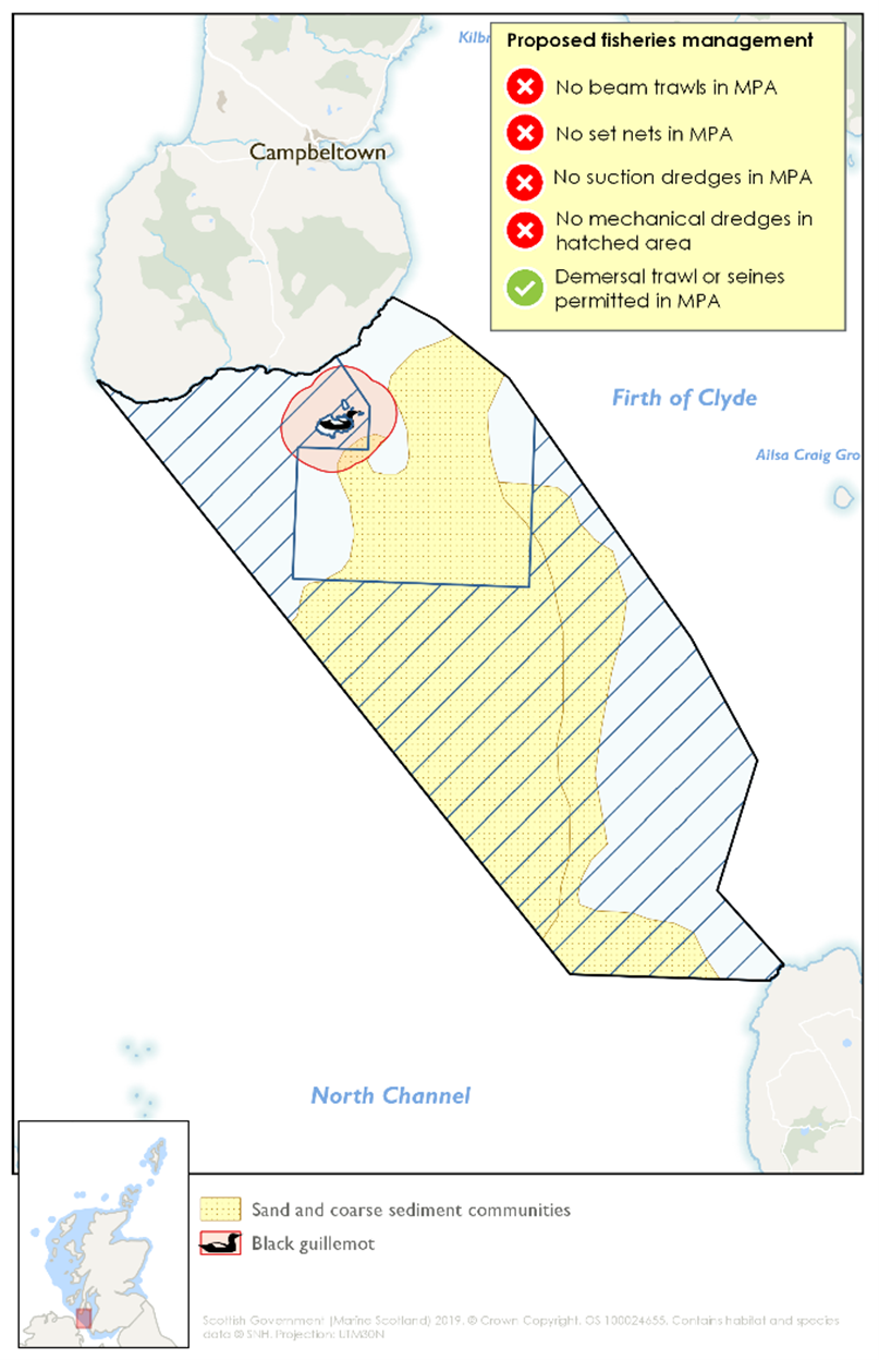
Figure 1. Original Marine Scotland (now Marine Directorate) management proposal for the Clyde Sea Sill MPA (2019).
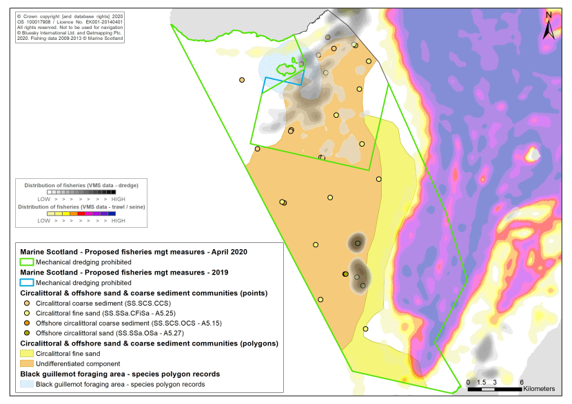
Figure 2. Map showing changes to proposed fisheries management measures in the Clyde Sea Sill MPA following initial stakeholder discussions.
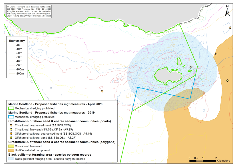
Figure 3. Map showing changes to proposed fisheries management measures in the Clyde Sea Sill MPA following initial stakeholder discussions.
In both Figures 2 and 3 the blue line is the previous draft fisheries management boundary (2019) and the green line shows the amended proposal (April 2020). Additional stakeholder discussions are envisaged in 2020/21 and these may result in further refinements.
Proportion of seabed habitat feature covered by the different management scenarios
The proportion of the seabed habitat protected feature encompassed by the original (2019) and revised (April 2020) management scenario is set out in Tables 2 and 3 below.
| Protected feature | Total area of habitat in MPA (ha) | 2019 Area within boundary (ha) | 2019 % of total habitat of MPA in management boundary | April 2020 Area within boundary (ha) | April 2020 % of total habitat of MPA in management boundary |
|---|---|---|---|---|---|
| Circalittoral and offshore sand and coarse sediment communities | 39358.3 | 28481.5 | 72.4 | 28423.4 | 72.2 |
| Protected feature | Total no. of habitat points in MPA | 2019 No. of points within boundary | 2019 % of total points of MPA in mgmt. boundary | April 2020 No. of points within boundary | April 2020 % of total points of MPA in mgmt. boundary |
|---|---|---|---|---|---|
| Circalittoral and offshore sand and coarse sediment communities (all points) | 29 | 15 | 51.7% | 15 | 51.7% |
| Circalittoral coarse sediment’ (SS.SCS.CCS) | 9 | 3 | 33.3% | 3 | 33.3% |
| Offshore circalittoral coarse sediment SS.SCS.OCS | 1 | 1 | 100% | 1 | 100% |
| Circalittoral fine sand SS.SSa.CFiSa | 18 | 10 | 55.6% | 10 | 55.6% |
| Offshore circalittoral sand SS.SSa.OSa | 1 | 1 | 100% | 1 | 100% |
Conclusions
Based on the habitat polygon data, an adequate proportion of the ‘Circalittoral and offshore sand and coarse sediment communities’ feature is encompassed within both the 2019 and 2020 Marine Scotland proposed fisheries management restrictions.
Whilst the polygon data is not broken down into the component biotopes of the broad MPA habitat, the point data provide an indication of the relative proportions of the components present in the site. It is important that these various components are protected within the management measures to ensure that the feature’s structure is conserved. The existing point data suggest that an adequate proportion of each of the component biotopes would be protected by both management proposals (ranging from 33.3% to 100%).
References
Envision Mapping Ltd. 2014. Predictive Mapping of MPA protected features within selected possible Nature Conservation MPAs in Scottish territorial waters using available datasets.