NatureScot Research Report 1327 - The creation of a Grassland Fungi Mapping Database for Scotland
Year of publication: 2024
Authors: Mitchel, D.G. & O’Brien, K.
Cite as: Mitchel, D.G. & O’Brien, K. 2024. The creation of a Grassland Fungi Mapping Database for Scotland. NatureScot Research Report 1327.
Contents
- Keywords
- Acknowledgements
- Abbreviations
- Summary
- Results
- Main findings
- Introduction
- Methods
- Results
- Discussion
- Project outputs
- References
- Annex 1. British grassland waxcap (Hygrocybe s.l.) with high diversity indicator species (after the guidelines for SSSI selection by Bosanquet et al. 2018)
- Annex 2. SSSI selection thresholds for grassland fungi (after Bosanquet et al. 2018)
- Annex 3. Clubs, spindles and corals (clavarioid fungi), as defined by Roberts (2015), alongside their current names (Legon & Henrici) (after Bosanquet et al. 2018)
- Annex 4. Earthtongue (geoglossoid fungi), as defined by Spooner (1998), alongside their current names
- Annex 5. IUCN Red List species (NT-CR) as of 28 Feb 2020
Keywords
Grassland fungi; waxcaps; Hygrocybe; fairy clubs; earth tongues; pink gills: Clavarioid fungi; Geoglossoid fungi; Entolomataceae
Acknowledgements
Thanks must go first and foremost to all the organisations and individuals that provided data for this project. Without them, it could not have happened. They are:
- The British Mycological Society and Stuart Skeates who extracted the data from the FRDBI
- Liz Holden who also helped with local site knowledge and comments on species of Entoloma to include
- Highland Biological Records Group and Murdo Macdonald
- Argyll Biological Records Centre
- Fife Nature Records Centre
- North East Scotland Biological Records Centre
- Grampian Fungus Group
- Fungus Group of South East Scotland
- Edinburgh and Lothian Fungus Enthusiasts
- Outer Hebrides Biological Recording Group
- RSPB who also provided GIS data for Abernethy Forest to help interpret this site
- Professor Roy Watling
- Nev Kilkenny
- Chris Knowles
- Matthew Rooney
- Alistair Hutchinson
- Isle of Eigg rangers
Abbreviations
Argyll Biological Records Centre (ABReC)
British Mycological Society (BMS)
Checklist of the Basidiomycetes of Ireland and Britain (CBIB)
Clavarioids, Hygrocybe, Entolomataceae, Geoglossoids, Dermoloma (CHEGD)
Edinburgh and Lothian Fungus Enthusiasts (ELFE)
Environmental DNA (eDNA)
Fife Nature Records Centre (FNRC)
The Fungal Records Database of Britain and Ireland (FRDBI)
Fungus Group of South East Scotland (FGSEC)
Geographical Information System (QGIS)
Global Biodiversity Information Facility (GBIF)
Highland Biological Records Group (HBRG)
Joint Nature Conservation Committee (JNCC)
National Biodiversity Network (NBN)
North East Biological Records Centre (NESBReC)
Quantum Geographical Information System (QGIS)
Royal Society for the Protection of Birds (RSPB)
Site of Special Scientific Interest (SSSI)
Taxon Version Key (TVK)
United Kingdom Species Inventory (UKSI)
Summary
Grasslands can be a very biologically rich habitat, and can have many species of conservation interest. There are several groups of grassland fungi, known collectively as CHEGD species, for which unimproved grasslands are essential. The fungal community in a grassland can take centuries to form and are vulnerable to land-use change. Due to the past management of land in the UK, the UK is of European importance for unimproved grassland, and traditional farming and maintenance of grassy areas continues to be of importance to grassland fungi species.
Pressures on grasslands that may lead to the loss and fragmentation of these diverse habitats. If we had a better knowledge of where the important sites for grassland fungi are, they could be conserved. Making the data easily accessible and easy to integrated into planning checks could allow grasslands of importance to be identified and protected.
This project aimed to use mycological records from a variety of record holders to create a database of sites that host important grassland fungi assemblages. For this, records were collected from record sources, ‘cleaned’ to ensure validity, preferred ‘sites’ allocated to logical groups of grid references, and CHEGD and SSSI scores calculated for each site. In order to increase the usability of the database, a set of GIS mapping layers have been made to allow the data to be visualised. These layers are available for download on the Scottish Government’s spatial data catalogue and can be used by both public and private sector organisations. There is also a simplified webpage version available for landowners without GIS skills to view their area.
Results
- 36,558 records of grassland fungi from 27 different data sources have been collated into the database. There are duplicate records in this dataset but as the analysis is made on summarised data, this is not an issue.
- 5,378 unique site names have been used in this record set and these have been grouped into 3,351 preferred site names to allow the site’s CHEGD and SSSI scores to be calculated.
Main findings
- The calculated CHEGD scores allowed the sites to be assessed against the JNCC guidelines for selecting SSSIs. 67 sites pass one or more of the SSSI thresholds. This has been translated into a mapping tool that allows the data to be visualised.
- Hopetoun House in West Lothian is the top site in Scotland for waxcaps with 29 species.
- Duackbridge by Nethy Bridge in East Inverness-shire is the top site for fairy clubs with 11 species.
- Morrone by Braemar is the top site for grassland Entolomataceae with 36 species.
- Muirshiel Country Park near Lochwinnoch in Renfrewshire is the top site for earth tongues with 8 species.
- No sites in Scotland pass the “D” threshold for Dermoloma and other genera.
Introduction
Grassland fungi can be found in a range of grassland types from dunes to uplands, from lowland hay meadows to churchyards. Indeed, some old gardens and churchyards that have been managed as grassland without the addition of fertilizers for decades to centuries have become the last refuge of grassland species that require continuity of habitat. Waxcap grasslands are not always botanically rich which can mean that they are often missed when choosing sites for nature conservation. Records are generally from fruit body (e.g. mushroom) surveys, and fruit bodies, which are only visible at certain times of the year, and may not fruit every year, which obscures presence further.
Species rich unimproved grasslands are rare and are threatened by agricultural intensification, decline of traditional grazing and hay production, and land abandonment. As well as these causing direct loss of suitable grassland, this can also cause fragmentation of habitats. More recently, woodland development projects have been transforming grasslands, and due to the difficulty of grassland fungi ID and limited fruiting season it is hard to make right tree right place judgements. Many species of grassland fungi are on the IUCN Global Red List in categories of Near Threatened, Endangered and Vulnerable, and many more are on national Red Lists across Europe. With the pressures upon them, a clear understanding of where Scottish sites of particularly high grassland fungi value are will allow land developers and Woodland developers to make more-informed considerations for nature.
The planning of land use change can be a significant undertaking. For woodland development schemes, projects often have conservation elements, and biodiversity considerations are sometimes required for tree planting grants. However, planning can be hindered by the cost, skill, and seasonal constraints around surveying for fungal diversity. Given the number of species that make up grassland fungi assemblages, a records based study would be a complex and time consuming exercise for an individual project to carry out, and yet information on sites of mycological importance across Scotland could be very useful in the early stages of planning.
Various scoring systems have been proposed across Europe to evaluate waxcap grasslands for conservation importance, but this has led to different species concepts and methodologies used for scoring sites, making it hard to compare sites. CHEGD scores have been incorporated into this project, and is a simple scoring system that quantifies the numbers of fairy clubs (Clavarioid fungi or C group), waxcap (Hygrocybe s.lat. or H group), pink gills (Entolomataceae or E group), earth tongues (Geoglossoid fungi or G group) and the smaller genera of the crazed caps and assoicates Dermoloma, Camarophyllopsis, Hodophilus and Pseudotricholoma (Porpoloma) – the D group. This database uses the CHEGD as a one-point-per-species scoring method. This database also incorporates the JNCC revised guidelines for SSSI site selection (Bosanquet et al 2018), a set of guidelines and definitions of taxa for inclusion which provides a clear consistent scoring method designed for making decisions around designation and whether land use change should be avoided. It should however be noted very few of the sites that pass the SSSI threshold will be designated, but may fall under other biodiversity protections. It is indicative that where possible, the site should continue to be managed for the fungi interest and avoided by development.
This project has been able to benefit from a system set up in Microsoft Access to analyse waxcap grassland data first in a grassland fungi database that covered Northern Ireland and Republic of Ireland in 2017, then to a database covering Wales in 2017 and to England in 2020. Hence the system did not have to be created for Scotland but could be re-used. This lends itself to future analysis at the larger scale of Britain and Ireland. The JNCC guidelines for non-lichenised fungi (Bosanquet et al, 2018) have been built into the analysis ensuring a consistent site analysis now across all of Britain and Ireland. A waxcap grassland survey of Scotland was performed in 2002 (Newton et al 2003), and while this database uses much of the data produced by the surveys, the technology that has allowed for addition of the mapping tools by this project increases the usefulness to the conservation of grassland fungi.
Methods
The exercise can be broken down into a number of steps:
- Data collation
- Data consolidation and cleaning
- Analysis
- Producing the outputs, including a mapping tool for the visualisation of data
Data collation
Kat O’Brien and David Mitchel contacted the Scottish biological records centres, Scottish local fungus groups, key individuals, and the British Mycological Society who manage the the Fungal Records Database of Britain and Ireland (FRDBI). Permission for record use was gained with the understanding that the records or derivatives will be freely available and will be used for conservation and to inform responsible development. Records were provided in a variety of formats mostly in Excel with some in Word. The latter needed to be transposed first into Excel before the next stage. Some key published records that have not been databased were also included. Due to internal capacity and protocol issues, some datasets have been identified but are still outstanding. The list of data sources is shown in Table 1.
Table 1. List of data sources
| Source | No Records |
|---|---|
| FRDBI Old 2023 | 13138 |
| FRDBI New 2023 | 10970 |
| Liz Holden records | 3965 |
| HBRG | 2319 |
| Argyll BRC | 1805 |
| David Mitchel data | 739 |
| GBIF: National Trust for Scotland | 614 |
| Fife Nature Records Centre | 598 |
| Nev Kilkenny | 494 |
| NESBReC Grampian Fungus Group | 482 |
| RSPB Data | 394 |
| NESBReC | 361 |
| GBIF: Outer Hebrides Biological Recording | 261 |
| SNH Database 2000 | 246 |
| Chris Knowles | 143 |
| Islay Fungi Records (Alistair Hutchinson) | 98 |
| Published Records: Checklist of the non-lichenised Fungi of Fair Isle (2021) | 87 |
| GBIF: Scottish Wildlife Trust | 75 |
| Matthew Rooney | 67 |
| Mycologica Scotica | 27 |
| FGSES | 26 |
| ELFE | 19 |
| Published Records: Additions to the Fungus Flora of the Hebrides (1983) | 17 |
| GBIF: Stichting Observation International | 12 |
| Gareth Griffith | 1 |
| GBIF: University of Oulu, Finland – Herbarium | 1 |
| Global Soil Organisms (eDNA) | 1 |
| Published Records: Studies in Entoloma (1984) | 1 |
All the records in this edition of the database are from fruiting body records, but the system can incorporate environmental DNA (eDNA) records as well. eDNA is a rapidly evolving field where all the DNA in soil samples is analysed and identified, and holds great potential for allowing grassland sites of importance to be identified all year round. However, there is only a single eDNA record in the Scottish system from a European wide soil survey included in this database, and the use of eDNA data is currently suffering from a lack of accessible data. When available, it is hoped this database can be updated to incorporate eDNA data. eDNA surveys on waxcap grasslands have been undertaken in England and Wales, and have identified a significant number of species as species that have never been found as fruiting bodies in the UK. This may be because there are cryptic overlooked species, but while the disjunction between above ground and below ground data is being looked into, Natural England and Natural Resources Wales have both requested that the site scoring for fruiting bodies and eDNA data is done separately. It can easily be combined at a later date.
Data consolidation and cleaning
All datasets provided were loaded into a holding database in Microsoft Access for checking and transposing into a standard format. Whilst the numbers of attributes for each dataset varied, the core required fields were:
- Species
- Date
- Grid reference in British National Grid or Latitude and Longitude, to a minimum of 4 figures
Any records without these attributes were rejected. Highly desirable fields were:
- Site name - some datasets withheld this so it had to be allocated based on the grid reference if it was sufficiently detailed. Low resolution grid references and no site name meant the record was rejected
- Recorder – some datasets withheld this
- Determiner – some datasets withheld this
- Watsonian Vice County that the recorder said they were in. This is a key part of the spatial check so it was requested
Date fields are often stored in different ways in different systems to be able to handle vague dates e.g., just a month or year. Some databases hold separate Day, Month and Year fields e.g., the old FRDBI and GBIF whilst others use the NBN format of a start date, end date and date type where type is Day, Month, Year or a range of either. This database holds both types, takes what is provided and transposes into the other system.
As done in the bolete GB Red List (Ainsworth et al 2013) and the Non-lichenised fungi SSSI guidelines (Bosanquet et al 2018), any records more than 50 years old are excluded from site assessments as the habitat may have changed since older records were taken. These pre-1973 records were removed prior to the import to avoid wasted effort linking them to preferred sites and checking their grid references.
The database contains a species table in which every published name for a CHEGD species is included. The species table is fully compatible with the BMS Checklist, which feeds the UK Species Inventory (UKSI) (or will be when the NBN Species Dictionary is fully updated). All entries have an NBN Taxon Version Key and if a different code is used, this is because the name has yet to be given a TVK by the UKSI. This Species table stores the preferred name for that TVK and its SSSI scoring name according to the JNCC guidelines along with the CHEGD type. To be included in this database, all typing errors in the given species names in the collated datasets were identified and corrected.
Before importing into the database, all records were loaded into QGIS and checked spatially to filter out misreported grid refs that weren’t in Scotland, were in the sea or weren’t in the vice county that they said they were in. The sources of error were usually predictable in that either the wrong grid letter was used or the easting and northing was reversed. In the case of less obvious errors, the record provider was contacted for clarification, but in some cases other clues like where that recorder had been elsewhere on that day or on recent dates were used. However, it must be noted that not all grid reference errors can be fixed or even spotted. Errors within the reported vice county are more difficult and often it was due to randomly noticing errors that fixes were made.
The largest data source was the FRDBI, which is in a state of flux. The “old” FRDBI database has now been retired and the data is in the process of being moved over to the “new” FRDBI which is based on iRecord and powered by Indicia. Records are in the process of being moved over to the new FRDBI but this is far from complete mainly due to data issues. The old FRDBI had few data validation routines and many fields were free text meaning all sorts of varieties of information was put into fields. Exports from both databases were obtained. Those records on the new FRDBI were virtually all clean but those on the old FRDBI needed considerable cleaning and checking. Records in the new FRDBI store the old FRDBI number so duplicates were removed.
The records that were downloaded from GBIF needed one extra stage of processing as all site names were withheld for these records. As this is a key attribute, to be able to incorporate these records, a site name had to be assigned to these records. The process for doing this was:
- Convert the lat/longs provided to British National Grid using the Ordnance Survey GridInQuest II software programme taking into account the stated resolution of the record.
- Querying the existing Records table to see if there were existing records with the same grid reference and if so, using that site name
- If there were no matches, using QGIS check if there were nearby records with a site name
- If there were no nearby records, assign a site name from the OS map. There is an obvious risk of error here but it was judged that was better than ignoring the record which had a spatial location albeit sometimes generalised.
Once the records passed this stage of consolidation and cleaning, they were imported into the Scottish Grassland Fungi Database.
Scottish Grassland Fungi Mapping Database structure
The database structure is identical to the Republic of Ireland/Northern Irish, Welsh and English grassland fungi databases and benefits from any new functionality or improvements made in those projects being applied to this database moving forward as well. The added benefit is that data can easily be merged and analysed at a wider scale which is particularly useful in setting the context for the Scottish data and also when looking at aspects like indicator species.
A Microsoft Access database is used to run the analysis and produce the different outputs in Excel, GIS and html hence the database is not actually needed to work with the outputs if Access is not available. The interface is written so Access skills are not required to run the different queries and outputs. NatureScot has received the Excel and GIS layers. This does however make it harder to update the database on a regular basis due to the disconnection between levels of the database and the mapping tool.
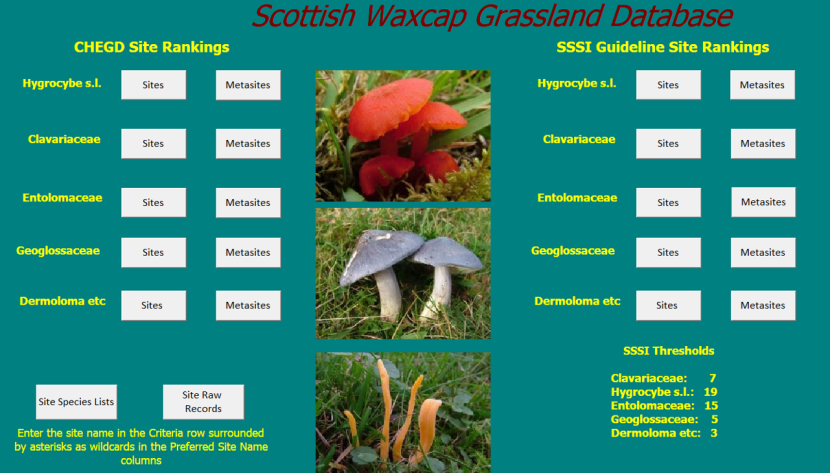
Figure 1. Scottish Grassland Fungi Database Front End Main Screen
Click for a full description
The main interface for the Scottish Grassland Fungi Database. It shows buttons for the sites and metasites for each of the CHEGD groups. There is a column of buttons for CHEGD site rankings and a column for SSSI site Rankings. There are also buttons for site species lists and site raw records.
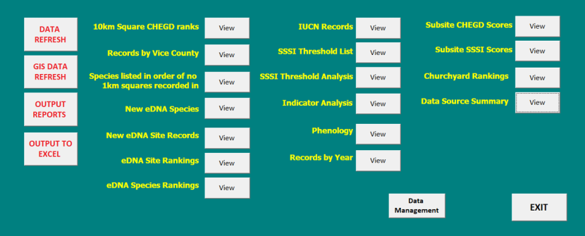
Figure 2. Scottish Grassland Fungi Database Front End - Other Functions
Click for a full description
Screenshot of the key database tools showing the other queries and functions that can be run from the database Scottish Grassland Fungi Database front end.
Figure 3 shows the key database tables and how they are related.
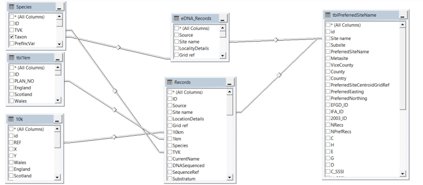
Figure 3. Scottish Grassland Fungi Database Schema
Click for a full description
Diagram showing key database tables and relationships between the tables. The 6 key database tables are Species, 1km, 10k, eDNA records, Records, and Preferred site name.
Preferred site name, metasites and subsites
Once new records were imported into the database, they were assigned a Preferred Site Name, allowing a concept of a ‘site’ to be created that could then be scored by the records within the area. With 5,547 unique site names and 3,450 preferred site names in the Scottish database, assigning a site name to a Preferred Site Name was the single largest task in this project. In addition, some recorders have been very precise in their recording giving detailed subsite names and this has been retained where possible with the site name being given a subsite and a Preferred Site Name. Many sites have also been assigned to the larger concept of Metasite; this is a handy tool to find out the CHEGD score and species recorded on larger concepts like islands or large glens.
If a record had a 6 figure grid reference or better and a Preferred Site Name had records with the same grid reference, the new site name was given the Preferred Site Name automatically. All other new site names were checked manually in GIS looking for nearby records with an existing Preferred Site Name.
Preferred Site Names were allocated using some standard rules:
- Following FRDBI protocols, the wider site name comes first following by names for more detail, e.g. “Cairnbeg Road, Cove, Aberdeen” would become “Aberdeen: Cove: Cairnbeg Road”. This allows adjacent sites to be easily grouped in lists and reports.
- Any site with “St” in the name, e.g. a churchyard, was given a full stop after the “St” so preventing two names for a churchyard being grouped as two different sites.
- Abbreviations are avoided in the site name as these were inconsistently applied e.g. “ch’yd”, “NR”, “CP”. Statutory designations like “NNR” and “SSSI” were not changed.
- House names and numbers were renamed to a street name or area name to remove personal data.
All sites that were churchyards or graveyards were also tagged allowing a query to be run later ranking churchyard sites across Scotland, as churchyards are known to be significant sites for grassland fungi, but are often overlooked by conservation efforts due to their anthropogenic nature.
Assigning preferred site names via a desk exercise is not simple: many intermingled site names have been used by different recorders that it is sometimes difficult to work out what is the actual “site”. Liz Holden, a Scottish mycological expert, provided some very useful local knowledge with some of the most complicated sites and the RSPB helped providing detailed GIS compartment boundaries for Abernethy Forest which allowed records to be assigned to these large compartment units.
On larger site or metasites, some records were given the general area name and a two figure grid reference e.g. “South Ronaldsay”. In this situation, it is impossible to know where on South Ronaldsay the records were from so it was assigned the Preferred Site Name of “South Ronaldsay (unlocalised)”.
Second stage spatial check
Once all sites were assigned a Preferred Site Name, a centroid was calculated for that Preferred Site based on all the grid references for that site. This was calculated via Access queries with higher resolution records being given a weighting so reducing the effect of 10km grid references “pulling” the centroid grid reference away from the main cluster of records, rather than using the QGIS tool ‘Mean coordinates’, which gave some unusual results.
The QGIS Connect Points plugin was then used to measure the distance of each record from the site centroid. If the record was a large distance e.g. 8km or more away from the centroid, it was down to either a bad grid reference or two locations with a similar name having been linked together incorrectly. Both scenarios were fixed if required.
Without doubt, the Preferred Site Names could be improved with local knowledge. In particular, sites with less than 10 species of waxcap were not examined in such detail due to time constraints. The sites and subsites have centroids but no firm boundaries, and may incorporate pieces of unsuitable habitat such as housing or woodland that are unsuitable for grassland fungi. Therefore, some level of human sense checking and comparison with maps are necessary.
Taxonomic issues
Missing defined scoring species
The revised JNCC guidelines (Bosanquet et al., 2018) listed the scoring taxa of waxcaps (H), fairy clubs (C) and earth tongues (G) and these are shown in Annexes 1, 3 and 4 respectively. However, the pink gills (E) and the Dermoloma group (D) were not defined. These two groups are undergoing considerable taxonomic change so defining the scoring species of these groups should a priority in any revision of the guidelines. Members of both of these groups are found in other habitats than grasslands so for scoring grassland sites, these need to be excluded otherwise a site with a pocket of woodland can score artificially highly confusing the analysis. The process used here for selecting which pink gills to include has been;
- Exclude species in which grassland is not mentioned as a habitat preference in the Kew Checklist of the Basidiomycetes of Britain and Ireland
- Double check the excluded species habitat preference in the Fungi Europaei volumes on Entoloma
- Review the retained species with Liz Holden
Taxonomy will continue to be reviewed when the database undergoes updates, and the same changes will be made across the Northern Irish/Republic of Ireland, Welsh and English databases when they are updated to keep all up to date and intercompatible.
Species aggregates
Another difficulty when scoring grassland fungi sites is how to deal with species that have been split into two or more species. The revised JNCC guidelines tackled this by only scoring the species aggregate. For example, the green earth tongue, Microglossum olivaceum, has been split into a number of species and it is actually unclear if M. olivaceum even exists itself. So, the scoring taxa for grassland fungi sites for SSSI assessment is M. olivaceum agg. Due to ongoing DNA analysis, this is happening a lot and there are a number more aggregates now e.g. Entoloma bloxamii, Entoloma longistriatum (which is now known to be an American species with records being probably one of two European species), Entoloma rhombisporum and Hodophilus hymenocephalus (which is now also known to be an American species with existing European records likely to be H. stramineus).
For SSSI scoring, the aggregate scoring is simple and works well but it is predicted that, new taxonomy and eDNA identified records may be used a future edition. Hence the database calculates both the SSSI score and the full CHEGD score.
However, care is needed when scoring the full CHEGD score as if say there is a record of both Microglossum olivaceum s. lat. and one of the new names e.g. Microglossum tenebrosum on a site, the two names should not count towards the G score as they may actually have been of the same species. They may have been different but the safer presumption is that they were the same. So, the database calculates if a sensu lato name and one of the new constituent species are recorded on the site, only the constituent species will count to scoring.
New cryptic species
Since the JNCC guidelines were published, a set of new grassland fungi species have been accepted as being in Britain. These are included in the Species table in this database, but have been linked to the existing SSSI scoring name. The new species added are listed in Table 2.
Table 2. New cryptic species accepted in the UK and their SSSI scoring name
| Species | Authors | SSSI Name | Type |
|---|---|---|---|
| Clavaria tyrrhenica | Franchi & M. Marchetti | Clavaria incarnata | C |
| Cuphophyllus atlanticus | J.B. Jordal & E. Larss. | Hygrocybe canescens | H |
| Dermoloma alexandri | Consiglio | Dermoloma cuneifolium | D |
| Dermoloma bellerianum | Bon | Dermoloma cuneifolium | D |
| Glutinoglossum pseudoglutinosum | V. Kučera | Glutinoglossum glutinosum | G |
| Hodophilus anatinus | Dima, Adamčík & Jančovič. | Hodophilus micaceus | D |
| Hodophilus stramineus | Jančovič., Dima & Adamčík | Hodophilus hymenocephalus s.lat. | D |
| Hodophilus subfoetens | Adamčík, Jančovič. & Looney | Hodophilus foetens | D |
| Hodophilus tenuicystidiatus | Jančovič., Adamčík & Looney | Hodophilus foetens | D |
| Hodophilus variabilipes | Jančovič., Adamčík & Looney | Hodophilus atropunctus | D |
| Hygrocybe monteverdae | Bañares & Arnolds | Cuphophyllus pratensis var. pallidus | H |
| Microglossum rufescens | (Grelet) Bon | Microglossum olivaceum | G |
| Ramariopsis asperulospora | (G.F. Atk.) Corner | Clavaria asperulispora | C |
| Ramariopsis pseudosubtilis | R.H. Petersen | Ramariopsis subtilis | C |
| Ramariopsis robusta | Matouš & Holec | Ramariopsis kunzei | C |
Results
Data overview
It is felt that the vast majority of quality grassland fungi records for Scotland are included in this database. All key mycological recorders, recording groups and local records centres and the British Mycological Society were contacted. The only two known gaps in the data are the Glasgow Museums Biological Records Centre who could not supply data due to staffing issues and The Wildlife Information Centre.
In terms of the spatial distribution of the records, figures 4 and 5 show the location of all CHEGD records and map of 10km squares coloured according to the number of Waxcaps in that square. From these two maps, it can be seen that there is a noticeable cluster of good sites around Braemar and Nethybridge. Shetland, the north coast and Lismore are other notable hot spots. While these hotspots can reflect recording effort, they will be very good areas in themselves.
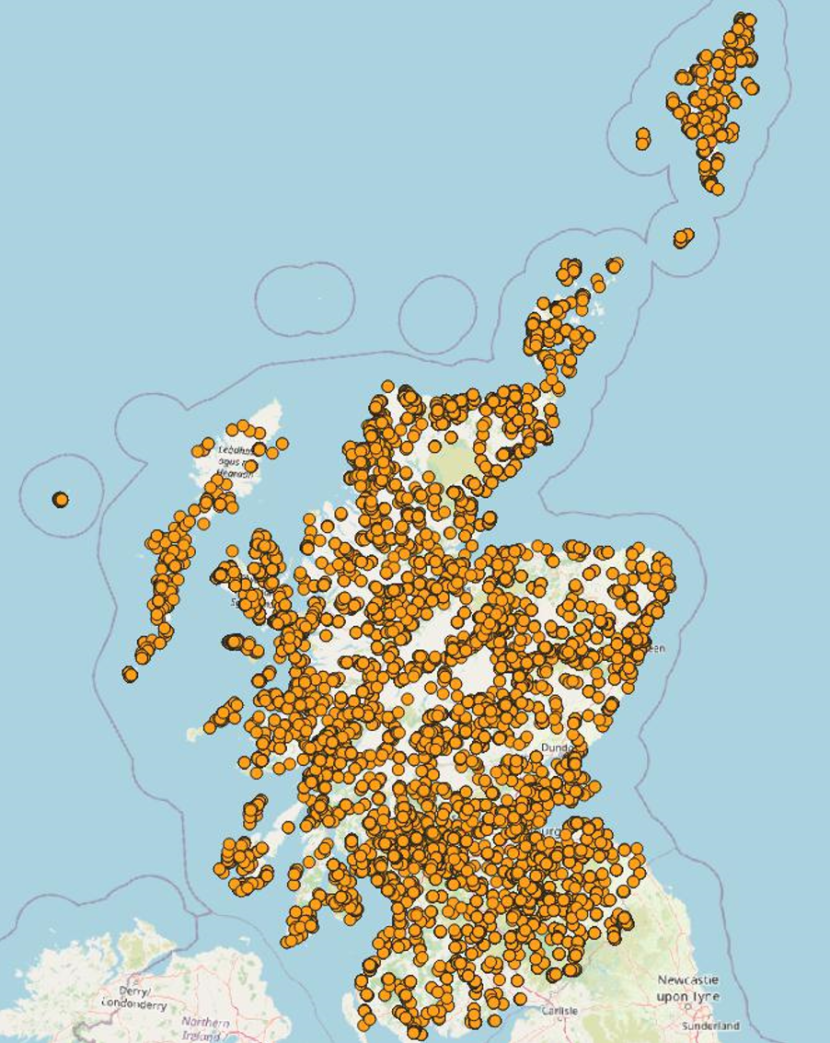
Figure 4. Map of Grassland Fungi Records for Scotland
Click for a full description
Map of Grassland Fungi Records for Scotland. Sites are marked by orange circles, and are spread across the whole of Scotland.
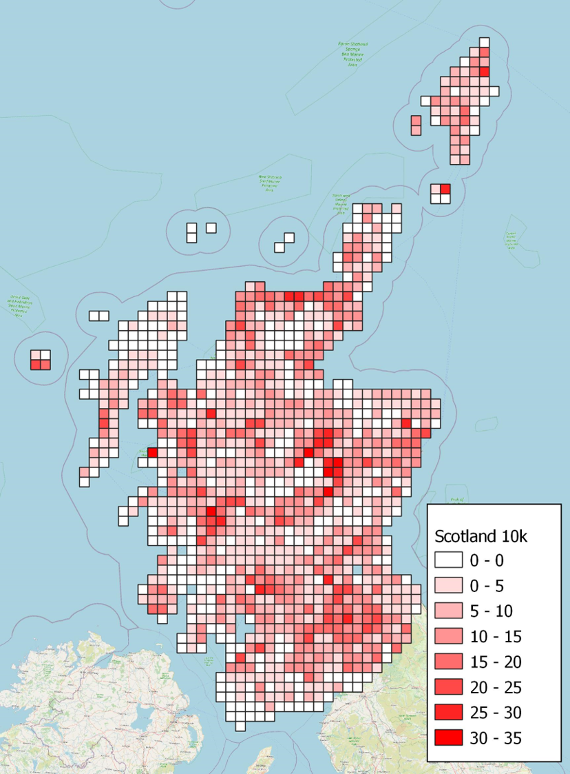
Figure 5. Map of 10km squares showing numbers of Hygrocybe s.lat. species
Click for a full description
Map of 10km squares showing numbers of Hygrocybe s.lat. species in squares in a gradient of reds. The darkest shade represents 30-35 species per 10km.
There are also noticeable blank areas with Lewis, Tiree, Jura and the South West likely to be much better areas than they appear, but may be under recorded. Other areas like central Sutherland are probably genuinely of lesser interest due to the large areas of bog.
Site rankings
The database allows the sites to be ranked by full CHEGD scores or SSSI scores. There is only usually only a small difference between the two systems either because the montane species (Chromosera spp, H. salicis-herbaceae) or the dune species (H. conicoides or H.olivaceonigra) are not included in the SSSI scoring system and also due to the aggregate issues as discussed above.
The SSSI and CHEGD scores confirm Scotland as one of the key areas in Western Europe for waxcap grasslands. For comparison, in the Netherlands the best site has 24 waxcaps, and only two sites score over 20 species (Arnolds, 2015), while the best site in Scotland (Hopetoun House) has 29 waxcap species and there are 36 sites that score 20 or more waxcap species.
Table 3 shows all the top sites for Hygrocybe s. lat. that pass the SSSI threshold score of 19 species. The number of each species in each category of CHEGD species are shown for the site. These are marked by the red dots in Figure 4. 47 sites pass this threshold.
Table 3. Grassland Fungi sites ranked by SSSI scoring species of Waxcap (Hygrocybe s. lat.)
| Site | Vice County | Centroid | C | H | E | G | D | No Visits | Last Visit |
|---|---|---|---|---|---|---|---|---|---|
| Hopetoun House | West Lothian | NT090790 | 9 | 29 | 6 | 1 | 1 | 16 | 24/08/2022 |
| Canna | North Ebudes | NG250052 | 8 | 28 | 27 | 5 | 1 | 53 | 18/08/2022 |
| Kindrogan Field Centre and surrounds | East Perthshire | NO054626 | 8 | 28 | 26 | 4 | 1 | 54 | 26/08/2017 |
| Haddo House & Country Park | North Aberdeenshire | NJ868347 | 10 | 27 | 16 | 2 | 1 | 33 | 23/10/2022 |
| Lochwinnoch: Muirshiel Country Park | Renfrewshire | NS310632 | 7 | 27 | 9 | 8 | 1 | 17 | 25/10/2020 |
| Braemar: Glen Lui flats | South Aberdeenshire | NO049928 | 9 | 26 | 20 | 7 | 1 | 22 | 16/10/2012 |
| Braemar: Inverey Flats | South Aberdeenshire | NO093895 | 9 | 26 | 20 | 2 | 1 | 24 | 15/09/2008 |
| Fair Isle | Shetland | HZ215721 | 7 | 26 | 27 | 7 | 0 | 52 | 28/09/2020 |
| St. Kilda: Hirta | Outer Hebrides | NF097994 | 7 | 26 | 21 | 6 | 0 | 24 | 01/08/2004 |
| Braemar: Morrone | South Aberdeenshire | NO137904 | 4 | 26 | 35 | 4 | 1 | 44 | 24/09/2022 |
| Rassal | West Ross | NG841430 | 0 | 26 | 4 | 0 | 1 | 2 | 24/10/2000 |
| Kincraig: Dunachton east | East Inverness-shire & Nairn | NH834054 | 4 | 25 | 4 | 1 | 1 | 16 | 21/10/2017 |
| Peebles: Tantah | Peebleshire | NT245385 | 1 | 24 | 17 | 4 | 1 | 16 | 12/10/2000 |
| Abernethy Forest RSPB Reserve: Rynettin (compartments 25 & 95) | East Inverness-shire & Nairn | NJ013146 | 8 | 23 | 21 | 0 | 0 | 43 | 15/11/2022 |
| Skye: Trotternish: The Storr | North Ebudes | NG501533 | 6 | 23 | 5 | 4 | 1 | 4 | 19/10/2011 |
| Hill of Tarvit | Fifeshire | NO377116 | 9 | 22 | 9 | 6 | 1 | 14 | 15/11/2014 |
| Glen Strathfarrar: Deanie Lodge area / Loch Beannacharan | East Inverness-shire & Nairn | NH316394 | 6 | 22 | 16 | 4 | 1 | 17 | 16/09/2022 |
| Forvie NNR | North Aberdeenshire | NK030259 | 5 | 22 | 10 | 4 | 0 | 38 | 11/09/2022 |
| Torrisdale Dunes / Drum Chuibhe / Invernaver | West Sutherland | NC693611 | 4 | 22 | 18 | 4 | 0 | 23 | 23/07/2020 |
| Dunnet: Greenland Links / Dunnet Links / Dunnet Beach | Caithness | ND225695 | 3 | 22 | 20 | 4 | 0 | 41 | 31/10/2022 |
| Wanlockhead: Mennock Pass | Dumfriesshire | NS851102 | 2 | 22 | 7 | 4 | 1 | 4 | 21/10/2012 |
| Lendalfoot: Pinbain Hill | Ayrshire | NX143915 | 6 | 21 | 16 | 5 | 1 | 4 | 13/10/2012 |
| Lismore: Port Ramsay | Argyll | NM885456 | 6 | 21 | 2 | 2 | 0 | 12 | 15/10/2020 |
| Skye: Sleat: Bharabhaig | North Ebudes | NG686101 | 4 | 21 | 18 | 4 | 1 | 2 | 16/10/2001 |
| Dunbeath Strath | Caithness | ND141313 | 4 | 21 | 17 | 2 | 1 | 21 | 12/08/2022 |
| Selkirk: Whitmuir Estate | Roxburghshire | NT493264 | 9 | 20 | 11 | 6 | 1 | 21 | 08/10/2020 |
| Lauder Common | Midlothian / Berwickshire | NT484455 | 8 | 20 | 3 | 2 | 1 | 4 | 19/10/2019 |
| Lauder Fire Station: Hillside West of | Berwickshire | NT515485 | 6 | 20 | 1 | 0 | 0 | 2 | 07/10/2007 |
| Holms Water Valley | Peebleshire | NT088313 | 5 | 20 | 14 | 3 | 1 | 5 | 02/10/2000 |
| Braemar: Inverey Woods | South Aberdeenshire | NO077896 | 5 | 20 | 11 | 2 | 2 | 75 | 25/09/2022 |
| Carrifran | Dumfriesshire | NT155118 | 4 | 20 | 21 | 0 | 1 | 5 | 29/09/2000 |
| Braemar: Quoich Lower | South Aberdeenshire | NO115912 | 4 | 20 | 13 | 4 | 1 | 50 | 23/10/2014 |
| Lismore: Baleveolan | Argyll | NM845422 | 4 | 20 | 2 | 0 | 0 | 2 | 15/10/2019 |
| Lismore: Miller's Port - Port Balnure - An Dun | Argyll | NM814376 | 4 | 20 | 1 | 0 | 0 | 2 | 17/11/2021 |
| Craigmead Meadows SSSI | Fifeshire | NO234057 | 3 | 20 | 3 | 0 | 0 | 16 | 07/11/2002 |
| Glen Elchaig | West Ross | NH026293 | 1 | 20 | 7 | 2 | 0 | 5 | 28/09/2022 |
| Nethy Bridge: Duackbridge | East Inverness-shire / Moray | NH995203 | 11 | 19 | 6 | 1 | 0 | 48 | 23/10/2022 |
| Tweedale: Posso | Peebleshire | NT204325 | 7 | 19 | 12 | 5 | 1 | 3 | 07/10/2000 |
| Lismore: Baileouchdarach | Argyll | NM871437 | 5 | 19 | 2 | 0 | 0 | 5 | 10/11/2021 |
| Glen Clunie | South Aberdeenshire | NO148858 | 4 | 19 | 8 | 3 | 0 | 3 | 29/09/2012 |
| Selkirk: Selkirk Common | Selkirkshire | NT487274 | 3 | 19 | 4 | 0 | 0 | 7 | 17/09/2012 |
| Crosskirk to Ushat Head | Caithness | ND031702 | 2 | 19 | 13 | 1 | 1 | 15 | 10/08/2021 |
| Straloch | East Perthshire | NO040635 | 2 | 19 | 12 | 0 | 0 | 18 | 16/09/2010 |
| Durness: Balnakeil | West Sutherland | NC381674 | 2 | 19 | 4 | 2 | 0 | 14 | 17/10/2020 |
| Crossdykes Knowe | Dumfriesshire | NY257895 | 2 | 19 | 1 | 6 | 1 | 1 | 22/10/2000 |
| Glencoe: Loch Achtriochtan | Argyll | NN137564 | 2 | 19 | 1 | 1 | 1 | 2 | 02/11/2016 |
| Alemoor: Bellendean Rig | Selkirkshire | NT367156 | 0 | 19 | 12 | 0 | 0 | 3 | 10/10/2017 |
Table 4 shows all the top sites for Fairy Clubs or Clavarioids that pass the SSSI threshold score of 7 species. The number of each species in each category of CHEGD species are shown for the site. These are marked by the red dots in Figure 4. 20 sites pass the C threshold with Duackbridge at Nethy Bridge being the best site with 11 Fairy Clubs.
Table 4. Grassland Fungi sites ranked by SSSI scoring species of Fairy Club (Clavarioid fungi)
| Site | Vice County | Centroid | C | H | E | G | D | No Visits | Last Visit |
|---|---|---|---|---|---|---|---|---|---|
| Nethy Bridge: Duackbridge | East Inverness-shire / Moray | NH995203 | 11 | 19 | 6 | 1 | 0 | 48 | 23/10/2022 |
| Haddo House & Country Park | North Aberdeenshire | NJ868347 | 10 | 27 | 16 | 2 | 1 | 33 | 23/10/2022 |
| Hamilton: Chatelherault Country Park | Lanarkshire | NS735535 | 10 | 6 | 2 | 0 | 0 | 16 | 20/10/2018 |
| Hopetoun House | West Lothian | NT090790 | 9 | 29 | 6 | 1 | 1 | 16 | 24/08/2022 |
| Braemar: Glen Lui flats | South Aberdeenshire | NO049928 | 9 | 26 | 20 | 7 | 1 | 22 | 16/10/2012 |
| Braemar: Inverey Flats | South Aberdeenshire | NO093895 | 9 | 26 | 20 | 2 | 1 | 24 | 15/09/2008 |
| Hill of Tarvit | Fifeshire | NO377116 | 9 | 22 | 9 | 6 | 1 | 14 | 15/11/2014 |
| Selkirk: Whitmuir Estate | Roxburghshire | NT493264 | 9 | 20 | 11 | 6 | 1 | 21 | 08/10/2020 |
| Canna | North Ebudes | NG250052 | 8 | 28 | 27 | 5 | 1 | 53 | 18/08/2022 |
| Kindrogan Field Centre and surrounds | East Perthshire | NO054626 | 8 | 28 | 26 | 4 | 1 | 54 | 26/08/2017 |
| Abernethy Forest RSPB Reserve: Rynettin (compartments 25 & 95) | East Inverness-shire & Nairn | NJ013146 | 8 | 23 | 21 | 0 | 0 | 43 | 15/11/2022 |
| Lauder Common | Midlothian / Berwickshire | NT484455 | 8 | 20 | 3 | 2 | 1 | 4 | 19/10/2019 |
| Balloch Castle Country Park | Dunbartonshire | NS386829 | 8 | 10 | 1 | 2 | 0 | 6 | 18/09/2011 |
| Lochwinnoch: Muirshiel Country Park | Renfrewshire | NS310632 | 7 | 27 | 9 | 8 | 1 | 17 | 25/10/2020 |
| Fair Isle | Shetland | HZ215721 | 7 | 26 | 27 | 7 | 0 | 52 | 28/09/2020 |
| St. Kilda: Hirta | Outer Hebrides | NF097994 | 7 | 26 | 21 | 6 | 0 | 24 | 01/08/2004 |
| Tweedale: Posso | Peebleshire | NT204325 | 7 | 19 | 12 | 5 | 1 | 3 | 07/10/2000 |
| Lismore: Achinduin | Argyll | NM814395 | 7 | 18 | 1 | 3 | 0 | 2 | 02/11/2015 |
| Dawyck Royal Botanic Gardens | Peebleshire | NT161352 | 7 | 11 | 11 | 2 | 0 | 71 | 02/10/2022 |
| Larkhall: Millheugh Bridge | Lanarkshire | NS755505 | 7 | 2 | 1 | 2 | 2 | 1 | 18/09/1994 |
Table 5 shows all the top sites for Pink Gills or Entolomataceae that pass the SSSI threshold score of 15 species. The number of each species in each category of CHEGD species are shown for the site. These are marked by the red dots in Figure 4. 27 sites pass the E threshold with Braemar: Morrone being the best site with 35 Pink Gills which is also the second best site in the British Isles.
Table 5. Grassland Fungi sites ranked by SSSI scoring species of Pink Gills (Entolomataceae)
| Site | Vice County | Centroid | C | H | E | G | D | No Visits | Last Visit |
|---|---|---|---|---|---|---|---|---|---|
| Braemar: Morrone | South Aberdeenshire | NO137904 | 4 | 26 | 35 | 4 | 1 | 44 | 24/09/2022 |
| Canna | North Ebudes | NG250052 | 8 | 28 | 27 | 5 | 1 | 53 | 18/08/2022 |
| Fair Isle | Shetland | HZ215721 | 7 | 26 | 27 | 7 | 0 | 52 | 28/09/2020 |
| Kindrogan Field Centre and surrounds | East Perthshire | NO054626 | 8 | 28 | 26 | 4 | 1 | 54 | 26/08/2017 |
| Mull: Ardmeanach: Burg | Mid Ebudes | NM421271 | 4 | 17 | 23 | 0 | 1 | 2 | 16/09/2012 |
| St. Kilda: Hirta | Outer Hebrides | NF097994 | 7 | 26 | 21 | 6 | 0 | 24 | 01/08/2004 |
| Abernethy Forest RSPB Reserve: Rynettin (compartments 25 & 95) | East Inverness-shire & Nairn | NJ013146 | 8 | 23 | 21 | 0 | 0 | 43 | 15/11/2022 |
| Carrifran | Dumfriesshire | NT155118 | 4 | 20 | 21 | 0 | 1 | 5 | 29/09/2000 |
| Glen Nevis | West Inverness-shire | NN133720 | 0 | 6 | 21 | 2 | 0 | 8 | 01/09/2018 |
| Braemar: Glen Lui flats | South Aberdeenshire | NO049928 | 9 | 26 | 20 | 7 | 1 | 22 | 16/10/2012 |
| Braemar: Inverey Flats | South Aberdeenshire | NO093895 | 9 | 26 | 20 | 2 | 1 | 24 | 15/09/2008 |
| Dunnet: Greenland Links / Dunnet Links / Dunnet Beach | Caithness | ND225695 | 3 | 22 | 20 | 4 | 0 | 41 | 31/10/2022 |
| Torrisdale Dunes / Drum Chuibhe / Invernaver | West Sutherland | NC693611 | 4 | 22 | 18 | 4 | 0 | 23 | 23/07/2020 |
| Skye: Sleat: Bharabhaig | North Ebudes | NG686101 | 4 | 21 | 18 | 4 | 1 | 2 | 16/10/2001 |
| Peebles: Tantah | Peebleshire | NT245385 | 1 | 24 | 17 | 4 | 1 | 16 | 12/10/2000 |
| Dunbeath Strath | Caithness | ND141313 | 4 | 21 | 17 | 2 | 1 | 21 | 12/08/2022 |
| Commonside Moor: Philhope | Selkirkshire | NT388091 | 0 | 3 | 17 | 0 | 0 | 1 | 02/09/2000 |
| Haddo House & Country Park | North Aberdeenshire | NJ868347 | 10 | 27 | 16 | 2 | 1 | 33 | 23/10/2022 |
| Glen Strathfarrar: Deanie Lodge area / Loch Beannacharan | East Inverness-shire & Nairn | NH316394 | 6 | 22 | 16 | 4 | 1 | 17 | 16/09/2022 |
| Lendalfoot: Pinbain Hill | Ayrshire | NX143915 | 6 | 21 | 16 | 5 | 1 | 4 | 13/10/2012 |
| Calvine: Struan Birchwood | Mid Perthshire | NN795655 | 2 | 18 | 16 | 0 | 0 | 7 | 01/09/1988 |
| Skye: Dunvegan coral beach | North Ebudes | NG225544 | 4 | 14 | 16 | 2 | 2 | 5 | 02/11/2020 |
| Kincraig: Highland Wildlife Park | East Inverness-shire & Nairn | NH804035 | 3 | 14 | 16 | 0 | 0 | 2 | 01/10/2022 |
| Black Wood of Rannoch | Mid Perthshire | NN576563 | 3 | 17 | 15 | 3 | 0 | 37 | 03/09/2016 |
| Balnaguard | Mid Perthshire | NN943525 | 1 | 11 | 15 | 0 | 1 | 5 | 15/09/1981 |
| Mingulay | Outer Hebrides | NL561835 | 0 | 9 | 15 | 0 | 0 | 6 | 17/08/1983 |
| Schiehallion: Roadside on north side of mountain | Mid Perthshire | NN731565 | 0 | 2 | 15 | 0 | 0 | 1 | 25/08/2000 |
Table 6 shows all the top sites for Earth Tongues or Geoglossaceae that pass the SSSI threshold score of 5 species. The number of each species in each category of CHEGD species are shown for the site. These are the red dots in Figure 4. 16 sites pass the G threshold with Lochwinnoch: Muirshiel Country Park being the best site with 8 Earth Tongues which is also the joint second best site in the British Isles.
Table 6. Grassland Fungi sites ranked by SSSI scoring species of Earth Tongues (Geoglossoid fungi)
| Site | Vice County | Centroid | C | H | E | G | D | No Visits | Last Visit |
|---|---|---|---|---|---|---|---|---|---|
| Lochwinnoch: Muirshiel Country Park | Renfrewshire | NS310632 | 7 | 27 | 9 | 8 | 1 | 17 | 25/10/2020 |
| Braemar: Glen Lui flats | South Aberdeenshire | NO049928 | 9 | 26 | 20 | 7 | 1 | 22 | 16/10/2012 |
| Fair Isle | Shetland | HZ215721 | 7 | 26 | 27 | 7 | 0 | 52 | 28/09/2020 |
| Crossdykes Knowe | Dumfriesshire | NY257895 | 2 | 19 | 1 | 6 | 1 | 1 | 22/10/2000 |
| Hill of Tarvit | Fifeshire | NO377116 | 9 | 22 | 9 | 6 | 1 | 14 | 15/11/2014 |
| Schiehallion | Mid Perthshire | NN716573 | 1 | 11 | 2 | 6 | 0 | 2 | 26/10/2000 |
| Selkirk: Whitmuir Estate | Roxburghshire | NT493264 | 9 | 20 | 11 | 6 | 1 | 21 | 08/10/2020 |
| Skye: Trotternish: Quiraing | North Ebudes | NG447684 | 3 | 14 | 3 | 6 | 0 | 3 | 21/12/2021 |
| St. Kilda: Hirta | Outer Hebrides | NF097994 | 7 | 26 | 21 | 6 | 0 | 24 | 01/08/2004 |
| Canna | North Ebudes | NG250052 | 8 | 28 | 27 | 5 | 1 | 53 | 18/08/2022 |
| Lendalfoot: Pinbain Hill | Ayrshire | NX143915 | 6 | 21 | 16 | 5 | 1 | 4 | 13/10/2012 |
| Megget | Peebleshire | NT155205 | 4 | 15 | 4 | 5 | 0 | 2 | 01/10/2000 |
| Skye: Duirinish: Upper Milovaig | North Ebudes | NG156496 | 4 | 14 | 6 | 5 | 2 | 3 | 13/10/2019 |
| Skye: Glen Eynort | North Ebudes | NG380282 | 0 | 0 | 0 | 5 | 0 | 2 | 17/10/2011 |
| Skye: Loch Slapin to Loch na Sguabaidh | North Ebudes | NG562225 | 0 | 5 | 0 | 5 | 0 | 2 | 17/10/2011 |
| Tweedale: Posso | Peebleshire | NT204325 | 7 | 19 | 12 | 5 | 1 | 3 | 07/10/2000 |
No sites in Scotland pass the D threshold of 3 species.
SSSI threshold analysis
It should be borne in mind that reaching the current SSSI thresholds will not necessarily trigger a SSSI designation, and that there are other considerations when designating sites. The SSSI thresholds are based on the 2018 JNCC Guidelines for the Selection of Biological SSSIs. Non-lichenised Fungi (Bosanquet et al., 2018.)
68 sites passed one of more of the SSSI threshold criteria. Of those, none passed all five thresholds, four sites passed four thresholds:
- Canna
- Braemar: Glen Lui Flats
- Fair Isle
- Hirta on St Kilda
A further 9 passed three thresholds:
- Abernethy Forest RSPB Reserve: Rynettin (compartments 25 & 95)
- Braemar: Inverey Flats
- Haddo House & Country Park
- Hill of Tarvit
- Kindrogan Field Centre and surrounds
- Lendalfoot: Pinbain Hill
- Lochwinnoch: Muirshiel Country Park
- Selkirk: Whitmuir Estate
- Tweedale: Posso
12 sites passed two thresholds and 43 passed just one threshold. The C and H groups passing thresholds more frequently than E, G or D. This could suggest that the different groups could be the most abundant on these sites, but it could also be caused by the predominance of recording of Hygrocybe s.l. and/or difficulties in identification in the other groups.
Table 7. Threshold analysis
| Type | No Records | Passed Threshold | Only group to pass threshold |
|---|---|---|---|
| H | 22,806 | 47 | 22 |
| E | 6,944 | 27 | 10 |
| C | 3,552 | 20 | 5 |
| G | 1,580 | 16 | 6 |
| D | 361 | 0 | 0 |
1km and 10km data analysis
One key output of this analysis was a mapping layer on a 1km and a 10km grid level to allow grassland fungi data to be integrated with other GIS mapping layers, analysis and decision making procedures. One question that was asked in England was to look at the group thresholds on the 1km square level and compare to those at site level to see if they needed to be different. Remarkably, in England, the ratios of passes to total numbers with grassland fungi data were exactly the same to four decimal places suggesting that the same thresholds should be used. Here in Scotland, there was a difference with the number of 1km squares that passed the thresholds being lower than the site ratio. The number of records and survey effort (see below) was considerably lower in Scotland so this could be a function of less recording effort but it is worth reviewing this with more data.
Table 8. Sites and 1km squares passing published SSSI thresholds
| Type | No Records | Passed Thresholds | Ratio |
|---|---|---|---|
| Preferred Sites | 3,450 | 68 | 0.0197 |
| 1km Squares | 3,777 | 57 | 0.0151 |
However, and this is a major proviso, there are dangers in making this 1km data widely available without clear warning flags. The dataset is made of biological records that have been collected by a wide range of recorders over a long period of time (last 50 years) for a variety of reasons. Accurate georeferencing of biological records before the age of GPS and specialist phone apps was rare with many blocks of records being given the same centroid grid reference. Also, it would be common for many recorders to record the first find of a species on a site and none thereafter. Hence, this 1km grid square layer may provide a false picture and a blank square does not necessarily mean that no grassland fungi are there, but the 1km- layer remains a useful tool despite this. There is guidance to this effect in the metadata for this GIS layer, and in the user guide for the mapping tool. The 10km is at a lower resolution, but is less likely to suffer from errors caused by low resolution of original records. Neither the 1km or 10km indicate how much of the square is filled with suitable habitat, or how the records are spaced within the square, but are still valuable visual aids.
IUCN Red List species
Table 9. IUCN species and number of sites recorded on
| Taxon | Assessment | No Sites | No 10k Squares |
|---|---|---|---|
| Clavaria zollingeri | VU | 62 | 50 |
| Cuphophyllus canescens | VU | 15 | 13 |
| Cuphophyllus colemannianus | VU | 41 | 39 |
| Cuphophyllus lacmus | VU | 73 | 66 |
| Cuphophyllus lepidopus | VU | 8 | 8 |
| Entoloma bloxamii | VU | 34 | 34 |
| Entoloma excentricum | NT | 2 | 1 |
| Entoloma griseocyaneum | VU | 79 | 69 |
| Entoloma porphyrophaeum | VU | 92 | 83 |
| Entoloma prunuloides | VU | 138 | 108 |
| Geoglossum difforme | NT | 1 | 1 |
| Gliophorus reginae | VU | 1 | 1 |
| Gloioxanthomyces vitellinus | EN | 80 | 69 |
| Hygrocybe citrinovirens | VU | 24 | 23 |
| Hygrocybe coccineocrenata | VU | 45 | 38 |
| Hygrocybe ingrata | VU | 21 | 21 |
| Hygrocybe ovina | VU | 49 | 36 |
| Hygrocybe punicea | VU | 482 | 286 |
| Hygrocybe spadicea | VU | 18 | 18 |
| Hygrocybe splendidissima | VU | 185 | 139 |
| Microglossum atropurpureum | VU | 60 | 53 |
| Neohygrocybe nitrata | VU | 76 | 68 |
| Porpolomopsis calyptriformis | VU | 234 | 158 |
| Pseudotricholoma metapodium | EN | 34 | 26 |
| Trichoglossum walteri | VU | 10 | 10 |
Table 9 shows the number of sites each IUCN Red List species was recorded on and the number of 10km squares recorded in. From this, it would appear that Hygrocybe punicea, Porpolomopsis calyptriformis, Hygrocybe splendidissima and Entoloma prunuloides are the least useful species on this list for indicating sites of conservation concern. It is possible their ease of identification may be skewing the results, however, H. splendidissima is not easy to identify so it would appear genuinely more common in Scotland than elsewhere.
A total of 1,004 sites have one or more IUCN Red List species recorded on them. The best sites are notably all the top Hygrocybe s.l. sites. The best sites which have not passed a SSSI threshold are Glen Moriston: Dundreggan East, Glen Tilt and Fetlar on Shetland although the latter is a general site where it was not possible to narrow down where the records were on Fetlar. All had 7 IUCN Red List species. There are a number of other non-qualifying sites with 5 and 6 IUCN species which are worthy of further survey. Overall, the IUCN category is a tool that can back up the CHEGD scoring highlighting sites that need further survey.
Table 10. Sites ranked by numbers of IUCN species
| Site | Vice County | IUCN | H_SSSI | Threshold Pass |
|---|---|---|---|---|
| Skye: Sleat: Bharabhaig | North Ebudes | 12 | 21 | Yes |
| Braemar: Morrone | South Aberdeenshire | 11 | 26 | Yes |
| Canna | North Ebudes | 10 | 28 | Yes |
| Kindrogan Field Centre and surrounds | East Perthshire | 10 | 28 | Yes |
| St. Kilda: Hirta | Outer Hebrides | 10 | 26 | Yes |
| Abernethy Forest RSPB Reserve: Rynettin (compartments 25 & 95) | East Inverness-shire & Nairn | 9 | 23 | Yes |
| Braemar: Glen Lui flats | South Aberdeenshire | 9 | 26 | Yes |
| Braemar: Inverey Flats | South Aberdeenshire | 8 | 26 | Yes |
| Dunbeath Strath | Caithness | 8 | 21 | Yes |
| Hopetoun House | West Lothian | 8 | 29 | Yes |
| Kincraig: Dunachton east | East Inverness-shire & Nairn | 8 | 25 | Yes |
| Peebles: Tantah | Peebleshire | 8 | 24 | Yes |
| Rassal | West Ross | 8 | 26 | Yes |
| Wanlockhead: Mennock Pass | Dumfriesshire | 8 | 22 | Yes |
| Crosskirk to Ushat Head | Caithness | 7 | 19 | Yes |
| Dunnet: Greenland Links / Dunnet Links / Dunnet Beach | Caithness | 7 | 22 | Yes |
| Durness: Balnakeil | West Sutherland | 7 | 19 | Yes |
| Fair Isle | Shetland | 7 | 26 | Yes |
| Glen Moriston: Dundreggan East | East Inverness-shire & Nairn | 7 | 18 | No |
| Glen Tilt | East Perthshire | 7 | 14 | No |
| Haddo House & Country Park | North Aberdeenshire | 7 | 27 | Yes |
| Selkirk: Whitmuir Estate | Roxburghshire | 7 | 20 | Yes |
| Shetland: Fetlar (unlocalised) | Shetland | 7 | 12 | No |
| Skye: Trotternish: The Storr | North Ebudes | 7 | 23 | Yes |
| Straloch | East Perthshire | 7 | 19 | Yes |
| Torrisdale Dunes / Drum Chuibhe / Invernaver | West Sutherland | 7 | 22 | Yes |
| Braemar: Inverey Woods | South Aberdeenshire | 6 | 20 | Yes |
| Craigmead Meadows SSSI | Fifeshire | 6 | 20 | Yes |
| Crossdykes Knowe | Dumfriesshire | 6 | 19 | Yes |
| Glen Clunie | South Aberdeenshire | 6 | 19 | Yes |
| Glen Gairn | South Aberdeenshire | 6 | 9 | No |
| Glen Tanar NNR | South Aberdeenshire | 6 | 15 | No |
| Inchnadamph: Gleann Dubh valley | West Sutherland | 6 | 15 | No |
| Lendalfoot: Pinbain Hill | Ayrshire | 6 | 21 | Yes |
| Lismore: Baileouchdarach | Argyll | 6 | 19 | Yes |
| Lismore: Miller's Port - Port Balnure - An Dun | Argyll | 6 | 20 | Yes |
| Lochwinnoch: Muirshiel Country Park | Renfrewshire | 6 | 27 | Yes |
| Need | West Sutherland | 6 | 14 | No |
| Nethy Bridge: Duackbridge | East Inverness-shire / Moray | 6 | 19 | Yes |
| Orkney: Mainland: Vishall Hill | Orkney | 6 | 9 | No |
| Penicuik: Loganlee: The Howe | Midlothian | 6 | 18 | No |
| Penicuik: Milton Bridge: Bush Estate | Midlothian | 6 | 17 | No |
| Quaveburn | Selkirkshire | 6 | 18 | No |
| Skye: Dunvegan coral beach | North Ebudes | 6 | 14 | Yes |
Indicator analysis
Similar to the IUCN Red List species, the indicators listed by Bosanquet et al 2018, are an additional tool to highlight sites with few visits that require additional survey. There are 925 sites with one or more indicator species and of the sites with 6 or more indicators that have not passed a SSSI threshold, again Glen Moriston: Dundreggan East and Glen Tilt are highlighted as good possible sites along with two sites on Lismore (north of Achuaran and Castle Coeffin), Nedd in West Sutherland and Penicuik: Loganlee: The Howe in Midlothian.
Table 11. Sites ranked by numbers of Indicator species
| Site | Vice County | Indicators | H_SSSI | Threshold Pass |
|---|---|---|---|---|
| Canna | North Ebudes | 11 | 28 | Yes |
| Braemar: Morrone | South Aberdeenshire | 9 | 26 | Yes |
| Hopetoun House | West Lothian | 9 | 29 | Yes |
| Kincraig: Dunachton east | East Inverness-shire & Nairn | 9 | 25 | Yes |
| Rassal | West Ross | 9 | 26 | Yes |
| Selkirk: Whitmuir Estate | Roxburghshire | 9 | 20 | Yes |
| Skye: Sleat: Bharabhaig | North Ebudes | 9 | 21 | Yes |
| Skye: Trotternish: The Storr | North Ebudes | 9 | 23 | Yes |
| Abernethy Forest RSPB Reserve: Rynettin (compartments 25 & 95) | East Inverness-shire & Nairn | 8 | 23 | Yes |
| Braemar: Glen Lui flats | South Aberdeenshire | 8 | 26 | Yes |
| Haddo House & Country Park | North Aberdeenshire | 8 | 27 | Yes |
| Kindrogan Field Centre and surrounds | East Perthshire | 8 | 28 | Yes |
| Peebles: Tantah | Peebleshire | 8 | 24 | Yes |
| Wanlockhead: Mennock Pass | Dumfriesshire | 8 | 22 | Yes |
| Braemar: Inverey Flats | South Aberdeenshire | 7 | 26 | Yes |
| Dunnet: Greenland Links / Dunnet Links / Dunnet Beach | Caithness | 7 | 22 | Yes |
| Fair Isle | Shetland | 7 | 26 | Yes |
| Lismore: Baileouchdarach | Argyll | 7 | 19 | Yes |
| Lismore: Miller's Port - Port Balnure - An Dun | Argyll | 7 | 20 | Yes |
| St. Kilda: Hirta | Outer Hebrides | 7 | 26 | Yes |
| Braemar: Inverey Woods | South Aberdeenshire | 6 | 20 | Yes |
| Crossdykes Knowe | Dumfriesshire | 6 | 19 | Yes |
| Durness: Balnakeil | West Sutherland | 6 | 19 | Yes |
| Glen Moriston: Dundreggan East | East Inverness-shire & Nairn | 6 | 18 | No |
| Glen Tilt | East Perthshire | 6 | 14 | No |
| Lendalfoot: Pinbain Hill | Ayrshire | 6 | 21 | Yes |
| Lismore: Achinduin | Argyll | 6 | 18 | Yes |
| Lismore: Achuaran, north of | Argyll | 6 | 15 | No |
| Lismore: Castle Coeffin and area to south of | Argyll | 6 | 16 | No |
| Lismore: Port Ramsay | Argyll | 6 | 21 | Yes |
| Need | West Sutherland | 6 | 14 | No |
| Penicuik: Loganlee: The Howe | Midlothian | 6 | 18 | No |
| Abbotsford | Roxburghshire | 5 | 14 | No |
| Abington: Raggengill Hill | Lanarkshire | 5 | 18 | No |
| Balnaguard | Mid Perthshire | 5 | 11 | Yes |
| Ben Lawers: Leacann Ghlasa to bridge over Edramucky | Mid Perthshire | 5 | 16 | No |
| Braemar: Quoich Lower | South Aberdeenshire | 5 | 20 | Yes |
| Craig Leek SSSI | South Aberdeenshire | 5 | 16 | No |
| Crosskirk to Ushat Head | Caithness | 5 | 19 | Yes |
| Elphin: Knockan | West Sutherland | 5 | 15 | No |
| Glen Clunie | South Aberdeenshire | 5 | 19 | Yes |
| Glen More: Scallasaig | West Inverness-shire | 5 | 11 | No |
| Glen Strathfarrar: Ardchuilk to below dam | East Inverness-shire & Nairn | 5 | 17 | No |
| Glen Strathfarrar: Creag a'Bhruic / Allt Coire Mhuillidh | East Inverness-shire & Nairn | 5 | 18 | No |
| Glencoe: Loch Achtriochtan | Argyll | 5 | 19 | Yes |
| Helshetter Strath | Caithness | 5 | 16 | No |
| Hill of Tarvit | Fifeshire | 5 | 22 | Yes |
| Holms Water Valley | Peebleshire | 5 | 20 | Yes |
| Lismore: Baleveolan | Argyll | 5 | 20 | Yes |
| Lismore: Clachan | Argyll | 5 | 15 | No |
| Lochwinnoch: Muirshiel Country Park | Renfrewshire | 5 | 27 | Yes |
| Nethy Bridge: Duackbridge | East Inverness-shire / Moray | 5 | 19 | Yes |
| Orkney: Mainland: Vishall Hill | Orkney | 5 | 9 | No |
| Peel: Glenkinnon Burn | Selkirkshire | 5 | 17 | No |
| Quaveburn | Selkirkshire | 5 | 18 | No |
| Skye: Dunvegan coral beach | North Ebudes | 5 | 14 | Yes |
| Skye: Sleat: Tormore | North Ebudes | 5 | 17 | No |
| Straiton: Blairquhan Castle | Ayrshire | 5 | 13 | No |
| Straloch | East Perthshire | 5 | 19 | Yes |
When identifying indicator species, the species should not be so rare/rarely identified as to be species of interest in their own right, but be species that are restricted to sites with high numbers of waxcaps. Comparing the analysed records of the grassland fungi database of records with the current JNCC indicator species, if there is a threshold eliminating species that occur on less than 12 sites, this would eliminate the current indicator Hygrocybe subpapillata (2 sites). For each target species, the average number of waxcaps can then be calculated for each site that species is recorded on and this suggests that the current JNCC indicator list may need to be revised, or refined for use in Scotland. It certainly shows that Clavaria zollingeri, Hygrocybe punicea, Porpolomopsis calyptriformis, Hygrocybe canescens (Cuphophyllus atlanticus) and Cuphophyllus flavipes are not useful indicators while Hygrocybe phaeococcinea, Clavaria straminea and Pseudotricholoma metapodium are likely to be good indicators.
Table 12. Indicator quality analysis
| SSSI Name | No Sites | Indicator Score | Indicator |
|---|---|---|---|
| Hygrocybe ingrata | 21 | 15.86 | Yes |
| Hygrocybe phaeococcinea | 13 | 15.54 | - |
| Hygrocybe ovina | 50 | 14.28 | Yes |
| Hygrocybe spadicea | 18 | 13.83 | Yes |
| Hygrocybe nitrata | 79 | 13.56 | Yes |
| Geoglossum atropurpureum | 61 | 13.51 | Yes |
| Microglossum olivaceum | 39 | 13.36 | Yes |
| Clavaria straminea | 25 | 13.2 | - |
| Hygrocybe turunda | 33 | 13 | Yes |
| Pseudotricholoma metapodium | 35 | 12.89 | - |
| Hygrocybe intermedia | 55 | 12.84 | Yes |
| Hygrocybe aurantiosplendens | 49 | 12.76 | Yes |
| Hygrocybe citrinovirens | 24 | 12.75 | Yes |
| Hygrocybe colemanniana | 41 | 12.51 | Yes |
| Entoloma bloxamii | 34 | 12.35 | Yes |
| Hygrocybe splendidissima | 185 | 12.26 | Yes |
| Ramariopsis subtilis | 18 | 12.17 | - |
| Hygrocybe calciphila | 19 | 12.16 | - |
| Hygrocybe lacmus | 73 | 12.03 | Yes |
| Geoglossum umbratile | 108 | 11.97 | - |
| Clavulinopsis umbrinella | 46 | 11.96 | - |
| Hygrocybe flavipes | 141 | 11.91 | Yes |
| Hygrocybe mucronella | 69 | 11.78 | - |
| Hygrocybe pratensis var. pallida | 94 | 11.73 | - |
| Hygrocybe marchii | 88 | 11.68 | - |
| Dermoloma cuneifolium | 110 | 11.44 | - |
| Hygrocybe fornicata var. fornicata | 105 | 11.33 | - |
| Hygrocybe insipida | 371 | 11.2 | - |
| Clavaria fumosa | 106 | 11.14 | - |
| Clavulinopsis laeticolor | 110 | 11.13 | - |
| Hygrocybe quieta | 353 | 11.07 | - |
| Hygrocybe russocoriacea | 288 | 10.66 | - |
| Clavulinopsis luteoalba | 218 | 10.61 | - |
| Hygrocybe irrigate | 308 | 10.58 | - |
| Hygrocybe substrangulata | 42 | 10.57 | - |
| Geoglossum starbaeckii | 18 | 10.28 | - |
| Clavaria acuta | 91 | 10.27 | - |
| Trichoglossum hirsutum | 92 | 10.21 | - |
| Hygrocybe punicea | 482 | 10.17 | Yes |
| Clavaria rosea | 21 | 10.14 | - |
| Geoglossum cookeanum | 72 | 9.96 | - |
| Hygrocybe ceracea | 485 | 9.54 | - |
| Clavulinopsis corniculata | 331 | 9.51 | - |
| Hygrocybe canescens | 15 | 9.47 | Yes |
| Hygrocybe laeta | 564 | 9.37 | - |
| Clavaria fragilis | 156 | 9.35 | - |
| Hygrocybe reidii | 602 | 9.32 | - |
| Hygrocybe glutinipes | 213 | 9.32 | - |
| Hygrocybe chlorophana | 646 | 9.28 | - |
| Hygrocybe vitellina | 81 | 9.26 | - |
| Clavulinopsis fusiformis | 193 | 9.16 | - |
| Geoglossum fallax | 225 | 9.16 | - |
| Ramariopsis kunzei | 33 | 9.15 | - |
| Hygrocybe helobia | 145 | 9.03 | - |
| Hygrocybe calyptriformis | 235 | 9 | Yes |
| Hygrocybe cantharellus | 280 | 8.96 | - |
| Hygrocybe coccinea | 761 | 8.89 | - |
| Hygrocybe miniate | 210 | 8.78 | - |
| Glutinoglossum glutinosum | 141 | 8.69 | - |
| Clavulinopsis helvola | 533 | 8.32 | - |
| Hygrocybe psittacina var. psittacina | 875 | 8.28 | - |
| Hygrocybe pratensis var. pratensis | 961 | 8.11 | - |
| Clavaria zollingeri | 64 | 7.91 | Yes |
| Hygrocybe acutoconica var. konradii | 15 | 7.73 | - |
| Hygrocybe acutoconica var. acutoconica | 360 | 7.72 | - |
| Hygrocybe virginea | 993 | 7.4 | - |
| Hygrocybe conica | 1155 | 6.48 | - |
| Geoglossum nigritum | 41 | 5.05 | - |
Survey effort
Alongside each site and 1km square, the number of visits, date of last visit and a survey effort score is listed. This may help any decisions on sites for future survey. The scoring system for survey effort is as follows:
Table 13. Survey effort scoring system
| Decade | Points |
|---|---|
| 1970’s | 1 |
| 1980’s | 2 |
| 1990’s | 3 |
| 2000’s | 4 |
| 2010’s | 5 |
| 2020’s | 6 |
Each unique visit date was then scored and totalled. Ideally a combination of unique date and unique recorder would be scored as 10 surveyors visiting on one date is better than 2 but this would have involved considerable time standardising recorder names and this was not possible.
Visualising data
RAG scores can offer simple clear guidance on data interpretation. A RAG field has to the Sites database tables and are also included in the Sites GIS layers allowing its use in layer files. The rules used are:
- RED: Any site passing any of the SSSI thresholds
- AMBER: Any site not passing any of the SSSI thresholds but with more than 11 species of Hygrocybe s.l. or with more than 4 IUCN species or with more than 4 indicator species.
- GREEN: Any other site that has records of grassland fungi
The 1km and 10km squares are represented by a heatmap indicating how many species are recorded on each square.
Phenology
A simple query can look at the numbers of records by type by week. This shows the peak weeks for H, C in week 42 (starting 22 October in 2023) while the Geoglossoids peak is 1 week later in week 43 but Entolomas peak in week 39 (01/10/2023) although there is a very similar peak in week 36 (10/09/2023). There is a bias in waxcap survey as surveyors go out when they expect to find species, but this bias will be reduced in a database of this size.
Table 14. Phenology
Week No | Example Date | C | H | E | G | D |
|---|---|---|---|---|---|---|
1 | 08/01/2023 | 2 | 8 | 1 | 1 | 0 |
2 | 15/01/2023 | 0 | 3 | 0 | 0 | 0 |
3 | 22/01/2023 | 2 | 3 | 0 | 0 | 0 |
4 | 29/01/2023 | 4 | 4 | 1 | 0 | 0 |
5 | 05/02/2023 | 0 | 0 | 0 | 0 | 0 |
6 | 12/02/2023 | 0 | 1 | 0 | 0 | 0 |
7 | 19/02/2023 | 0 | 6 | 0 | 0 | 0 |
8 | 26/02/2023 | 0 | 0 | 0 | 0 | 0 |
9 | 05/03/2023 | 0 | 1 | 0 | 0 | 0 |
10 | 12/03/2023 | 1 | 0 | 0 | 0 | 1 |
11 | 19/03/2023 | 0 | 1 | 0 | 0 | 0 |
12 | 26/03/2023 | 0 | 0 | 1 | 0 | 0 |
13 | 02/04/2023 | 0 | 1 | 0 | 1 | 0 |
14 | 09/04/2023 | 0 | 0 | 0 | 0 | 0 |
15 | 16/04/2023 | 1 | 1 | 0 | 0 | 0 |
16 | 23/04/2023 | 0 | 0 | 2 | 0 | 0 |
17 | 30/04/2023 | 0 | 1 | 1 | 0 | 0 |
18 | 07/05/2023 | 0 | 0 | 0 | 0 | 0 |
19 | 14/05/2023 | 0 | 0 | 3 | 0 | 0 |
20 | 21/05/2023 | 0 | 1 | 4 | 0 | 0 |
21 | 28/05/2023 | 1 | 2 | 14 | 0 | 0 |
22 | 04/06/2023 | 0 | 1 | 15 | 0 | 0 |
23 | 11/06/2023 | 0 | 1 | 7 | 0 | 0 |
24 | 18/06/2023 | 0 | 2 | 5 | 0 | 0 |
25 | 25/06/2023 | 0 | 5 | 7 | 1 | 0 |
26 | 02/07/2023 | 1 | 20 | 4 | 0 | 0 |
27 | 09/07/2023 | 3 | 24 | 23 | 0 | 0 |
28 | 16/07/2023 | 3 | 32 | 15 | 0 | 2 |
29 | 23/07/2023 | 3 | 64 | 32 | 1 | 2 |
30 | 30/07/2023 | 5 | 77 | 45 | 1 | 0 |
31 | 06/08/2023 | 3 | 119 | 94 | 3 | 2 |
32 | 13/08/2023 | 21 | 132 | 95 | 4 | 7 |
33 | 20/08/2023 | 7 | 230 | 194 | 9 | 10 |
34 | 27/08/2023 | 32 | 370 | 275 | 10 | 5 |
35 | 03/09/2023 | 92 | 774 | 493 | 21 | 23 |
36 | 10/09/2023 | 134 | 963 | 604 | 18 | 23 |
37 | 17/09/2023 | 164 | 1181 | 419 | 41 | 26 |
38 | 24/09/2023 | 178 | 1318 | 478 | 38 | 30 |
39 | 01/10/2023 | 364 | 1944 | 615 | 91 | 27 |
40 | 08/10/2023 | 375 | 2002 | 470 | 100 | 35 |
41 | 15/10/2023 | 331 | 1798 | 259 | 106 | 20 |
42 | 22/10/2023 | 406 | 2381 | 229 | 144 | 30 |
43 | 29/10/2023 | 205 | 1548 | 123 | 164 | 10 |
44 | 05/11/2023 | 194 | 1355 | 110 | 103 | 17 |
45 | 12/11/2023 | 150 | 965 | 62 | 107 | 8 |
46 | 19/11/2023 | 103 | 508 | 45 | 50 | 5 |
47 | 26/11/2023 | 42 | 224 | 10 | 41 | 0 |
48 | 03/12/2023 | 24 | 170 | 11 | 19 | 0 |
49 | 10/12/2023 | 6 | 47 | 1 | 15 | 0 |
50 | 17/12/2023 | 8 | 51 | 2 | 8 | 1 |
51 | 24/12/2023 | 1 | 4 | 1 | 1 | 0 |
52 | 31/12/2023 | 1 | 23 | 1 | 3 | 0 |
53 | 07/01/2024 | 2 | 7 | 1 | 4 | 0 |
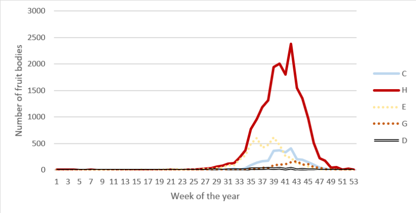
Figure 7. Phenology
Click for a full description
Line graph showing how many records of each CHEGD type per week to look at when the different groups typically fruit. This visualises a broad trend that all of the CHEGD species do not fruit frequently till the 25th week of the year, and that most records of fruitbodies are from Hygrocybe, and the least are from Dermolomas.
- Claveroids peak from week 38 to 43
- Hygrocybe peak from week 33 to 47
- Entoloma peak from week 33 to 41
- Geoglossum peak from week 39 to 47
- Dermoloma peak from week 35 to 44
Churchyard sites
It is quite noticeable that Scotland has significantly fewer churchyard sites with grassland fungi than the other parts of the British Isles and no sites pass one of the SSSI thresholds (Table 15). Wales has 30 qualifying churchyards and England has 24 while Ireland as a whole has only one. This is doubtless partly down to recording effort with less “dedicated” churchyard enthusiasts in Scotland but there it may also be down to the nature of the churchyards.
Table 15. Number of churchyard sites and records in the British Isles
| Country | No Sites | No Records | Sites Passing SSSI Threshold |
|---|---|---|---|
| England | 575 | 7,995 | 24 |
| Wales | 504 | 12,359 | 30 |
| Ireland (NI and RoI) | 315 | 1,755 | 1 |
| Scotland | 113 | 855 | 0 |
The best churchyard sites are listed in Table 16. They are well distributed geographically in Scotland. The best sites are Greenock Cemetery and Cill Chriosd graveyard in Suardal on Skye. With only 13 species of scoring waxcap, they are not even near to SSSI standard however.
Table 16. The best churchyard sites in Scotland sorted by number of SSSI scoring waxcaps
| Site | Vice County | Centroid | C_SSSI | H_SSSI | E_SSSI | G_SSSI | D_SSSI | No Visits | Last Visit |
|---|---|---|---|---|---|---|---|---|---|
| Greenock: Greenock cemetery | Renfrewshire | NS264762 | 4 | 13 | 2 | 2 | 0 | 3 | 01/11/2020 |
| Skye: Suardal: Cill Chriosd graveyard | North Ebudes | NG618207 | 0 | 13 | 12 | 1 | 0 | 2 | 24/09/2000 |
| Grantown-on-Spey: cemetery | Moray | NJ027268 | 1 | 12 | 7 | 1 | 0 | 4 | 14/09/2021 |
| Kirkconnel: St. Conal's Cemetery | Dumfriesshire | NS718122 | 2 | 12 | 2 | 1 | 1 | 1 | 30/10/2021 |
| Fortrose Cathedral | East Ross | NH727565 | 2 | 11 | 2 | 0 | 0 | 2 | 14/10/2021 |
| Glasgow: Lambhill Cemetery | Lanarkshire | NS576697 | 1 | 11 | 4 | 0 | 0 | 1 | 01/11/2014 |
| Melrose Abbey | Roxburghshire | NT548341 | 4 | 11 | 1 | 1 | 0 | 3 | 06/08/2010 |
| Orkney: Mainland: Finstown Cemetery | Orkney | HY365135 | 6 | 11 | 4 | 4 | 0 | 4 | 11/10/2012 |
| Glen Lyon: Innerwick Churchyard | Mid Perthshire | NN588354 | 0 | 10 | 0 | 0 | 0 | 1 | 09/09/2016 |
| Portlethen Old Kirkyard | Kincardineshire | NO923966 | 0 | 10 | 0 | 0 | 0 | 1 | 26/10/2000 |
| Appin Old Churchyard | Argyll | NM939464 | 1 | 9 | 0 | 0 | 0 | 1 | 24/09/2013 |
| Belhelvie Drumhead old kirkyard | South Aberdeenshire | NJ956185 | 0 | 9 | 0 | 0 | 0 | 1 | 09/11/2000 |
| Caddonfoot Church | Selkirkshire | NT451348 | 0 | 9 | 0 | 0 | 0 | 1 | 30/10/1999 |
| Islay: Kildalton Church | South Ebudes | NR458505 | 0 | 9 | 0 | 0 | 0 | 3 | 03/11/2014 |
| Forest of Birse chapel | South Aberdeenshire | NO533905 | 2 | 8 | 0 | 0 | 0 | 3 | 16/10/2021 |
| Foveran: Cemetery on A975 | South Aberdeenshire | NJ984238 | 0 | 8 | 0 | 0 | 0 | 3 | 03/11/2022 |
| Glasgow: Muirend: Merrylee Church | Renfrewshire | NS574602 | 1 | 8 | 0 | 1 | 0 | 3 | 07/12/2014 |
| Largs: Haylie Brae Cemetery | Ayrshire | NS210583 | 1 | 8 | 0 | 0 | 1 | 1 | 17/10/2020 |
| Shetland: Mainland: Tarland Sound Cemetery | Shetland | HU465405 | 3 | 8 | 0 | 0 | 0 | 1 | 05/09/2011 |
Discussion
This database has allowed the identification of many sites of high grassland fungi diversity, and allowed for the comparison of sites. It is believed that this project has indeed produced a useful way to prioritise sites for conservation. There is communication planned for this project both to inform people of its existence and how to use it. In particular, a user’s guide has been created that highlights the most need-to-know information for using and interpreting the data displayed in the mapping tool.
The mapping tool created with this database has the potential to be published in a few different places to make it accessible to NatureScot staff, staff of other conservation agencies, and members of the public. The map also shows that sites of grassland fungi diversity are not evenly distributed across Scotland. In addition to this, the analysis of the phenology of fruiting can be used to plan when fruitbody surveys are best timed.
As mentioned previously, this records collection and ranked database has allowed many sites that surpass the SSSI thresholds to be identified. Scotland indeed has many places of European importance to waxcap and grassland fungi. It is hoped that making the data accessible in the form of the mapping tool will allow landowners to take action to target conservation efforts and maintain grassland management on areas of rich fungal diversity. As part of Scotland’s 30x30 ambitions there is a need to safeguard an extra 12% of Scotland’s terrestrial and freshwater area in line with the 30x30 Framework. Sites included on this list may be able to contribute towards these ambitions either via traditional designations such as SSSIs or Other Effective Area-Based Conservation Measures (OECMs) where there is interest and consent from the land owner/manager. However, most of sites that surpass the thresholds will be not be designated. The data from this database will be used to inform future iterations of the SSSI guidelines.
The larger the dataset, the greater the confidence is in the analysis. Waxcap grasslands are under threat for a variety of reasons including nutrient enrichment, lack of management, inappropriate management and development pressure from tree planting and building. More data increases accuracy and allows better decision making. We are confident that the vast majority of records of grassland fungi that have been made in Scotland have been captured here. There are areas lacking in data due to under-recording and there will be many excellent sites not in this system, but this is part of a larger issue with mycological recording, despite the dedicated efforts of the voluntary recording community.
As the spatial data shows, there are many blank areas and it is hoped that the creation and communication of this map will allow recorders to identify areas with low records, allowing them to target their recording. Defining key sites spatially and making this information widely available would allow the predicted site boundaries to be related to actual areas of grassland without the potential accidental incorporation of non-suitable habitat. Clear site boundaries accessible to recorders would also allow targeted units to record. This is impossible as a purely-desktop exercise as local knowledge is needed, but could be done with the recording community as recording techniques become more advanced.
This database was created in Access, and then exported as Excel sheets and GIS layers. Access has a better ability to enforce data standards and run queries, but Excel is more a widely accessible software.
NatureScot does not typically hold records, and it was accepted at the beginning of this project that a limitation would be the difficulty updating with new records. Keeping the data as clean as possible is critical, and a continual task for new records coming in. This database will be updated with new records every few years.
In terms of the list of scoring CHEGD species, this is a very dynamic time taxonomically in most of these groups and the 2018 JNCC list is already out of date. Updated lists should be incorporated when new records are added. Queries can easily be re-run with an updated species scoring list, and may cause sites to go up or down in importance, but acting with the most up to date data is crucial for biodiversity conservation. Publishing a list of Entoloma and D group species to use would be particularly useful.
At the moment the database uses data collected in the last 50 years (1973-2023) and so it is very possible that some of the sites that have been marked as medium or high importance have undergone land-use changes that have rendered them unsuitable habitat. These should be able to be marked as ‘destroyed’ in future iterations, or their records replaced by more up to date records of consistent absence, if the site has undergone some form of land use change that has reduced its value to grassland fungi (e.g. the area has been fertilised or developed), or if repeated fungi survey at the right time of year found little grassland fungi. This will also serve as an evidence base for the causes and frequency of the destruction of CHEGD rich areas.
While many data sources were sought, only one eDNA record was incorporated into the database. eDNA has got great potential as a future tool, but sites are best compared with like-for-like survey methods. It is hoped that eDNA surveying will become common enough to include in the Grassland Fungi mapping database for Scotland in the future in order to get a better picture of the results given by this method, and the true scope of grassland fungi using a survey method that does not rely solely on fruitbodies. When eDNA data becomes more widely used, it may become apparent that species that were previously thought of as rare are merely rare-fruiters and missed by fruitbody search. At that time, SSSI and Red Lists will be updated to reflect new information, and to reflect any taxonomic changes that may occur, and this database will be updated with the new assessment information.
Project outputs
- Microsoft Access database used in the analysis and from which all Excel and GIS data was derived
- Two Excel files with the following worksheets
ScottishWaxcaps.xlsx
- Records: All cleaned and consolidated records
- Species: List of names, preferred names and scoring names used for CHEGD scoring
- Sites: List of site names with preferred site name, subsite, metasite, CHEGD scores, IUCN and Indicator scores, number of visits, survey effort.
- eDNA Records: Details of all eDNA records
- SubsiteCHEGD: All subsites with full CHEGD scores
- SubsiteCHEGD_SSSI: All subsites with SSSI CHEGD scores
- MetasiteRanking: All Metasites with full CHEGD score
- Metasite_SSSI_Ranking: All Metasites with SSSI CHEGD score
- Data Source Summary: Details of data sources and numbers of records provided
ScottishWaxcapDetails.xlsx
- SSSI_Threshold_List: All sites listed that passed one of more of the CHEGD SSSI thresholds
- Threshold_Analysis: Numbers of sites that passed the different combinations of the five thresholds
- Vice County Records: Vice Counties ranked by numbers of records
- IUCN Records: The IUCN species with numbers of sites recorded from and number of 10km squares recorded from
- IUCN Sites: Sites ranked by number of IUCN species
- Indicator Sites: Sites ranked by number of Indicators (from Bosanquet et al, 2018)
- Indicator analysis: The average H score for each site each species was recorded on. The higher the score, the better indicator value that species will have.
- Phenology: The number of CHEGD records by group for each week
- Records by Year: Annual number of records
- 1km Summary: CHEGD scores for each 1km along with other attributes and a hyperlink to a webpage for that 1km giving more detail e.g. species list
- 10km Summary: CHEGD scores for each 10km along with other attributes and a hyperlink to a webpage for that 10km giving more detail e.g. species list
- Species by 1km square: Species ranked by number of 1km squares recorded on
- Churchyards: All Churchyard sites ranked by CHEGD score
- eDNA New Species: Species recorded by eDNA with no associated fruiting body records
- eDNA New Site Records: Sites with eDNA records but no associated fruiting body records
- eDNA Site Rankings: Sites ranked by eDNA CHEGD score
- eDNA Species NSites: Species recorded by eDNA ranked by number of sites recorded on
- GIS layers in shapefile format
- 10km grid containing full CHEGD scores, SSSI CHEGD scores, numbers of IUCN species, indicators, number of visits, date of last visit, survey effort score. This allows presentation at a larger scale, e.g. national, as the 1km data is difficult to interpret at that level
- 1km grid containing full CHEGD scores, SSSI CHEGD scores, numbers of IUCN species, indicators, number of visits, date of last visit, survey effort score.
- Site centroids with appropriate attributes. It must be noted that as the site centroids are automatically generated via a tool that takes a mean location from all record locations, a bad grid reference or a poor resolution record e.g.10km grid reference, can lead to the site centroid being in a surprising place. Any such oddities should be noted and can be fixed.
- Record data plotted as points. The records can be provided as polygons with the size of the polygon related to the resolution of the record. However, as some records simply have a grid reference of the grid letter e.g. “SX”, these 100km square polygons do confuse this layer. As points they can be plotted in the sea or in England with those points at the bottom left of the grid square they relate to.
- eDNA records plotted as points. This is not available via the mapping tool as there are not enough records but it will published if future updates to this database bring enough eDNA records.
- Set of html reports for the Sites and 10km squares containing detailed results for those entities which can be opened from the Excel spreadsheets or GIS layers to allow deeper analysis. All reports can be created automatically from the database if data is added. These reports are hosted on the NIFG website but this can easily be changed.
References
Ainsworth, A.M., Smith, J.H., Boddy, L., Dentinger, B.T.M., Jordan, M., Parfitt, D., Rogers, H.J. and Skeates, S.J. 2013. Red List of Fungi for Great Britain: Boletaceae. A pilot conservation assessment based on national database records, fruit body morphology and DNA barcoding. Species Status No. 14. Joint Nature Conservation Committee, Peterborough.
Arauzo, S. and Iglesias, P. 2014. La familia Geoglossaceae en la península Ibérica y la Macaronesia. Errotari, 11, 166-259
Arnolds, E. 1980. De oecologie en Sociologie van Wasplaten (Hygrophorus subgenus Hygrocybe sensu lato). Natura,17-44.
Bosanquet, S.D.S., Ainsworth, A.M., Cooch, S.P., Genney, D.R. and Wilkins, T.C. 2018. Guidelines for the Selection of Biological SSSIs. Part 2: Detailed Guidelines for Habitats and Species Groups. Chapter 14 Non-lichenised Fungi. Joint Nature Conservation Committee, Peterborough.
Geesteranus, M. 1965. Geoglossaceae of India and Adjacent Countries. Persoonia 4(1), 19-46
Legon N.W. and Henrici A. 2005. Checklist of the British & Irish Basidiomycota. Royal Botanic Gardens Kew.
Newton A.C., Davy L.M., Holden E., Silverside A., Watling R. and Ward S.D. 2003. Status, distribution and definition of mycologically important grasslands in Scotland. Biological Conservation, 111(1), 11-23
Roberts, P. 2015. Provisional key to clavarioid fungi in British grasslands (revised draft). Unpublished.
Spooner, B. 1998. Keys to the British Geoglossaceae (draft). Unpublished key for BMS.
Annex 1. British grassland waxcap (Hygrocybe s.l.) with high diversity indicator species (after the guidelines for SSSI selection by Bosanquet et al. 2018)
Table A1. Taxon name for scoring, and the current name under recent taxonomy, for the British grassland waxcaps, and whether they are defined as a high diversity indicator in the SSSI selection guidelines (Bosanquet et al. 2018)
| Taxon name for scoring (as defined in Boertmann, 2010 unless otherwise stated) | Current name (following Ainsworth & Henrici, 2016; Ainsworth, 2017b) | Highdiversity indicator. |
|---|---|---|
| Hygrocybe acutoconica var. acutoconica (excl. H. aurantiolutescens, a sand dunesp.) | Hygrocybe acutoconica var. acutoconica | - |
Hygrocybe acutoconica var. konradii (incl. f. subglobispora) | Hygrocybe acutoconica var. konradii | - |
| Hygrocybe aurantia | Cuphophyllus aurantius | - |
| Hygrocybe aurantiosplendens | Hygrocybe aurantiosplendens | Yes |
| Hygrocybe calciphila | Hygrocybe calciphila | - |
| Hygrocybe calyptriformis | Porpolomopsis calyptriformis | Yes |
| Hygrocybe canescens | Cuphophyllus canescens | Yes |
| Hygrocybe cantharellus | Hygrocybe cantharellus (s. Boertmann and British authors) | - |
| Hygrocybe ceracea | Hygrocybe ceracea | - |
| Hygrocybe chlorophana | Hygrocybe chlorophana | - |
| Hygrocybe citrinovirens | Hygrocybe citrinovirens | Yes |
| Hygrocybe coccinea (excl. H. marchii s. Boertmann, 1995) | Hygrocybe coccinea | - |
| Hygrocybe colemanniana | Cuphophyllus colemannianus | Yes |
| Hygrocybe conica var. conica | Hygrocybe conica | - |
| Hygrocybe constrictospora | Hygrocybe constrictospora | - |
| Hygrocybe flavipes (excl. H. radiata) | Cuphophyllus flavipes | Yes |
| Hygrocybe fornicata var. fornicata | Cuphophyllus fornicatus | - |
| Hygrocybe fornicata var. lepidopus | Cuphophyllus lepidopus | - |
| Hygrocybe glutinipes | Hygrocybe glutinipes | - |
| Hygrocybe helobia | Hygrocybe helobia | - |
| Hygrocybe ingrata | Neohygrocybe ingrata | Yes |
| Hygrocybe insipida | Hygrocybe insipida | - |
| Hygrocybe intermedia | Hygrocybe intermedia | Yes |
| Hygrocybe irrigata | Gliophorus irrigatus | - |
| Hygrocybe lacmus | Cuphophyllus lacmus | Yes |
| Hygrocybe laeta | Gliophorus laetus | - |
| Hygrocybe marchii (s. Boertmann, 1995) | Hygrocybe marchii (s. Boertmann, 1995) | - |
| Hygrocybe miniata | Hygrocybe miniata | - |
| Hygrocybe mucronella | Hygrocybe mucronella | - |
| Hygrocybe nitrata | Neohygrocybe nitrata | Yes |
| Hygrocybe ovina | Neohygrocybe ovina | Yes |
| Hygrocybe phaeococcinea | Hygrocybe phaeococcinea | - |
| Hygrocybe pratensis var. pratensis | Cuphophyllus pratensis | - |
| Hygrocybe pratensis var. pallida | Cuphophyllus pratensis var. pallidus | - |
| Hygrocybe psittacina var. psittacina | Gliophorus psittacinus | - |
Hygrocybe psittacina var. psittacina unnamed form | Gliophorus reginae | - |
| Hygrocybe psittacina var. perplexa | Gliophorus europerplexus, G. perplexus aff. | - |
| Hygrocybe punicea | Hygrocybe punicea | Yes |
| Hygrocybe quieta | Hygrocybe quieta | - |
| Hygrocybe radiata (s. Boertmann, 1995) | Cuphophyllus radiatus | - |
| Hygrocybe reidii | Hygrocybe reidii | - |
| Hygrocybe russocoriacea | Cuphophyllus russocoriaceus | - |
| Hygrocybe spadicea | Hygrocybe spadicea | Yes |
| Hygrocybe splendidissima | Hygrocybe splendidissima | Yes |
| Hygrocybe subpapillata | Hygrocybe subpapillata | Yes |
| Hygrocybe substrangulata | Hygrocybe substrangulata | - |
| Hygrocybe turunda | Hygrocybe turunda | Yes |
| Hygrocybe virginea | Cuphophyllus virgineus | - |
| Hygrocybe vitellina | Gloioxanthomyces vitellinus | - |
Annex 2. SSSI selection thresholds for grassland fungi (after Bosanquet et al. 2018)
Table A2. SSSI selection thresholds for Clavarioid fungi, Hygrocybe sensu lato, Entoloma sensu lato, geoglossoid fungi, and Dermoloma and associates.
| Group, genus or genera | Englishname | Threshold |
|---|---|---|
| Clavarioid fungi | clubs, spindles and corals | 7 |
| Hygrocybe s.l. | Waxcaps | 19 |
| Entoloma s.l. | Pinkgills | 15 |
| Geoglossoid fungi | Earthtongues | 5 |
| Dermoloma, Camarophyllopsis, Hodophilus, Porpoloma (Pseudotricholoma metapodium) | crazed caps, fanvaults and meadowcaps | 3 |
Annex 3. Clubs, spindles and corals (clavarioid fungi), as defined by Roberts (2015), alongside their current names (Legon & Henrici) (after Bosanquet et al. 2018)
Table A3. Taxon name for scoring, and the current name under recent taxonomy, for the British clavaroid fungi.
| Taxon for scoring | Current name |
|---|---|
| Clavaria acuta | Clavaria falcata agg. |
| Clavaria amoenoides | Clavaria inaequalis |
| Clavaria asperulispora | Clavaria asperulispora |
| Clavaria atroumbrina | Clavaria atroumbrina s. auct. Brit. |
| Clavaria fragilis | Clavaria fragilis agg. |
| Clavaria fumosa | Clavaria fumosa |
| Clavaria greletii | Clavaria greletii |
| Clavaria incarnata | Clavaria incarnata |
| Clavaria rosea | Clavaria rosea |
| Clavaria straminea | Clavaria flavipes |
| Clavaria tenuipes | Clavaria tenuipes |
| Clavaria zollingeri | Clavaria zollingeri |
| Clavulinopsis corniculata | Clavulinopsis corniculate |
| Clavulinopsis fusiformis | Clavulinopsis fusiformis |
| Clavulinopsis helvola | Clavulinopsis helvola |
| Clavulinopsis laeticolor | Clavulinopsis laeticolor |
| Clavulinopsis luteoalba | Clavulinopsis luteoalba |
| Clavulinopsis luteonana | Ramariopsis luteonana |
| Clavulinopsis umbrinella | Clavulinopsis umbrinella |
| Ramariopsis crocea | Ramariopsis crocea |
| Ramariopsis kunzei | Ramariopsis kunzei |
| Ramariopsis minutula | Ramariopsis minutula |
| Ramariopsis pulchella | Ramariopsis pulchella |
| Ramariopsis subtilis | Ramariopsis subtilis |
| Ramariopsis tenuiramosa | Ramariopsis tenuiramosa |
Annex 4. Earthtongue (geoglossoid fungi), as defined by Spooner (1998), alongside their current names
Table A4. Taxon name for scoring, and the current name under recent taxonomy, for the British geoglossoid fungi.
| Taxon forscoring | Current name |
|---|---|
| Geoglossum barlae | Geoglossum barlae |
| Geoglossum cookeanum | Geoglossum cookeanum |
| * | *Geoglossum difforme |
| Geoglossum elongatum | Geoglossum elongatum |
| Geoglossum fallax | Geoglossum fallax |
| Geoglossum littorale | Geoglossum littorale |
| Geoglossum nigritum | Geoglossum nigritum |
| Geoglossum simile | Geoglossum simile |
| Geoglossum starbaeckii | Geoglossum starbaeckii |
| Geoglossum umbratile | Geoglossum umbratile |
| Geoglossum vleugelianum | Geoglossum vleugelianum |
| Geoglossum glutinosum | Glutinoglossum glutinosum |
| Geoglossum atropurpureum | Microglossum atropurpureum agg. |
| Microglossum olivaceum | Microglossum olivaceum agg. |
| Trichoglossum hirsutum | Trichoglossum hirsutum |
| Trichoglossum rasum | Trichoglossum rasum |
| Trichoglossum tetrasporum | Trichoglossum tetrasporum |
| Trichoglossum variabile | Trichoglossum variabile |
| Trichoglossum walteri | Trichoglossum walteri |
*Geoglossum difforme – added to this list since SSSI Guidelines, (Bosanquet et al. 2018); recognised UK species and IUCN Red List.
Annex 5. IUCN Red List species (NT-CR) as of 28 Feb 2020
Table A5. List of CHEGD species on the ICUN global Red List, and their Status.
| - | Name in IUCN global Red List | Status |
|---|---|---|
| 1 | Clavaria zollingeri | VU |
| 2 | Cuphophyllus canescens | VU |
| 3 | Cuphophyllus colemannianus | VU |
| 4 | Cuphophyllus lacmus | VU |
| 5 | Cuphophyllus lepidopus | VU |
| 6 | Entoloma bloxamii sensu lato | VU |
| 7 | Entoloma excentricum | NT |
| 8 | Entoloma griseocyaneum | VU |
| 9 | Entoloma porphyrophaeum | VU |
| 10 | Entoloma prunuloides | VU |
| 11 | Geoglossum difforme sensu lato | NT |
| 12 | Gliophorus europerplexus | VU |
| 13 | Gliophorus reginae | VU |
| 14 | Gloioxanthomyces vitellinus | EN |
| 15 | Hygrocybe citrinovirens | VU |
| 16 | Hygrocybe ingrata | VU |
| 17 | Hygrocybe ovina | VU |
| 18 | Hygrocybe punicea | VU |
| 19 | Hygrocybe spadicea | VU |
| 20 | Hygrocybe splendidissima | VU |
| 21 | Microglossum atropurpureum sensu lato | VU |
| 22 | Neohygrocybe nitrata | VU |
| 23 | Porpolomopsis calyptriformis | VU |
| 24 | Pseudotricholoma metapodium | EN |
| 25 | Trichoglossum walteri sensu lato | VU |