Landscape character assessment (LCA) 2019: Summary of main differences to 1990s LCAs
Published: 2019
The changes maps are organised primarily in alphabetical order of the 1990s LCA report areas, with the exception of those in Highland Council area which have been grouped together. Note that several have been amalgamated, such as South & Central Aberdeenshire and Banff & Buchan which are now Aberdeenshire.
Original LCT names are shown in italics and current LCT names in “quotation marks”.
1. Aberdeen City
The 1997 Aberdeen LCA report was based on LC Areas rather than LCTs. The general changes since this time which are incorporated into the new LCA are:
- Revision of the urban area to show new housing, business and industrial expansion, roads and port development.
- General refinement to boundaries using the more detailed GIS mapping.
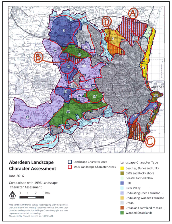
Map of Aberdeen City - Boundary changes to LCTs, as shown on the map, are:
Click for a full description
A. Area of “Undulating Open Farmland” at Potterton / Perwinnes, which was two separate LC Areas in the 1997 LCA report, simplified to make one larger area.
B. Area at East Elrick, which was Area 13 in the 1997 LCA report, has been amalgamated into adjacent areas, now forming parts of “Low Hills - Aberdeen”, “Wooded Estates – Aberdeen” and “Undulating Open Farmland”.
C. The area around Loirston, which was one LC Area (27. Loirston) has been subdivided to reflect differences in character, now forming part of the “Urban and Farmland” LCT at Loirston, part of the “Coastal Farmed Plain” LCT at Findon, and a large section of “Urban” between these two.
D. A large section of River Valley north of Aberdeen has been incorporated into “Undulating Wooded Farmland”.
2. Aberdeenshire
The Banff & Buchan and South & Central Aberdeenshire 1990s LCA reports were extensively reviewed. This was undertaken by a landscape consultant, funded by NatureScot and Scottish Forestry, in consultation with Aberdeenshire Council. The revisions addressed the following aspects:
- The grain of both Banff & Buchan and South & Central Aberdeenshire LCA reports. These were very broad, with only four LCTs for Banff & Buchan, and five for South & Central Aberdeenshire – far fewer than many other areas in Scotland.
- Better cross boundary continuity with adjacent local authority areas.
In more detail, the changes are as follows:
Coastal
- Amalgamate the South & Central Aberdeenshire Kincardine Cliffs, Aberdeenshire Moray Firth Cliffs and North Sea Cliffs into a single LCT called “Cliffs and Rocky Coast”.
- Combine the South & Central Aberdeenshire coastal areas of the Formartine Links and Dunes and Dunes and Beaches from Fraserburgh to Peterhead, which have similar key characteristics, into a single LCT called “Beaches, Dunes and Links – Aberdeenshire”.
- The Kincardine Links Landscape Character Area defined in the South & Central
Aberdeenshire LCA has been re-defined it as a separate LCT called “Raised Beach Coast – Aberdeenshire”.
Farmland
Amalgamate the Howe of Cromar, Insch Basin and Howe of Alford LCAreas, (part of the Agricultural Heartlands LCT) which are similar in character (farmed basins surrounded by uplands) to form a broader LCT named “Farmed Basins”. In the original Agricultural Heartlands LCT the Howe of Mearns LCArea has been amalgamated with “Broad Valley Lowlands” (Strathmore) LCT classified in the Tayside LCA, of which it forms an extension.
- The “Farmed Rolling Ridges and Hills” continue into north Aberdeenshire (formerly part of the Banff & Buchan LCA) and the description of this LCT has been supplemented to pick up relevant features present in the south.
- All three landscape character areas within the Farmed Moorland Edge have been amalgamated with a single description and the LCT is now called “Farmed Moorland Edge – Aberdeenshire”. The variations in character of the Cromar area have been noted in the revised description.
- Amalgamate the Formartine Lowlands (South & Central Aberdeenshire) with the Eastern Coastal Agricultural Plain in North Aberdeenshire (formerly Banff & Buchan LCA) to create a new LCT – “Coastal Agricultural Plain”.
Valleys
- Extend the Deeside LCArea east of Banchory to the edge of Aberdeen, and rename it “Broad Wooded and Farmed Valley” to provide a more logical link with the Aberdeen City LCA “River Valleys – Aberdeen”.
- Amalgamate the Deveron and Bogie Straths Landscape Character Area (South & Central Aberdeenshire) and the Deveron and Ythan Straths in north Aberdeenshire (formerly Banff & Buchan LCA) to create “Farmed and Wooded River Valleys” LCT.
3. Argyll & Firth of Clyde
General Change
Areas now within Loch Lomond and the Trossachs National Park were omitted.
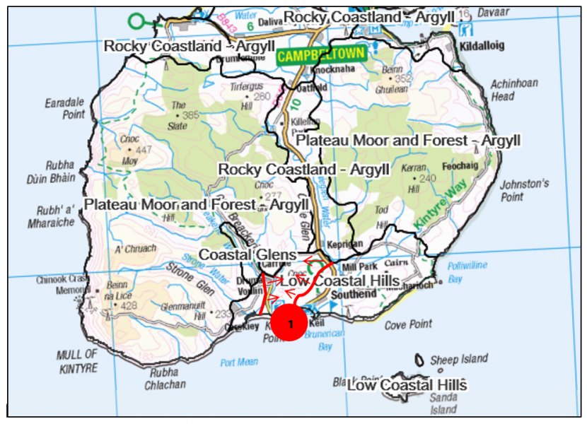
Map of Argyll
Click for a full description
1. Area of Rocky Mosaic (renamed “Rocky Coastland – Argyll”) on southern tip of Kintyre changed to “Low Coastal Hills”.
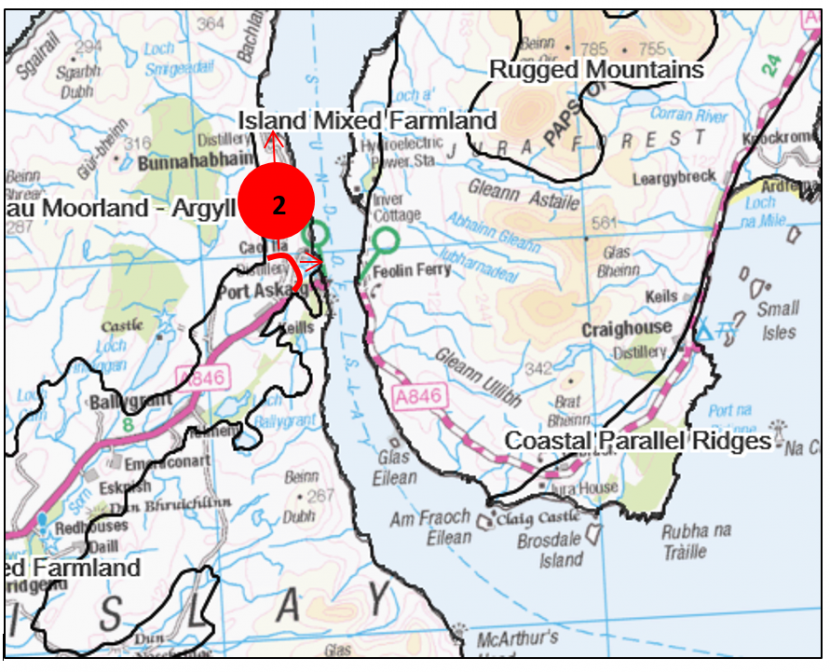
Map of Argyll
Click for a full description
2. “Island Mixed Farmland” on east of Islay extended northwards into Moorland Plateau (renamed “Plateau Moorland – Argyll”).
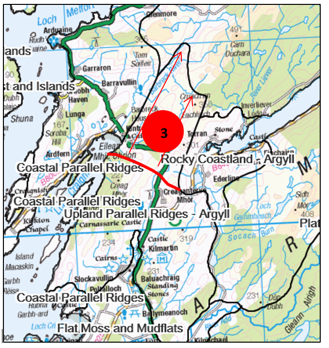
Map of Argyll
Click for a full description
3. “Upland Parallel Ridges – Argyll” extended northwards into part of “Craggy Upland – Argyll” north of Kilmartin.
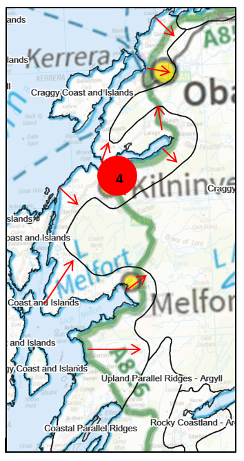
Map of Argyll
Click for a full description
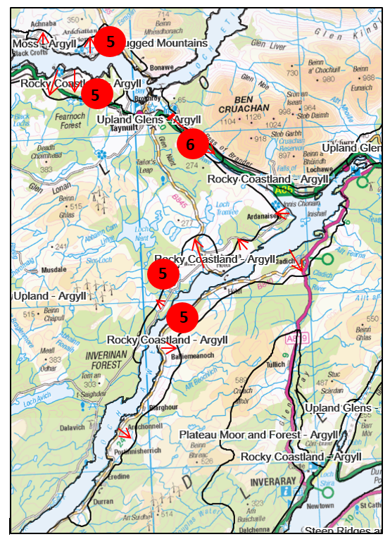
4. Mainland parts of what was Craggy Upland on coast north and south of Oban redefined as “Craggy Coasts and Islands”.
Islands off this coast, which were originally Slate Islands, renamed “Craggy Coasts and Islands”.
Map of Argyll
Click for a full description
5. “Rocky Coastland” introduced along edges of Loch Awe, Loch Fyne and coastline east of Connel.
6. “Upland Glens – Argyll” (were Mountain Glens) extended southwards down Pass of Brander.
Map of Argyll
Click for a full description
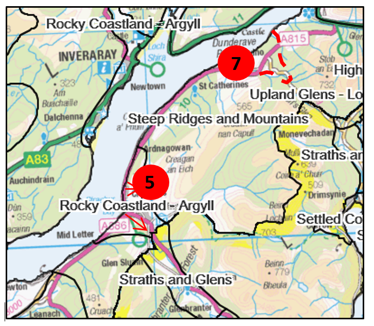
5. “Rocky Coastland” introduced along edges of Loch Awe, Loch Fyne and coastline east of Connel.
7. Small area of Open Ridgeland redefined as “Steep Ridges and Mountains”.
Map of Firth of Clyde
Click for a full description
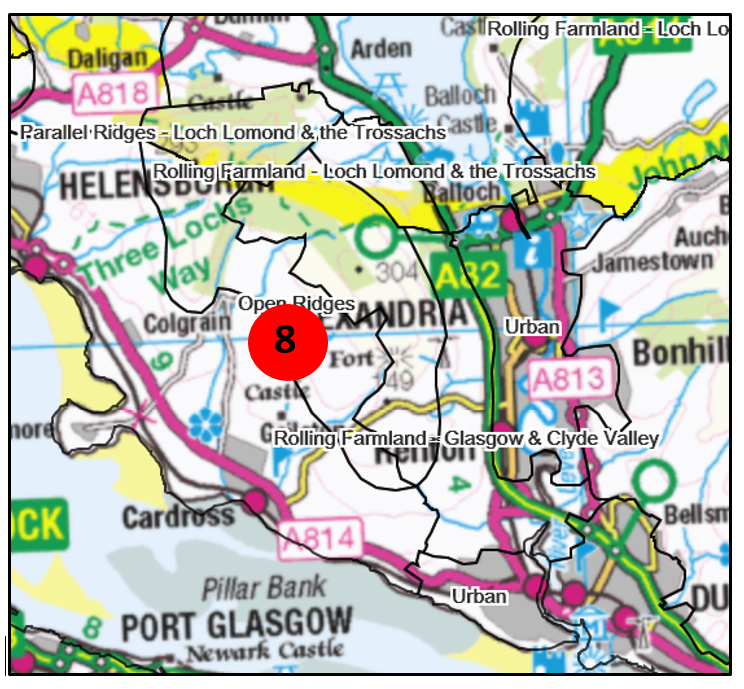
8. Boundaries of “Open Ridges” (originally Open Ridgeland) and “Rolling Farmland with Estates” realigned at junctions with LLTNP and Glasgow & the Clyde Valley.
4. Ayrshire
East Ayrshire
Map of East Ayrshire
Click for a full description
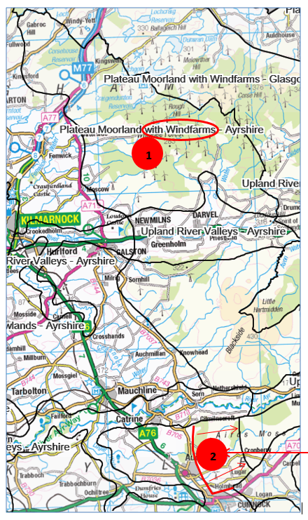
1. Plateau Moorland with Forestry now “Plateau Moorland with Windfarms”.
2. “Plateau Moorland –Ayrshire” (was Plateau Moorlands) boundary moved eastwards into “Agricultural Lowlands – Ayrshire”.
North Ayrshire
No changes.
South Ayrshire
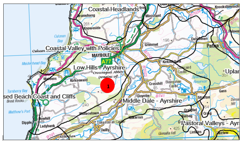
Map of South Ayrshire
Click for a full description
1. Area of Foothills in Maybole area redefined as separate “Low Hills - Ayrshire” LCT.
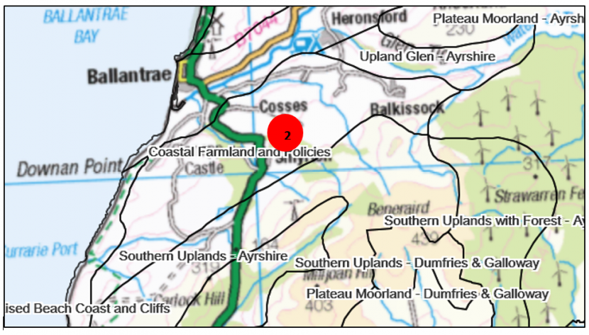
Map of South Ayrshire
Click for a full description
2. Area of Plateau Moorlands redefined as “Coastal Farmland and Policies”.
5. Borders
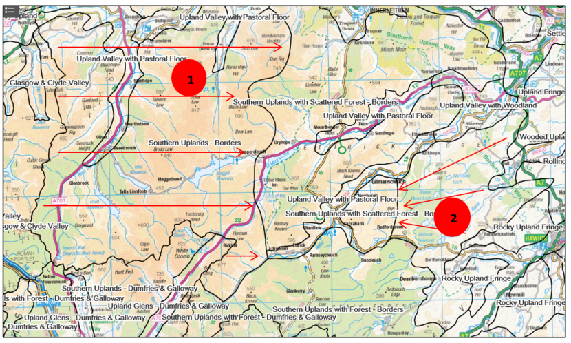
Map of Borders
Click for a full description
1. Part of Southern Uplands with Scattered Forest redefined to create new area of “Southern Uplands – Borders”. Boundary moved eastwards.
2. Part of Southern Uplands with Scattered Forest redefined to create new LCT “Rolling Moorland”. Boundary moved west and north.
6. Cairngorms National Park
The first LCA for the Cairngorms was published in 1996, preceding designation of the National Park. Other LCAs (Tayside 1999, for example) also assessed landscapes which were subsequently incorporated into the Park.
The Cairngorms National Park Authority (CNPA) commissioned a new LCA in 2009 to cover the Park area. This was done at Landscape Character Area level – more detailed than the national dataset which is at LCT level – and incorporated additional information, such as Historic Land Use Assessment.
The ninety 2009 LCAreas were grouped into 12 new LCTs in the SNH 2019 dataset. The new LCT character descriptions were written using information from the 2009 LCArea character descriptions. The LCArea boundaries were used as the basis for the new LCT boundaries and they therefore nest with each other. The whole process was carried out in partnership with the Landscape Advisors at the CNPA.
The main differences between the 1996 and 2019 LCTs are:
- Subdivision of the wide-ranging Uplands and Glens LCT into “Summits and Plateaux – Cairngorms”, “Rolling Uplands – Cairngorms”, “Smooth Rounded Hills”, “Upland Basin - Cairngorms” and “Upland Glen – Cairngorms”.
- Identification of mountain fringe areas on the western edge of the Cairngorms Massif as “Forested Upland Fringe”.
- Subdivision of the “Straths” LCT into “Upland Strath”, “Broad Glen with Estates” (in Deeside, Donside and around Blair Atholl), “Upland Glen – Cairngorms”, “Farmed Straths and Glens” and “Undulating Wooded Farmland”.
7. Central Region
General change – “Stirling to Grangemouth” and “Central Region” LCAs combined.
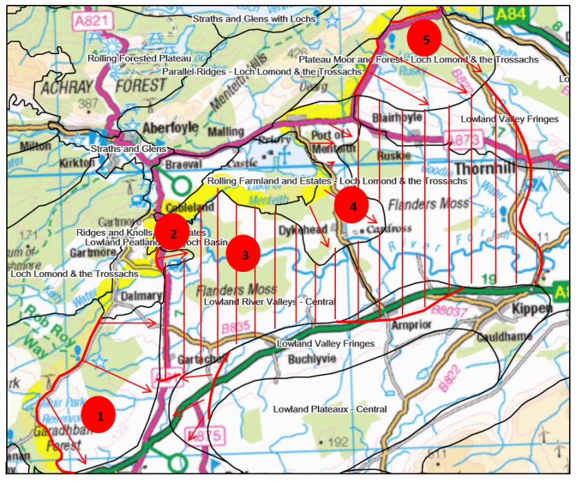
Map of Central Region
Click for a full description
1.”Plateau Moor and Forest – Loch Lomond & the Trossachs” LCT extends into Stirling Council area.
2. “Ridges and Knolls with Estates” extends from Loch Lomond and the Trossachs National Park into Stirling Council area.
3. Hatched area not covered by 1990s LCAs redefined to fit with newer Stirling Council LCA.
4.”Rolling Farmland and Estates – Loch Lomond & the Trossachs” extends into Stirling Council area.
5.”Plateau Moor and Forest – Loch Lomond & the Trossachs” extends into Stirling Council area.
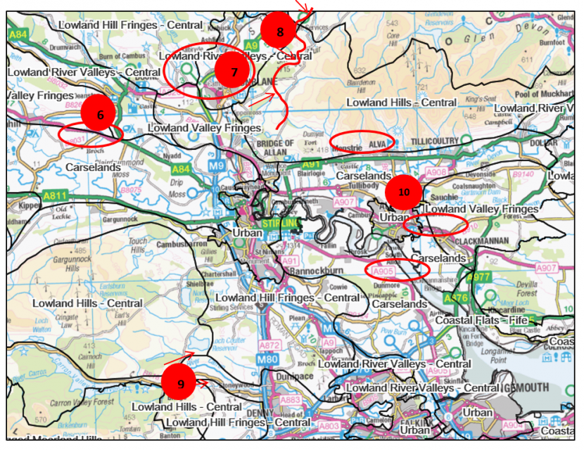
Map of Central Region
Click for a full description
6. Several Lowland River Valleys redefined as “Carselands”. Part of area north of Grangemouth reclassified from Coastal Margins.
7. Boundary alignment of “Lowland Valley Fringes” and “Lowland River Valleys –Central” amended to better accord with newer Stirling Council LCA.
8. Western end of Ochil Hills redefined to “Lowland Hill Fringes – Central”
9. Area of Lowland Hill Fringes now “Lowland Hills-Central”.
10. Alloa redefined to “Urban”.
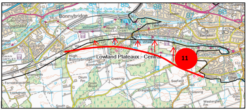
Map of Central Region
Click for a full description
11. Southern alignment of “Lowland River Valley – Central” moved north.
8. Dumfries & Galloway
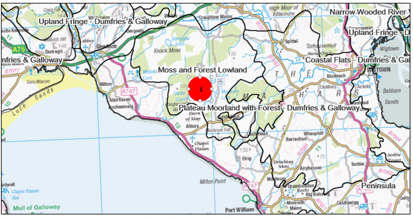
Map of Dumfries & Galloway
Click for a full description
1. Mochrum area of Plateau Moorland redefined as “Moss and Forest Lowland”.
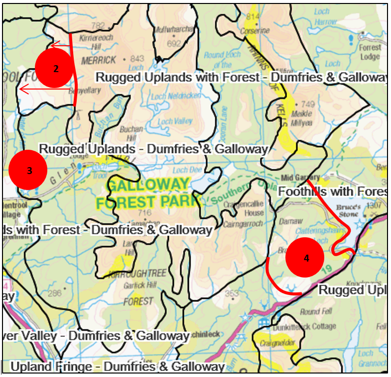
Map of Dumfries & Galloway
Click for a full description
2. Small area of Southern Uplands now “Rugged Uplands – Dumfries & Galloway”.
3. Area of Rugged Uplands now “Rugged Uplands with Forest”.
4. Area of Southern Uplands with Forest now “Foothills with Forest – Dumfries & Galloway”.
Map of Dumfries & Galloway
Click for a full description
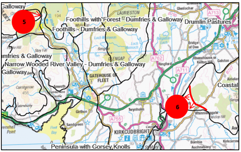
5. Small area of Foothills with Forest now “Coastal Uplands”.
6. Small area of Peninsula now “Coastal Uplands”.
Map of Dumfries & Galloway
Click for a full description
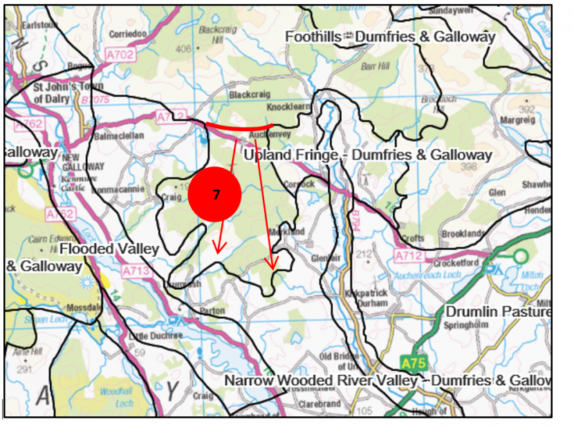
7. Area of Upland Fringe redefined as “Foothills with Forest – Dumfries & Galloway”.
9. Fife
General changes
Urban category removed for settlements of less than around 25,000 to accord with national approach.
Map of Fife
Click for a full description
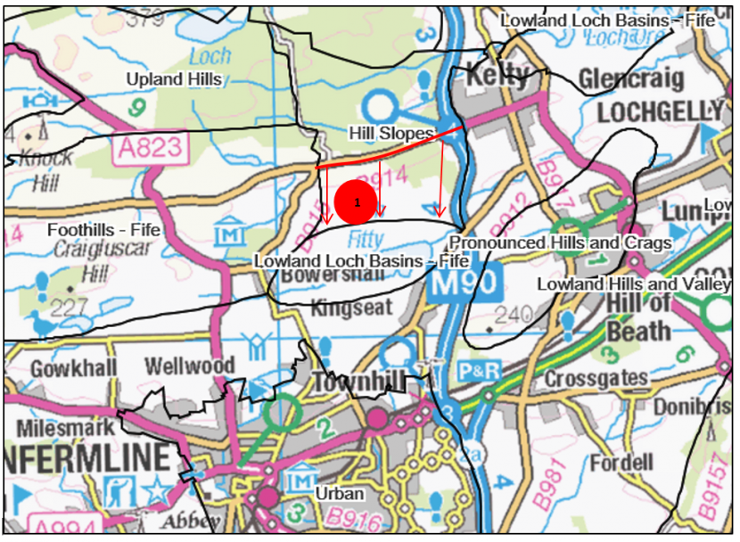
1. “Hill Slopes” extended southwards towards Loch Fitty.
10. Glasgow & The Clyde Valley
General changes
- Urban areas updated to reflect current development patterns.
- Green Corridors LCT deleted as much now within urban area.
For council areas where no changes have taken place there are no maps.
Map of East Renfrewshire
Click for a full description
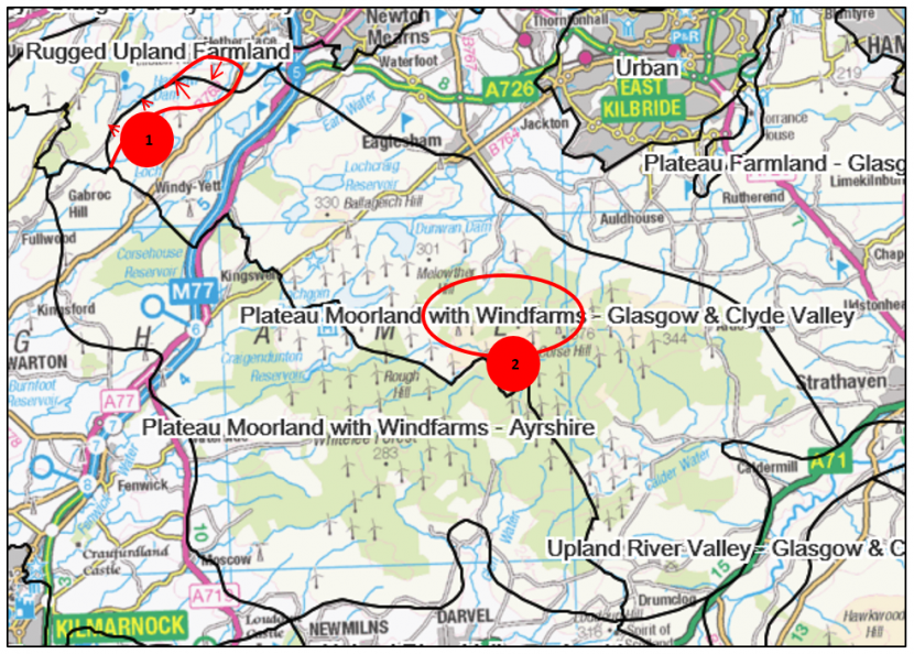
1. Re-alignment between “Plateau Moorland with Windfarms – Glasgow & Clyde Valley” and “Rugged Upland Farmland”.
2. Plateau Moorland now “Plateau Moorland with Windfarms – Glasgow & Clyde Valley”.
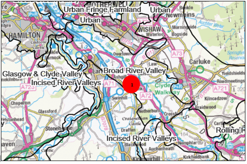
Map of North Lanarkshire
Click for a full description
1. Area which was Incised River Valley now redefined as “Broad River Valley”.
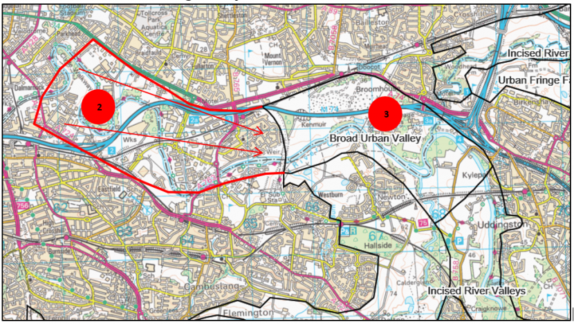
Map of South Lanarkshire and Glasgow City
Click for a full description
2. Area of original Broad Urban Valley now incorporated into “Urban” area.
3. Incised Urban Valley reduced and Broad Urban Valley made wider.
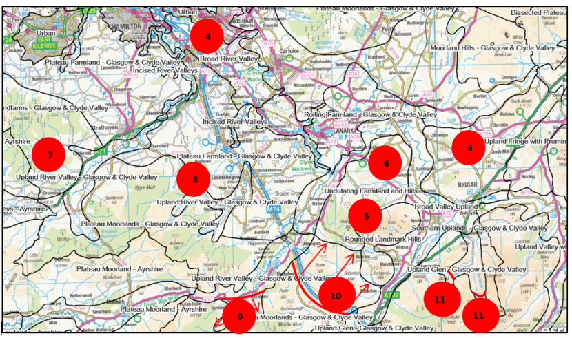
Map of South Lanarkshire and Glasgow City
Click for a full description
4. Incised River Valley redfined as “Broad River Valley”.
5. Tinto and Dungavel Hills redefined from Foothills to “Rounded Landmark Hills”.
6. Original Foothills now “Undulating Farmland and Hills”. Tinto and Dungavel Hills moved to separate LCT.
7. Plateau Moorland now “Plateau Moorland with Windfarms – Glasgow & Clyde Valley”.
8. Area of Plateau Farmland near Lesmahagow now within “Upland River Valley – Glasgow & Clyde Valley”.
9. “Upland River Valley – Glasgow & Clyde Valley” extended southwards.
10. Boundary of “Plateau Moorland – Glasgow & Clyde Valley” moved northwards.
11. “Upland Glen – Glasgow & Clyde Valley” extended southwards and westwards.
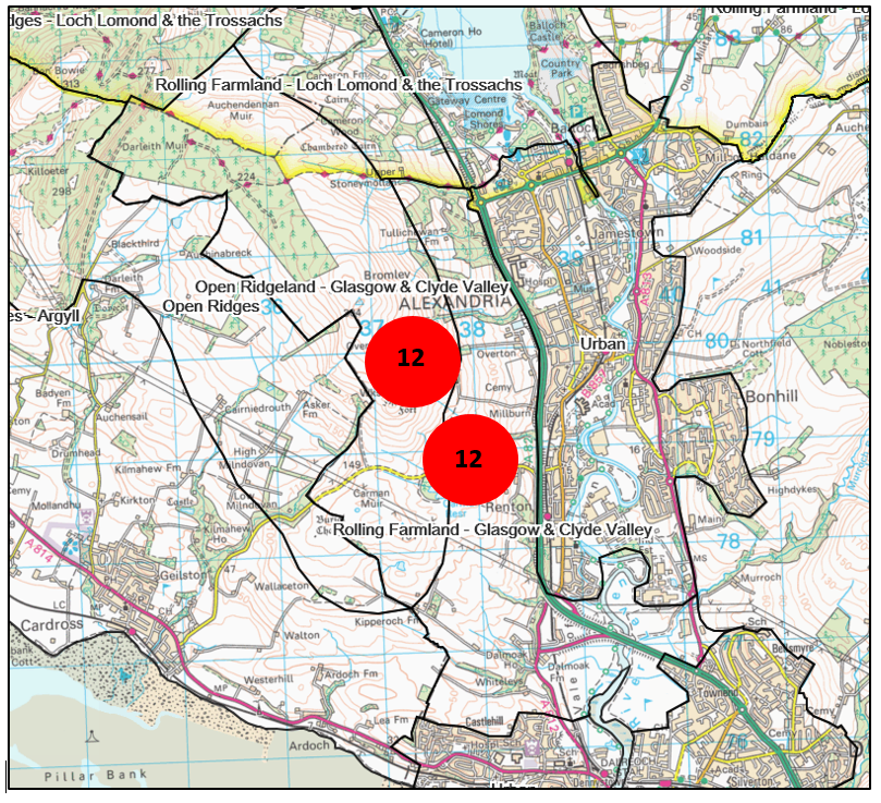
Map of a) West Dunbartonshire
Click for a full description
12. Realignment of LCTs along borders with Argyll & Bute and Loch Lomond & the Trossachs National Park to recognise “Open Ridgeland – Glasgow & Clyde Valley” and “Rolling Farmland – Glasgow & Clyde Valley” where there was only Moorland Hills and Ridges.
11. Highland
a) Badenoch and Strathspey - Ben Alder, Ardverikie and Creag Meagaidh
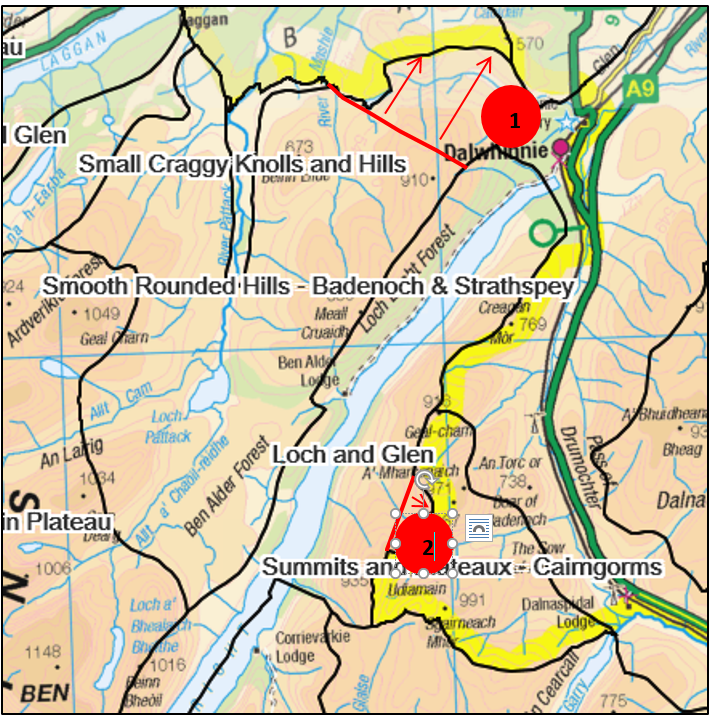
Map of a) Badenoch and Strathspey - Ben Alder, Ardverikie and Creag Meagaidh
Click for a full description
1.”Smooth Rounded Hills” northern boundary extended northwards to National Park boundary.
2. Small area which was Smooth Rounded Hills adjacent to National Park incorporated into “Loch and Glen”.
b) Caithness & Sutherland
The 1998 Landscape Character Assessment was extensively reviewed. This was undertaken by a landscape consultant, funded by SNH and FCS, in consultation with The Highland Council. The revisions addressed the following aspects:
- LCTs simplified and the grain broadened, especially near to the coasts and in moorland/peatland areas.
- Land use based LCTs incorporated in relevant LCTs, e.g. Coniferous Woodland, Broadleaf or Mixed Woodland, Mixed Agriculture and Settlement, Crofting.
- Urban category removed – there are no settlements over the 25K population threshold.
Marine LCTs removed, e.g. Kyles, Firths and Sounds.
c) Inverness
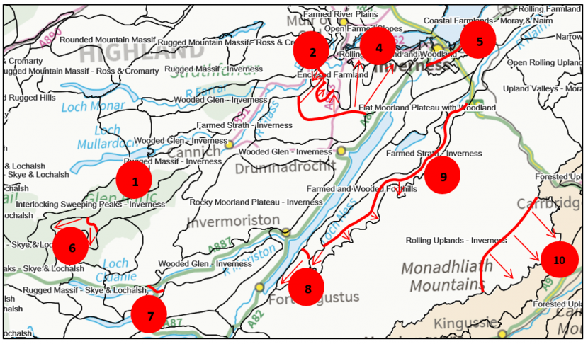
Map of c) Inverness
Click for a full description
1. Area of Rugged Massif now “Interlocking Sweeping Peaks – Inverness”.
2. Original Enclosed Farmland and Crofting Settlement LCTs amalgamated into “Enclosed Farming”. Boundaries amended slightly.
4. Rocky Moorland Plateau and Rocky Moorland Plateau with Woodland combined into “Rocky Moorland Plateau – Inverness”.
5. City boundary redefined reflecting settlement expansion.
6. “Wooded Glen - Inverness” extended at western end of Glen Affric.
7. “Wooded Glen – Inverness” extended at western end of Glen Morriston.
8. Extension of “Farmed and Wooded Foothills” southwards.
9. Realignment of eastern edges of “Farmed Strath – Inverness”.
10. Realignment of edge of “Rolling Uplands” to follow changes in Cairngorms National Park boundary.
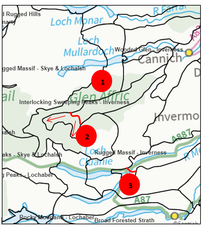
Map of c) Inverness
Click for a full description
1. Area of Rugged Massif redefined as “Interlocking Sweeping Peaks – Inverness”.
2. ”Wooded Glen – Inverness” extended at western end of Glen Affric.
3. ”Wooded Glen- Inverness” extended at western end of Glen Morriston.
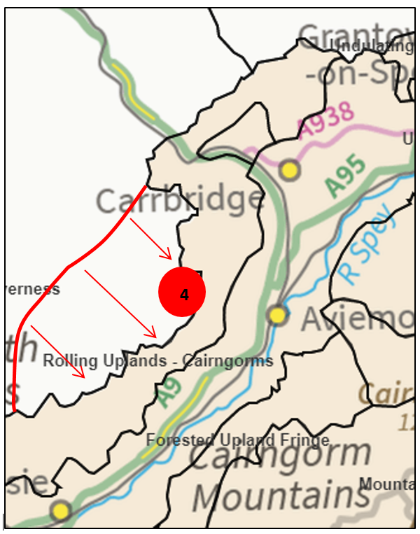
Map of c) Inverness
Click for a full description
4. Realignment of edge of “Rolling Uplands” to follow changes in Cairngorms National Park boundary.
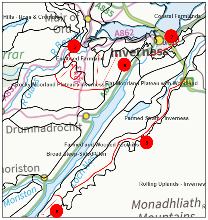
Map of c) Inverness
Click for a full description
5 Enclosed Farmland and Crofting Settlement LCTs amalgamated into “Enclosed Farming”. Boundaries amended slightly.
6. Rocky Moorland Plateau and Rocky Moorland Plateau with Woodland combined into “Rocky Moorland Plateau – Inverness”.
7. City boundary redefined reflecting settlement
8. “Farmed and Wooded Foothills” extended southwards.
9. Realignment of eastern edges of “Farmed Strath – Inverness”.
d) Lochaber
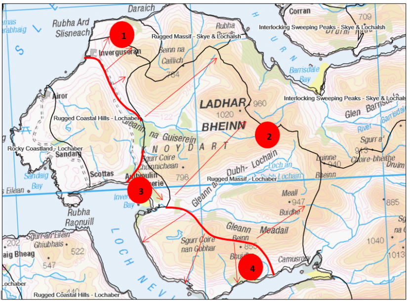
Map of d) Lochaber
Click for a full description
1. ”Rugged Coastal Hills – Lochaber” extended northwards into area originally Interlocking Sweeping Peaks.
2. Part of Interlocking Sweeping Peaks redefined as “Rugged Massif – Lochaber”.
3. Area of Interlocking Sweeping Peaks redefined and incorporated into “Rugged Coastal Hills – Lochaber”.
4. Area of Rugged Coastal Hills redefined as “Rugged Massif – Lochaber”.
e) Ross and Cromarty (and the Northern Inner Moray Firth)
Ross and Cromarty
The 1999 Landscape Character Assessment report was extensively reviewed along with the Northern Inner Moray Firth report, with which it was combined. This was undertaken by a landscape consultant, funded by SNH and FCS, in consultation with The Highland Council. The revisions addressed the following aspects:
- Cross-boundary integration with Caithness & Sutherland, Skye & Lochalsh, and Inverness District LCA studies.
- Areas adjoining Skye and Lochalsh which were previously Rounded Hills have been redefined as “Rugged Mountain Massif – Ross & Cromarty”.
- High Rocky Moorland Foothills have been redefined as “Rugged Mountain Massif - Ross & Cromarty” in a few places, primarily southern and western areas.
- Rugged Mountain Massif margins have been redefined as either “High Rocky Moorland and Plateau” or “Rocky Moorland and Rugged Hills”.
- “High Rocky Moorland Plateau – Ross & Cromarty” incorporates higher areas of Undulating Moorland.
- The Rounded Hills have been subdivided into “Rounded Mountain Massif”, “Rounded Hills and Moorland Slopes – Ross & Cromarty”, and “Rounded Rocky Hills – Ross & Cromarty”.
- “Rounded Hills and Moorland Slopes – Ross & Cromarty” incorporate the isolated, high, smooth “Undulating Moorland” type.
- All western low coastal moorland types, except for Cnocan (which is retained as “Cnocan”) are combined to form a new LCT of “Coastal Moorland and Crofts”, which also incorporates adjacent settlements.
- “Wooded and Settled Rocky Coasts” is identified as a new LCT found on the west coast, and incorporates harbour and crofting settlements.
- Two large settlements not fitting the above two types are assigned to a new LCT – “Farmed and Settled Lowlands – Ross & Cromarty”, around Lochcarron and Ullapool.
- “Wooded Glens and Rocky Moorland” is a new LCT which is mainly unsettled and found inland. It replaces Rocky Moorland around Corrieshalloch and Rogie Falls/Loch Achilty area.
- Narrow Farmed Strath and Wide Farmed Strath are redefined as “Inland Strath” and “Strath – Ross & Cromarty” respectively.
- Marine and Linear Loch (Loch Maree) LCTs have been omitted.
- Reservoirs have been incorporated into surrounding LCTs.
- Service Corridors are no longer mapped; they have been incorporated into the relevant surrounding LCT.
See map below for boundary changes.
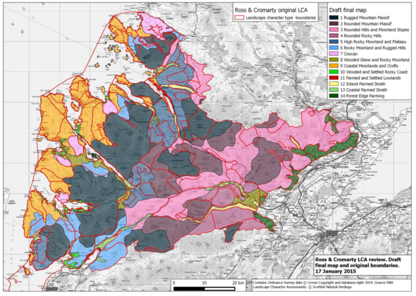
Map of e) Ross & Cromarty
Northern Inner Moray Firth
The 1998 Inner Moray Firth Landscape Character Assessment report was extensively reviewed together with the adjacent Ross & Cromarty study area. This was undertaken by a landscape consultant, funded by SNH and FCS, in consultation with The Highland Council. The revisions addressed the following aspects:
- Even-out the grain of the LCTs in the 1998 LCA report and make it more consistent with the national suite.
- Land use based LCTs simplified and incorporated with wider LCTs where relevant.
- Crofting areas checked against Historic Land use Assessment mapping; some additional areas identified around Strathpeffer to Dingwall and Knockfarrel.
- Cross-boundary integration with Ross & Cromarty, Caithness & Sutherland and Inverness.
f) Skye & Lochalsh
The 1996 Landscape Character Assessment report was extensively reviewed. This was undertaken by a landscape consultant, funded by SNH and FCS, in consultation with The Highland Council. The revisions addressed the following aspects:
- LCTs simplified and the grain broadened, especially in coastal and moorland/peatland areas.
- Land use based LCTs incorporated in relevant LCTs, e.g. Coniferous Woodland, Broadleaf or Mixed Woodland, Peat Hag, Reservoir.
- Urban category removed – there are no settlements over the 25,000 population threshold.
- Marine LCTs removed, e.g. Kyles, Firths and Sounds.
Main changes were:
- Settlement was extended to include associated farmed land, to create a new LCT “Farmed and Settled Lowlands – Skye and Lochalsh”.
- Rocky Undulating Plateau incorporated into “Rugged Massif – Skye & Lochalsh” or other appropriate LCT.
- Rugged Massif at lower elevations is divided into “Rocky Moorland – Skye & Lochalsh” (LCT in the original LCA), or “Rugged Coastal Hills – Skye & Lochalsh” (LCT in Lochaber LCA).
- Most Rugged Massif areas on Skye are redefined as “Stepped Moorland”, “Rocky Moorland – Skye & Lochalsh” or included as foothills of other mountain LCTs.
- Smooth Moorland is subdivided into “Low Smooth Moorland” and “Upland Sloping Moorland”.
- Rounded Hills and Angular Mountain Range on Skye extended to include their foot-slopes and foothills (originally mapped as Rugged Massif). They have been re-named as “Smooth Mountain Range” and “Angular Mountain Range – Skye & Lochalsh” respectively.
- “Interlocking Sweeping Peaks – Skye & Lochalsh” has been extended northwards into Rugged Massif north of Glen Shiel and another area of Rugged Massif is changed to Interlocking Sweeping Peaks – Skye & Lochalsh”, adjacent to the inner part of Loch Hourn. Two areas of Interlocking Sweeping Peaks have been reclassified as “Rugged Massif – Skye & Lochalsh” around the outer part of Loch Hourn.
- Rocky Moorland on Rona and north Raasay has been reclassified as “Cnocan – Skye & Lochalsh” (reflecting similar LCTs in Ross & Cromarty and Caithness & Sutherland LCA).
- A new LCT “Landslide Edge and Undulating Ridge” incorporates the original Landslide Edge and High Basalt Hills LCTs to the west.
- A new LCT of “Stepped Hills” is identified, centred on Macleod’s Tables and the Duirinish peninsula.
- Marine LCTs have been removed, with the terrestrial areas included in these assigned to an appropriate LCT.
See map below for boundary differences.
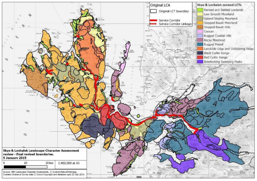
Map of f) Skye & Lochalsh
12. Loch Lomond and the Trossachs
The 2005 and 2009 Landscape Character Assessment reports were extensively reviewed. This was undertaken by a landscape consultant, funded by SNH and FCS, in consultation with the National Park Authority. The revisions addressed the following aspects:
1. Resolution of cross-boundary issues
The principal changes are to:
- Redefine the Hills LCT in the Cowal and the Luss Hills area (covering lower and generally smoother hills predominantly 500-700m high) as “Steep Ridges and Hills”. The higher peaks in the north and north-east of the National Park were renamed as “Highland Summits” to match the approach taken in adjacent LCA studies.
- Smaller and largely unsettled Upland Glens were incorporated into relevant upland LCTs to accord with the approach taken in adjacent LCA reports.
- Glen Sides along the sea lochs of Cowal in the west of the Park were incorporated into and redefined as “Steep Ridges and Hills” LCT.
- The Sea Loch Foreshores and Sea Loch Shore Fringes along the sea lochs of Cowal, together with areas of settlement, were combined to form a new LCT called “Settled Coastal Fringe”.
- The area of Moorland in the Rosneath/Helensburgh area was redefined as “Open Ridgeland – Glasgow & Clyde Valley” to be consistent with larger areas of similar LCT in Glasgow & Clyde Valley and Argyll & Firth of Clyde.
- The Moorland LCT (renamed “Plateau Moor and Forest – Loch Lomond & the Trossachs”) was extended into the Loch Ruskie and Lennieston Muir area south of Callander (this is classified as L14 – Forth and Teith Valley Fringe in the Stirlingshire 2012 LCA). The different permutations of this LCT (open, forest, farmed) were combined into a single LCT.
- The Natural and Restored Moss and the Lowland Loch, Loch Islands and Loch Shore Fringes in the Lake of Menteith area were combined into a single LCT called “Lowland Peatlands and Loch Basin”. This extends into Stirlingshire at Flanders Moss.
2. Changes to classification within Loch Lomond and Trossachs
The following changes to the classification of landscape character within the 2009 Loch Lomond and Trossachs LCA report:
- Incorporate smaller glens (narrow side glens and those which are largely unsettled) presently defined as Upland Glens into adjacent upland LCTs. Retain larger glens as “Upland Glen – Loch Lomond & the Trossachs” and omit classifications based on land cover such as forested/wooded/farmed. Combine Upland Glen Lochs (which occur only in larger glens) with “Upland Glen – Loch Lomond & the Trossachs” LCT.
- Combine Glen Sides and Strath and Glen Floors into a single LCT called “Straths and Glens” (omitting classifications based on landcover such as forestry/woodland/farming). Where lochs are a major feature within broader valleys, combine the Strath and Glen Lochs and Loch Shore Fringes LCTs with Strath and Glen Floors and Glen Sides into a new LCT called “Straths and Glens with Lochs” (eg. Loch Eck, Loch Earn, Loch Venachar/Loch Katrine).
- Combine the Open/Forested/Wooded Upland Ridges into a single LCT named “Rolling Forested Plateaux”.
- Combine the Open/Forested/Farmed Parallel Ridges into a single LCT called “Parallel Ridges – Loch Lomond & the Trossachs” noting the differences in land cover and character in the revised description.
- Incorporate a small area of Moorland LCT to the north-west of Callander into the adjacent “Highland Summits” LCT. Although this area of hill land is lower than the high mountain peaks, it lies to the north of the “Parallel Ridges – Loch Lomond & the Trossachs” LCT around Callander Craigs and is separated from the “Lowland Hills – Central” (defined in the Central and Stirlingshire LCA studies) by the Keltie Water valley, a robust boundary.
- Redefine lower Loch Lomond as a new LCT named “Lowland Loch Basin – Loch Lomond & the Trossachs”. This includes the Loch Shore Fringes, Loch Islands, River Valley Farmland with Estates, Strath and Glen Floors and Glen Sides LCTs around the loch. Upper Loch Lomond is classified as “Glens and Strath with Loch”.
3. Other changes
- The Highland/Lowland/“transitional” aspects retained as far as is consistent with the national suite, at the request of the LLTNPA.
- The Loch Lomond islands (including those defined as Parallel Ridges) retained as a separate LCT – “Lowland Loch Basin Islands”. The islands are also noted in the revised descriptions for the new LCT “Lowland Loch Basin – Loch Lomond & the Trossachs” and the “Parallel Ridges – Loch Lomond & the Trossachs” LCT.
13. Lothians
General Changes
- Boundaries of urban areas updated.
- Uplands sub-divided into separate LCTS – the Moorfoot Plateau and Lammermuir Plateau are reclassified “Plateau Moorland – Lothians”, Fala Moor is “Plateau Grassland – Lothians”, and the Pentland Hills are “Upland Hills – Lothians”.
- Coast sub-divided into separate LCTs – Dunbar Plain becomes “Coastal Margins – Lothians”, the North Berwick Plain is reduced in extent and called “Coastal Terrace – Lothians”, the Musselburgh/Prestonpans Fringe is now “Settled Coastal Farmland”, and the Linlithgow/Queensferry Farmlands and are now “Coastal Farmland – Lothians”.
- New LCT “Lowland River Corridors - Lothian” identified along incised stretches of the River Almond/Linhouse Water and River Avon.
East Lothian
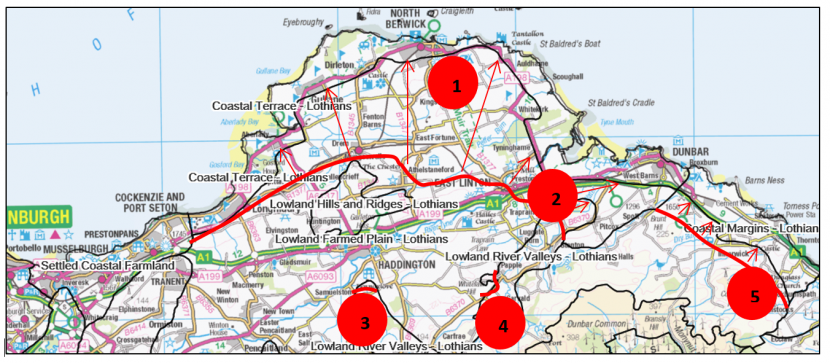
Map of East Lothian
Click for a full description
1. Lowland Plain (now “Lowland Farmed Plain – Lothians”) extended northwards.
2. Beil Water “Lowland River Valleys – Lothians” extended eastwards.
3. “Lowland River Valley – Lothians” extended northwards and westwards from Gifford/Coulston Waters.
4. Side tributary valley included in “Lowland River Valleys – Lothians” at Whittinghame Water.
5. Eastern edge of “Upland Fringes – Lothians” extended eastwards towards coast.
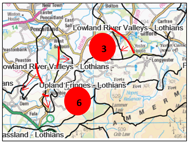
Map of East Lothian
Click for a full description
3. “Lowland River Valley – Lothians” extended northwards and westwards from Gifford/Coulston Waters.
6. Tributaries of Humbie Water added to “Lowland River Valleys – Lothians”.
Edinburgh City
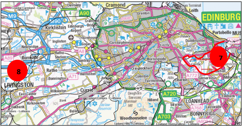
Map of Edinburgh City
Click for a full description
7. Extent of Urban area increased to take account of new development areas of Newcraighall and Newhailes.
8. New LCT “Lowland River Corridors - Lothians” identified along the River Almond.
Midlothian
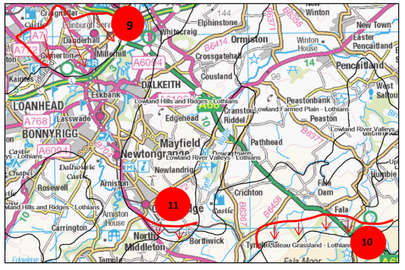
Map of Midlothian
Click for a full description
9. Shawfair/Danderhall areas redefined as “Urban” due to major development proposed/underway.
10.”Upland Fringes – Lothians” boundary moved southwards at Fala Moor.
11. Slight realignment of “Lowland Hills and Ridges – Lothians” LCT at southern end of Mayfield/Tranent ridge.
West Lothian
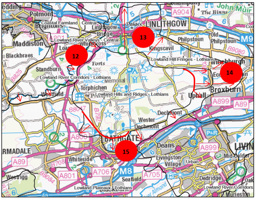
Map of West Lothian
Click for a full description
12. New “Lowland River Corridor - Lothians” LCT along West Lothian boundary following River Avon.
13. New “Lowland Hill Fringes – Lothians” LCT added around the north, east and south-west of “Lowland Hills and Ridges- Lothians”.
14. “Lowland Hills and Ridges – Lothians” extended to the east.
15. “Lowland Hills and Ridges – Lothians” extended in Bathgate area.
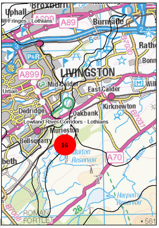
Map of West Lothian
Click for a full description
16. New “Lowland River Corridor - Lothians” LCT east of Livingston, following the Linhouse Water.
14. Moray and Nairn
The 1998 Landscape Character Assessment report was extensively reviewed, along with the southern Inner Moray Firth LCA. This was undertaken by a landscape consultant, funded by SNH and FCS, in consultation with the Moray Council.
An area to the south of Moray, north of the current Cairngorms National Park boundary (shown with red hatching on the map below) was originally covered by the 1996 Cairngorms LCA. This area was not included in the consultant’s review, and was subsequently examined by SNH landscape advisors who drew up the LCT boundaries and included the areas in the relevant Moray and Nairn LCT descriptions.
The revisions addressed the following broad aspects:
- Several minor amendments made to LCT boundaries - shown on the map below.
The large area of “Upland Farmland” was subdivided into four new LCTs – “Low Forested Hills”, “Farmed and Wooded River Valleys”, and “Upland Farmed Valleys” – as well an outlying area (Ben Aigan) of “Open Upland”. This better reflects the complex topography of this area where low hills and valleys interweave, but the grain of 1:50,000 still results in some combining of higher ground with ‘valley’ LCTs.
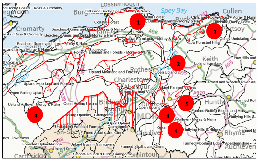
Map of Moray and Nairn
Click for a full description
1. Elgin redefined as a separate “Urban” area.
2. Ben Aigan redefined as an outlying area of “Open Upland”.
3. Part of Upland Farmland subdivided to create separate area of “Low Forested Hills”.
4. Three valleys in upland areas identified as separate “Upland Valleys – Moray and Nairn”.
5. Part of Upland Farmland redefined as “Upland Farmed Valleys”.
15. Orkney
General changes
- Urban category removed – there are no settlements over the 25,000 population threshold.
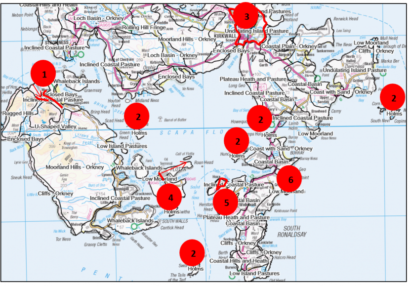
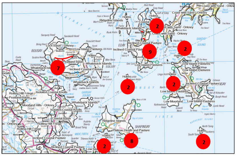
Map of Orkney
Click for a full description
1. Area of Rolling Hill Fringe redefined as “Plateau Heath and Pasture”.
2. Larger of the smaller islands defined as “Holms”.
3. Original Kirkwall Urban and Rural Development redefined as “Undulating Island Pasture” and “Coastal Basin”.
4. Flotta Urban and Rural Development and Low Island Pastures redefined as “Low Moorland”.
5. Small area of Plateau Heaths redefined to link to adjacent “Inclined Coastal Pasture” on South Ronaldsay.
6. Area of Whaleback Island redefined as “Inclined Coastal Pasture” on Burray.
Map of Orkney
Click for a full description
2. Larger of small islands defined as “Holms”.
7. “Peatland Basin” boundary moved northwards on Rousay.
8.”Plateau Heaths and Pasture” enlarged on Shapinsay.
9. Area of Peatland Basin redefined as “Inclined Coastal Pastures” on Eday.
16. Outer Hebrides ( was originally Western Isles LCA)
- Minor realignments of crofting areas using the benefits of better mapping.
- “Urban” category removed as there are no settlements over the 25,000 population threshold.
- Renaming of LCTS, in particular crofting areas, which used to be Crofting 1, 2 3 and 4 as “Gently Sloping Crofting”, “Linear Crofting”, “Dispersed Crofting” and “Low-Lying Crofting”.
17. Shetland
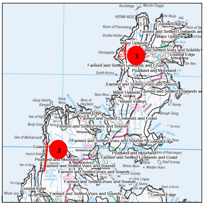
Map of Shetland
Click for a full description
1. Area of Farmed and Settled Lowlands and Coast redefined as “Major Uplands”.
2. Area of Farmed and Settled Lowlands and Coast redefined as “Peatland and Moorland”.
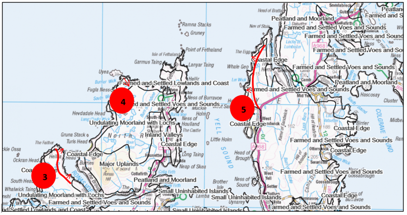
Map of Shetland
Click for a full description
3. Area of Farmed and Settled Voes and Sounds redefined as “Undulating Moorland with Lochs”.
4. Area of Undulating Moorland with Lochs redefined as “Farmed and Settled Lowlands and Coast”.
5. Area of Farmed and Settled Lowlands and Coast redefined as “Peatland and Moorland”.
18. Tayside
Perth and Kinross
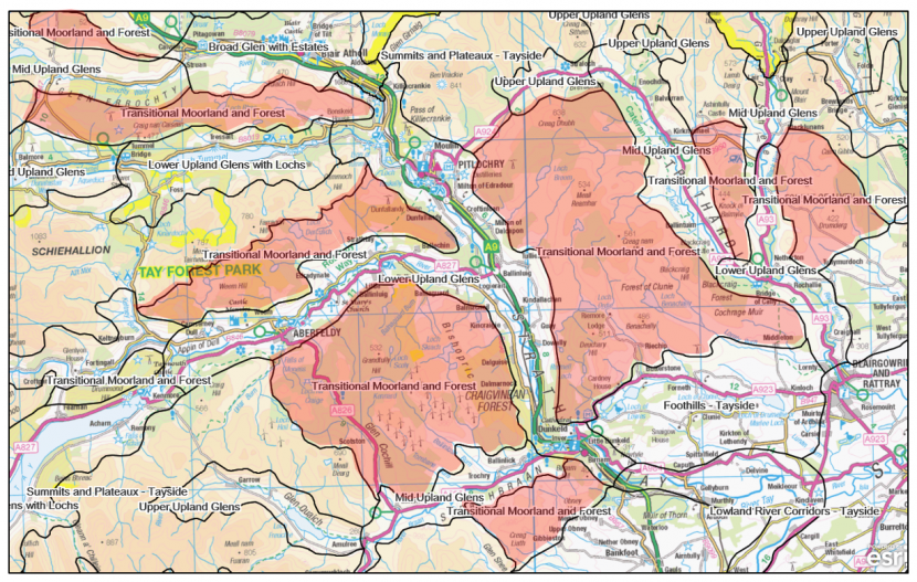
Areas shown in red on map below – parts of Summits and Plateaux – Tayside have been subdivided to create areas of new “Transitional Moorland and Forest” LCT on lower, more wooded areas.
Map of Perth and Kinross
Click for a full description
Areas shown in red on map – parts of Summits and Plateaux – Tayside have been subdivided to create areas of new “Transitional Moorland and Forest” LCT on lower, more wooded areas.
Angus
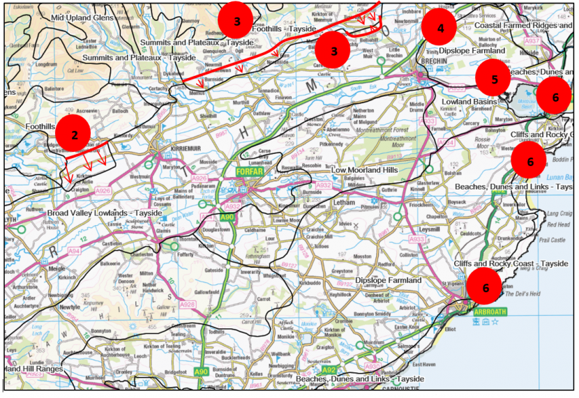
Map of Angus
Click for a full description
2. Realignment of “Foothills – Tayside” boundary near Kirkton of Airlie.
3. Realignment of “Foothills – Tayside” boundary north of Forfar.
4. “Broad Valley Lowland” redefined as “Dipslope Farmland”.
5. North and south boundaries of “Lowland Basins” realigned.
6. Realignment of the inland boundaries of coastal LCTs.