NatureScot Research Report 1383 - Biological analyses of underwater video from monitoring and research cruises carried out from 2021 to 2023 in the Clyde Sea, Sound of Barra, Loch Carron, Loch Eriboll and off Wester Ross
Published: 2026
Author: Dr Colin G. Moore
Cite as: Dr Colin G. Moore. Biological analyses of underwater video from monitoring and research cruises carried out from 2021 to 2023 in the Clyde Sea, Sound of Barra, Loch Carron, Loch Eriboll and off Wester Ross. NatureScot Research Report 1383.
Contents
- Keywords
- Background
- Main findings
- Acknowledgements
- 1. Introduction
- 2. Methods
- 3. Results
- 4. Discussion
- 5 References
Keywords
Benthos; biotope; PMF; MPA; SAC; protected feature; Annex I; habitat; video
Background
The aim of this study was to improve knowledge of the occurrence and distribution of species and habitats of recognised conservation importance in six locations around Scotland through the analysis of seabed video and still photographic imagery collected during monitoring and research cruises undertaken from 2021 to 2023. Surveyed areas include Loch Eriboll and five locations encompassed by the Scottish Marine Protected Area (MPA) network: Clyde Sea Sill MPA, South Arran MPA, Sound of Barra SAC, Loch Carron MPA and Wester Ross MPA. This work also contributes to programmes of MPA monitoring of protected features, and of refining knowledge of the distribution of European Commission Habitats Directive Annex I habitats and Priority Marine Features (PMFs) within Scottish waters.
Main findings
- Dropdown video surveying within the Clyde Sea Sill MPA extended knowledge of the distribution of the protected feature 'circalittoral and offshore sand and coarse sediment communities’ and the PMF 'burrowed mud'. A first record of the maerl bed PMF was also recorded in the north of the MPA, although the bed was strongly dominated by dead maerl and exhibited a poorly developed epibiotic community.
- Burrowed mud was very widely recorded beyond the 40 m depth contour within the South Arran MPA, where it is a protected feature. There is some evidence for a temporal improvement in the condition of the habitat. Despite the extensive sampling of the habitat in the current 2021 survey work, there was no indication of the presence of trawl scarring within the monitoring boxes where it was found in 2015.
- Video sampling off Pladda island in the South Arran MPA considerably expanded the known extent of a flame shell bed here (a PMF), which appears to extend over an area of 40 ha, albeit in patchy form.
- Repeated diver-based monitoring of a seagrass bed site in Whiting Bay, Arran (a protected feature) revealed no marked temporal change in Zostera marina abundance, but a decline in the density of the invasive red alga Dasysiphonia japonica between 2014 and 2023.
- Several video runs in the northern channel to Lamlash Bay straddled the southern margin of a maerl bed (a protected feature) and consequently provided an improved delineation of the southern edge of the bed.
- Monitoring boxes in the Sound of Barra were found to be composed essentially of mosaics of the Annex I habitat features, bedrock reefs, subtidal sandbanks (gravelly and clean sands) and subtidal sandbanks (maerl beds), all of which were widespread, although maerl beds were infrequently recorded beyond the Sound of Barra SAC limits. The high intensity of historical video sample collection within the monitoring boxes permitted detailed analysis of temporal change in biotope distribution and maerl bed condition. A temporal change in sedimentary biotope at one location was considered to result from natural variability in such a highly hydrodynamic environment. There was no good evidence suggestive of a significant temporal change in the density of live maerl between historical records from 2015 - 2018 and the current 2023 survey.
- The 2023 Loch Carron survey was carried out in the vicinity of three flame shell beds (a protected feature of the Loch Carron MPA) impacted in 2017 by dredging. There was an indication of some temporal enhancement of byssal turf development at some locations since 2017 and there was strong evidence that one of the beds had extended beyond its 2017 limits, with the development of a well-formed, sand/turf mosaic where the habitat was previously recorded as absent, and where the seabed previously exhibited signs of dredge damage.
- A 2023 video run passing through the Sruth Lagaidh flame shell bed in Loch Broom (a protected feature of the Wester Ross MPA) indicated a precise match between the eastern and western boundary limits identified in 2017. Although an enhancement in turf thickness of the bed was previously identified between 2010 and 2017, there was no indication of a change in extent or condition of the bed between 2017 and 2023.
- Aggregations of the northern feather star (Leptometra celtica) on mixed substrata (a protected feature) were recorded on the outer and mid-loch sills of Little Loch Broom. Leptometra density was similar to historical records at these locations, but some temporal variation in distribution was noted. This was considered to be expected in such a highly motile species. The results from a 2023 diver monitoring transect through a maerl bed (a protected feature) off Badluarach in the same loch were indicative of a similar community composition to that recorded in 2010, but a decrease in live maerl cover.
- Maerl beds were also identified at several other locations within or adjacent to the Wester Ross MPA, with live maerl densities in most cases similar to those recorded by previous surveys or differing possibly as a result of spatial patchiness. A maerl bed off Rubha Dubh Ard ('Planet Rock') overlapped with a poorly developed flame shell bed. 2023 video and photo quadrat imagery from a diver monitoring transect off Tanera More revealed changes in seabed topography, substrate composition, the algal flora and a possible reduction in live maerl density since 2010. Natural change in the level of hydrodynamic activity was considered to represent a likely causative factor.
- The protected feature burrowed mud was recorded widely in the Wester Ross MPA, particularly below the 50 m depth contour. The habitat displayed similar densities of megafaunal burrowers and sea pens to those recorded during previous surveys at nearby sites.
Acknowledgements
Dr Graham Saunders is thanked for his contribution to QA of the project outputs. For the acquisition of imagery and associated survey data the author is grateful to the scientific staff and vessel crew of NatureScot, Marine Directorate and Glasgow University, and to Peter Webster (NatureScot) for project management.
1. Introduction
The present investigation involves analysis of underwater video and still imagery from eight surveys at six locations in Scottish territorial waters (Table 1). The imagery was collected from 2021 to 2023 by Marine Directorate (MD) (previously Marine Scotland Science (MSS)) and NatureScot (NS), as well as by Glasgow University on behalf of the Sustainable Inshore Fisheries Trust (SIFT) and Wildland Ltd.. The survey locations are shown in Figure 1. Five of these are encompassed within the Scottish network of marine protected areas, which includes Special Areas of Conservation (SACs) and Marine Protected Areas (MPAs). The SACs were established under the 1992 European Commission Habitats Directive and were selected for the protection of particular habitats and species (qualifying features) which are listed in Annex 1 and 2, respectively, of the Directive. The MPAs were designated in 2014 under the Marine (Scotland) Act 2010 and afford protection to a range of nationally important habitats and species (Protected Features). Imagery was obtained from the following protected areas: South Arran MPA, Clyde Sea Sill MPA, Sound of Barra SAC, Loch Carron MPA and Wester Ross MPA. Survey work was also carried out in Loch Eriboll, which does not lie within a protected area. The habitats and species constituting protected features (PFs) within the four MPAs are listed in Annex 1. The qualifying features for the Sound of Barra SAC include the Habitats Directive Annex I habitats reefs and subtidal sandbanks (for details see Annex 2), as well as the Annex II species Phoca vitulina (harbour seal).
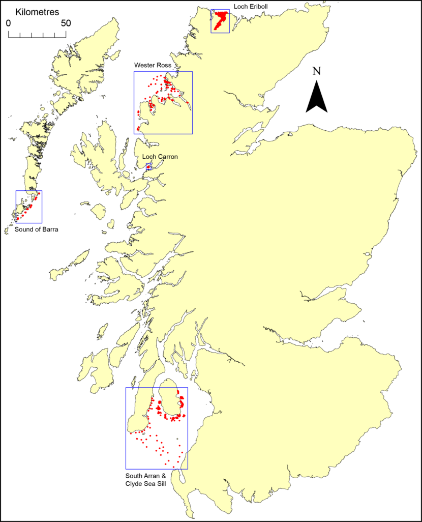
Figure 1. Distribution of survey locations (blue boxes) and sample sites (red dots).
Click for a full description
Map of Scotland with five blue boxes showing the following survey locations:
1. South Arran and Clyde Sea Sill
2. Sound of Barra
3. Loch Carron
4. Wester Ross
5. Loch Eriboll
Survey sites are shown as red dots within the location boxes. © Crown copyright and database rights [2024] Ordnance Survey 100017908.
This report contributes to a long series of underwater video analyses commissioned by NatureScot (formerly SNH) since 2009. The primary aim of these studies is to improve knowledge of the occurrence and distribution of species and habitats of recognised conservation importance through the analysis of seabed video and still photographic imagery collected during monitoring and research cruises. Where surveyed areas form part of the marine protected area network, a further objective is to contribute to monitoring the condition of habitats and species, particularly with regard to designated protected features. The current study also serves to contribute to a programme of refining the distribution of Habitats Directive Annex I habitats within Scottish SACs and the distribution of Protected Features within MPAs.
The conservation importance of features found in this report has been assessed through consideration of a number of legislative drivers. These include the presence of qualifying habitats within the SAC and protected features in the MPAs, and the presence of Scottish Priority Marine Features (PMFs) (NatureScot, 2024). Cognisance has also been taken of other published importance measures.
2. Methods
Survey details are provided in Table 1.
| Survey name | Date | Survey type | Imagery collected | No. sites | Site prefix |
|---|---|---|---|---|---|
| 2021 NatureScot/Marine Directorate South Arran and Clyde Sea Sill benthic camera survey (cruise 1121A) | 23/08/2021 - 06/09/2021 | dropdown video | video, stills | 51 | T, D, FS, V |
| 2021 NatureScot/Marine Directorate South Arran and Clyde Sea Sill benthic camera survey (cruise 1121A) | 30/08/2021 - 04/09/2021 | stills transects | stills | 353 | ARR |
| 2023 NatureScot South Arran dive and benthic video survey | 27-31/08/2023 | dive | video, quadrat stills | 7 | SAR |
| 2023 NatureScot South Arran dive and benthic video survey | 29/08/2023 - 01/09/2023 | dropdown video | video | 9 | LBN, LBS |
| 2023 NatureScot/Marine Directorate Sound of Barra benthic camera survey (cruise 0523A) | 18/04/2023 - 01/05/2023 | dropdown video | video, stills | 26 | S0-S10 |
| 2023 NatureScot/Marine Directorate Loch Carron benthic camera survey (cruise 0523A) | 22/04/2023 | dropdown video | video, stills | 9 | LC_ |
| 2023 NatureScot/Marine Directorate Wester Ross benthic camera survey (cruise 0523A) | 17-26/04/2023 | dropdown video | video, stills | 22 | W0 |
| 2023 NatureScot/Marine Directorate Wester Ross benthic camera survey (cruise 0623A) | 03-10/05/2023 | dropdown video | video, stills | 43 | WR |
| 2023 NatureScot Wester Ross dive and benthic video survey | 27/06/2023 | dropdown video | video | 13 | WER_DDV |
| 2023 NatureScot Wester Ross dive and benthic video survey | 25-28/06/2023 | dive | video, quadrat stills | 6 | WER |
| 2021 Sustainable Inshore Fisheries Trust/Wildland Loch Eriboll benthic camera survey | 04-28/08/2021 | stereo baited remote underwater video | video | 217 | W |
In terms of methodology the surveys can be divided into five categories.
1) Five of the video surveys were carried out during MD/NS cruises on MRV Alba na Mara to the Clyde Sea (South Arran and Clyde Sea Sill), Sound of Barra, Loch Carron and Wester Ross. Video footage was obtained from dropdown video drifts with the camera frame carrying a laser scaling system and a digital stills camera permitting photographs to be taken at intervals (generally of around one minute). A high-definition video camera was employed in combination with a lower resolution ‘navigation’ camera, with the latter displaying on overlay of time, position and depth data. Vessel track data with a frequency of c.1 Hz were also available, as were positional data for the stills.
2) A digital stills-only survey was performed during cruise 1121A to South Arran within six monitoring boxes which form part of a BACI (Before-After Control-Impact) designed monitoring program. At each survey site five vertically oriented stills of the seabed were taken at approximately 12 second intervals as the vessel drifted. No depth data were available.
3) Dropdown video drift surveys were carried out by NatureScot in the South Arran MPA from the vessel RV COAST and in the Wester Ross MPA from the RIB Aphrodite. The camera frame carried a high-definition video camera and a low definition one, the latter supplied with an overlay of time, position and depth. Vessel track data with a low frequency of c.0.04 Hz was available for Arran but none for Wester Ross.
4) Dive surveys were undertaken by NatureScot in the South Arran and Wester Ross MPAs. These included examination of several sites where historical survey data were available for comparison. Video footage was collected by high definition camera within a band approximately 4 m wide along a permanently marked 25 m long transect. Along each transect seabed stills were taken at 20 random locations within a 50 x 50 cm quadrat.
5) High-definition video footage was available from a SIFT/Wildland Ltd. survey of Loch Eriboll. This involved the deployment of static high-definition video cameras in the form of SBRUV units (Stereo Baited Remote Underwater Video). At each site video imagery was collected for at least 50 minutes, although only 15 second clips from one of the pair of cameras were available for the current analysis.
The video and still imagery was used to describe the nature of the seabed in terms of the physical structure and the species assemblages. Species present were, as far as possible, identified and quantified using the semi-quantitative MNCR SACFOR scale (Hiscock, 1996). Biotopes were allocated based on the physical and biological attributes (Connor et al., 2004). Video runs traversing a sequence of habitats were split into corresponding segments, with the transition points recorded using the time, position and depth where the data were available. Video segments, as well as homogeneous, unsegmented runs, are regarded as video samples. Segmentation of runs was not practicable in the case of mosaics of biotopes, in which case all biotopes observed were simply listed. Video samples were classified according to the Habitats Directive Annex I habitats present. The presence of protected features was recorded for all video samples within MPAs and the presence of PMFs for all video samples. At sites where only stills were available (i.e. the South Arran BACI survey) the imagery was analysed in the same way as the video sites, with consecutive images at a site being grouped and described according to the assigned biotope.
Maerl represents an important habitat and protected feature in several of the locations surveyed in this study. There is no universally agreed conception of what constitutes a maerl bed biotope and this represents a complicating factor when examining temporal habitat change or making cross-study comparisons, particularly where substrate composition detail is lacking.
Maerl beds have been defined by Scottish Natural Heritage (2018) as follows:
"Maerl beds are defined by the presence of a complex 3D structure, created by accumulations of maerl pieces. Depending on environmental conditions, beds can form as continuous carpets, patches of dense maerl on other sediments, or have a linear appearance, following the troughs or ridges of sediment waves on the seabed. Accumulations of maerl are considered a bed where there is at least 20% coverage of dead or live maerl thalli. The 20% cover of maerl substrates has to extend over an area of at least 5 m x 5 m (whether continuous or in discrete patches/rows). Areas of the seabed where the substrate is made up of broken maerl gravel may also be considered maerl beds, albeit degraded ones, when there is at least 5% cover of live maerl material >1 cm in size."
This definition has been broadly adopted for the current study but with some modification. The minimum coverage of maerl has been set at 20% cover by maerl thalli greater than 1 cm in length (whether dead or alive). A substrate of comminuted gravel, albeit with 5% live maerl cover, is considered to possibly represent a markedly different habitat for an associated community and hence, although it might be considered a degraded maerl bed, the ascription of any existing maerl biotope may not be appropriate. In fact such substrates were not encountered during the survey work considered here.
All depths were converted to depth below chart datum employing TotalTide software (Admiralty, Taunton) to determine tidal rise at the most appropriate secondary port.
In the figures of this report for clarity the positions of biotope records have generally been plotted using biotope symbols marking the midpoint of the start and end of the sample, together with the simplified track using a straight line between start and end points. Short track lines may be occluded by biotope symbols. In an accompanying GIS file the detailed vessel track data for each run has been segmented into biotopes, Annex 1 habitats, protected features and PMFs, and this form of display is employed in figures of the current report only where it provides additional useful detail, such as in delimiting the margins of protected feature habitats. Many of the figures in the report include identification labels for the video runs, although the video run may be split into segments or samples representing different biotopes. The label is placed close to the start of the run.
3. Results
Detailed results including physical and biological descriptions of all habitats recorded along video and still photo runs, as well as the identification of features of conservation importance, are provided in Annex 3. Biotope codes are given in bold throughout the report, with bold italics used for PMF biotope codes and species names within the results section.
3.1 Clyde Sea (Clyde Sea Sill and South Arran)
Two surveys were carried out in this region, both of which incorporated two major components. A 2021 NS/MD survey included dropdown video and still photo transects, while a 2023 NS survey employed dropdown video and diver video transects (Table 1, Figure 2). Most sample sites were located within the Clyde Sea Sill MPA and within a set of monitoring boxes largely confined to the South Arran MPA (Figure 2). The results will be described regionally, employing the sequence of geographical areas depicted in Figure 2.

Figure 2. Distribution of sample sites for the surveys carried out in the Clyde Sea.
Click for a full description
Map of southern region of the Clyde Sea showing the location of sample sites for the surveys using different coloured dots:
1. 2021 NS/MD dropdown video - green
2. 2021 NS/MD BACI stills - orange
3. 2023 NS dropdown video - red
4. 2023 NS dive video - black
Also shown is the location of the video monitoring boxes in green: D1, D3, D4, D5, D6, FS, T1, T2, T3, T4, the BACI stills monitoring boxes in orange: Arr01 - 04, Arr06 - 08 and Arr10 - 11, the South Arran and Clyde Sea Sill MPAs in grey, and the following regions used in the description of results (black rectangles with name labels):
1. Clyde Sea sill
2. Kilbrannan Sound
3. Arran southern coastline
4. Holy Island
5. Brodick Bay
The Clyde Sea Sill and South Arran MPAs are shown in grey, except for that part of the South Arran MPA where demersal trawling by vessels up to 120 tonnes is permitted (in violet). © Crown copyright and database rights [2024] Ordnance Survey 100017908.
3.1.1 Clyde Sea Sill (Figure 3)
Biotope records for the Clyde Sea Sill area show a general pattern of mud and sandy mud habitats to the south-east, mostly supporting fairly high densities of Nephrops norvegicus (SS.SMu.CFiMu.SpnMeg), fine sand and muddy sand in the centre of the sill (SS.SSa.CFiSa and SS.SSa.CMuSa) and coarse sediments in the area of elevated currents off Kintyre. In this region gravelly sediments with stones supporting Flustra foliacea were found to be widespread (SS.SMx.CMx.FluHyd), as well as brittlestar beds (CR.MCR.EcCr.FaAlCr.Bri), with a single maerl bed of predominantly dead maerl material (SS.SMp.Mrl).
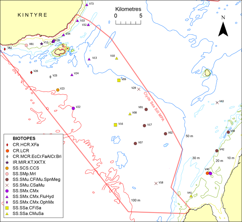
Figure 3. Distribution of biotope records on the Clyde Sea Sill and in adjacent waters.
Click for a full description
Map showing distribution of biotope records in the area of the Clyde Sea Sill and adjacent waters using symbols differing in shape and colour to denote the different biotopes. Also shown are the 10 m, 20 m, 30 m, 50 m and 100 m depth contours and the limits of the Clyde Sea Sill MPA (dark pink line). © Crown copyright and database rights [2024] Ordnance Survey 100017908. Bathymetry © Crown Copyright, 2020. All rights reserved. Licence No. EK001-20140401. Not to be used for navigation.
3.1.2 Kilbrannan Sound (Figure 4)
The predominant habitat recorded in Kilbrannan Sound and its southern approaches was burrowed mud (SS.SMu.CFiMu.SpnMeg), which was widely present below the 50 m depth contour and generally supported moderately dense burrows of Nephrops norvegicus and Calocaris macandreae and at some sites sparse sea pens in the form of Virgularia mirabilis and Pennatula phosphorea. It was clearly the dominant habitat in monitoring boxes Arr08, Arr11 and T3, although poor visibility resulting from sediment disturbance by the camera frame precluded its identification at several of the deeper sites in box Arr08. The habitat was also recorded in shallower depths, up to around the 30 m contour, but megafaunal burrows were sparser and the biotope was transitional between SS.SMu.CFiMu.SpnMeg and SS.CMu.CSaMu. The other principal habitat recorded in this area, particularly off the Kintyre coastline was mixed gravelly sediments (SS.SMx.CMx), locally with dense Synarachnactis (=Cerianthus) lloydii (SS.SMx.CMx.ClloMx) and at several locations with silted cobbles and boulders supporting hydroid turfs (CR.LCR.BrAs).
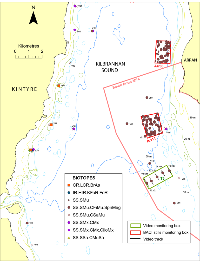
Figure 4. Distribution of biotope records in Kilbrannan Sound and its southern approaches (Clyde Sea).
Click for a full description
Map showing distribution of biotope records in the area of Kilbrannan Sound and its southern approaches using symbols differing in shape and colour to denote the different biotopes. Also shown are the 10 m, 20 m, 30 m, 50 m and 100 m depth contours, the video monitoring boxes (in green), BACI stills monitoring boxes (in red) and the boundary of the South Arran MPA (dark pink line). Video tracks are shown as black lines with run labels, although for short runs the track will be occluded by the biotope symbol. © Crown copyright and database rights [2024] Ordnance Survey 100017908. Bathymetry © Crown Copyright, 2020. All rights reserved. Licence No. EK001-20140401. Not to be used for navigation.
3.1.3 Arran southern coastline (Figures 5, 6)
Most of the sample sites off the southern coastline of Arran were in shallower waters than the Kilbrannan Sound survey sites and consequently represented a different suite of habitats, although burrowed mud (SS.SMu.CFiMu.SpnMeg) was recorded in the deeper areas beyond about 40 m and transitioned into sandy mud or cohesive muddy sand (SS.SMu.CSaMu) with decreasing depth in monitoring boxes T2 and Arr01 (Figure 5). Megafaunal burrow density was generally light to moderate, although dense burrows of Nephrops norvegicus and Calocaris macandreae were observed in the deeper, softer muds in box T4 at depths of 110 - 125 m. Within box D4, which spanned a depth range of 16 - 34 m, the inshore region included megarippled coarse sediment (SS.SCS.CCS) interrupted by areas of stones on coarse sediment supporting Saccharina latissima and red algae (SS.SMp.KSwSS.SlatR.CbPb) or just a dense red algal turf (IR.HIR.KFaR.FoR). This gave way with increasing depth to predominantly mixed substrates of muddy sand with stones (SS.SMx.CMx) interrupted by patches of muddy sand (SS.SSa.CMuSa) and silted boulders and cobbles supporting hydroid turfs (CR.LCR.BrAs.AntAsH). Similar areas of muddy sand and mixed substrates were recorded in the deeper region of box D6, but these were replaced in shallower water by a belt of megarippled dead maerl with frequent live maerl in a belt at least 1.5 km long at a depth of 11 - 20 m (SS.SMp.Mrl).

Figure 5. Distribution of biotope records along the southern coastline of Arran.
Click for a full description
Map showing distribution of biotope records off the southern coastline of Arran using symbols differing in shape and colour to denote the different biotopes. Also shown are the 10 m, 20 m, 30 m, 50 m and 100m depth contours, the video monitoring boxes (in green), BACI stills monitoring boxes (in red) and the boundary of the South Arran MPA (dark pink line). Video tracks are shown as black lines with run labels, although for short runs the track will be occluded by the biotope symbol. © Crown copyright and database rights [2024] Ordnance Survey 100017908. Bathymetry © Crown Copyright, 2020. All rights reserved. Licence No. EK001-20140401. Not to be used for navigation.
Monitoring box FS is subsumed within the Arr07 box, both of which largely lie between the 20 m and 30 m depth contours and contain a flame shell bed (SS.SMx.IMx.Lim) (Figure 6). Delineation of the bed boundary suggests the bed extends over an area of 40 ha, although within this area it is patchy and accompanied by other habitats, particularly bedrock, boulders and cobbles supporting a dense red algal turf (IR.HIR.KFaR.FoR) or hydroid turf (CR.HCR.XFa). Within the bed bysally-bound shells, gravel, pebbles and cobbles reach 50% cover locally but mostly occur as scattered patches with 10 - 20% cover. However, the bysally-bound nature of the substrate is highly uncertain for several of the records, in part due to poor image quality, with confirmation of the bed extent requiring further diver-based observations. The bed and adjacent mixed substrates in places supported dense Ophiocomina nigra and Ophiothrix fragilis (SS.SMx.CMx.OphMx).
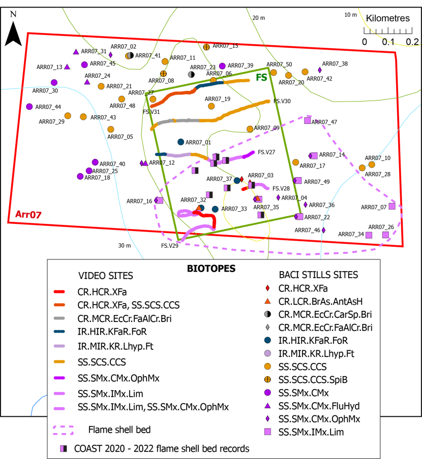
Figure 6. Distribution of biotope records within monitoring boxes Arr07 and FS off the southern coast of Arran.
Click for a full description
Map showing distribution of biotope records within video monitoring box FS and BACI stills monitoring box Arr07. Also shown are 2020 - 2022 flame shell bed records from COAST dives (Community of Arran Seabed Trust) Biotopes at the stills sites are denoted by symbols differing in shape and colour to denote the different biotopes with attached site labels. Biotopes along video runs are denoted by coloration of the vessel tracks with attached run labels. An indication of the extent of a flame shell bed, based on the biotope mapping, is presented as a dashed, light purple line. Also shown are the 10 m, 20 m and 30 m depth contours and the boundary of box FS (in green) and box Arr07 (in red). © Crown copyright and database rights [2024] Ordnance Survey 100017908. Bathymetry © Crown Copyright, 2020. All rights reserved. Licence No. EK001-20140401. Not to be used for navigation.
The northern regions of boxes Arr07 and FS were floored with predominantly coarse sediment of sand, gravel and pebbles (SS.SCS.CCS) and mixed gravel and muddy sand with Chaetopterus variopedatus (SS.SMx.CMx), and locally with stones supporting hydroids and Flustra foliacea (SS.SMx.CMx.FluHyd).
3.1.4 Holy Island (Figures 7, 8)
Sample sites off Holy Island lie principally within video monitoring boxes to the north (D5) and south (D1) of the island and BACI monitoring box Arr04 to the east (Figure 7). A bed of dead maerl (20 - 60% cover) was recorded at three sites in the shallower region of box D1 at depths of 11 - 22 m, with live maerl thalli constituting <1% cover (SS.SMp.Mrl). In deeper waters (20 - 30 m) the dominant habitat was gravelly sand (SS.SMx.CMx), locally with dense Ophiocomina nigra (SS.SMx.CMx.OphMx) or with dense Synarachnactis lloydii (SS.SMx.CMx.ClloMx), as well as Nemertesia antennina (SS.SMx.CMx.ClloMx.Nem). A similar habitat of mixed gravelly sand with stones and shells supporting Nemertesia spp. was recorded in the nearby southern entrance to Lamlash Bay, although S. lloydii was not observed (SS.SMx.CMx).
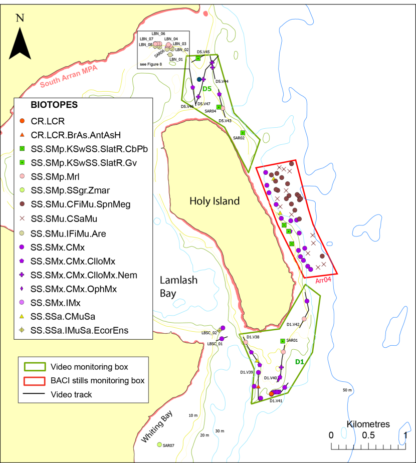
Figure 7. Distribution of biotope records around Holy Island, Arran.
Click for a full description
Map showing distribution of biotope records around Holy Island, Arran using symbols differing in shape and colour to denote the different biotopes. Greater detail within the area of a black rectangle in the north channel into Lamlash Bay is provided in Figure 8. Also shown are the 10 m, 20 m, 30 m and 50 m depth contours, the video monitoring boxes (in green), BACI stills monitoring boxes (in red) and the boundary of the South Arran MPA (dark pink line). The video track is shown as a black line with run label, although for short runs the track will be occluded by the biotope symbol. © Crown copyright and database rights [2024] Ordnance Survey 100017908. Bathymetry © Crown Copyright, 2020. All rights reserved. Licence No. EK001-20140401. Not to be used for navigation.
There was a depth related gradient of biotopes observed in box Arr04. Gravel and pebbles along the 10 m depth contour supported Saccharina latissima and a red algal turf (SS.SMp.KSwSS.SlatR.CbPb). Between the 10 m and 30 m depth contours mixed gravelly, pebbly sands predominated, often supporting Chaetopterus variopedatus and Omalosecosa ramulosa (SS.SMx.CMx). From the 30 m to the 50 m depth contours the sediment was composed of sandy mud or cohesive muddy sand with a light to moderate density of megafaunal burrows (SS.SMu.CFiMu.SpnMeg) or the presence of only sparse or no burrows, but generally C. variopedatus (SS.SMu.CSaMu).
Box D5 encloses an area of shallow water (mostly 6 - 20 m) which extends to the north onto the sill at the northern entrance to Lamlash Bay. Mostly gravel sediments were recorded in the shallower areas, with a red algal turf and Saccharina latissima (SS.SMp.KSwSS.SlatR.Gv). Some of the gravel at these sites was comminuted maerl, but at a further site larger, dead thalli reached 30%, although live thalli covered <1% of the seabed (SS.SMp.Mrl). In deeper water gravelly sands prevailed supporting Synarachnactis lloydii (SS.SMx.CMx.ClloMx), accompanied in places by Nemertesia spp. on stones and shells (SS.SMx.CMx.ClloMx.Nem).
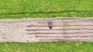
The 2023 dive survey included one site in Whiting Bay, SAR07, 2 km south-west of Holy Island. The transect traversed a moderately dense eelgrass bed at 5 m depth, with a sediment of fine sand supporting abundant Zostera marina and common Ascidiella aspersa (SS.SMp.SSgr.Zmar).
Most of the Arran sample sites were examined in 2021, but seven video and one dive site on the Lamlash Bay northern entrance sill were surveyed in 2023 (Figure 8). Most of these runs straddled the southern margin of a maerl bed (SS.SMp.Mrl). The western runs (LBN_06 - LBN_08) barely extended onto the maerl bed, with live maerl coverage around 20%, whereas penetration into the bed was greater for most of the eastern runs, traversing a rich maerl habitat of 60 - 80 % cover over a depth range of 6 - 12 m. The maerl was bound by a dense filamentous red algal turf. With increasing depth to the south the maerl bed transitioned to a mixed muddy sand substrate with shells and pebbles (SS.SMx.IMx), followed by muddy sand formed into dense Arenicola mounds at 11 - 18 m (SS.SMu.IFiMu.Are).
Figure 8. Detail of biotope records in the north channel to Lamlash Bay.
Click for a full description
Map showing distribution of biotope records within the box shown in Figure 7 in the north channel into Lamlash Bay. Biotopes are indicated by coloration of the vessel tracks. Also shown are the run labels and the 10 m and 20 m depth contours. Bathymetry © Crown Copyright, 2020. All rights reserved. Licence No. EK001-20140401. Not to be used for navigation.
3.1.5 Brodick Bay (Figure 9)
Box T1 was located in an area of deep mud to the south-east of Brodick Bay with most runs exhibiting dense burrows of Calocaris macandreae, frequent to common Nephrops norvegicus, but sparse or absent Virgularia mirabilis and Pennatula phosphorea at depths of 65 - 89 m (SS.SMu.CFiMu.SpnMeg). Inshore of T1 most of the seabed of the BACI monitoring boxes Arr02 and Arr10 was floored by mud with a light to moderate density of megafaunal burrows including those of N. norvegicus (SS.SMu.CFiMu.SpnMeg), although patches of sandy mud occurred in box Arr02 where megafaunal burrows were very sparse or absent (SS.SMu.CSaMu). Box D3 was located at the north-east entrance to Brodick Bay and contained sample stations predominantly in shallow water (7 - 22 m). The substrate was predominantly a mix of gravel and sand, which over a depth range of 7 - 18 m supported a red algal turf and frequent - abundant Saccharina latissima (SS.SMp.KSwSS.SlatR.Gv, SS.SMp.KSwSS.SlatR). Where these algal components were sparse or absent the biotope SS.SMx.CMx was recognised. Several of these gravelly sites contained low abundances of live maerl (<1%) and comminuted dead maerl (up to 80%). The substrate at the deepest site in box D3 (33 - 37 m) was muddy sand supporting Arctica islandica (SS.SSa.CMuSa).
Figure 9. Distribution of biotope records off Brodick Bay, Arran.
Click for a full description
Map showing distribution of biotope records off Brodick Bay, east coast of Arran using symbols differing in shape and colour to denote the different biotopes. Also shown are the 10 m, 20 m, 30 m and 50 m depth contours, the video monitoring boxes (in green), BACI stills monitoring boxes (in red) and the boundary of the South Arran MPA (dark pink line). The video track is shown as a black line with run label, although for short runs the track will be occluded by the biotope symbol. © Crown copyright and database rights [2024] Ordnance Survey 100017908. Bathymetry © Crown Copyright, 2020. All rights reserved. Licence No. EK001-20140401. Not to be used for navigation.
3.2 Sound of Barra (Figures 10 - 19)
The distribution of video samples in the Sound of Barra and adjacent waters is shown in Figure 10. They were largely confined to the nine monitoring boxes S2 - S10.
Figure 10. Distribution of video sample sites for the Sound of Barra survey, with monitoring boxes and indications of the areas covered by Figures 37 - 39.
Click for a full description
Map of the Sound of Barra and adjacent waters showing the location of video sample sites (in blue), monitoring boxes S2 - S10 (in red; see Figures 11 - 19 for biotopes), boundary of the Sound of Barra SAC (in green) and the areas (numbered 1 to 3) mapped in Figures 37 - 39, which show the distribution of Annex I habitat records and PMF records. © Crown copyright and database rights [2024] Ordnance Survey 100017908.
Sampling in box S2 was impeded by the presence of fishing gear in the water and included a single video run, which straddled the northern boundary over a depth range of 15 - 25 m. The habitat recorded within the box was pebbly gravel with sparse maerl and other visible biota (SS.SCS.CCS). To the north-east this continued as a component of a patchwork of habitats including mainly sediment-scoured bedrock outcrops supporting in shallower water Laminaria hyperborea dominated kelp park with a dense red algal turf (IR.HIR.KSed.XKScrR), and in deeper water dense turfs of hydroids and bryozoans (CR.HCR.XFa.FluCoAs).
Figure 11. Distribution of biotope records in monitoring box S2 off the Sound of Barra.
Click for a full description
Map showing distribution of biotope records within and adjacent to monitoring box S2 (in red) off the Sound of Barra using symbols differing in shape and colour to denote the different biotopes. Also shown are the 10 m, 20 m, 30 m and 50 m depth contours and the boundary of the Sound of Barra SAC (in green). The video track is shown as a black line with run label. Bathymetry © Crown Copyright, 2020. All rights reserved. Licence No. EK001-20140401. Not to be used for navigation.
The three runs in box S3 spanned a depth range of 21 - 26 m, with extensive areas of rippled fine sand (SS.SSa.CFiSa). In the western half of the box this became interrupted by areas of megarippled coarse sediment (SS.SCS.CCS), which often contained frequent live maerl, at least locally (SS.SMp.Mrl). Interspersed along run S03_V03 were scoured bedrock outcrops supporting dense hydroid and bryozoan turfs including Flustra foliacea (CR.HCR.XFa.FluCoAs), and at least at one location abundant polyclinid ascidians (CR.HCR.XFa.FluCoAs.Paur).
Figure 12. Distribution of biotope records in monitoring box S3 off the Sound of Barra.
Click for a full description
Map showing distribution of biotope records within monitoring box S3 (in red) off the Sound of Barra using symbols differing in shape and colour to denote the different biotopes. Also shown is the 20 m depth contour. The video track is shown as a black line with run label. Bathymetry © Crown Copyright, 2020. All rights reserved. Licence No. EK001-20140401. Not to be used for navigation.
Maerl was recorded as widespread along the three runs in box S4 at depths of 23 - 26 m, and represented the dominant habitat (SS.SMp.Mrl). The substrate of coarse sand and gravel was thrown into megaripples, with live maerl often abundant in the troughs and in flatter areas. Sediment dusted bedrock outcrops were also present supporting dense faunal turfs, probably dominated by hydroids and bryozoans (CR.HCR.XFa.FluCoAs) mostly around 25 - 26 m depth and accompanied by dense red algal turfs at slightly shallower depths (mostly 23 – 25 m) (IR.HIR.KFaR.FoR).
Figure 13. Distribution of biotope records in monitoring box S4 off the Sound of Barra.
Click for a full description
Map showing distribution of biotope records within monitoring box S4 (in red) off the Sound of Barra using symbols differing in shape and colour to denote the different biotopes. Also shown is the 20 m depth contour. The video track is shown as a black line with run label. Bathymetry © Crown Copyright, 2020. All rights reserved. Licence No. EK001-20140401. Not to be used for navigation.
The maerl bed biotope (SS.SMp.Mrl) was also the dominant biotope recorded in box S5 over a depth range of 23 -28 m in areas of megarippled maerl and shell gravel, with live maerl often common in the troughs. This was interrupted by sediment-scoured bedrock outcrops with hydroid and bryozoan turfs including Flustra foliacea at depths of 24 - 26 m (CR.HCR.XFa.FluCoAs), and Laminaria hyperborea parks with red algal and faunal turfs at 21 - 27 m (IR.HIR.KSed.XKScrR).
Figure 14. Distribution of biotope records in monitoring box S5 off the Sound of Barra.
Click for a full description
Map showing distribution of biotope records within monitoring box S5 (in red) off the Sound of Barra using symbols differing in shape and colour to denote the different biotopes. Also shown is the 20 m depth contour and the boundary of the Sound of Barra SAC (in green). The video track is shown as a black line with run label. Bathymetry © Crown Copyright, 2020. All rights reserved. Licence No. EK001-20140401. Not to be used for navigation.
Megarippled maerl and shell gravel also dominated box S6 with sparse live maerl (SS.SCS.CCS), but mostly frequent live maerl concentrated in the troughs (SS.SMp.Mrl). Scoured bedrock outcrops occurred along all three video runs which spanned a narrow depth range of 25 - 27 m. The rock supported faunal turfs probably dominated by hydroids and bryozoans (CR.HCR.XFa.FluCoAs).
Figure 15. Distribution of biotope records in monitoring box S6 off the Sound of Barra.
Click for a full description
Map showing distribution of biotope records within monitoring box S6 (in red) off the Sound of Barra using symbols differing in shape and colour to denote the different biotopes. Also shown is the 30 m depth contour. The video track is shown as a black line with run label. Bathymetry © Crown Copyright, 2020. All rights reserved. Licence No. EK001-20140401. Not to be used for navigation.
Box S7 was slightly more sheltered than the foregoing sites and was dominated by unrippled fine sand at depths of 19 - 29 m. The sediment was coated in a diatom or possibly detrital film locally and supported Synarachnactis lloydii, sparse small burrows, worm casts and Chaetopterus variopedatus (SS.SSa.IMuSa). Shallower sand-dusted bedrock at 19 - 20 m depth supported parks of Laminaria hyperborea with an algal and faunal understorey including Cliona celata (IR.HIR.KSed.XKScrR). In deeper water (24 - 29 m) the rock was colonised by dense faunal turfs of hydroids, and at least locally, bryozoans including Flustra foliacea (CR.HCR.XFa.FluCoAs). Megarippled coarse sediment was also present in this box (SS.SCS.CCS), but a significant quantity of maerl was recorded along only one short sector of one run, where live maerl was rare overall but locally common in the ripple troughs (SS.SMp.Mrl).
Figure 16. Distribution of biotope records in monitoring box S7 off the Sound of Barra.
Click for a full description
Map showing distribution of biotope records within monitoring box S7 (in red) off the Sound of Barra using symbols differing in shape and colour to denote the different biotopes. Also shown is the 20 m depth contour. The video track is shown as a black line with run label. Bathymetry © Crown Copyright, 2020. All rights reserved. Licence No. EK001-20140401. Not to be used for navigation.
Video runs in box S8 mostly traversed a seabed of megarippled coarse sand and gravel at depths of 18 - 28 m (SS.SCS.CCS). Live maerl was widely recorded but total maerl cover (live plus dead thalli >1 cm) was only observed to reach 20% locally within ripple troughs for a short distance along run S08_V02 (SS.SMp.Mrl). Along run S08_V03 coarse sediment was interrupted by patches of fine sand and sediment-dusted, outcropping bedrock at depths of 18 - 24 m, with the rock supporting parks and a forest of Laminaria hyperborea (IR.HIR.KSed.XKScrR) and a superabundant faunal turf including Flustra foliacea with patches of Cliona celata (CR.HCR.XFa.FluCoAs).
Figure 17. Distribution of biotope records in monitoring box S8 off the Sound of Barra.
Click for a full description
Map showing distribution of biotope records within monitoring box S8 (in red) off the Sound of Barra using symbols differing in shape and colour to denote the different biotopes. Also shown are the 10 m and 20 m depth contours. The video track is shown as a black line with run label. Bathymetry © Crown Copyright, 2020. All rights reserved. Licence No. EK001-20140401. Not to be used for navigation.
The two video runs in box S9 largely crossed bands of medium sand (SS.SCS.ICS) and megarippled coarse sediment (SS.SCS.CCS) over a depth range of 23 - 30 m.The medium sand exhibited little visible biota apart from frequent Synarachnactis lloydii. In general, small quantities of maerl were present in megaripple troughs, but maerl thalli attained 20% coverage along two short video run sectors (SS.SMp.Mrl). Sand-dusted outcropping bedrock supported faunal turfs and Cliona celata (assigned to the biotope complex CR.HCR.XFa due to poor visibility). Where the turf was sparser and accompanied by abundant Ophiocomina nigra, the biotope CR.MCR.EcCr.CarSp.Bri was tentatively recognised.
Figure 18. Distribution of biotope records in monitoring box S9 off the Sound of Barra.
Click for a full description
Map showing distribution of biotope records within monitoring box S9 (in red) off the Sound of Barra using symbols differing in shape and colour to denote the different biotopes. Also shown is the 20 m depth contour. The video track is shown as a black line with run label. Bathymetry © Crown Copyright, 2020. All rights reserved. Licence No. EK001-20140401. Not to be used for navigation.
By far the predominant habitat recorded within box S10 was medium sand with a detrital or possibly diatomaceous film and sparse thalli of live maerl over a depth range of 20 - 25 m (SS.SCS.ICS). This biotope ascription in this box and in S9 is supported by analysis of infaunal grab samples from surveys in 2016 and 2017. Patches of megarippled medium and coarse sand were present along two of the runs, with live and dead maerl >1 cm becoming common locally in ripple troughs (SS.SMp.Mrl).
Figure 19. Distribution of biotope records in monitoring box S10 off the Sound of Barra.
Click for a full description
Map showing distribution of biotope records within monitoring box S10 (in red) off the Sound of Barra using symbols differing in shape and colour to denote the different biotopes. Also shown are the 10 m and 20 m depth contours. The video track is shown as a black line with run label. Bathymetry © Crown Copyright, 2020. All rights reserved. Licence No. EK001-20140401. Not to be used for navigation.
3.3 Loch Carron (Figure 20)
Video runs in Loch Carron were located within or just beyond the published margins of flame shell beds to the north, east and west of the islet Sgeir Bhuidhe. Most of the two runs within the western bed traversed a dense turf of Limaria hians (50 - 60% cover) exhibiting distinct gallery apertures and forming a sharply delineated mosaic with sand patches over a depth range of 11 - 19 m (SS.SMx.IMx.Lim). Where patches of boulders, cobbles and bedrock outcrops occurred, the flame shell habitat was generally accompanied or replaced by sand-scored, mixed kelp parks of Laminaria hyperborea and Saccharina latissima (IR.HIR.KSed.XKScrR). Run LC_V01 was located in slightly deeper water (18 - 28 m) just to the west of the bed, where the habitat was a mosaic of stony, muddy sand (SS.SMx.CMx) and scattered boulders and cobbles supporting patchy hydroids (CR.LCR).
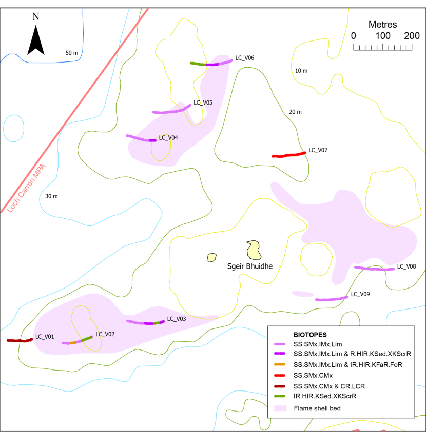
Figure 20. Distribution of biotope records around Sgeir Bhuidhe in Loch Carron.
Click for a full description
Map showing distribution of biotope records surrounding the islet Sgeir Bhuidhe in Loch Carron. Biotopes along video runs are denoted by coloration of the vessel tracks. 2017 mapping of flame shell beds (Moore et al., 2018) is shown in lilac. Also shown are video run labels, the 10 m, 20 m, 30 m and 50 m depth contours and the boundary of the Loch Carron MPA (in dark pink). © Crown copyright and database rights [2024] Ordnance Survey 100017908. Bathymetry © Crown Copyright, 2020. All rights reserved. Licence No. EK001-20140401. Not to be used for navigation.
A Limaria turf with coverage of 30 - 60% (SS.SMx.IMx.Lim) was recorded along most of the three video runs through the northern bed at a depth of 10 - 18 m, with boulders and cobbles supporting mixed kelp park and forest locally (IR.HIR.KSed.XKScrR).
Three video runs were located slightly beyond the margin of the eastern bed as recorded by the GeMS database (Scottish Government, 2024), which is based on survey work carried out in 2017 (Moore et al., 2018). Run LC_V07 lay around 100 m to the north in deeper water (20 - 26 m) where the seabed formed a mixed substrate of predominantly silty sand, gravel and pebbles supporting barnacles, serpulid worms and occasional hydroids (SS.SMx.CMx). Byssal threads were visible at the start of the run in shallower water, suggestive of the presence of Limaria hians at low density. Runs LC_V08 and LC_V09 were positioned just beyond the southern recorded margin of the bed over a depth range of 18 - 23 m. Limaria hians turf was present along both runs but with significant variation in coverage (SS.SMx.IMx.Lim). A mosaic of sand and dense, well-formed, sharply delineated turf with distinct gallery apertures was present at both ends of run LC_V08, with coverage of 50 - 60%, but within the centre of the run the coverage was reduced to around 10 - 20 % in the form of less-discrete clumps of byssus, pebbles and shells. Similar, low-density, patchy clumps were present at the eastern end of run LC_V09 (10 - 20% cover), but the turf was well-developed and formed a sharply delineated mosaic with sand (with 50% cover) at the slightly shallower western end.
3.4 Wester Ross
A total of three surveys were carried out in this region (Table 1, Figure 21), with most sample sites located within the Wester Ross MPA. The results will be described regionally, employing the sequence of geographical areas depicted in Figure 21.
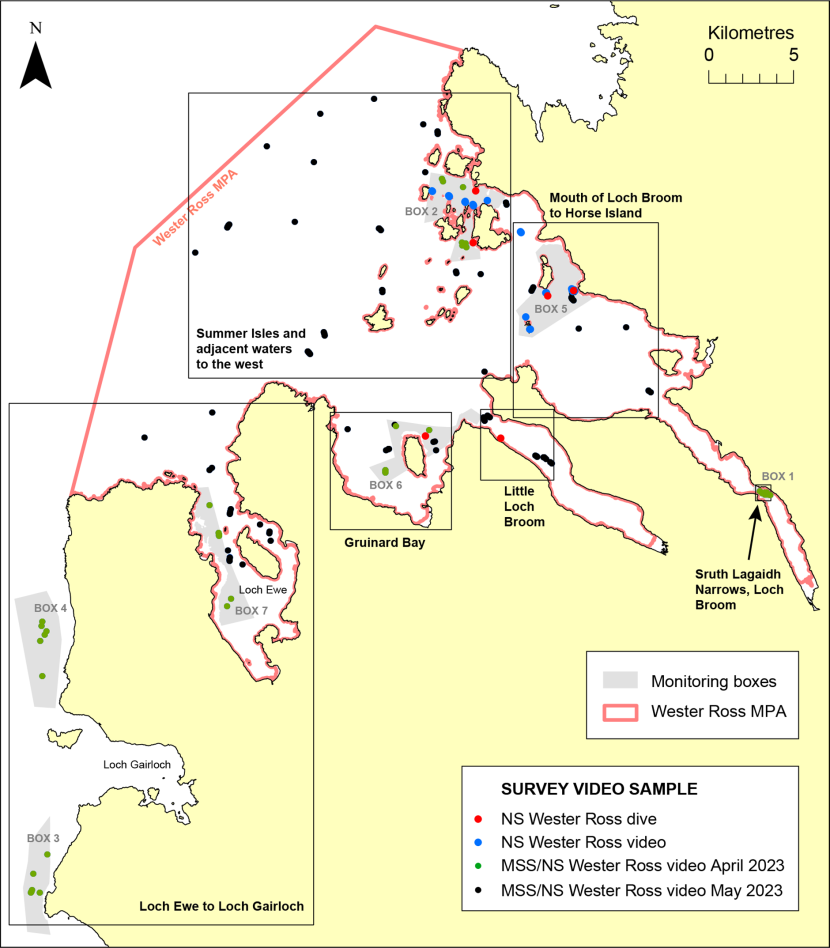
Figure 21. Distribution of sample sites for the four surveys carried out off Wester Ross. Also shown are the locations of the monitoring boxes. Black rectangles indicate the geographical regions employed in the description of results.
Click for a full description
Map of survey sample sites off Wester Ross with different coloured dots indicating the survey:
1. NS dive - red
2. NS video - blue
3. MSS/NS video April 2023 - green
4. MSS/NS video May 2023 - black
Also shown is the location of the video monitoring boxes in grey (BOXES 1 - 7), the boundary of the Wester Ross MPA in dark pink, and the following regions used in the description of results (black rectangles with name labels):
1. Sruth Lagaidh Narrows, Loch Broom
2. Little Loch Broom
3. Gruinard Bay
4. Loch Ewe to Loch Gairloch
5. Mouth of Loch Broom to Horse Island
6. Summer Isles and adjacent waters to the west
© Crown copyright and database rights [2024] Ordnance Survey 100017908.
3.4.1 Sruth Lagaidh Narrows, Loch Broom (Figure 22)
Three video runs were located in the Sruth Lagaidh Narrows and in deeper water in its south-eastern approaches. Due to the tidal acceleration in the area brittlestar beds were widespread, mostly in the form of superabundant ophiuroids dominated by Ophiothrix fragilis on a mixed substrate of gravelly, silty sand with pebbles (SS.SMx.CMx.OphMx). A flame shell bed was present along one run (W01_V03) at a depth of 17 - 33 m (SS.SMx.IMx.Lim). This was partly obscured by dense brittlestars, but where it was clearly visible it formed a well-developed mosaic of byssal turf and sand reaching around 90 - 100% turf cover and supported an abundant hydroid turf.

Figure 22. Distribution of biotope records in Sruth Lagaidh Narrows, Loch Broom.
Click for a full description
Map showing distribution of biotope records in Sruth Lagaidh Narrows, Loch Broom, using symbols differing in shape and colour to denote the different biotopes. The video track is shown as a black line with run label. 2010 mapping of a flame shell bed is shown in lilac. Also shown are the 10 m, 20 m, 30 m and 50 m depth contours, monitoring BOX 1 in grey and the boundary of the Wester Ross MPA in dark pink. © Crown copyright and database rights [2024] Ordnance Survey 100017908. Bathymetry © Crown Copyright, 2020. All rights reserved. Licence No. EK001-20140401. Not to be used for navigation.
3.4.2 Little Loch Broom (Figure 23)
The May 2023 video survey (cruise 0623a) included five runs on the outer and mid-loch sills in Little Loch Broom at 35 - 52 m depth. On the outer sill silted boulders and cobbles (CR.LCR) were scattered on a mixed sediment of gravelly, muddy sand and pebbles (SS.SMx.CMx), with the stones supporting fields of dense Leptometra celtica. At one site the stones supported a sessile fauna with frequent Axinella infundibuliformis, Caryophyllia smithii and Callistephanus (=Swiftia) pallida (CR.MCR.EcCr.CarSwi). Fields of L. celtica were also recorded at two of the runs on the mid-loch sill, which exhibited a similar substrate of a mixed muddy sand sediment (SS.SMx.CMx) with the stones also supporting Novocrania anomala (CR.LCR.BrAs). The deepest video run here (50 - 52 m) traversed sandy mud, which was locally moderately densely burrowed by megafauna including Nephrops norvegicus (SS.SMu.CFiMu.SpnMeg).
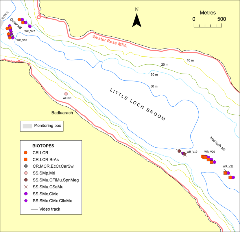
Figure 23. Distribution of biotope records in Little Loch Broom.
Click for a full description
Map showing distribution of biotope records in Little Loch Broom using symbols differing in shape and colour to denote the different biotopes. The video track is shown as a black line with run label. Also shown are the 10 m, 20 m, 30 m and 50 m depth contours, the eastern extremity of monitoring BOX 6 in grey and the boundary of the Wester Ross MPA in dark pink. © Crown copyright and database rights [2024] Ordnance Survey 100017908. Bathymetry © Crown Copyright, 2020. All rights reserved. Licence No. EK001-20140401. Not to be used for navigation.
The 2023 NatureScot dive survey included one maerl bed transect off Badluarach. This was located in an area of dense maerl at 7 m depth. Analysis of the video and still imagery indicated live maerl coverage of around 45%, with a further 45% composed of dead thalli larger than 1 cm. This material supported a dense algal cover dominated by the Trailliella phase of Bonnemaisonia hamifera, with frequent Saccharina latissima and Desmarestia spp. (SS.SMp.Mrl).
3.4.3 Gruinard Bay (Figure 24)
At depths of over 40 m the substrate recorded in Gruinard Bay was largely cohesive muddy sand, sandy mud or mud, which generally supported a low density of megafaunal burrowers and Pennatula phosphorea (SS.SMu.CFiMu.SpnMeg), and at one site Funiculina quadrangularis (SS.SMu.CFiMu.SpnMeg.Fun). From 14 - 30 m depth maerl was widely recorded (SS.SMp.Mrl), in places forming a mosaic with cobbles and boulders colonised by a red algal turf (IR.HIR.KFaR.FoR) or Spirobranchus spp. (CR.MCR.EcCr.FaAlCr.Spi). Live maerl cover reached 30% at one site (WR_V17.01) but was generally much lower and exceeded by dead maerl thalli >1 cm in length. One maerl site (WER02) was examined by diver transect which traversed an area of megarippled maerl gravel with a cover of live (15%) and dead >1 cm thalli (45%). The substrate supported a fairly sparse algal component and Neopentadactyla mixta.
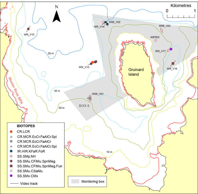
Figure 24. Distribution of biotope records in Gruinard Bay.
Click for a full description
Map showing distribution of biotope records in Gruinard Bay using symbols differing in shape and colour to denote the different biotopes. The video track is shown as a black line with run label. Also shown are the 10 m, 20 m, 30 m and 50 m depth contours, monitoring BOX 6 in grey and the boundary of the Wester Ross MPA in dark pink. © Crown copyright and database rights [2024] Ordnance Survey 100017908. Bathymetry © Crown Copyright, 2020. All rights reserved. Licence No. EK001-20140401. Not to be used for navigation.
3.4.4 Loch Ewe to Loch Gairloch (Figure 25)
The most widespread habitat observed within Loch Ewe was muddy sediment supporting moderate to dense megafaunal burrowers including Nephrops norvegicus and Calocaris macandreae, as well as seapens dominated by Pennatula phosphorea, which occurred at high densities locally (SS.SMu.CFiMu.SpnMeg). At one site occasional specimens of Funiculina quadrangularis were also observed (SS.SMu.CFiMu.SpnMeg.Fun). The burrowed mud habitat occurred in deeper parts of the loch from 35 - 55 m, but was also present in more sheltered parts of the loch at depths as shallow as 17 m. Where megafaunal burrowers were sparse, sandy mud and cohesive muddy sand sites were assigned to SS.SMu.CSaMu. Pennatula phosphorea persisted in such sediments, generally accompanied by high densities of Synarachnactis lloydii. Mixed sediments of gravelly, pebbly, muddy sand were recorded along two runs supporting high densities of S. lloydii (SS.SMx.CMx.ClloMx) and low densities (SS.SMx.CMx), in the latter case interrupted by bands of silty sand (SS.SSa.CMuSa) and medium sand formed into large ripples (SS.SCS.ICS) as the seabed shallowed to around 15 m depth near the mouth of the loch. Well-rippled medium sand was also recorded nearby (SS.SSa.IFiSa). Coarser sediment was recorded in more exposed conditions at the mouth of the loch in the form of megarippled coarse sand and gravel (SS.SCS.CCS). Algae-dominated sediments were recorded at two locations at 15 - 22 m depth. To the west of Isle of Ewe silty sand, gravel and dead maerl supported a red algal turf and occasional Virgularia mirabilis and Saccharina latissima (SS.SMp.KSwSS.SlatR). To the east of the island silty sand supported a red algal turf and sparse burrows (SS.SMp.KSwSS). The three widely-spaced video runs within and outside the mouth of the loch were all mosaics or bands of coarse sediment, cobbles and boulders, with the stones encrusted with serpulid worms, barnacles and Parasmittina trispinosa (CR.MCR.EcCr.FaAlCr). The coarse sediment was megarippled at two of the sites (SS.SCS.CCS). At the third site (WR_V01) the sediment was more mixed, with smaller stones and gravel supporting frequent hydroids and ascidians and sparse Flustra foliacea (SS.SMx.CMx.FluHyd).
Figure 25. Distribution of biotope records from Loch Ewe to Loch Gairloch.
Click for a full description
Map showing distribution of biotope records from Loch Ewe to Loch Gairloch using symbols differing in shape and colour to denote the different biotopes. The video track is shown as a black line with run label. Also shown are the 10 m, 20 m, 30 m and 50 m depth contours, monitoring BOXES 3, 4 and 7 in grey, and the boundary of the Wester Ross MPA in dark pink. © Crown copyright and database rights [2024] Ordnance Survey 100017908. Bathymetry © Crown Copyright, 2020. All rights reserved. Licence No. EK001-20140401. Not to be used for navigation.
Four video runs were located west of Loch Ewe at around the 20 m depth contour just north of Loch Gairloch (W04_V01 - V04). The sediment here was predominantly megarippled coarse sand, maerl and shell gravel, with live maerl sparse (SS.SCS.CCS, SS.SCS.CCS.Nmix) or becoming frequent at least within ripple troughs (SS.SMp.Mrl). Along one run sector (W04_V02.02) live maerl cover was common overall (20%) but became abundant (60%) locally. Scattered cobbles and boulders along two of the runs supported a turf of hydroids (CR.HCR.XFa). A further four runs were located south of Loch Gairloch (W03_V01 - V04). The two inshore runs at 15 - 20 m depth traversed partially megarippled coarse sand and gravel supporting Neopentadactyla mixta and fairly low overall densities of live maerl, although it became common (20 - 30%) in patches along both runs (SS.SMp.Mrl). The two deeper runs at 38 - 42 m traversed a seabed of slightly silty, gravelly sand (SS.SSa.CMuSa), which along one run formed a mosaic with boulders and cobbles supporting a hydroid turf, Diazona violacea and Axinella infundibuliformis (CR.HCR.XFa).
3.4.5 Mouth of Loch Broom to Horse Island (Figures 26, 27)
Areas of deeper water (around 40 - 50 m) included several records of burrowed mud (SS.SMu.CFiMu.SpnMeg) supporting low to moderate densities of megafaunal burrowers, and along one run off Rubha Dubh Ard occasional Funiculina quadrangularis (SS.SMu.CFiMu.SpnMeg.Fun). A dense population of Calocaris macandreae was observed at the deepest burrowed mud site, WR_V26 (97 m). At several sites in this region the cohesive, muddy sediment was mixed with gravel, shells and pebbles, sometimes supporting sparse megafaunal burrows (SS.SMx.CMx), and formed a mosaic with scattered, often silted, cobbles and boulders encrusted with serpulid worms, barnacles, Parasmittina trispinosa and pink coralline algae, and supporting sparse or patchy hydroids (CR.LCR), and at one site (WR_V28) a field of Leptometra celtica.
Figure 26. Distribution of biotope records from the mouth of Loch Broom to Horse Island.
Click for a full description
Map showing distribution of biotope records from the mouth of Loch Broom to Horse Island using symbols differing in shape and colour to denote the different biotopes. The video track is shown as a black line with video run label. Also shown are the 10 m, 20 m, 30 m, 50 m and 100 m depth contours, monitoring BOX 5 in grey and the boundary of the Wester Ross MPA in dark pink. Black rectangle west of Rubha Dubh Ard shows area where detail is presented in Figure 27. © Crown copyright and database rights [2024] Ordnance Survey 100017908. Bathymetry © Crown Copyright, 2020. All rights reserved. Licence No. EK001-20140401. Not to be used for navigation.
Shallower waters were examined around the Carn Skerries, south of Horse Island and west of Rubha Dubh Ard. Maerl beds (SS.SMp.Mrl) were recorded to the north and south of the Carn Skerries. The southern bed at a depth of 10 - 11 m was composed of frequent live maerl on a sandy, gravelly, shelly substrate supporting an abundant red algal turf and frequent Saccharina latissima. With a reduction in the live maerl content farther along the video run, the biotope SS.SMp.KSwSS.SlatR.Gv was recognised. The northern maerl bed was in deeper water (14 - 18 m) but of similar biotic composition to the southern maerl bed, except for the unusual presence of Virgularia mirabilis.
Maerl was also recorded along the two survey south of Horse Island, but was only rare along the video run WER_DDV25, where bedrock outcrops, cobbles and boulders, probably scoured, supporting frequent Saccharina latissima and a superabundant turf of filamentous/filiform red algae (IR.HIR.KSed) on coarse sediment (SS.SCS.ICS) transitioned to a mixed gravelly sand substrate with abundant Synarachnactis lloydii (SS.SMx.CMx.ClloMx).at a depth of 15 m. Maerl was richer along the dive transect WER06 in slightly shallower water (12 - 13 m). Here, live maerl attained around 7% overall cover (occasional), but reached 20% locally in the presence of shell patches (SS.SMp.Mrl). Contemporaneous overall live maerl estimates obtained by diver were slightly higher at 13%.
Three video runs and one diver transect were located at depths of 6 - 15 m off Rubha Dubh Ard in an area colloquially known as Planet Rock (Figure 27). Video runs WER_DDV05B and WER_DDV05C traversed maerl beds (SS.SMp.Mrl) with high coverage of live thalli (25% - common). The shallower, latter site (8 m depth) exhibited a dense turf of red algae, as well as Saccharina latissima, but the former site at 15 m depth appeared to be of low diversity with a sparse associated algal component. The dive transect at 11 - 13 m depth (WER05) also crossed a maerl bed (SS.SMp.Mrl). Live maerl coverage was lower (around 10% - frequent), but there was a high level of dead maerl >1 cm (38%) and the coarse substrate supported a superabundant turf of filamentous/filiform red algae. Limaria hians was present amongst the maerl along the dive transect and run WER_DDV05C, where it was possibly responsible for clumping the maerl material (SS.SMx.IMx.Lim). Limaria turf cover was difficult to judge but possibly attained around 30% along the video run. The flame shell habitat was also recorded as the sole biotope or in association with scattered cobbles and boulders clothed in a red algal turf (IR.HIR.KFaR.FoR) along two of the video runs, where turf coverage was around 30%. Probably sand-scoured bedrock outcrops, boulders and cobbles supported kelp park and forest of Laminaria hyperborea and/or S. latissima along two video runs (IR.HIR.KSed).
Figure 27. Distribution of biotope records west of Rubha Dubh Ard (‘Planet Rock’).
Click for a full description
Map showing distribution of biotope records off Rubha Dubh Ard, colloquially known as ‘Planet Rock’. See box in Figure 26 for location. Vessel tracks are coloured according to biotope and symbols differing in shape and colour denote the biotope midpoint. Also shown are the video run labels and the 10 m and 20 m depth contours. © Crown copyright and database rights [2024] Ordnance Survey 100017908. Bathymetry © Crown Copyright, 2020. All rights reserved. Licence No. EK001-20140401. Not to be used for navigation.
3.4.6 Summer Isles and adjacent waters to the west (Figure 28)
Much of this area lies beyond the 50 m depth contour, where the predominant habitat was cohesive muddy sand or sandy mud grading to soft mud in deeper water. This was populated by megafaunal burrowers, especially Nephrops norvegicus and Calocaris macandreae, mostly at light to moderate densities (SS.SMu.CFiMu.SpnMeg), but becoming dense at depths over 110 m, where Funiculina quadrangularis was also present at high density (SS.SMu.CFiMu.SpnMeg.Fun). From around 30 m to 50 m depth, but locally extending to significantly greater depths, the predominant substrate recorded was muddy sand. Where the sediment was homogeneous, sparse small burrows were sometimes present but little visible fauna was evident (SS.SSa.CMuSa). However, more commonly the muddy sand was mixed with gravel and pebble components, with the larger stones encrusted with serpulid worms and barnacle spat and supporting sparse hydroids and an epifauna dominated by Munida rugosa (SS.SMx.CMx) or occasionally by dense Synarachnactis lloydii (SS.SMx.CMx.ClloMx). At several locations such mixed sediments formed a mosaic with scattered cobbles and boulders, sometimes silted and supporting a patchy hydroid turf (CR.LCR), or with unsilted cobbles, boulders and bedrock outcrops with sparse hydroids but encrustations of serpulid worms, barnacles and Parasmittina trispinosa (CR.MCR.EcCr.FaAlCr or CR.MCR.EcCr.FaAlCr.Spi where serpulids were abundant). At five locations in deep water (46 - 95 m) the rock supported a more diverse fauna of sponges (Axinella infundibuliformis, Iophon nigricans? and Polymastia boletiformis), a hydroid turf, Porella compressa and ascidians including Diazona violacea (CR.HCR.DpSp.PhaAxi), in addition to frequent Callistephanus pallida at one site (CR.MCR.EcCr.CarSwi).
Figure 28. Distribution of biotope records from the Summer Isles and adjacent waters to the west.
Click for a full description
Map showing distribution of biotope records from the Summer Isles and adjacent waters to the west using symbols differing in shape and colour to denote the different biotopes. The video track is shown as a black line with run labels. Also shown are the 10 m, 20 m, 30 m, 50 m and 100 m depth contours, monitoring BOX 2 in grey and the boundary of the Wester Ross MPA in dark pink. © Crown copyright and database rights [2024] Ordnance Survey 100017908. Bathymetry © Crown Copyright, 2020. All rights reserved. Licence No. EK001-20140401. Not to be used for navigation.
Infralittoral rock biotopes were recorded in the Dorney Sound north of the Summer Isles, mostly in the form of Laminaria hyperborea forest (IR.MIR.KR.Lhyp.Ft) and park (IR.MIR.KR.Lhyp.Pk) at 7 - 23 m depth. IR.HIR.KFaR.FoR was recognised in the presence of a dense red algal turf but where kelp was sparse. Two examples of red algal turfs and sparse Saccharina latissima on coarse sediment were also recorded in Dorney Sound (SS.SMp.KSwSS.SlatR, SS.SMp.KSwSS.SlatR.Gv), as well as off Cailleach Head at the mouth of Little Loch Broom (SS.SMp.KSwSS.SlatR.Gv).
Patchy live maerl (locally common) was also recorded at the latter Cailleach Head site (SS.SMp.Mrl). A further maerl bed site at 13 - 15 m depth in Mol Mòr Bay, south-west Tanera More, was examined by diver transect. The substrate of dead maerl and silty sand supported a live maerl cover of around 25% (common) and a superabundant red filamentous algal turf, as well as Neopentadactyla mixta (SS.SMp.Mrl).
3.5 Loch Eriboll (Figure 29)
Due to the poor visibility for most of the video clips at the head of the loch south of Eilean Choraidh, and the absence of video footage covering the landing of the camera frame (when the seabed disturbance can provide valuable information regarding sediment type), detailed biotope identification was often not possible. The sediment in this area was probably largely muddy sand and/or sandy mud, so has been referred to the broad habitat level 2 category SS (sublittoral sediment). One exception was at the innermost station W1 where the camera was apparently deployed in a stream running over the shore. The substrate of gravel and pebbles supported Fucus vesiculosus and encrustations of serpulid worms (IR.LIR.Lag). Around the edges of the loch northwards to Ard Neackie and around Eilean Choraidh muddy sand with scattered gravel, pebbles and cobbles supported a filamentous/filiform red algal turf and varying densities of Saccharina latissima at depths of 5 - 19 m (SS.SMp.KSwSS.SlatR). In shallower waters mixed forests of S. latissima and Laminaria spp., presumably on rock, were present around the south of Eilean Choraidh at 4 m depth (IR.LIR.K.LhypSlat.Ft).
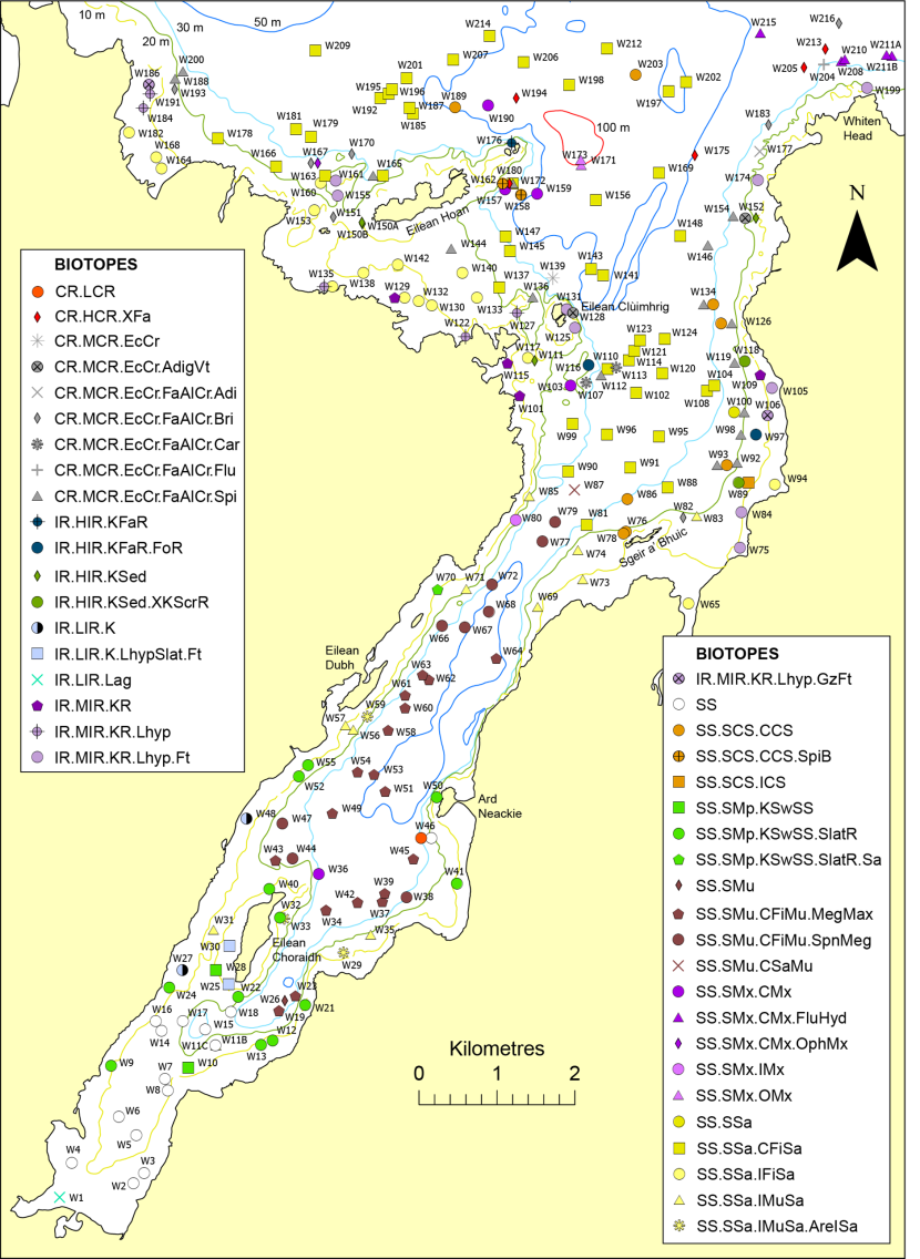
Figure 29. Distribution of biotope records in Loch Eriboll.
Click for a full description
Map showing distribution of biotope records in Loch Eriboll using symbols differing in shape and colour to denote the different biotopes. Also shown are site labels and the 10 m, 20 m, 30 m, 50 m and 100 m depth contours. © Crown copyright and database rights [2024] Ordnance Survey 100017908. Bathymetry © Crown Copyright, 2020. All rights reserved. Licence No. EK001-20140401. Not to be used for navigation.
From the north of Eilean Charaidh to Eilean Dubh the loch at depths of 24 - 54 m was floored predominantly by mud burrowed by megafauna including Nephrops norvegicus, and with mounds, often dense, of Maxmuelleria lankesteri (SS.SMu.CFiMu.MegMax). From Eilean Dubh northwards to Sgeir a’Bhuic where the loch widens, megafaunally burrowed mud continued over the same depth range but apparently lacking the Maxmuelleria component (SS.SMu.CFiMu.SpnMeg). In shallower waters inshore of the mud, muddy sand sediments were recorded, tentatively ascribed to SS.SSa.IMuSa. Mud content appeared low and the sediment often displayed a diatomaceous or possibly detrital film and was formed into ripples locally. Arenicola spp. mounds were common at two of the sites (SS.SSa.IMuSa.AreISa).
Fine sand was the dominant habitat over an extensive area of the more exposed outer region of the loch north of Sgeir a’Bhuic. The sediment occurred over a wide depth range (22 - 73 m) and was generally formed into ripples (SS.SSa.CFiSa). Widely recorded biotic features included pleuronectid flatfish and Ophiura ophiura. At some sites the apparent presence of a minor mud content and small mounds may be indicative of a different biotope. Shallow inshore sediments in the mouth of the loch west of Eilean Clùimhrig consisted of rippled, fine - medium sand over a depth range of mainly 3 - 19 m, typically supporting Polybius (=Liocarcinus) spp. and pleuronectid flatfish (SS.SSa.IFiSa). Several records of mixed substrates of mostly sand, gravel and pebbles were located largely in the outer region of the loch (SS.SMx,CMx), with an area of coarser mixed substrates at the north-eastern mouth. Here a mix of predominantly pebbles and small cobbles supported dense Spirobranchus spp., robust hydroids and occasional Flustra foliacea at a depth of 33 - 49 m (SS.SMx.CMx.FluHyd). The mobility of the substrate was illustrated by the formation of megaripples at some sites.
Kelp habitats were recorded at 28 locations, largely in the outer region of the loch. The SBRUV sampling method was particularly poor at facilitating characterisation of such habitats and all biotope designations are considered tentative. Forests of Laminaria hyperborea on bedrock with a red algal understorey were widely recorded in the outer region of the loch, mostly over a depth range of 2 - 13 m, but extending to 22 m depth at some of the most exposed sites (IR.MIR.KR.Lhyp.Ft). At two sites records were ascribed to IR.MIR.KR.Lhyp.GzFt where an algal turf was seemingly absent. At several sites the substrate and understorey biota was not visible or barely discernible and so the habitats have been ascribed to higher level biotope classes (IR.LIR, IR.MIR.KR).
The predominantly sedimentary seabed in the outer part of the loch north of Sgeir a’Bhuic was interrupted over a wide area by bedrock outcrops and fields of cobbles and boulders populated by an encrusting biota of dense serpulid worms with Parasmittina trispinosa and pink coralline algae over a depth range of 19 - 37 m (CR.MCR.EcCr.FaAlCr.Spi). At a small number of sites the encrusting biota was accompanied by dense Caryophyllia smithii (CR.MCR.EcCr.FaAlCr.Car), while in probably more tide-swept areas such as off Whiten Head and in the channel west of Eilean Hoan, the rock supported dense beds of Ophiothrix fragilis and/or Ophiocomina nigra (CR.MCR.EcCr.FaAlCr.Bri). At five sites in the outermost part of the loch at 29 - 68 m depth, patches of bedrock, boulders and cobbles supported a dense faunal turf dominated by hydroids and bryozoans including Flustra foliacea (CR.HCR.XFa). The fauna was particularly richly developed at site W180, with the addition of sponges, Alcyonium digitatum and Conger conger (Figure 30).
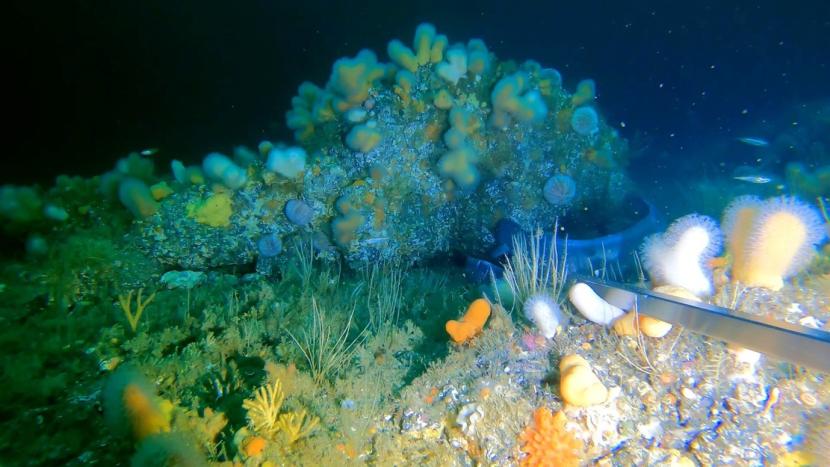
Figure 30. Rich hydroid and bryozoan turf with Alcyonium digitatum, sponges and Conger conger (Loch Eriboll, site W180).
Click for a full description
Video frame grab from site W180, Loch Eriboll, showing a rich faunal turf of hydroids, bryozoans, Alcyonium digitatum and branching and other sponges, with conger eel.
4. Discussion
This section considers the conservation importance of the species and habitats encountered during the surveys, while also providing a summary appraisal of the distribution of PMFs, MPA protected features and EC Habitats Directive Annex I habitats. The conservation importance of species and habitats and their occurrence in each of the survey locations is summarised in Table 2, with the occurrence of Annex I habitats given in Table 3. Over half the biotopes in Table 2 fall within broad habitat types included in the Scottish Biodiversity List (Scottish Government, 2013) but are not recognised by other indicators of conservation importance. Such biotopes are generally of wide occurrence in Scottish waters. This section also serves to provide a temporal comparison of the presence and condition of habitats with those reported by previous surveys.
| Biotope/species | SBL | Osp | PMF | PF | Clyde Sea | Loch Carron | Barra | Wester Ross | Loch Eriboll |
|---|---|---|---|---|---|---|---|---|---|
| CR.HCR.DpSp.PhaAxi | ● | - | ● | - | - | - | - | 5 | - |
| CR.MCR.EcCr.CarSwi | ● | - | ● | - | - | - | - | 2 | - |
| IR.LIR.Lag | - | - | ● | - | - | - | - | - | 1 |
| IR.MIR.KR.Lhyp | - | - | ● | - | - | - | - | - | 5 |
| IR.MIR.KR.Lhyp.Ft | - | - | ● | - | 1 | - | - | 2 | 9 |
| IR.MIR.KR.Lhyp.GzFt | - | - | ● | - | - | - | - | - | 2 |
| IR.MIR.KR.Lhyp.Pk | - | - | ● | - | - | - | - | 2 | - |
| IR.MIR.KT.XKTX | ● | - | ● | - | 1 | - | - | - | - |
| SS | ● | - | - | - | - | - | - | - | 14 |
| SS.SCS.CCS | ● | - | - | ● | 27 (1CS) | - | 44 | 6 | 8 |
| SS.SCS.CCS.Nmix | ● | - | ● | ● | - | - | - | 1 | - |
| SS.SCS.CCS.SpiB | ● | - | - | ● | 2 | - | - | 1 | 2 |
| SS.SCS.ICS | ● | - | - | - | - | - | 16 | 4 | 1 |
| SS.SMp.KSwSS | - | - | ● | ● | - | - | - | 1 | 2 |
| SS.SMp.KSwSS.SlatR | - | - | ● | ● | 2 (1SA) | - | - | 2 | 12 |
| SS.SMp.KSwSS.SlatR.CbPb | ● | - | ● | ● | 3SA | - | - | - | - |
| SS.SMp.KSwSS.SlatR.Gv | - | - | ● | ● | 8 (4SA) | - | - | 3 | - |
| SS.SMp.KSwSS.SlatR.Sa | - | - | ● | ● | - | - | - | - | 1 |
| SS.SMp.Mrl | ● | ● | ● | ● | 16 (15SA) | - | 41 | 22 | - |
| SS.SMp.SSgr.Zmar | ● | ● | ● | ● | 1SA | - | - | - | - |
| SS.SMu.CFiMu | ● | - | - | - | 1 | - | - | - | - |
| SS.SMu.CFiMu.MegMax | ● | - | ● | ● | - | - | - | - | 18 |
| SS.SMu.CFiMu.SpnMeg | ● | - | ● | ● | 264 (171SA) | - | - | 24 | 9 |
| SS.SMu.CFiMu.SpnMeg.Fun | ● | - | ● | ● | - | - | - | 8 | - |
| SS.SMu.CSaMu | ● | - | - | - | 60 | - | - | 8 | 1 |
| SS.SMx.CMx | ● | - | - | - | 58 | 2 | 1 | 47 | 5 |
| SS.SMx.CMx.ClloMx | ● | - | - | - | 8 | - | - | 11 | - |
| SS.SMx.CMx.ClloMx.Nem | ● | - | - | - | 5 | - | - | - | - |
| SS.SMx.CMx.FluHyd | ● | - | - | - | 14 | - | - | 1 | 5 |
| SS.SMx.CMx.OphMx | ● | - | - | - | 32 | - | - | 6 | 1 |
| SS.SMx.IMx | ● | - | - | - | 5 | - | - | 1 | 1 |
| SS.SMx.IMx.Lim | ● | - | ● | ● | 14 | 15 | - | 6 | - |
| SS.SMx.OMx | ● | - | - | - | - | - | - | - | 2 |
| SS.SSa | ● | - | - | - | - | - | - | - | 1 |
| SS.SSa.CFiSa | ● | - | - | ● | 2CS | - | 11 | - | 45 |
| SS.SSa.CMuSa | ● | - | - | ● | 16 | - | - | 15 | 5 |
| SS.SSa.IFiSa | ● | - | - | - | - | - | - | 1 | 16 |
| SS.SSa.IMuSa | ● | - | - | - | - | - | 8 | - | 6 |
| SS.SSa.IMuSa.AreISa | ● | - | - | - | - | - | - | - | 3 |
| SS.SSa.IMuSa.EcorEns | ● | - | - | - | 1 | - | - | - | - |
| Funiculina quadrangularis | - | - | ● | ● | - | - | - | 9 | - |
| Callistephanus pallida | - | - | ● | - | - | - | - | 4 | - |
| Pachycerianthus multiplicatus | - | - | ● | ● | - | - | - | 3 | - |
| Arctica islandica | - | - | ● | - | 1 | - | 1 | 6 | - |
| Leptometra celtica | - | - | ● | - | - | - | - | 14 | - |
| Leptometra celtica aggregation | - | - | ● | ● | - | - | - | 8 | - |
| Merlangius merlangus | - | - | ● | - | - | - | - | - | 17 |
| Gadus morhua | - | - | ● | - | - | - | - | - | 8 |
| Ammodytes spp. | - | - | ● | - | - | - | 9 | 2 | - |
| Habitat | Sub-type/feature | Clyde Sea | Barra | Loch Carron | Wester Ross | Loch Eriboll |
|---|---|---|---|---|---|---|
| Reefs | unclassified | 0 | 0 | 0 | 0 | 11 |
| Reefs | bedrock | 11 | 63 | 4 | 18 | 32 |
| Reefs | stony | 34 | 0 | 6 | 65 | 30 |
| Subtidal sandbanks | gravelly & clean sands | 0 | 71 | 0 | 0 | 0 |
| Subtidal sandbanks | kelp & seaweed | 0 | 0 | 0 | 0 | 0 |
| Subtidal sandbanks | maerl beds | 6 | 41 | 0 | 0 | 0 |
| Subtidal sandbanks | muddy sands | 1 | 8 | 0 | 0 | 0 |
| Subtidal sandbanks | mixed sediments | 6 | 1 | 17 | 4 | 0 |
4.1 Clyde Sea (Clyde Sea Sill and South Arran)
The Annex I reef habitat was widely recorded in the surveyed area but largely above the 30 m depth contour (Figure 31, Table 3) and mostly in the form of stony reefs of cobbles and boulders. The greatest concentration of records lay within monitoring boxes FS and Arr07 (Figure 34) in an area of accelerated currents south-west of Pladda. This was also the site of most of the bedrock reef records. Strict application of the Habitats Directive definition of a sandbank as being ‘predominantly surrounded by deeper water’ (European Commission, 2013) excludes much of the shallow sediment areas around Arran, although the shallow sills of the north and south entrance channels to Lamlash Harbour could be considered to display examples of five of the six subtidal sandbank sub-types: gravelly and clean sands, mixed sediments, muddy sands, maerl beds and kelp and seaweed.
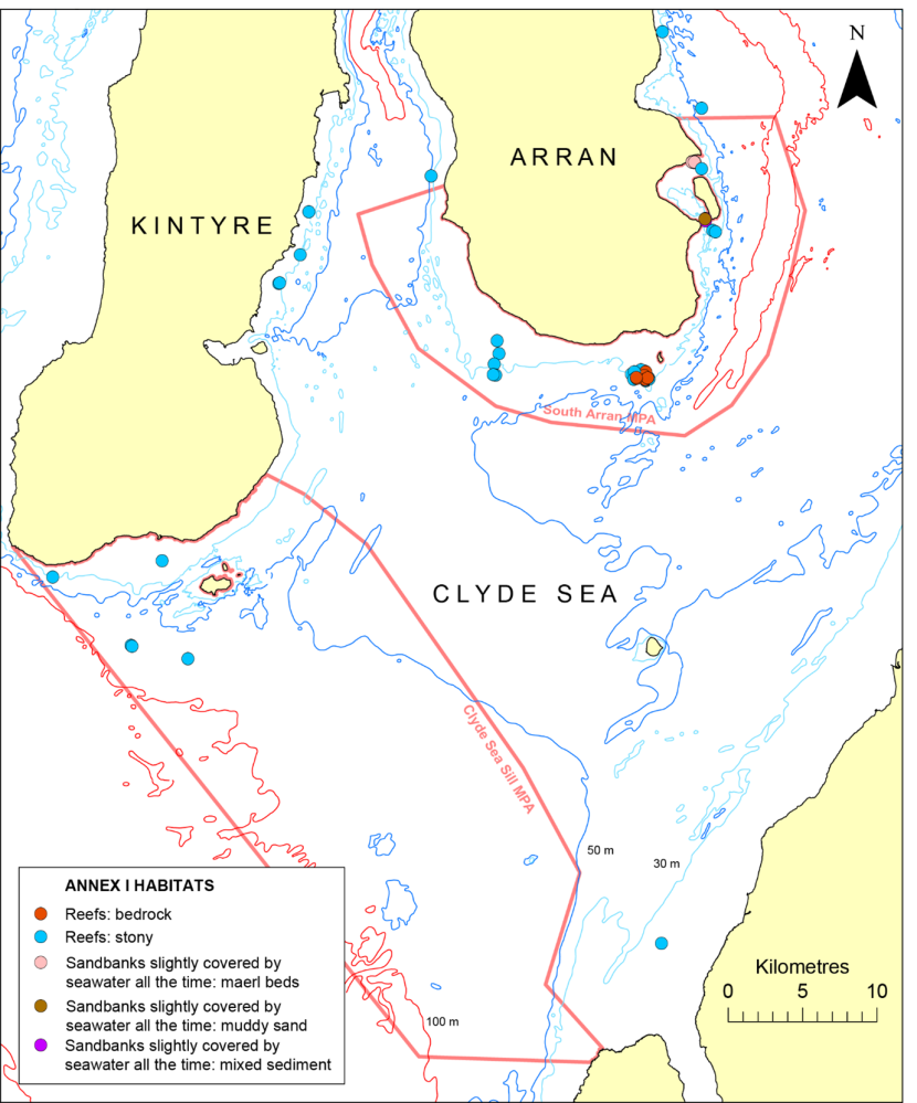
Figure 31. Distribution of records of Annex I habitats from the Clyde Sea.
Click for a full description
Map showing distribution of records of Habitats Directive Annex I habitats in the Clyde Sea using symbols differing in colour to denote the different habitats. Also shown are the 30 m, 50 m and 100 m depth contours and the boundaries of the South Arran and Clyde Sea Sill MPAs in dark pink. © Crown copyright and database rights [2024] Ordnance Survey 100017908. Bathymetry © Crown Copyright, 2020. All rights reserved. Licence No. EK001-20140401. Not to be used for navigation.
PMF habitats recorded within the Clyde Sea Sill MPA and adjacent waters included six examples of burrowed mud (SS.SMu.CFiMu.SpnMeg) and single records of the tide-swept algal community biotope (IR.MIR.KT.XKTX) and a maerl bed (SS.SMp.Mrl) off Kintyre (Figure 32). Also present within the MPA were three examples of the protected feature ‘circalittoral and offshore sand and coarse sediment communities’ in the form of SS.SSa.CFiSa and SS.SCS.CCS. In terms of comparisons with historical records within this region, the only notable difference was the recording of the presence of the maerl bed in the north of the MPA during the current 2021 survey work. However, it represented a poor example of the habitat being strongly dominated by dead maerl, with sparse live thalli and a poorly developed epibiotic community.
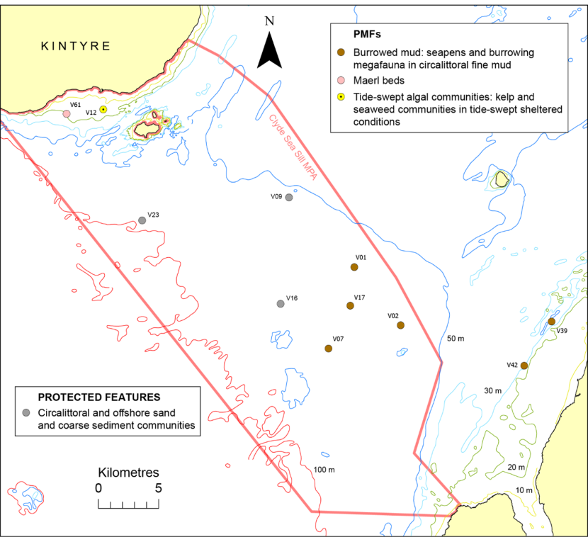
Figure 32. Distribution of protected features and PMFs on the Clyde Sea Sill and in adjacent waters.
Click for a full description
Map showing distribution of protected feature and PMF records on the Clyde Sea Sill and in adjacent waters using symbols differing in shape and colour to denote the different features. Also shown are the video run labels, the 10 m, 20 m, 30 m, 50 m and 100 m depth contours and the boundary of the Clyde Sea Sill MPA in dark pink. © Crown copyright and database rights [2024] Ordnance Survey 100017908. Bathymetry © Crown Copyright, 2020. All rights reserved. Licence No. EK001-20140401. Not to be used for navigation.
Protected feature and PMF records around Arran are shown in Figures 33 - 36. Four of the seven protected features of the South Arran MPA were recorded within its boundary, of which by far the dominant was burrowed mud, widely present (at 171 sample sites) beyond the 40 m depth contour. Clusters of maerl bed records were present to the north of Pladda (Figure 34) and off the southern and northern coasts of Holy Island (Figure 35), where most of the records of ‘kelp and seaweed communities on sublittoral sediment’ were also located. Several records of this protected feature and PMF were also observed beyond the MPA limits north of Brodick Bay (Figure 36) and along the Kintyre coast (Figure 33). A single seagrass bed site was observed by dive transect in Whiting Bay (Figure 35). Three of the South Arran MPA protected features were not recorded, probably resulting from spatial differences between survey site locations and the known distribution of the features. Siphons of the PMF Arctica islandica (ocean quahog) were observed at a single site north of Brodick Bay (Figure 36), but aggregations of the species (a protected feature) were not recorded.
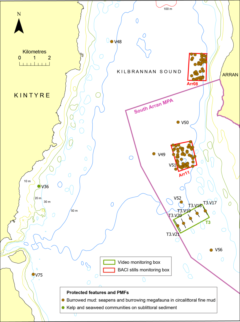
Figure 33. Distribution of protected features and PMFs in Kilbrannan Sound and its southern approaches.
Click for a full description
Map showing distribution of protected feature and PMF records in Kilbrannan Sound and its southern approaches using symbols differing in shape and colour to denote the different features. Also shown are the 10 m, 20 m, 30 m, 50 m and 100 m depth contours, the video monitoring boxes (in green), BACI stills monitoring boxes (in red) and the boundary of the South Arran MPA (dark pink line). The video track is shown as a black line with the run label, although for short runs the track will be occluded by the biotope symbol. © Crown copyright and database rights [2024] Ordnance Survey 100017908. Bathymetry © Crown Copyright, 2020. All rights reserved. Licence No. EK001-20140401. Not to be used for navigation.
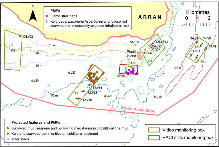
Figure 34. Distribution of protected feature and PMF records along the southern coastline of Arran.
Click for a full description
Map showing distribution of protected feature and PMF records off the southern coastline of Arran using symbols differing in shape and colour to denote the different features. Also shown are the 10 m, 20 m, 30 m and 50 m depth contours, the video monitoring boxes (in green), BACI stills monitoring boxes (in red) and the boundary of the South Arran MPA (dark pink line). The video track is shown as a black line with the run label, although for short runs the track will be occluded by the feature symbol. © Crown copyright and database rights [2024] Ordnance Survey 100017908. Bathymetry © Crown Copyright, 2020. All rights reserved. Licence No. EK001-20140401. Not to be used for navigation.
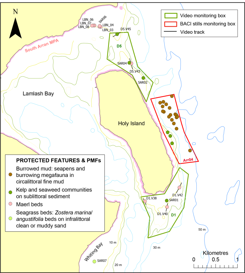
Figure 35. Distribution of protected feature and PMF records around Holy Island, Arran.
Click for a full description
Map showing distribution of protected feature and PMF records around Holy Island, Arran using symbols differing in shape and colour to denote the different features. Also shown are the 10 m, 20 m, 30 m and 50 m depth contours, the video monitoring boxes (in green), BACI stills monitoring boxes (in red) and the boundary of the South Arran MPA (dark pink line). The video track is shown as a black line with the run label, although for short runs the track will be occluded by the feature symbol. © Crown copyright and database rights [2024] Ordnance Survey 100017908. Bathymetry © Crown Copyright, 2020. All rights reserved. Licence No. EK001-20140401. Not to be used for navigation.
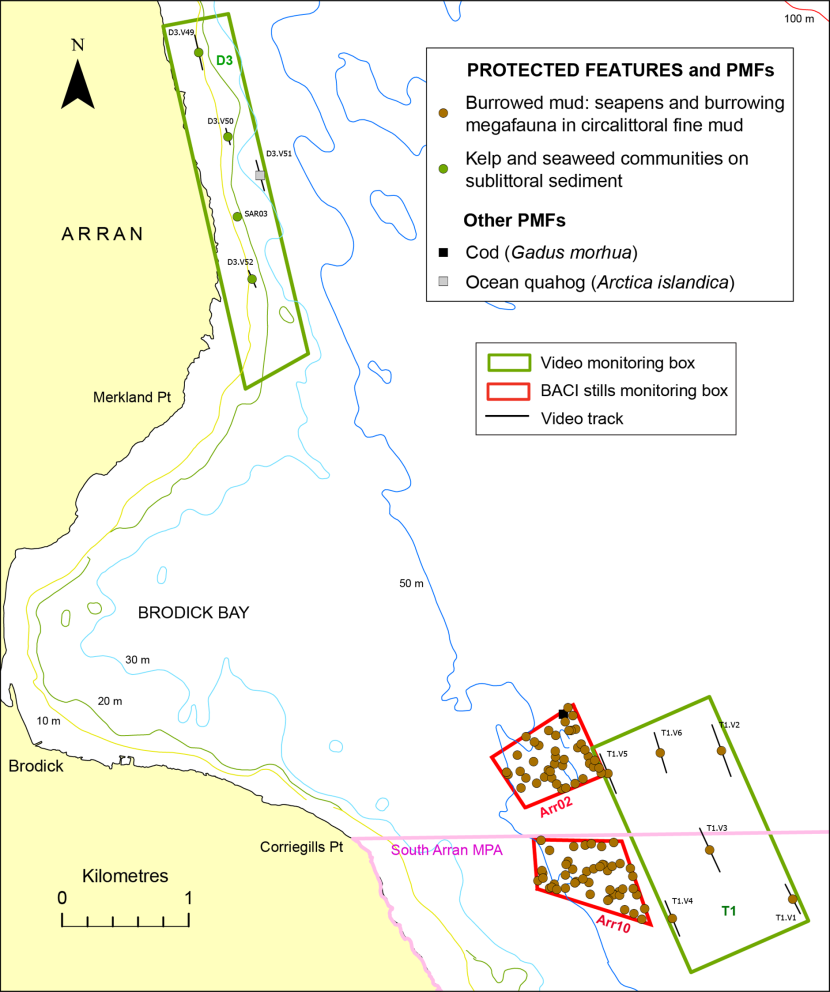
Figure 36. Distribution of protected feature and PMF records off Brodick Bay, Arran.
Click for a full description
Map showing distribution of protected feature and PMF records off Brodick Bay, Arran using symbols differing in shape and colour to denote the different features. Also shown are the 10 m, 20 m, 30 m, 50 m and 100 m depth contours, the video monitoring boxes (in green), BACI stills monitoring boxes (in red) and the boundary of the South Arran MPA (dark pink line). The video track is shown as a black line with the run label, although for short runs the track will be occluded by the feature symbol. © Crown copyright and database rights [2024] Ordnance Survey 100017908. Bathymetry © Crown Copyright, 2020. All rights reserved. Licence No. EK001-20140401. Not to be used for navigation.
Doggett et al. (2024) have identified statistically significant change in the abundance of components of the maerl bed community off Pladda and Holy Island between 2014 and 2018 based on multivariate analysis of SACFOR data collected by dropdown video along multiple transects. Such a detailed approach lies beyond the remit of the current investigation, which is limited to the identification of distinct changes in biotope identity, composition and condition clearly discernible by comparison of recent survey results with historical data.
Amongst the best comparative historical data are the diving surveys carried out along five 25 m transects and one 50 m diameter spot location in 2014 (Mercer et al., 2018) and repeated in 2023 (sites SAR01, 02, 04, 05 and 06) with the collection of high quality video and stills imagery. A seventh 2023 dive transect site (SAR03) was previously surveyed by dropdown video in 2018 (site STN_17). No temporal change in biotope was recorded at sites to the north (SAR02, 04) or south (SAR01) of Holy Island (SS.SMp.KSwSS.SlatR.Gv) (Figure 35), off Pladda (SAR05 - SS.SMp.Mrl) (Figure 34), in Lamlash Bay (SAR06 - SS.SMp.Mrl) or in Whiting Bay (SAR07 - SS.SMp.SSgr.Zmar) (Figure 35). On the other hand, at site SAR03 in box D3 just north of Brodick Bay (Figure 36) a maerl bed was recorded in 2018 (SS.SMp.Mrl) but SS.SMp.KSwSS.SlatR.Gv was recorded in 2023. The difference reflects a change in the characteristics considered to define a maerl bed biotope. Only dead maerl was recorded in both years, but maerl fragment size was not noted in the earlier study which reported maerl ‘twigs’/gravel as common (i.e. 20-39% cover). In 2023 comminuted maerl gravel was estimated at 80% and dead thalli (>1 cm long) at 10%. There are several historical maerl bed records in the shallower waters of box D3 with live maerl at most described as rare. Sites in this region in 2023 have been largely referred to SS.SMp.KSwSS biotopes, again reflecting the temporal difference in maerl biotope definition.
At the Whiting Bay seagrass bed site, SAR07, there was no change in the SACFOR abundance of Zostera marina recorded in 2014 and 2023, but the density of the invasive red alga Dasysiphonia japonica had clearly declined. This was frequent in 2014, but all filamentous/filform red algae combined were rare in 2023. There was little evidence for significant temporal change at the other diver transect sites, apart from a general decline in the density of D. japonica.
The presence of a flame shell bed off Pladda with an estimated extent of 1 ha has been known since 2020 (COAST, 2020), The details have not been documented in the Marine Recorder or GeMS databases, but the location of 2020 -2022 COAST dive records of the habitat are provided in Figure 6. The 2021 survey work suggests the presence of a considerably more extensive bed (40 ha), albeit with highly patchy and often low density byssal coverage. The difference in extent estimates probably reflects the paucity of historical sampling effort in the area. Further diving work is recommended to confirm and expand the 2021 remote observations.
The 2021 Arran survey revealed one possible temporal change in the condition of the burrowed mud habitat in the form of a reduction in anthropogenic perturbation. In 2015 (Moore, 2021) presumptive trawl scars were observed at seven locations within four of the video monitoring boxes (T1, T2, T3 and T4). Multiple video runs were carried out in each of these boxes in 2021 but no evidence of anthropogenic perturbation of the mud was evident. However, faint parallel scarring of burrowed mud was observed at four sites within the BACI monitoring boxes Arr08 and Arr11 (viz. Arr08_24, Arr08_48, Arr11_04 and Arr11_26). Although all mobile demersal fishing has been banned for much of the MPA since 2016, all of these sites are located in areas where trawling has not been prohibited, although the Arr11 sites lie within an area where it is restricted to vessels up to 120 tonnes (Figure 2).
4.2 Sound of Barra
The Barra monitoring boxes comprised essentially mosaics of the Annex I habitat features: bedrock reefs, subtidal sandbanks (gravelly and clean sands) and subtidal sandbanks (maerl beds), all of which were widespread (Figures 37 - 39, Table 3), although maerl beds were unrecorded (box S2) or recorded infrequently (boxes S8, S9, S10) beyond the Sound of Barra SAC limits (Figures 37, 39). There was significant representation of the feature subtidal sandbanks (muddy sand) in box S7 (Figure 38).
Figure 37. Distribution of Annex I habitat and PMF records in the north-eastern region surveyed off the Sound of Barra.
Click for a full description
Map showing distribution of records of EC Habitats Directive Annex I habitats and PMFs off the north-eastern region of the Sound of Barra using symbols differing in shape and colour to denote the different features. Also shown are the 10 m, 20 m, 30 m, 50 m and 100 m depth contours, monitoring boxes S2, S3 and S4 (in red) and the boundary of the Sound of Barra SAC (in green). The video track is shown as a black line with the run label. © Crown copyright and database rights [2024] Ordnance Survey 100017908. Bathymetry © Crown Copyright, 2020. All rights reserved. Licence No. EK001-20140401. Not to be used for navigation.
Figure 38. Distribution of Annex I habitat and PMF records in the central region surveyed off the Sound of Barra.
Click for a full description
Map showing distribution of records of EC Habitats Directive Annex I habitats and PMFs off the central region of the Sound of Barra using symbols differing in shape and colour to denote the different features. Also shown are the 10 m, 20 m, 30 m, 50 m and 100 m depth contours, monitoring boxes S5, S6 and S7 (in red) and the boundary of the Sound of Barra SAC (in green). The video track is shown as a black line with the run label. © Crown copyright and database rights [2024] Ordnance Survey 100017908. Bathymetry © Crown Copyright, 2020. All rights reserved. Licence No. EK001-20140401. Not to be used for navigation.
Figure 39. Distribution of Annex I habitat and PMF records in the south-western region surveyed off the Sound of Barra.
Click for a full description
Map showing distribution of records of EC Habitats Directive Annex I habitats and PMFs off the south-western region of the Sound of Barra using symbols differing in shape and colour to denote the different features. Also shown are the 10 m, 20 m, 30 m and 50 m depth contours, monitoring boxes S8, S9 and S10 (in red) and the boundary of the Sound of Barra SAC (in green). The video track is shown as a black line with the run label. © Crown copyright and database rights [2024] Ordnance Survey 100017908. Bathymetry © Crown Copyright, 2020. All rights reserved. Licence No. EK001-20140401. Not to be used for navigation.
Three PMFs were identified during the survey (Figures 37 - 39, Table 2). In addition to the maerl bed habitat, the presence of two species PMFs was noted. Low numbers of sandeels were recorded over megarippled coarse sediment at nine locations, and Arctica islandica in rippled fine sand at one location in box S3.
The high intensity of historical video sample collection within the monitoring boxes strung out along the eastern fringe of the Sound of Barra SAC provide a useful baseline for assessing temporal change in the nature and condition of benthic habitats in this region. Analysis of temporal variation in biotope distribution reveals little evident change. Some differences may result from a high degree of spatial patchiness of biotope distribution and some from differences in habitat interpretation between surveys, although a real temporal change is probable in the western region of box S3 (Figure 12). Here, the presence of rippled fine sand (SS.SSa.CFiSa) is at variance with the coarse sediment biotopes recorded previously in this area, but such change is not unexpected in a region of high benthic dynamism as exemplified by the presence of megarippled sediment.
The high sampling intensity within the Sound of Barra monitoring boxes permits analysis of temporal change in the condition of one of the dominant habitats - maerl beds. Previous data were very largely collected during video surveys in 2015, 2016, 2017 and 2018, with inter-annual analyst variability minimised by virtue of the fact that the same video analyst processed the imagery from all of these surveys, as well as the current 2023 survey. The deep maerl habitat present in this region is characterised by megarippled coarse sediment with live maerl thalli concentrated in ripple troughs. Other visible biota is sparse and so live maerl provides the best indicator of habitat condition. Sizing of dead maerl was not routinely carried out in previous surveys and so measures of dead maerl do not provide useful condition metrics. Although data on dead maerl is sometimes provided (often as maerl gravel), the process of comminution of dead maerl renders the distinction between maerl and other gravels often difficult to achieve. For the purposes of temporal comparisons maerl data obtained by grabbing has been excluded from the current analysis, as the small size of grab samples can result in misleading maerl abundance measurements. Live maerl SACFOR densities for previous surveys have been obtained from the SACFOR field in the Marine Recorder database, but modified by the Marine Recorder sample description field, which provides detail on maerl patchiness. It also reveals the very many density estimates that lie on the borderline between two SACFOR categories, in particular 10% maerl cover (occasional on the SACFOR scale is 5.0 - 9.9%, frequent is 10.0 - 19.9%). For this reason and for the presence of other factors which limit the precision and accuracy of visual maerl cover estimates, only temporal differences which span two or more SACFOR categories (e.g. from occasional to common) are considered to be worthy of note. In the remainder of this discussion SACFOR abbreviations will be largely employed where appropriate for brevity.
Live maerl was rare along the single 2023 video run in 2023 in box S2, as it was along the numerous runs carried out here in previous years.
Figure 40. Comparison of records of live maerl abundance and maerl biotopes from 2023 with those from previous surveys in Sound of Barra monitoring box S2.
Click for a full description
Comparison of records of live maerl abundance on the SACFOR scale and maerl biotopes from 2023 with those from previous surveys in Sound of Barra monitoring box S2. Video track thickness varies according to survey year (thick for 2023, thin for pre-2023) and track colour differs according to biotope (pink for maerl, black for non-maerl). SACFOR live maerl abundance is shown at the midpoint of the video sample using different colour patterns and employing circles for 2023 and squares for pre-2023. 2023 video runs are labelled at the start of the run. Monitoring box boundary shown in red. Depth contours shown for 10 m, 20 m, 30 m and 50 m.. Bathymetry © Crown Copyright, 2020. All rights reserved. Licence No. EK001-20140401. Not to be used for navigation.
Box S3 is characterised by patchy live maerl with sparse maerl along two of the 2023 runs in areas where maerl has been recorded as rare in previous years. However, patches of denser maerl were recorded along the westernmost run in 2023 (F and O, locally C), similar to densities reported in earlier years in this region (mostly F and O, locally F).
Figure 41. Comparison of records of live maerl abundance and maerl biotopes from 2023 with those from previous surveys in Sound of Barra monitoring box S3.
Click for a full description
Comparison of records of live maerl abundance on the SACFOR scale and maerl biotopes from 2023 with those from previous surveys in Sound of Barra monitoring box S3. Video track thickness varies according to survey year (thick for 2023, thin for pre-2023) and track colour differs according to biotope (pink for maerl, black for non-maerl). SACFOR live maerl abundance is shown at the midpoint of the video sample using different colour patterns and employing circles for 2023 and squares for pre-2023. Abundance in brackets signifies localised abundance. 2023 video runs are labelled at the start of the run. Monitoring box boundary shown in red. Depth contour shown for 20 m.. Bathymetry © Crown Copyright, 2020. All rights reserved. Licence No. EK001-20140401. Not to be used for navigation.
Live maerl was widespread in all years in box S4 with all three 2023 video runs traversing patches of mostly frequent maerl, as was the case in previous years.
Figure 42. Comparison of records of live maerl abundance and maerl biotopes from 2023 with those from previous surveys in Sound of Barra monitoring box S4.
Click for a full description
Comparison of records of live maerl abundance on the SACFOR scale and maerl biotopes from 2023 with those from previous surveys in Sound of Barra monitoring box S4. Video track thickness varies according to survey year (thick for 2023, thin for pre-2023) and track colour differs according to biotope (pink for maerl, black for non-maerl). SACFOR live maerl abundance is shown at the midpoint of the video sample using different colour patterns and employing circles for 2023 and squares for pre-2023. Abundance in brackets signifies localised abundance. 2023 video runs are labelled at the start of the run. Monitoring box boundary shown in red. Depth contour shown for 20 m.. Bathymetry © Crown Copyright, 2020. All rights reserved. Licence No. EK001-20140401. Not to be used for navigation.
Live maerl was also widespread in box S5 with surveys from 2015 to 2018 indicating the presence of mostly frequent live maerl. This was similar to the pattern in 2023, although recorded densities were overall slightly lower (generally O, locally C).
Figure 43. Comparison of records of live maerl abundance and maerl biotopes from 2023 with those from previous surveys in Sound of Barra monitoring box S5.
Click for a full description
Comparison of records of live maerl abundance on the SACFOR scale and maerl biotopes from 2023 with those from previous surveys in Sound of Barra monitoring box S5. Video track thickness varies according to survey year (thick for 2023, thin for pre-2023) and track colour differs according to biotope (pink for maerl, black for non-maerl). SACFOR live maerl abundance is shown at the midpoint of the video sample using different colour patterns and employing circles for 2023 and squares for pre-2023. Abundance in brackets signifies localised abundance. 2023 video runs are labelled at the start of the run. Monitoring box boundary shown in red, Sound of Barra SAC boundary in green. Depth contour shown for 20 m.. Bathymetry © Crown Copyright, 2020. All rights reserved. Licence No. EK001-20140401. Not to be used for navigation.
The three 2023 video runs in box S6 exhibited similar live maerl densities to those recorded for nearby runs in previous years (viz. O, locally F for two runs and F, locally C for the third).
Figure 44. Comparison of records of live maerl abundance and maerl biotopes from 2023 with those from previous surveys in Sound of Barra monitoring box S6.
Click for a full description
Comparison of records of live maerl abundance on the SACFOR scale and maerl biotopes from 2023 with those from previous surveys in Sound of Barra monitoring box S6. Video track thickness varies according to survey year (thick for 2023, thin for pre-2023) and track colour differs according to biotope (pink for maerl, black for non-maerl). SACFOR live maerl abundance is shown at the midpoint of the video sample using different colour patterns and employing circles for 2023 and squares for pre-2023. Abundance in brackets signifies localised abundance. 2023 video runs are labelled at the start of the run. Monitoring box boundary shown in red, Sound of Barra SAC boundary in green. Depth contour shown for 30 m.. Bathymetry © Crown Copyright, 2020. All rights reserved. Licence No. EK001-20140401. Not to be used for navigation.
Although live maerl has been widely recorded in box S7, it was present at very low density in 2023 and in previous years, with the maerl biotope only recorded at a single run sector in 2023 and at two locations on the northern periphery of the box in 2016, with no indication of temporal density change.
Figure 45. Comparison of records of live maerl abundance and maerl biotopes from 2023 with those from previous surveys in Sound of Barra monitoring box S7.
Click for a full description
Comparison of records of live maerl abundance on the SACFOR scale and maerl biotopes from 2023 with those from previous surveys in Sound of Barra monitoring box S7. Video track thickness varies according to survey year (thick for 2023, thin for pre-2023) and track colour differs according to biotope (pink for maerl, black for non-maerl). SACFOR live maerl abundance is shown at the midpoint of the video sample using different colour patterns and employing circles for 2023 and squares for pre-2023. Abundance in brackets signifies localised abundance. 2023 video runs are labelled at the start of the run. Monitoring box boundary shown in red. Depth contours shown for 10 m and 20 m.. Bathymetry © Crown Copyright, 2020. All rights reserved. Licence No. EK001-20140401. Not to be used for navigation.
Live maerl has been widely recorded throughout box S8 during 2016-18, but only rising to a sufficient density to indicate the presence of a maerl biotope at a few scattered locations. For the most part the three 2023 video runs were found to exhibit similar low densities, consistent with densities of nearby historical records. A 10 m long sector at the start of the 2023 run S08_V02 exhibited 2% live maerl overall (R) but with 15% (F) in the ripple troughs. 30 m to the east lies a transition along a 2018 run from 2% live maerl to 10% (locally 25%) and so the short 2023 segment may lie in the same transitional area.
Figure 46. Comparison of records of live maerl abundance and maerl biotopes from 2023 with those from previous surveys in Sound of Barra monitoring box S8.
Click for a full description
Comparison of records of live maerl abundance on the SACFOR scale and maerl biotopes from 2023 with those from previous surveys in Sound of Barra monitoring box S8. Video track thickness varies according to survey year (thick for 2023, thin for pre-2023) and track colour differs according to biotope (pink for maerl, black for non-maerl). SACFOR live maerl abundance is shown at the midpoint of the video sample using different colour patterns and employing circles for 2023 and squares for pre-2023. Abundance in brackets signifies localised abundance. 2023 video runs are labelled at the start of the run. Monitoring box boundary shown in red. Depth contour shown for 20 m.. Bathymetry © Crown Copyright, 2020. All rights reserved. Licence No. EK001-20140401. Not to be used for navigation.
Two 2023 video runs passed through the eastern half of box S9, where patchy maerl beds have been previously recorded. A low density bed was recorded in 2023 at the start of run S09_V01 (live maerl O, locally C), which is consistent with the closest historical recorded densities (O, locally F). The other 2023 run (S09_V02) is more interesting. A fairly rich maerl bed was recorded at its southern end (20% live maerl), which matches densities recorded along several nearby earlier runs (20-30% cover). However, most of the 2023 run only exhibited sparse live maerl (2%). This contrasts with the closest earlier run, only 20 m distant, where a rich maerl bed was observed along much of the run in 2018 (25% live maerl). However, this is unlikely to represent a temporal change. In this monitoring box areas of megarippled coarse sediment with concentrations of maerl in the troughs were interrupted by patches of medium sand (SS.SMx.IMx) supporting at most sparse maerl. Most of the 2023 run S09_V02 traversed such a sediment, with only very small patches of megarippled coarse sediment.
Figure 47. Comparison of records of live maerl abundance and maerl biotopes from 2023 with those from previous surveys in Sound of Barra monitoring box S9.
Click for a full description
Comparison of records of live maerl abundance on the SACFOR scale and maerl biotopes from 2023 with those from previous surveys in Sound of Barra monitoring box S9. Video track thickness varies according to survey year (thick for 2023, thin for pre-2023) and track colour differs according to biotope (pink for maerl, black for non-maerl). SACFOR live maerl abundance is shown at the midpoint of the video sample using different colour patterns and employing circles for 2023 and squares for pre-2023. Abundance in brackets signifies localised abundance. 2023 video runs are labelled at the start of the run. Monitoring box boundary shown in red. Depth contour shown for 20 m.. Bathymetry © Crown Copyright, 2020. All rights reserved. Licence No. EK001-20140401. Not to be used for navigation.
Box S10 was floored by predominantly medium sand (SS.SMx.IMx) with sparse live maerl thalli but the northern corner of the box in 2023 and in previous years exhibited megarippled coarse and medium sands supporting similar densities of maerl (rare, locally F or C in 2023, mostly O, locally F in 2017/18). There is no good evidence to suggest that there has been any significant change in live maerl abundance within any of the monitoring boxes between the period 2015 - 2018 on the one hand, and 2023 on the other.

Figure 48. Comparison of records of live maerl abundance and maerl biotopes from 2023 with those from previous surveys in Sound of Barra monitoring box S10.
Click for a full description
Comparison of records of live maerl abundance on the SACFOR scale and maerl biotopes from 2023 with those from previous surveys in Sound of Barra monitoring box S10. Video track thickness varies according to survey year (thick for 2023, thin for pre-2023) and track colour differs according to biotope (pink for maerl, black for non-maerl). SACFOR live maerl abundance is shown at the midpoint of the video sample using different colour patterns and employing circles for 2023 and squares for pre-2023. Abundance in brackets signifies localised abundance. 2023 video runs are labelled at the start of the run. Monitoring box boundary shown in red. Depth contours shown for 10 m and 20 m.. Bathymetry © Crown Copyright, 2020. All rights reserved. Licence No. EK001-20140401. Not to be used for navigation.
4.3 Loch Carron
The shallow bank around the islet Sgeir Bhuidhe in Loch Carron is composed of predominantly sand and mixed substrates above the 20 m depth contour and is surrounded by deeper water on three sides and so may be considered to adhere to the EC Annex I feature definition of a subtidal sandbank. The principal sandbank sub-feature recorded here was ‘mixed sediment’ which occurred along 17 of the 20 run sectors (Table 3, Figure 49). Scattered over this sediment were varying concentrations of cobbles and boulders which attained at least 10% cover at 6 locations (stony reefs), and bedrock outcrops at 4 locations (bedrock reefs).
Figure 49. Distribution of Annex I habitat records around Sgeir Bhuidhe in Loch Carron.
Click for a full description
Map showing distribution of records of EC Habitats Directive Annex I habitats around the islet Sgeir Bhuidhe in Loch Carron using symbols differing in colour to denote the different features. Also shown are video run labels, the 10 m, 20 m, 30 m and 50 m depth contours, the boundary of the Loch Carron MPA (in dark pink) and 2017 mapping of flame shell beds (in lilac). The video track is shown as a black line. © Crown copyright and database rights [2024] Ordnance Survey 100017908. Bathymetry © Crown Copyright, 2020. All rights reserved. Licence No. EK001-20140401. Not to be used for navigation.
The flame shell bed habitat (SS.SMx.IMx.Lim) was the only PMF observed in Loch Carron, being recorded in 15 sectors along seven of the nine runs around Sgeir Bhuidhe (Table 2). It is also a protected feature of the Loch Carron MPA. Its distribution is compared with historical records in Figure 50, which are largely derived from surveys in 2017 (Scottish Natural Heritage and Marine Scotland Science, 2017; Moore et al., 2018,) and 2019 (Moore, 2020), which followed reports from recreational divers of damage to the flame shell bed from scallop dredging. The habitat distribution recorded for the north and west flame shell beds in 2023 is broadly similar to that indicated by the historical data. Slight extension of the habitat in 2023 beyond the previously mapped extent of the northern bed could merely reflect inadequate historical survey coverage in those locations.
Figure 50. Comparison of 2023 biotope records around Sgeir Bhuidhe in Loch Carron with those of earlier surveys.
Click for a full description
Comparison of biotope records from 2023 with those from previous surveys around the islet Sgeir Bhuidhe in Loch Carron. 2023 biotopes shown as different coloured tracks with video run labels, earlier records as black trackline with central symbol indicating biotope. Also shown are the 10 m, 20 m, 30 m and 50 m depth contours, the boundary of the Loch Carron MPA (in dark pink), 2017 mapping of flame shell beds (in lilac) and 2017 evidence of dredge damage (as a thin red line) along the track of 2023 video run LC_V08 (just south of the eastern flame shell bed) . © Crown copyright and database rights [2024] Ordnance Survey 100017908. Bathymetry © Crown Copyright, 2020. All rights reserved. Licence No. EK001-20140401. Not to be used for navigation.
Regarding bed condition, within the west bed estimates of Limaria hians turf cover along run LC_V02 in 2023 ranged from 25 - 60% in 2023 and in 2017 20 - 45% at nearby sites. For run LC_V03 the corresponding estimates were mostly 60 - 65% in 2023 and 35 - 45% in 2017, apart from a small patch of turf of 65% cover, which was flattened and disaggregated, probably resulting from dredge disturbance. In the north bed the trackline for 2023 run LC_V04 crossed that of a 2017 video track. At this location the habitat in 2023 was described as a ‘dense, well-formed, sharply delineated, Limaria hians turf with distinct gallery apertures and a cover of 60%, whereas in 2017 it was characterised as a ‘patchy Limaria hians bed, generally ill-defined’ with an overall cover of c.25%. On the same bed 2023 run LC_V05 traversed a ‘patchy Limaria hians bed initially but becoming well-formed and sharply -delimited with distinct gallery apertures latterly’ with an overall cover of 50%. This trackline was crossed by a 2017 run which was described as a ‘well-formed Limaria hians bed/sand mosaic in places with nest material covering up to 50%, elsewhere more patchy (c.40% overall)’. A third 2023 run, LC_V06, on the same bed crossed a LImaria turf/sand mosaic with 50% cover at a depth of 11 - 16m. The habitat of a nearby 2017 run at the same depth was described as ‘stones probably bound together by patchy Limaria hians turf (c.15% cover)’. Thus, there is a suggestion of some temporal enhancement of turf development at some of the 2023 survey sites, but reanalysis of the historical imagery would be required to confirm this.
Two 2023 video runs were located beyond the southern boundary of the east bed. This southern boundary was fairly well defined in 2017 with a high density of survey sites, several of which were located between the delineated bed margin and the 2023 runs and exhibited non flame shell biotopes. However, both 2023 runs traversed flame shell bed habitat for their entire lengths. LC_V08 exhibited an overall turf cover of 45%, with a well-formed, sharply -delineated mosaic of sand and byssal turf reaching 50 - 60% at both ends at a depth of 19 - 20 m, declining to less-discrete clumps with 10 - 20% cover in the centre of the run at 22 m depth. 2017 survey work identified the presence of dredge damage in the vicinity of the eastern, centre and western end of the 2023 track (Figure 50), in areas of mixed substrate (SS.SMx.CMx and SS.SMx.CMx.ClloMx.Nem). In 2017 linear dredge tracks were observed in the central region and at the eastern and possible western ends, the latter also exhibiting conspicuous amounts of dead and broken shells of Limaria hians. No evidence of dredge damage was observed in 2023. Limaria turf cover varied along 2023 video run LC_V09 with an overall estimated value of 30%. The final quarter of the run at the shallower western end (18 m) traversed a mosaic of sand and well-formed, sharply-delineated turf with distinct gallery apertures and 50% coverage, which declined to patchy clumps of stones and shells bound by L. hians with 10% cover at the deeper eastern end (23 m). The 2023 trackline was crossed by three 2017 video tracks, one in the centre and two at the western end. All represented mixed substrate habitats (SS.SMx.CMx and SS.SMx.CMx.ClloMx.Nem), with no evidence of the presence of Limaria. No clear historical signs of dredge damage were noted in this area in 2017, although the presence of patchy bacterial mats was recorded along one run. In summary, the comparison between surveys provides fairly strong evidence that the southern margin of the east bed has extended southwards between 2017 and 2023, with the development of well-formed, sand/turf mosaics in areas where the habitat was previously absent. Moreover, there is a suggestion that this habitat development has taken place in areas previously exhibiting signs of dredge disturbance.
4.4 Wester Ross
Of the 191 video sector samples analysed off Wester Ross 83 of them traversed EC Habitat Directive Annex I reefs (Table 3). These were widely distributed over the region, mostly (n=65) in the form of stony reefs (Figure 51). The shallow sill in Lagaidh Narrows in Loch Broom was considered representative of the feature ‘sandbanks slightly covered by seawater all the time’ and exhibited four examples of the mixed sediment sub-feature.
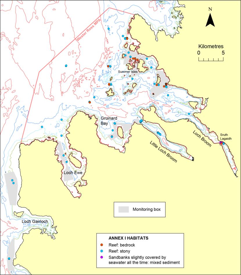
Figure 51. Distribution of Annex I habitat records off Wester Ross.
Click for a full description
Map of the distribution of EC Habitats Directive Annex I habitats off Wester Ross, with habitat type distinguished by different coloured circles. Also shown are the monitoring boxes (in grey), boundary of the Wester Ross MPA (in dark pink) and 20 m, 30 m, 50 m and 100 m depth contours. © Crown copyright and database rights [2024] Ordnance Survey 100017908. Bathymetry © Crown Copyright, 2020. All rights reserved. Licence No. EK001-20140401. Not to be used for navigation.
4.4.1 Sruth Lagaidh Narrows, Loch Broom (Figure 52)
Although there have been several investigations of the Sruth Lagaidh flame shell bed since its discovery in 1988 (Gubbay and Nunn, 1988), extensive survey work on this protected feature was carried out by SNH in 2010 (Moore et al. 2011) and 2017 (Moore, 2019). Although no firm evidence was available for a temporal change in bed extent between 2010 and 2017, the imagery suggested that there had been a temporal increase in turf thickness, with the turf overtopping the bound pebbles and shell in 2017 but not in 2010 (Moore, 2019). The single 2023 video run which passed through the bed precisely matched the eastern and western habitat boundaries identified in 2017 (Figure 52). The well-developed sand/turf mosaic with a thick turf penetrated by dense gallery apertures observed in 2017 was also present in 2023 and turf cover estimates were similar (70%, locally 100%). The 2023 observations might suggest that the western, down-loch margin of the bed did not extend as far west as the 2010 habitat polygon shown in Figure 52, but this could result from an absence of historical records in the relevant area. In summary, there is no indication of a change in extent or condition of the bed between 2017 and 2023, but there appears to have been an enhancement of turf thickness between 2010 and 2017.
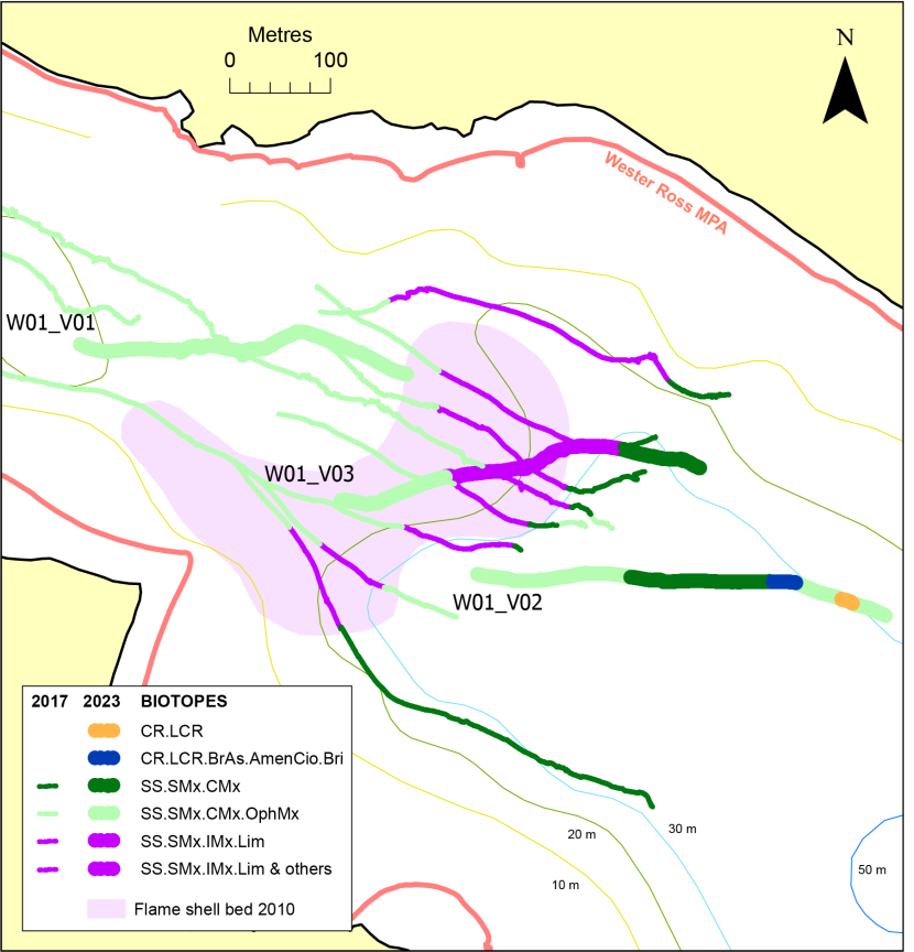
Figure 52. Comparison of 2023 biotope records in Sruth Lagaidh Narrows, Loch Broom with those of earlier surveys.
Click for a full description
Comparison of biotope records from 2023 with those from 2017 and 2010 mapping of the flame shell bed. 2023 biotopes shown as different coloured tracks, 2017 records as thin lines using same coloration scheme and the 2010 bed mapping in lilac. Also shown are 2023 video run labels, the 10 m, 20 m, 30 m and 50 m depth contours and the boundary of the Wester Ross MPA (in dark pink). © Crown copyright and database rights [2024] Ordnance Survey 100017908. Bathymetry © Crown Copyright, 2020. All rights reserved. Licence No. EK001-20140401. Not to be used for navigation.
4.4.2 Little Loch Broom (Figure 53)
Aggregations of Leptometra celtica on mixed substrata, a protected feature of the Wester Ross MPA, were recorded at seven locations along four of the video runs on the outer and mid-loch sills of Little Loch Broom (Figure 53, Table 2). GeMS mapping of this feature on the outer sill (Figure 53) is based on SNH surveys in 2010 (Moore et al., 2011), 2011 (Moore, 2012) and 2017 (Moore 2019). Where the feature was present Leptometra density was mostly similar to previous SACFOR records (i.e. abundant). There appears to have been some temporal change in the distribution of the feature here, although there is no indication of a decrease in extent. In particular in 2023 the feature extended 100 m eastward of the northern 2017 boundary. Such changes are not surprising in such a highly motile species.
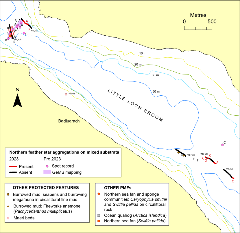
Figure 53. Distribution of protected feature and other PMF records in Little Loch Broom and temporal comparison of records of northern feather star aggregations on mixed substrata.
Click for a full description
Map of the outer region of Little Loch Broom showing distribution of 2023 records of protected features and other PMFs. Most PMFs shown as symbols marking the centre of the video sample. For northern feather star aggregations the presence or absence along runs is indicated by red or black coloration of the video track, with SACFOR abundance of Leptometra celtica (northern feather star) in red text. Pre 2023 records of aggregations are indicated by cyan circle symbols and polygon mapping of the aggregations (in lilac) based on 2010 and 2017 surveys. Pre 2023 SACFOR abundances of L. celtica are shown in black text, as are video run labels. © Crown copyright and database rights [2024] Ordnance Survey 100017908. Bathymetry © Crown Copyright, 2020. All rights reserved. Licence No. EK001-20140401. Not to be used for navigation.
The species Leptometra celtica, a PMF, was recorded at an additional four sites in the loch at low density. Other PMFs observed at low frequency during the May 2023 video survey included burrowed mud, Pachycerianthus multiplicatus, northern sea fan and sponge communities, Callistephanus pallida and Arctica islandica.
The 2023 dive survey included examination of a 25 m long transect through a maerl bed off Badluarach, which had previously been surveyed in 2010 (Moore et al., 2011). Community composition of the bed appears similar in both years, although there is a temporal discrepancy in live maerl density, with live maerl reported as 75% in 2010 and 45% in 2023. Comparison of the imagery from both years is suggestive of a real temporal decrease in live maerl cover (Figure 54).
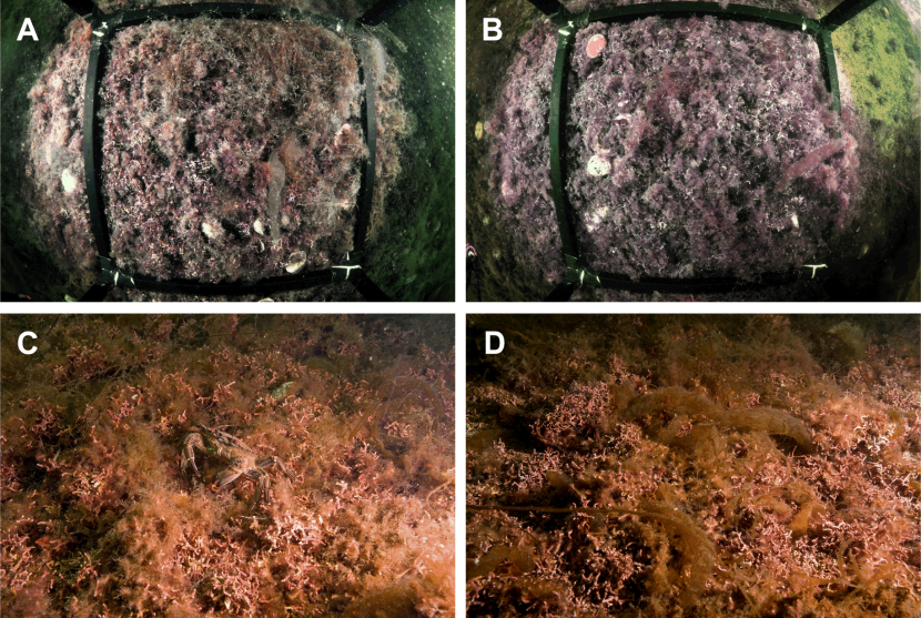
Figure 54. Photographs of maerl bed at site WER01, Little Loch Broom in 2023 (A, B) and 2010 (C, D).
Click for a full description
Photographs taken along transect through a maerl bed at site WER01, Little Loch Broom. A and B: randomly positioned 50 x 50 cm quadrat during 2023 dive survey. C and D: wide-angle views of habitat during 2010 dive survey at same location.
4.4.3 Gruinard Bay (Figure 55)
Gruinard Bay contained examples of the MPA protected features burrowed mud and maerl beds (Figure 55, Table 2). In addition to the presence of the burrowed mud habitat at five locations, the burrowed mud component species, F. quadrangularis, was recorded at one site. Although only a single specimen was observed, this would appear to be the first sighting of the species in Gruinard Bay according to the GeMS database v10.i28 (Scottish Government, 2024). However, coverage of the deeper regions of the bay by previous surveys has been minor. Maerl beds were recorded along five of the video runs in 2023 and along a single 2023 diver transect to the northeast of Gruinard Island (WER02). Live maerl cover estimates in 2023 were generally similar to those observed at nearby locations in previous years (Figure 55). Along 2023 run W06_V01 to the south-west of Gruinard Island the bed was composed principally of dead maerl, with live thalli reaching a maximum cover of 15% (frequent) over a depth range of 25 - 29 m. A nearby 2010 maerl site exhibited denser live maerl (common) but the depth was significantly shallower (19 - 20 m). The site of the 2023 maerl dive transect has not been examined previously. Nearby historical maerl bed survey sites exhibited similar live maerl densities (all frequent), but they were all over 200 m distant.
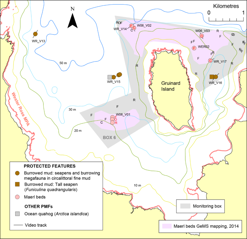
Figure 55. Distribution of protected feature and other PMF records in Gruinard Bay
Click for a full description
Map of Gruinard Bay showing distribution of 2023 records of protected features and other PMFs. Features shown as symbols marking the centre of the video sample, with track indicated by black line. SACFOR density of live maerl shown in red text for 2023 survey and in black text for previous surveys. Also shown is 2014 polygon mapping of maerl beds in pink (GeMS, 2024), video run labels, monitoring box 6 in grey and the boundary of the Wester Ross MPA in dark pink. © Crown copyright and database rights [2024] Ordnance Survey 100017908. Bathymetry © Crown Copyright, 2020. All rights reserved. Licence No. EK001-20140401. Not to be used for navigation.
The PMF Arctica islandica was recorded for the first time in Gruinard Bay in an area of burrowed mud to the west of Gruinard Island (WR_V15). Siphon density was noted as being occasional, locally frequent.
4.4.4 Loch Ewe to Loch Gairloch (Figure 56)
Protected Features observed within Loch Ewe included two examples of circalittoral muddy sand communities, eight examples of burrowed mud, including one with Funiculina quadrangularis, and two instances of kelp and seaweed communities on sublittoral sediment (Figure 56). The PMF Arctica islandica was also observed along four of the video run sectors at densities up to occasional. The eight video runs west of Loch Ewe traversed three PF habitats: circalittoral muddy sand communities along two runs, maerl beds along four runs, and maerl or coarse shell gravel with burrowing sea cucumbers along one run. Dense live maerl (up to 60% cover locally) was recorded at one location. Sparse sandeels (a PMF) were observed along two of these runs.
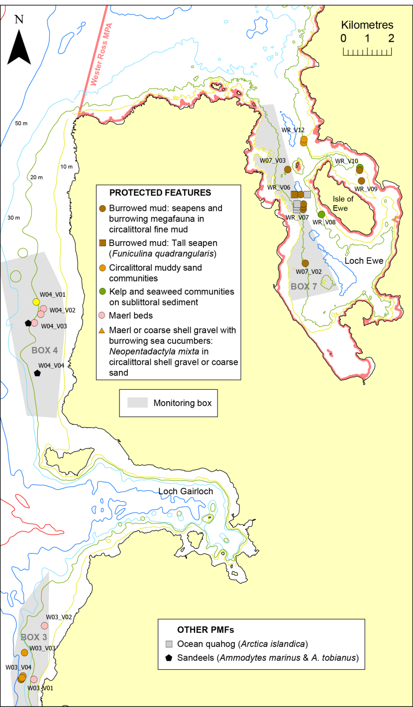
Figure 56. Distribution of protected feature and other PMF records from Loch Ewe to Loch Gairloch.
Click for a full description
Map of Wester Ross coastline from Loch Ewe to Loch Gairloch showing distribution of 2023 records of protected features and other PMFs. Features shown as symbols marking the centre of the video sample, with short tracklines obscured by symbols. Also shown are video run labels, monitoring boxes 3, 4 and 7 in grey and the boundary of the Wester Ross MPA in dark pink. © Crown copyright and database rights [2024] Ordnance Survey 100017908. Bathymetry © Crown Copyright, 2020. All rights reserved. Licence No. EK001-20140401. Not to be used for navigation
Maerl has been widely recorded historically along the coastline adjacent to Loch Gairloch, both to the north and south, but only a single historical maerl bed record (Moore et al., 2011) lies within 1 km of the 2023 records north of Loch Gairloch, being c.400 m inshore of 2023 run W04_V02. Live maerl cover was estimated as common overall in both years. Historical site density is higher south of Loch Gairloch, with one 2004 record located around 600 m south of the 2023 maerl sites at a similar depth (Moore and Atkinson, 2012). Abundant live maerl (50%) was reported along the 2004 run, which compares to 5%, locally 20%, along the nearest 2023 site. However, five 2019 Marine Scotland video runs were located between the two 2023 maerl bed records, W03_V01 and W03_V02, mostly of similar depth and approaching to within 100 m of one of them. Only two of these were recorded as maerl beds (live maerl cover unknown), with the three others ascribed to SS.SCS.CCS.Nmix. Clearly maerl is patchy in this region and no temporal change in maerl bed condition here can be inferred.
Within Loch Ewe run WR_V08 approached to within 130 m of a 2010 maerl bed record (Moore et al., 2011), when live maerl was estimated as common in patches. No maerl was observed along WR_V08 in 2023, but the depth was significantly greater (17 - 22 m in 2023, 9 - 10 m in 2010). No distinct temporal change in other biotopes or biotope condition could be identified within the Loch Ewe to Loch Gairloch region.
4.4.5 Mouth of Loch Broom to Horse Island (Figures 57, 58)
Examples of four protected feature habitats (also PMFs) were recorded in this region of the MPA. Four burrowed mud records included two where the burrowed mud component species Funiculina quadrangularis was also present. Beds of fairly low coverage live maerl were observed south of Horse Island and around the Carn Skerries, where one example of a kelp and seaweed community on sublittoral sediment was also noted. Similar levels of live maerl were observed in these locations during surveys in 2016 (see Moore, 2019) and 2010 (Moore et al., 2011).
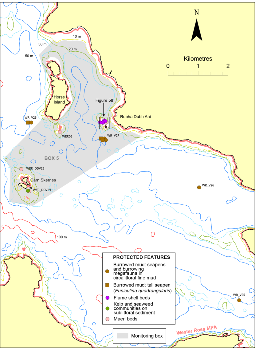
Figure 57. Distribution of protected features from the mouth of Loch Broom to Horse Island.
Click for a full description
Map of Wester Ross coastline from the mouth of Loch Broom to Horse Island showing distribution of protected features as symbols differing in colour and shape with video run labels labels. The short tracklines are obscured by the symbols. Also shown is monitoring box 5 in grey and the boundary of the Wester Ross MPA in dark pink. Black rectangle off Rubha Dubh Ard shows extent of greater detail coverage provided in Figure 58. © Crown copyright and database rights [2024] Ordnance Survey 100017908. Bathymetry © Crown Copyright, 2020. All rights reserved. Licence No. EK001-20140401. Not to be used for navigation.
The 2023 survey work has extended to the north-east the known distribution of overlapping maerl and flame shell beds between Mary Rock and Iolla Bheag off Rubha Dubh Ard (Figure 58). The maerl here was bound by filamentous red algae and in part by Limaria byssal material, making delineation of byssal turf coverage and the extent of the flame shell bed difficult to determine. Live maerl cover was generally high in 2023 (mostly common), similar to levels recorded during a 2016 survey by Sea Change Wester Ross/SubSea TV (see Moore, 2019). Abundant live maerl was present along a Blue Hope Alliance maerl monitoring transect in 2019 (Blue Hope Alliance, 2024). This higher density perhaps reflects spatial patchiness seen elsewhere on this bed in 2023, rather than being an indication of a temporal trend. The flame shell habitat was not well-developed here and did not form a continuous or sharply delineated, mosaicked byssal turf with sediment. Rather, it presented as clumped maerl or fairly diffuse, algal turf patches reaching up to around 33% cover.
Figure 58. Comparison of records of protected feature biotopes west of Rubha Dubh Ard (‘Planet Rock’) with those of earlier surveys.
Click for a full description
Map showing distribution of protected feature biotope records off Rubha Dubh Ard, colloquially known as ‘Planet Rock’. Records include those for the 2023 survey and earlier surveys. See box in Figure 57 for location. Video tracks are coloured according to biotope and similarly coloured circle symbols denote the biotope midpoint. Red alphabetical text indicates 2023 live maerl SACFOR abundance, with red numerical text representing percentage cover of flame shell habitat In addition to signifying 2023 video run labels, black text shows pre-2023 live maerl SACFOR abundance, with localised abundance in brackets. Also shown are the 10 m and 20 m depth contours. © Crown copyright and database rights [2024] Ordnance Survey 100017908. Bathymetry © Crown Copyright, 2020. All rights reserved. Licence No. EK001-20140401. Not to be used for navigation.
4.4.6 Summer Isles and adjacent waters to the west (Figures 59, 60)
This region of the Wester Ross MPA contained the greatest number and diversity of records of protected features and other PMFs, most of which were sedimentary habitats. The protected feature PMFs included burrowed mud, which was widely distributed in deeper waters beyond the 50 m depth contour. The habitat included the burrowed mud component species Funiculina quadrangularis at four of the deeper sites and occasional Pachycerianthus multiplicatus at one of them. Circalittoral muddy sand communities were recorded along four widely-separated video runs. Scattered stones on sandy mud at one location (WR_V43) supported a field of Leptometra celtica, representing the PF ‘aggregations of northern feather star on mixed substrata’. Examples of kelp and seaweed communities on sublittoral sediment were observed off Cailleach Head at the mouth of Little Loch Broom and in Dorney Sound north of Tanera More, with a monitoring dive transect established at one of them (WER04). Maerl beds were also recorded at the same Cailleach Head site, where live maerl was generally at low density but possibly common in patches, and at the mouth of Mol Mòr Bay, south-west Tanera More, where live maerl was common. This latter site was also examined by means of a dive transect (WER03).
Figure 59. Distribution of protected feature and other PMF records around the Summer Isles and adjacent waters to the west.
Click for a full description
Map of the Summer Isles and adjacent western waters showing distribution of 2023 records of protected features and other PMFs. Features shown as symbols marking the centre of the video sample, with video run labels and black tracklines (obscured by symbols in the case of short tracks). Also shown is monitoring box 2 in grey and the boundary of the Wester Ross MPA in dark pink. © Crown copyright and database rights [2024] Ordnance Survey 100017908. Bathymetry © Crown Copyright, 2020. All rights reserved. Licence No. EK001-20140401. Not to be used for navigation.
Other non-protected feature PMFs recorded in the area included northern sea fan and sponge communities along four of the video runs, with three representing deep sponge communities and one with Caryophyllia smithii and Callistephanus pallida. Arctica islandica siphons were observed along one run and kelp beds were recorded along two runs in Dorney Sound and one off Rubha Mór.
The dive monitoring site WER04 was located in an area that has been subjected to repeated dredging (Sea Change Wester Ross, 2021). A 2016 diver video run by Sea Change Wester Ross/Subsea TV passed through the area in 2016 (see Moore 2019). The camera angle was considered unsuitable for the identification of live maerl, but coverage possibly attained 10% (frequent) in small patches. On this basis a section of the video run was assigned to a maerl bed biotope, although overall live coverage was rare. The 2023 dive transect WER04 passed within a few metres of the 2016 run, with a very similar substrate and biota being recorded. Overall live maerl cover estimates in 2023 were rare based on both video analysis and in situ diver recording, although one of the six in situ diver maerl estimates taken along the transect attained 10% (frequent). In 2023 the area was tentatively assigned to the biotope SS.SMp.KSwSS.SlatR.Gv based on the presence of a gravelly, coarse sand substrate supporting a red algal turf with sparse Saccharina latissima, but there is no indication that significant temporal change has occurred to the habitat between 2016 and 2023. A higher level of live maerl (common) was recorded along run MB67 in 2010 (Moore et al., 2011), but this site was located around 80 m away and so any difference may be indicative of spatial patchiness rather than temporal change.
The Tanera More maerl bed dive monitoring site WER03 closely matched the position of a 2010 dive transect, ML02 (Moore et al., 2011). In 2023 the maerl bed exhibited a flat topography with a veneer of maerl material on silty sand, of which around 20% was exposed (Figure 60). In 2010 the seabed was topographically varied, with maerl gravel forming low waves lacking pronounced crests or troughs, and there was little visual evidence of an underlying sand stratum. Live maerl coverage in 2023 was estimated at around 25% but much of it was covered with a superabundant, short, filamentous red algal turf rendering accurate density estimation very difficult (Figure 60). In 2010 the dominant alga (recorded as common) was the larger, non-filamentous, gametangial phase of Bonnemaisonia asparagoides, with much of the live maerl thalli exhibiting little epibiotic fouling (Figure 60). Diver estimation of live maerl cover in 2010 was 40%, although re-examination of the video footage taken suggests a lower level of perhaps around 30%. The difference in live maerl estimates between the surveys lies within the margin of error. Thus, temporal change in at least the topography, substrate composition and the algal flora has taken place at this site and there has possibly been a reduction in live maerl density. It is likely that natural change in the level of hydrodynamic activity represents at least in part a causative factor.
Figure 60. Photographs of maerl bed at site WER03, Tanera More, Summer Isles in 2023 (A, B) and 2010 (C, D).
Click for a full description
Photographs taken along transect through a maerl bed at site WER03, at the mouth of Mol Mòr Bay, Tanera More, Summer Isles. A and B: within randomly positioned 50 x 50 cm quadrats during 2023 dive survey. C and D: wide-angle views of habitat during 2010 dive survey at same location.
Several of the 2023 video runs were in the proximity of historical records of burrowed mud from surveys in 2010 - 2013. Similar densities of megafaunal burrowers and sea pens including Funiculina quadrangularis were observed in both survey periods.
4.5 Loch Eriboll
Rocky reef Annex I habitats were widespread in Loch Eriboll, being recorded at 73 of the 217 sites examined (Table 3, Figure 61). Bedrock and stony subtypes were roughly equally represented, although rock type was not discernible in a significant proportion of records (11). Most records were located above the 30 m depth contour, although stony reef records extended to a depth of 68 m.
Figure 61. Distribution of Annex I habitat records in Loch Eriboll.
Click for a full description
Map of the distribution of EC Habitats Directive Annex I habitats in Loch Eriboll, with habitat type distinguished by different coloured circles. Also shown are the 20 m, 30 m, 50 m and 100 m depth contours. © Crown copyright and database rights [2024] Ordnance Survey 100017908. Bathymetry © Crown Copyright, 2020. All rights reserved. Licence No. EK001-20140401. Not to be used for navigation.
Five habitat PMFs (representing nine biotopes) and two species PMFs were identified (Figure 62, Table 2). Burrowed mud appeared to be the dominant habitat in a large part of the inner loch between Eilean Choraidh and Sgeir a’ Bhuic, with a trend of Maxmuelleria mounded mud giving way to mud with seapens and burrowing megafauna with progression northwards down the loch. The inner loch was also notable for the high frequency of records of kelp and seaweed communities on sublittoral sediment in shallower, coastal waters. A single example of submerged fucoids in low or variable salinity was recorded in a stream running over the shore at the head of the loch. Kelp bed PMF biotopes were recorded at 16 locations in the outer part of the loch beyond Sgeir a’ Bhuic, largely as the kelp forest biotope IR.MIR.KR.Lhyp.Ft and, where substrate visibility was severely curtailed, IR.MIR.KR.Lhyp.
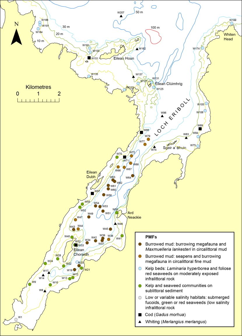
Figure 62. Distribution of PMF records in Loch Eriboll
Click for a full description
Map of Loch Eriboll showing distribution of PMFs as symbols of differing shape and colour with site labels. © Crown copyright and database rights [2024] Ordnance Survey 100017908. Bathymetry © Crown Copyright, 2020. All rights reserved. Licence No. EK001-20140401. Not to be used for navigation.
The baited SBRUV sampling technique was particularly effective at recording imagery of scavenger species, including juvenile gadoids. Two PMF gadoid species were widely recorded: cod at eight sites and whiting at seventeen sites. Both species were probably present at a significant number of additional sites, but inadequate image quality precluded firm identification.
It should be noted that the same set of 2021 SBRUV imagery samples employed in the current study were also examined by Burns, Bailey and Hopkins (2024) as part of an attempt to produce a predictive seabed substrate map for Loch Eriboll, although all video footage was analysed, rather than the 15 second clips that were used in the current study. As part of this work Burns, Bailey and Hopkins (2024) allocated all SBRUV video samples to one of six substrate classes: rock, cobble and boulder, gravel, sand, muddy sand and mud. The only significant discrepancy between the two studies is the more extensive coverage of muddy sand reported by Burns, Bailey and Hopkins (2024). This resulted from them allocating sites in much of the eastern, outer region of the loch to muddy sand. This area appeared to be composed of slightly rippled or dimpled fine sand with a minor mud content and has been largely assigned to the fine sand biotope SS.SSa.CFiSa in the current study. More comprehensive information on substrate and infaunal composition from grab sampling would be necessary to aid confirmation of the biotope.
Previous surveys in 2011 and 2012 by SNH/Marine Scotland Science (Moore, 2012; Moore and Atkinson, 2012) established the widespread presence of burrowed mud in the inner loch, although the only biotope recorded was SS.SMu.CFiMu.SpnMeg. The present 2021 study found the predominant burrowed mud habitat in a fairly extensive region of the inner loch to be SS.SMu.CFiMu.MegMax. Both biotopes were recorded in the same area of the loch by a 2019 survey (Burns, Hopkins and Bailey, 2020) and so it is possible that there has been recent development of the spoon worm population (Maxmuelleria lankesteri), whose mounds characterise the latter biotope.
There are two old historical records of maerl beds in Loch Eriboll, both derived from Seasearch surveys in 1986 west of Eilean Choraidh and west of Ard Neackie, where maerl density was assessed as frequent and common respectively. Maerl biotopes were recorded at an additional 11 sites west and north-east of Eilean Choraidh by a 2019 diving survey (Burns, Hopkins and Bailey, 2020). However, maerl density was assessed as either rare or occasional at all of these sites, so the basis on which they were referred to maerl biotopes is uncertain. Only one of the 2021 SBRUV sample sites was located close to previous maerl records, W27, which was 25 m from the west Eilean Choraidh 1988 Seasearch record. The positional accuracy of such records before the widespread civilian use of GPS and the discontinuation of Selective Availability is often poor and indeed the 2021 imagery revealed a totally different habitat in the form of a kelp forest. No evidence for any change in the status of maerl beds in the loch is available.
5 References
Blue Hope Alliance. 2024. 2019/09/23 Planet Rock Maerl Transect. Blue Hope Alliance.
Burns, N.M., Bailey, D.M. and Hopkins, C.R. 2024. Predictive GAM seabed maps can account for defined and fuzzy boundaries to improve accuracy in a Scottish sea loch seascape. DOI:10.31219/osf.io/sfamb
Burns, N.M., Hopkins, C.R. and Bailey, D.M. 2020. Loch Eriboll Priority Marine Feature Review of 2020. DOI:10.13140/RG.2.2.23636.83843
COAST. 2020. Extraordinary Flame Shell discovery in South Arran MPA.
Connor, D.W., Allen, J.H., Golding, N., Howell, K.L., Lieberknecht, L.M., Northen, K.O. and Reker, J.B. 2004. The National Marine Habitat Classification for Britain and Ireland. Version 04.05. Peterborough: Joint Nature Conservation Committee.
Doggett, M., Morris-Webb, L. and Baldock, L. 2024. Time series analysis to determine change in maerl beds. NatureScot Research Report No.1275.
European Commission, 2013. Interpretation Manual of European Union Habitats. EUR 28.
Gubbay, S. and Nunn, J. 1988. Seasearch survey of Loch Broom and Little Loch Broom. Nature Conservancy Council CSD Report No. 898.
Hiscock, K. ed. 1996. Marine Nature Conservation Review: Rationale and Methods. Peterborough: Joint Nature Conservation Committee.
Mercer, T., Kamphausen, L., Moore, J., Bunker, F., Archer Thompson, J. and Howson, C. 2018. South Arran MPA diver survey of maerl beds, kelp and seaweed communities on sublittoral sediment, and seagrass beds 2014. Scottish Natural Heritage Research Report No. 882.
Moore, C.G. 2012. An assessment of the conservation importance of benthic epifaunal species and habitats identified during a series of research cruises around NW Scotland and Shetland in 2011. Scottish Natural Heritage Commissioned Report No. 507.
Moore, C.G. 2019. Biological analyses of underwater video from monitoring and research cruises in Lochs Ailort and Fyne, the Sounds of Barra and Mull, inner Moray Firth, off Wester Ross, Noss Head and Rattray Head, and around the Southern Trench in outer Moray Firth. Scottish Natural Heritage Research Report No. 1085.
Moore, C.G. 2020. Biological analyses of underwater video from monitoring and research cruises carried out from 2017 to 2019 in the Sounds of Barra and Mull, Lochs Sunart, Alsh and Carron, the Inner Sound, and off the Small Isles and east of Shetland. NatureScot Research Report No. 1229.
Moore, C.G. 2021. Biological analyses of underwater video footage collected from around the Isle of Arran (Firth of Clyde) in 2015. NatureScot Research Report 1265.
Moore, C.G. and Atkinson, R.J.A. 2012. Biological analyses of underwater video from research cruises in the Clyde Sea, Loch Torridon and the Inner Sound, the North Minch, Loch Eriboll and off Orkney. Scottish Natural Heritage Commissioned Report No. 536.
Moore, C.G., Harries, D.B., James, B., Cook, R.L., Saunders, G.R, Tulbure, K.W., Harbour, R.P. and Kamphausen, L. 2018. The distribution and condition of flame shell beds and other Priority Marine Features in Loch Carron Marine Protected Area and adjacent waters. Scottish Natural Heritage Research Report No. 1038.
Moore, C.G., Harries, D.B., Trigg, C., Porter, J.S. and Lyndon, A.R. 2011. The distribution of Priority Marine Features and MPA search features within the Ullapool Approaches: a broadscale validation survey. Scottish Natural Heritage Commissioned Report No. 422.
NatureScot. 2024. Priority marine features in Scotland's seas.
Scottish Government. 2013. Scottish Biodiversity List.
Scottish Government. 2024. GeMS - Scottish Priority Marine Features (PMF). SpatialData.gov.scot
Scottish Natural Heritage. 2018. Priority Marine Feature (PMF) - Fisheries Management Review. Maerl beds.
Scottish Natural Heritage and Marine Scotland Science. 2017. Seabed habitats survey - 3-5 May, 2017, Loch Carron. Field Report, diver and drop-down video survey.
Sea Change Wester Ross. 2021. The Blue Hope Alliance - eyes under water in the north west. Sea Change Wester Ross.
Annexes
| MPA | Protected feature | Component name | Component biotope code/species name |
|---|---|---|---|
| South Arran, Wester Ross | Burrowed mud | Burrowing megafauna and Maxmuelleria lankesteri in circalittoral mud | SS.SMu.CFiMu.MegMax |
| South Arran, Wester Ross | Burrowed mud | Seapens and burrowing megafauna in circalittoral fine mud | SS.SMu.CFiMu.SpnMeg |
| South Arran, Wester Ross | Burrowed mud | Fireworks anemone | Pachycerianthus multiplicatus |
| South Arran, Wester Ross | Burrowed mud | Tall seapen | Funiculina quadrangularis |
| Wester Ross | Circalittoral muddy sand communities | Circalittoral muddy sand | SS.SSa.CMuSa |
| Loch Carron, Wester Ross | Flame shell beds | Limaria hians beds in tide-swept sublittoral muddy mixed sediment | SS.SMx.IMx.Lim |
| South Arran, Wester Ross | Kelp and seaweed communities on sublittoral sediment | Kelp and seaweed communities on sublittoral sediment | SS.SMp.KSwSS |
| South Arran, Loch Carron, Wester Ross | Maerl beds | Maerl beds | SS.SMp.Mrl |
| South Arran, Wester Ross | Maerl or coarse shell gravel with burrowing sea cucumbers | Neopentadactyla mixta in circalittoral shell gravel or coarse sand | SS.SCS.CCS.Nmix |
| Wester Ross | Northern feather star aggregations on mixed substrata | n/a | Leptometra celtica |
| South Arran | Ocean quahog aggregations | n/a | Arctica islandica |
| South Arran | Seagrass beds | Zostera marina/angustifolia beds on infralittoral clean or muddy sand | SS.SMp.SSgr.Zmar |
| South Arran | Tide-swept coarse sands with burrowing bivalves | Moerella spp. with venerid bivalves in infralittoral gravelly sand | SS.SCS.ICS.MoeVen |
| Clyde Sea Sill | Circalittoral and offshore sand and coarse sediment communities | Circalittoral fine sand | SS.SSa.CFiSa |
| Clyde Sea Sill | Circalittoral and offshore sand and coarse sediment communities | Circalittoral coarse sediment | SS.SCS.CCS |
| Clyde Sea Sill | Circalittoral and offshore sand and coarse sediment communities | Offshore circalittoral sand | SS.SSa.OSa |
| Clyde Sea Sill | Circalittoral and offshore sand and coarse sediment communities | Offshore circalittoral coarse sediment | SS.SCS.OCS |
| Clyde Sea Sill | Black guillemot | n/a | Cepphus grylle |
| Qualifying Annex I habitats | Annex I sub-types/features | Biotopes |
|---|---|---|
| Reefs | Bedrock | IR, LR and CR biotopes on bedrock |
| Reefs | Stony | IR, LR and CR biotopes on stable boulders and cobbles (>10% cover) elevated from seabed by at least several cm and covering area >25 m2 |
| Subtidal sandbanks | Gravelly & clean sands | SS.SCS (excluding .OCS), SS.SSa (excluding SS.SSa.IFiSa.TbAmPo, .IMuSa, .CMuSa. & .OSa) |
| Subtidal sandbanks | Kelp & seaweed | SS.SMp.KSwSS (excluding .Tra & .FilG) |
| Subtidal sandbanks | Maerl beds | SS.SMp.Mrl + child biotopes |
| Subtidal sandbanks | Muddy sands | SS.SSa.IMuSa, SS.SSa.CMuSa & SS.SSa.IFiSa.TbAmPo |
| Subtidal sandbanks | Mixed sediments | SS.SMx (excluding .SMxLS & .OMx) |
| Subtidal sandbanks | Seagrass beds | SS.SMp.SSgr [subtidal] |
Annex 3 – Survey Data (Microsoft Excel .xlsx file)
This annex provides all survey data for all eleven surveys covered by this study. The spreadsheet rows are ordered by survey. For most surveys each row corresponds to a video sample. At each survey site a video run is composed of one or more samples, each sample representing a biotope or in some cases a biotope mosaic. The site or run name takes the form of XXX, with associated samples also given as XXX, or if segmented as XXX.XX where the suffix.is the sample number. For the 2021 South Arran BACI stills survey, where the run at each site is composed of a transect of 5 stills, a similar naming convention has been used taking the form ARRXX_YY, where XX is the monitoring box number and YY is the site number within the box. Very few of these photo runs have been split into segments of different biotopes carrying a numeric suffix.
For each video or stills sample positional, temporal and depth data are given, as well as physical and biological descriptions of the benthic habitat, the latter including SACFOR abundances of the taxa. The letter P is used to represent presence of a taxon. Temporal data includes date, UT time at start and end of sample and, for video samples, the timecode at the start and end of the HD footage. Latitude and longitude coordinates (in WGS84) and depth (following correction for the tidal rise) are provided, as well as biotopes and the presence of Habitats Directive Annex I features, protected features and PMFs. Uncertain biotopes are given in italics.