NatureScot Research Report 1278 - Monitoring the success of Peatland Action - establishing a baseline condition for vegetation
Year of publication: 2022
Authors: Ross, S. and Blackshaw, A.
Cite as: Ross, S. and Blackshaw, A. 2022. Monitoring the success of Peatland Action – establishing a baseline condition for vegetation. NatureScot Research Report 1278.
Keywords
peatland; vegetation; restoration; monitoring; blanket bog; raised bog
Background
Peatland Action has funded habitat restoration and management measures on a variety of peatland sites across Scotland. This project aims to establish the baseline condition of a selection of these sites to enable future long-term monitoring of the effects of the management and restoration measures applied. Site selection included both raised bog and blanket bog, encompassing a range of bog vegetation types and restoration approaches. Sites were located in both upland and lowland areas and in a wide geographical distribution across Scotland.
This report presents the results of baseline surveys of all sites which were completed between June 2014 and October 2015. Surveyors selected between three and six separate sample plots on each site to include the range of management interventions applied. Sampling within each plot was representative of either the pre-treatment baseline conditions or post-treatment conditions (up to approximately nine months after treatment). Where possible, untreated ‘control’ and unmodified ‘reference’ plots were sampled, to provide additional comparators for future assessments.
Main findings
- Six management treatments, or combinations of treatments, were sampled: re-profiling and re-turfing, re-profiling and mulch application, blocking of drains by various methods, clearance of plantation and woodland by forestry mulching, clearance of woodland and scrub by conventional felling and peat bunding.
- Samples of drain blocking treatments accounted for approximately 28% of the total dataset, with peat dams the most popular form of this treatment.
- Clearance of woodland and scrub by conventional felling accounted for 16% of samples and mulching of plantation and woodland by forestry methods accounted for 12% of samples.
- Re-profiling and turfing of haggs and gullies accounted for 13% of samples, whereas mulching of bare peat with donor material (such as heather brash), either with or without re-profiling accounted for 10% of samples. Peat bunding was carried out on a single site.
- In addition to the ‘capital works’, treatments included the manipulation of management regimes. This was undertaken at only one site, Moine Mhor, where grazing and burning targeted to control purple moor-grass had been trialled.
- The majority of datasets were collected at the post-treatment stage, but this was not considered a major limitation as datasets were generally collected prior to the effects of treatments being detectable. Similarly, it was not possible to systematically record control plots at each restoration site because often an entire site had been subject to restoration measures. The majority of datasets collected during the project are considered to effectively represent the baseline states of the sample plots. Therefore gross positive changes, such as a reduction in bare peat within a plot that sampled re-profiled and re-turfed haggs or an increase in Sphagnum species in a plot subjected to drain blocking could be attributed to the treatments with a high degree of confidence.
- Reference plots were also recorded where possible, to provide a proxy for the target vegetation type for the restored areas. The reference plots were considered to be particularly appropriate on sites with low level degradation, such as from light gripping, as they will aid interpretation of subtle changes in the vegetation allowing conclusions to be drawn on whether vegetation within the corresponding restored plots is improving towards the target community, or changing on a different trajectory. Reference plots will also be valuable in detecting and quantifying negative changes through external factors, such as fire, which may affect the restoration sites.
- Finally, the datasets collected and interventions applied have been set in the context of existing research and information on similar techniques applied to other peatland sites, to help inform and guide future restoration and monitoring effort. Where appropriate, recommendations have been given for the sites, including an appropriate monitoring period, potential issues with vegetation re-establishment (e.g. vigorous or invasive species) or technique applied (e.g. potential for dam breaches) and ways in which these might be addressed in the future.
Acknowledgements
The authors would like to thank the landowners and land managers for their assistance in arranging access to the sites and also the NatureScot Peatland Action staff for their invaluable input throughout the project.
Several members of Penny Anderson Associates were involved in the delivery of the project and the authors would like to extend their thanks to the team, in particular Anne Goodenough, Chris Chapman, Victoria Burton, Kath Longden, Helen Hamilton and Paul Fisher.
Introduction
Background to project
Penny Anderson Associates Ltd (PAA) was commissioned by NatureScot (previously known as Scottish Natural Heritage) in 2014 to complete a contract entitled ‘Monitoring the Success of Peatland Action’.
Peatland Action (previously known as the Green Stimulus Peatland Restoration Project) carries out peatland restoration across Scotland. The main objective is to reduce the amount of carbon released into the atmosphere by degraded peatlands. The project’s secondary objectives are to increase people’s enjoyment and knowledge of peatlands and to benefit peatland biodiversity. The project is funded by Scottish Government and administered by NatureScot.
Aims of survey
Peatland Action has funded habitat restoration and management measures on a variety of peatland sites across Scotland. This project aims to establish the baseline condition of a selection of these sites to enable future long-term monitoring of the effects of the management and restoration measures applied.
The sites for monitoring were selected from those that have received Peatland Action funding, and those where restoration is likely in the future. Selection of the sites was completed by NatureScot with the aim of including both raised bog and blanket bog, encompassing a range of National Vegetation Classification (NVC) communities (Rodwell 1991). The NVC communities sampled included the main bog communities described for Britain, namely M17, M18 and M19. Sites were located in both upland and lowland areas and in a wide geographical distribution across Scotland. A broad range of restoration techniques were also included.
M17 - Trichophorum germanicum - Eriophorum vaginatum blanket mire
M18 - Erica tetralix - Sphagnum papillosum raised and blanket mire
M19 - Calluna vulgaris - Eriophorum vaginatum blanket mire
The monitoring project was carried out across two years and included 16 sites in total. The first tranche of six sites was selected and surveyed in summer 2014. A second tranche of seven sites was selected and surveyed in summer 2015. A third tranche of three sites was selected for survey in late summer/autumn 2015.
This report presents the results of baseline surveys of all sites which were completed between June 2014 and October 2015 (Figure 1). Surveyors selected between three and six separate sample plots on each site to include the range of management interventions applied. Sampling within each plot was representative of either the pre-treatment baseline conditions or post-treatment conditions (up to approximately nine months after treatment). Where possible, untreated ‘control’ and unmodified ‘reference’ plots were sampled, to provide additional comparators for future assessments.
Sites selected
A total of 9 blanket bog sites and seven raised bog sites were selected for survey between June 2014 and October 2015 (Tables 1 and 2).
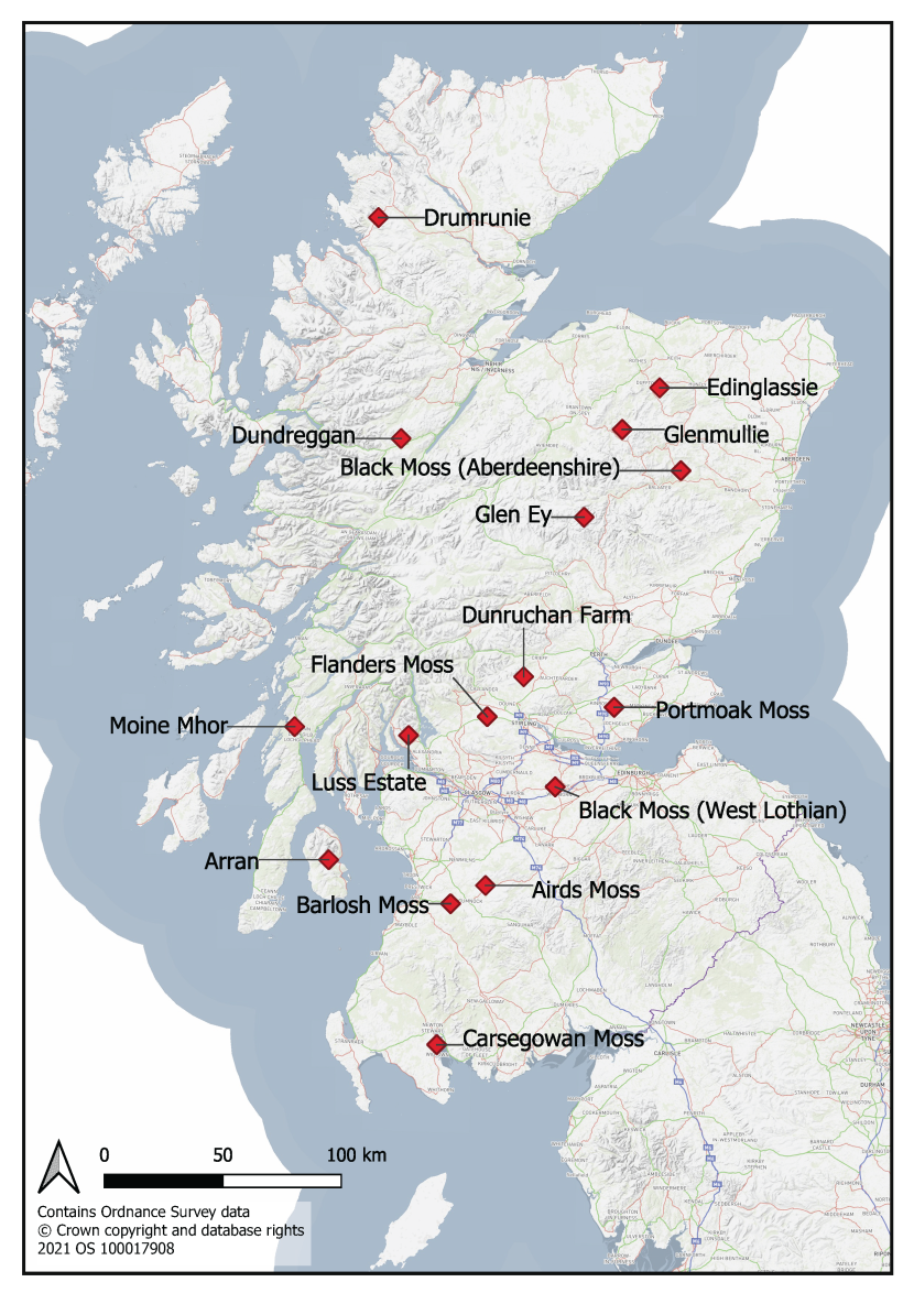
Figure 1. Overview of the locations of the 16 sites monitored during 2014 and 2015
Table 1. Blanket bog sites surveyed during the ‘Monitoring the Success of Peatland Action’ project
|
Year |
Tranche |
Site Name |
Grid Reference |
NatureScot Area |
|---|---|---|---|---|
|
2014 |
I |
Airds Moss |
NS 63000 25000 |
Stratchclyde & Ayrshire |
|
2014 |
I |
Drumrunie |
NC 18000 08000 |
South Highland |
|
2015 |
II |
Dundreggan |
NH 28900 14700 |
South Highland |
|
2015 |
II |
Edinglassie |
NJ 36900 36100 |
Tayside and Grampian |
|
2015 |
II |
Glen Ey |
NO 06100 81500 |
Tayside and Grampian |
|
2015 |
II |
Glenmullie |
NJ 20793 17993 |
Tayside and Grampian |
|
2015 |
III |
Arran - West Glensherraig and A'Chruach |
NR 97600 34700 & NR 97000 37000 |
Strathclyde & Ayrshire |
|
2015 |
III |
Dunruchan |
NN 79947 14088 |
Tayside and Grampian |
|
2015 |
III |
Luss |
NS 32100 88500 |
Argyll and the Outer Hebrides |
Table 2. Raised bog sites surveyed during the ‘Monitoring the Success of Peatland Action’ project
|
Year |
Tranche |
Site Name |
Grid Reference |
NatureScot Area |
|---|---|---|---|---|
|
2014 |
I |
Black Moss (Aberdeenshire) |
NJ 46500 01500 |
Tayside and Grampian |
|
2014 |
I |
Flanders Moss |
NS 63300 98500 |
Forth |
|
2014 |
I |
Moine Mhor |
NR 83200 93400 |
Argyll and the Outer Hebrides |
|
2014 |
I |
Portmoak Moss |
NO 17900 01400 |
Tayside and Grampian |
|
2015 |
II |
Barlosh Moss |
NS 48800 18500 |
Stratchclyde & Ayrshire |
|
2015 |
II |
Black Moss (West Lothian) |
NS 93000 68000 |
Forth |
|
2015 |
II |
Carsegowan Moss |
NX 42700 59000 |
Southern Scotland |
General approach to baseline data gathering
The aim of the monitoring was to establish baseline vegetation condition, to assess whether restoration measures were working effectively and identify any other impacts that might occur as a result of the restoration measures.
Initially a brief desk study was completed for each site to identify the main restoration measures applied on the site and the key features of interest in terms of peatland habitat, along with an assessment of OS base maps, aerial photographs any additional available information on the site (NVC maps, Sites of Special Scientific Interest citations, etc.).
The areas where different management interventions were applied were mapped, along with any drainage channels/networks and other features of interest. These maps were used to identify suitable plot locations for baseline monitoring prior to the field visits.
The monitoring approach used randomly placed 2m x 2m quadrats within each sample plot to assess the main bog vegetation. Within each quadrat the cover of all plant species was recorded, along with a number of environmental factors, including cover of bare peat and open water, presence/absence of grazing animal dung, any damage to the bryophyte layer or peat compaction. A Garmin etrex 20 GPS was used to gather a grid reference for each quadrat location. The unit typically recorded an accuracy of between 2m and 5m.
Quadrat sampling was combined with a site walkover, to describe the general character of each sample plot and to take fixed point and illustrative photographs. In addition, the plant species which best characterised each sample plot were assigned abundance codes using the ‘DAFOR’ scale (where: D = dominant; A = abundant; F = frequent; O = occasional; R = rare).
Data were collected on standard survey sheets designed specifically for the project, ensuring standardised data collection across all sites. The Survey Protocol and is presented in Annex 1.
On some sites the proposed sampling methodology was modified slightly in the field to better suit the specific site conditions and/or the restoration measurements applied. The final sampling strategy undertaken at each site is summarised in Table 3.
Table 3. Summary of the sampling strategies for the 16 sites surveyed
Blanket Bog Sites
|
No. |
Site |
Area (ha) in Management |
Restoration Measures |
Sample Areas |
Total Quadrats |
|---|---|---|---|---|---|
|
1 |
Airds Moss |
220 |
|
A) Drains blocked in 2010 (Post-treatment sample) B) Drains blocked in 2012 (Post-treatment sample) C) Drains blocked in 2014 (Post-treatment sample) |
45 quadrats (x 15 per area), 9 on drain blocks (x3 per area) |
|
2 |
Arran - West Glensherraig and A'Chruach |
100 |
|
A) Drains blocked in 2015/16 I (Pre-treatment sample) B) Drains blocked in 2015/16 II (Pre-treatment sample) C) Peat haggs re-profiled in 2015/16 I (Pre-treatment sample) D) Peat haggs re-profiled in 2015/16 II (Pre-treatment sample) E) Untreated and relatively unmodified blanket bog (Reference) |
75 quadrats (x 15 per area) |
|
3 |
Drumrunie |
334 |
|
A) Drains blocked with plastic (Post-treatment sample) B) Unblocked drains (Control) C) Drains blocked with peat (Post-treatment sample) |
45 quadrats (x 15 per Area), 10 on drain blocks (x 5 per Area) |
|
4 |
Dundreggan |
200 |
|
A) Untreated standing plantation (Control) B) Unplanted and relatively unmodified blanket bog (Reference) C) Treated former plantation on the north-facing slope of a knoll (Post-treatment sample) D) Treated former plantation on a lower-lying wetter area (Post-treatment sample) |
60 quadrats (x 15 per area) |
|
5 |
Dunruchan Farm |
55 |
|
A) Drains blocked in 2015/16 I (Pre-treatment sample) B) Untreated and relatively unmodified blanket bog (Reference) C) Drains blocked in 2015/16 II (Pre-treatment sample) |
45 quadrats (x 15 per area) |
|
6 |
Edinglassie |
117 |
|
A) Re-profiled and patched former peat cutting (Post-treatment sample) B) Mulched bare peat basin (Post-treatment sample) C) Blocked and flattened drains (Post-treatment sample) D) Unblocked gullies (Control) E) Untreated and relatively unmodified blanket bog (Reference) F) Mulched bare peat at base of former peat cutting (Post-treatment sample) |
75 quadrats (x 15 per area) + Extensive fixed point photos for Area A (no quadrats here) |
|
7 |
Glen Ey |
Section 2 of planned area complete c.12ha. Work has started on Section 5 c.40ha |
|
A) Re-profiled and patched gullies (Post-treatment sample) B) Re-profiled bare peat trough prior to treatment with mulch (Pre-treatment baseline) C) Re-profiled gully sides prior to treatment with mulch (Pre-treatment baseline) D) Untreated relatively unmodified bog Reference) E) Untreated haggs/gullies (Control) F) Untreated haggs/gullies (Pre -treatment baseline) |
90 quadrats (x 15 per area) |
|
8 |
Glenmullie |
167 |
|
A) Mulched bare peat basin (Post-treatment sample) B) Re-profiled and mulched gully sides (Post-treatment sample) C) Re-profiled and patched former peat cutting (Post-treatment sample) D) Mown area (Post-treatment sample to assess recovery) E) Wet bog with flattened/blocked drains (Post-treatment sample) F) Dry bog with flattened/blocked drains (Post-treatment sample) |
90 quadrats (x 15 per area) |
|
9 |
Luss |
400 |
|
A) Peat hagg re-profiling B) Grip infilling I C) Grip infilling II |
45 quadrats (x 15 per area) |
Raised Bog Sites
|
No. |
Site |
Area (ha) in Management |
Restoration Measures |
Sample Areas |
Total Quadrats |
|---|---|---|---|---|---|
|
10 |
Barlosh Moss |
13 |
|
A) Untreated relatively unmodified bog (Reference) B) Young woodland removal (Post-treatment sample) C) Mature woodland removal (Post-treatment sample) |
60 quadrats (x 20 per area) |
|
11 |
Black Moss (Aberdeenshire) |
16 |
|
A) Tree removal M19 bog (Post-treatment sample) B) Tree removal W18 dry bog (Post-treatment sample) C) Untreated M19 bog (Control) |
60 quadrats (x 20 per area |
|
12 |
Black Moss (West Lothian) |
7.5 |
|
A) Pine clearance (Post-treatment sample ) B) Scalped ridges (Post-treatment sample) C) In-filled furrows (Post-treatment sample) D) Untreated relatively unmodified bog (Reference) E) Additional sample points (Post-treatment sample) |
45 quadrats (x 15 per each of Areas B, C, D area). Area A was sampled using fixed point photography and a detailed description. Additional two quadrats taken in Area E to illustrate condition. |
|
13 |
Carsegowan Moss |
35 |
|
A) New bunds at edge of bog (Post-treatment sample) B) Horseshoe bunds along former drain (Post-treatment sample) C) Untreated relatively unmodified bog (Reference) D) Birch clearance (Pre-treatment baseline) |
60 quadrats (x 15 per area) |
|
14 |
Flanders Moss |
212 |
|
A) Birch removal (Post-treatment sample) B) Birch & heather removal (Post-treatment sample) C) Mulched (Post-treatment sample) D) Pine removal (Post-treatment sample) |
60 quadrats (x 15 per area), 9 on drain blocks (x 3 per Area) |
|
15 |
Moine Mhor |
487 |
|
A) Burnt, sheep grazed (post-treatment sample) B) Unburnt, sheep grazed (post-treatment sample) C) Burnt, cattle grazed (post-treatment sample) D) Unburnt, cattle grazed (post-treatment sample) E) Burnt, ungrazed (post-treatment sample) F) Unburnt, ungrazed (post-treatment sample) G) Scrub clearance on wider bog (post-treatment sample) (H) Mulched former plantation (post-treatment sample) |
30 quadrats on Molinia restoration trial (x 5 per area). 30 quadrats on scrub clearance and mulching (x 15 per area) |
|
16 |
Portmoak Moss |
34 |
|
A) Mulched area west of main drain (post-treatment sample) B) Mulched area east of main drain (post-treatment sample) C) Mulched south of path (post-treatment sample) |
60 quadrats (x 15 per area) |
Data were collated into Excel spreadsheets and were thoroughly checked for completeness, accuracy and logical consistency prior to analysis and presentation. The locations of the monitoring plots and quadrat samples were presented on suitably scaled OS base maps for each site, along with the restoration measures applied. Photographic locations and directions were also mapped. The detailed monitoring strategies and results for each site are presented in separate sections.
Airds Moss
Overview of the site
Airds Moss is a Special Area of Conservation (SAC) comprising blanket bog (a priority habitat) situated between the two upland areas of north and south Muirkirk. The site overlaps with the Muirkirk and North Lowther Uplands Special Protection Area (SPA) designated for assemblages of breeding and wintering upland bird species. The site is also part of the Muirkirk Uplands Site of Special Scientific Interest (SSSI). The site is owned and managed by the RSPB and extends to approximately 453ha in total with approximately 220ha of blanket bog.
The blanket bog of Airds Moss is largely typical of this habitat, but is unusual in that these have developed at a relatively low altitude and it has been termed ‘intermediate bog’. The blanket bog has developed over a series of gently undulating ridges of glacial till. Although this landform is generally obscured by the development of the deep peat deposits across its surface, in places the mineral ridges rise above the peatland surface. Fen and acid grassland habitats are found around the periphery of the moss.
Some of the surface features of Airds Moss, such as the development of a pool system at its eastern end, show affinities to the blanket bogs of north-west Scotland. In contrast, at its western end the deeper peats support vegetation communities more normally associated with lowland raised bogs. Here extensive lawns of the bog mosses Sphagnum magellanicum and S. papillosum dominate the vegetation, with cranberry (Vaccinium oxycoccos) and crowberry (Empetrum nigrum) frequent, and the nationally scarce bog rosemary (Andromeda polifolia) scattered over wide areas. Other species present, and indicative of undisturbed habitat, include white beaked sedge (Rhynchospora alba) and long-leaved sundew (Drosera anglica).
Airds Moss has been variously affected by historical drainage works, commercial forestry operations, grazing management and muirburn. Drainage on site is particularly intensive with closely-spaced channels dug to intercept with natural drainage channels many of which are straightened and deepened to increase flow.
A hydrological assessment of the site was undertaken in 2005/06 to determine the current hydrological status of the Moss and its relation to vegetation composition and past and current land management practices (Mouchel Parkman Ltd 2007). Few definite links between current hydrology, land management and vegetation were identified as a result of this study but recommendations for blocking artificial drainage channels and reducing/removing grazing stock were made to enhance the blanket bog habitat.
There is, however, a concern that purple moor-grass (Molinia caerulea) is increasing across the blanket bog due to the effects of artificial drainage along with past grazing and burning regimes, all of which can benefit the growth and expansion of this species by lowering water-tables, increasing aeration in the peat soils and also reducing competition from other species.
The blanket bog habitat was classed as being in ‘unfavourable no change’, due principally to the effects of grazing and drainage, and more recently as ‘unfavourable recovering’ condition in terms of Common Standards Monitoring.
Existing monitoring on site
The RSPB have proposed dipwell and permanent vegetation quadrat monitoring across the site, however, at the time of this survey the monitoring was not in place.
Restoration measures undertaken
Under the Peatland Action programme grazing regimes were altered and artificial drains were blocked, as detailed below. The aims of the restoration measures are (1) to increase and stabilise water levels in the peat and (2) to maintain and enhance the range of blanket bog vegetation communities present on the site by altering grazing regimes and removing self-seeded conifer saplings which colonise from the adjacent plantation.
In terms of hydrological restoration, a series of peat and plastic piling dams were installed across the site over the period 2010 to 2014. The area was divided into four separate phases of work – Phase 1 being completed in 2010, Phase 2 in 2011, Phase 3 in 2012 and Phase 4 in 2014 (Figure 2).
In terms of stock grazing management, over 2km of stock fencing was installed in 2013 to enclose 220ha of blanket bog to enable targeted summer grazing of purple moor-grass. In addition, sheep grazing is managed as a maximum flock of 300 ewes plus followers (native blackface). The main area of blanket bog is grazed only during the summer (April to September) which equates to 0.07 Livestock Units (LU)/ha with sheep being removed in the winter (Figure 2). The remaining area of the RSPB reserve is grazed all year round at a maximum of 600 ewes plus followers which equates to 0.2 LU/ha.
Monitoring of the restoration measures took place between 7th and 8th August 2014 by Alistair Blackshaw (Senior Ecologist, MCIEEM) and Anne Goodenough (Ecologist MCIEEM).
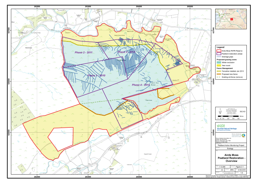
Figure 2. Overview of the peatland restoration conducted at Airds Moss
Click for a full description
The RSPB reserve at Airds Moss is delineated in red on an OS basemap. Proposed grazing zones where grazing is permitted year round (peach shading) and where grazers are excluded in winter (blue shading) are shown.
The reserve is subdivided according to phases of Peatland Action restoration work, delineated in purple:
- Phase 1 – 2010
- Phase 2 – 2011
- Phase 3 – 2012
- Phase 4 – 2014
Drainage grips, shown in blue, are throughout the reserve.
Fence lines are also shown:
- A fence installed in January 2013 is delineated in yellow.
- A fence to be removed is delineated with a green dashed line.
- A proposed new fence is delineated in orange.
Monitoring strategy
The sampling strategy was designed to monitor the change in vegetation after grip blocking and grazing regime changes had been applied to the blanket bog habitat. Samples were taken equally across three of the four separate phases of grip blocking work undertaken to the date of the survey. This enables some assessment of this year’s data as a ‘time since blocking’ dataset, as well as providing a baseline dataset to take forward. Each phase of grip blocking was allocated an Area code (A, B and C, respectively). The sample plots are outlined below:
- Area A - drains blocked in 2010;
- Area B - drains blocked in 2012; and
- Area C - drains blocked in 2014.
The sampling strategy excluded the area where self-seeded conifers are removed to avoid the complication of adding another factor into the analysis for part of the dataset (2010 only).
In each of Areas A, B and C a total of 15 2m x 2m quadrats were collected across a homogenous stand of the main vegetation type within the treated area. Quadrats were sampled randomly within the homogeneous vegetation stand. The abundances of all plant species were recorded as percent cover. A number of environmental and vegetation community measurements were also taken, including cover of bare peat, vegetation height and presence of dung (see Annex I for further details).
In addition, the length of the drain between two blocks was sampled at three separate locations within each Area, again selecting typical examples of the restoration approach. At these sample points a plan of the vegetation was sketched (included in field note only, not presented in this report) and the percent cover of plant species noted along with the environmental and vegetation community variables. The sample points were marked with a small wooden stake to enable relocation in the future.
The quadrat sample set (45 quadrats across Area A, B and C) allows for robust statistical analysis of vegetation community change over time, and also immediate analysis of ‘time since blocking’ (Figure 3). The samples taken between the ditch blocks (9 sample points across Areas A, B and C) can be assessed individually over time as changes in the area of different components of the vegetation community (i.e. re-mapping the area between the grips and comparing change in vegetation community data over time). The opportunity for statistical analysis by combining all sample points is limited as each sample area was defined by the distance between the grip blocks and not as a consistent quadrat size.
Fixed point photographs of each area were taken to supplement the quadrat samples.
Baseline survey results
Table 4 presents a summary of the plant species recorded on each of the three sample areas along with their abundance (DAFOR scale). Quadrat data are presented in Annex 2 and locations shown within Figure 3. The fixed point photographs are presented within Annex III and their locations shown on Figure 4. Each sample area is described below.
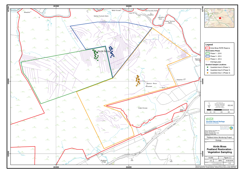
Figure 3. The locations of the vegetation survey quadrats at Airds Moss
Click for a full description
A section of the RSPB reserve at Airds Moss is delineated in red on an OS basemap.
The reserve is subdivided according to phases of restoration work:
- Phase 1 – 2010 delineated in green
- Phase 3 – 2012 delineated in blue
- Phase 4 – 2014 delineated in orange.
Drainage grips are shown in purple throughout most of the reserve.
The locations of three clusters of vegetation survey quadrats are shown as numbered squares:
- Area A, in Phase 1 in green
- Area B, in Phase 3 in blue
- Area C, in Phase 4 in orange.
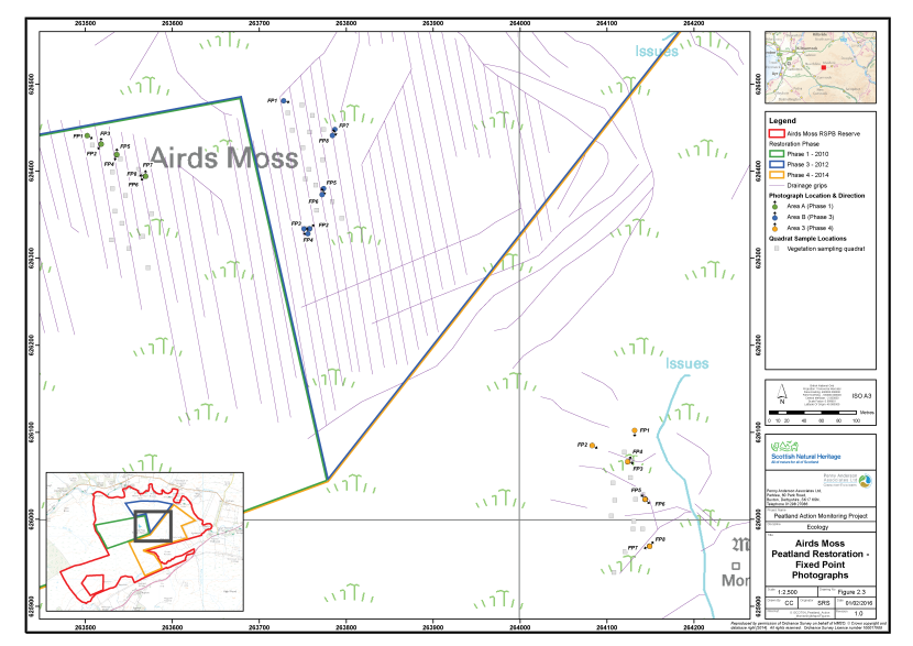
Figure 4. The locations of fixed point photography at Airds Moss
Click for a full description
A section of the RSPB reserve at Airds Moss on an OS basemap. An inset map indicates the area in the context of the reserve boundary.
The reserve is subdivided according to phases of restoration work:
- Phase 1 – 2010 delineated in green
- Phase 3 – 2012 delineated in blue
- Phase 4 – 2014 delineated in orange.
Drainage grips are shown in purple throughout most of the reserve.
The locations of three clusters of fixed point photography points are shown as filled circles with arrows indicating the direction the photographer faced.
- Area A, in Phase 1 in green
- Area B, in Phase 3 in blue
- Area C, in Phase 4 in orange.
Table 4. Abundance of plants recorded in the sample plots, Airds Moss, 2014
|
Common Name |
Scientific Name |
Area A |
Area B |
Area C |
|---|---|---|---|---|
|
Bilberry |
Vaccinium myrtillus |
R |
- |
R |
|
Bog asphodel |
Narthecium ossifragum |
R |
- |
- |
|
Broad buckler-fern |
Dryopteris dilatata |
R |
- |
- |
|
Common sedge |
Carex nigra |
- |
- |
R |
|
Cranberry |
Vaccinium oxycoccos |
- |
O |
- |
|
Cross-leaved heath |
Erica tetralix |
O-F |
O |
O |
|
Hare's-tail cottongrass |
Eriophorum vaginatum |
F-A |
O |
O-R |
|
Heath bedstraw |
Galium saxatile |
O |
R |
F |
|
Heath rush |
Juncus squarrosus |
- |
- |
R-O |
|
Heath wood-rush |
Luzula multiflora |
- |
- |
O |
|
Heather |
Calluna vulgaris |
R |
- |
- |
|
Purple moor-grass |
Molinia caerulea |
A |
D |
A-LD |
|
Sweet vernal-grass |
Anthoxanthum odoratum |
- |
- |
R |
|
Tormentil |
Potentilla erecta |
O-F |
R |
F |
|
Wavy hair-grass |
Deschampsia flexuosa |
O |
R |
O |
|
A bog moss |
Sphagnum capillifolium |
- |
F |
- |
|
A bog moss |
Sphagnum capillifolium subsp capillifolium |
F |
- |
- |
|
A bog moss |
Sphagnum capillifolium subsp rubellum |
R |
- |
O-R |
|
A bog moss |
Sphagnum fallax |
- |
R |
- |
|
A bog moss |
Sphagnum magellanicum |
- |
R |
- |
|
A moss |
Hylocomium splendens |
F |
R |
- |
|
A moss |
Hypnum jutlandicum |
- |
R |
- |
|
A moss |
Pleurozium schreberi |
F |
O |
- |
|
A moss |
Polytrichum commune |
- |
O |
O |
|
A moss |
Polytrichum strictum |
- |
F |
- |
Area A – Drains blocked in 2010
The sample area comprises bog on gently sloping north-facing ground which has been subject to significant artificial drainage (grips) in the past. In 2010 the grips were blocking in order to raise water levels and restore hydrology. The grip blocks are formed from peat and have been installed approximately every 5m. They are now well re-vegetated with frequent to abundant aquatic Sphagnum in most pools. There are some signs of water topping over the dams when the grips behind are at ‘bank-full’ capacity but generally this is relatively rare across the area, although no discernable flow at the time of survey. Water depth in the pools behind the grip blocks is typically 30 to 60cm.
In-channel vegetation comprises abundant purple moor-grass, frequent to occasional hare’s-tail cottongrass locally frequent Sphagnum fallax, occasional S. palustre and rare S. magellanicum (the latter two being important ombrotrophic peat forming species). Soft rush (Juncus effusus) has colonised some lower level pools behind grip blocks. There is little or no bare peat present and no signs of peat compaction as a result of the grip blocking works.
On the main bog expanse the vegetation also has abundant purple moor-grass with frequent hare’s-tail cottongrass (Eriophorum vaginatum). Cross-leaved heath (Erica tetralix) is constant throughout at about 10% cover, as are tormentil (Potentilla erecta) and heath bedstraw (Galium saxatile). Sphagnum species are frequent including hummocks of S. capillifolium, but a relatively small number of species recorded. There was little evidence of grazing animals on the area and purple moor-grass litter is accumulating beneath the sward.
The vegetation is considered to be most similar to M17 Trichophorum germanicum – Eriophorum vaginatum blanket mire (Rodwell 1991) with the abundance of purple moor-grass likely to reflect past agricultural management such as higher sheep stocking rates and regular burning (Averis et al. 2004). In addition, M2 Sphagnum cuspidatum/recurvum bog pools occur behind the majority of grip blocks and across the wider site.
A total of 15 quadrats were taken within this vegetation type, along with three samples behind the grip blocks to assess the revegetation of the drains over time. Eight fixed point photograph points were set up, including both the grip blocks and general sample areas.
Area B – Drains blocked in 2012
This sample area comprised a similar situation to Area A, however, the grip blocking was installed in 2012. Again, the blocks are made of peat with some areas having turves of vegetation removed to cap the dams. Where this has happened, there are some areas of bare peat still remaining on the site, indicating recovery from this type of disturbance is very slow on these sites. The dams are functioning well and holding water, with Sphagnum fallax typically colonising the pools that have developed behind them.
Across the wider bog the vegetation is again dominated by purple moor-grass with occasional to rare cross-leaved heath, hare’s-tail cottongrass, tormentil and cranberry. There are frequent hummocks of Polytrichum strictum and Sphagnum capillifolium ssp. capillifolium. There are no obvious signs of stock grazing, although signs of grouse are present. The vegetation is again most similar to M17 Trichophorum germanicum – Eriophorum vaginatum blanket mire (Rodwell 1991) with the abundance of purple moor-grass likely to reflect past agricultural management such as higher sheep stocking rates and regular burning (Averis et al. 2004).
A total of 15 quadrats were taken within this vegetation type along with three samples behind the grip blocks to assess the re-vegetation of the drains over time. Eight fixed point photograph points were set up, including both the grip blocks and general sample areas.
Area C – Drains blocked in 2014
On this area, although artificial drainage was present on the site, the intensity of grips was less and as such the area available for sampling was more limited. The site selected was on deep peat and had been drained (largely into a natural gully system) and then blocked with peat in 2014. The location and situation, however, was slightly different to Areas A and B with slightly shallower peats (up to 70cm) on a slightly steeper eastern-facing slope resulting in a slightly drier vegetation type with a more species typical of acid grassland. Purple moor-grass is still abundant to locally dominant, with occasional hare’s-tail cottongrass and cross-leaved heath but with the addition of heath rush (Juncus squarrosus), sheep’s fescue (Festuca ovina), wavy hair-grass (Deschampsia flexuosa) and sweet vernal-grass (Anthoxanthum odoratum) along with tormentil. Sphagnum capillifolium ssp. capillifolium is locally frequent, but few other Sphagnum were recorded here.
The peat damming operation has exposed some underlying mineral ground in some areas due to the thinner peat deposits in this area. The peat dams have also been installed in part into the natural drainage gully feature in this area, which may disrupt the natural drainage pattern of the site and lead to risk of erosion and peat dam wash-out or failure.
The vegetation is again most similar to degraded M17 Trichophorum germanicum – Eriophorum vaginatum blanket mire (Rodwell 1991). Again, the abundance of purple moor-grass and presence of heath rush likely to reflect past agricultural management such as higher sheep stocking rates and regular burning (Averis et al. 2004).
A total of 15 quadrats were taken within this vegetation type along with three samples behind the grip blocks to assess the re-vegetation of the drains over time. Eight fixed point photograph points were set up, including both the grip blocks and general sample areas.
Constraints on survey
No significant constraints on setting up the baseline monitoring were encountered. All areas were accessible to the survey team and the background data provided good information from which to select sample areas.
Selection of sample areas was straightforward on Areas A and B as there were extensively drained areas which enabled patches of homogeneous vegetation typical of the blanket bog habitat to be sampled around the drains that had been blocked. On Area C the drainage was less extensive and only one area was suitable for sampling, which was slightly less typical of the site as a whole, being a more sloping, drier area with less deep peat. This difference should be noted in any future analysis of vegetation change in response to grip blocking.
Access to the site is relatively straightforward and should follow the guidance of the NatureScot Site Manager.
Assessment of restoration approach
In general the restoration approach has been undertaken sensitively and the resulting peat dams are functioning well and holding back water within which aquatic Sphagnum species are colonising.
Area C is at some risk of the peat dams failing where they have been installed in the natural gully drainage feature which the artificial grips run into. Blocking areas such as this can disrupt natural drainage patterns and lead to water eroding around the peat blocks, causing further damage to the site, or washing out the peat dam within a fairly short time. This can be particularly problematic in period of high rainfall when the gullies receive a lot of water off the main mire expanse.
There is some indication of a slow recovery rate on bare peat exposed during dam construction on the area blocked in 2012 (Area B). The lack of exposed bare peat in the 2010 sample area (Area A) suggests, however, that over time a suitable vegetation cover will establish.
In terms of vegetation change expected on the site, raised water levels across the site should encourage expansion and colonisation of the key peat-forming bog-moss species including Sphagnum papillosum and S. magellanicum already present on the site (Lindsay 2010). The removal of stock in the winter is also likely to benefit the recovery and condition of typical bog species and keep any vigorous grasses in check. However, the abundance of purple moor-grass may be a more difficult problem under the current grazing regime, as sheep grazing at 0.07 LU/ha during the summer months may not be sufficient off-take to reduce this species dominance, or reductions may not be observable for some years (Marrs et al. 2004, Todd et al. 2000). Mixed sheep and cattle grazing can, however, have more beneficial results for purple moor-grass management although there can be some trampling impacts on other species (Critchley et al. 2008). Careful additional monitoring and review of the grazing regime will enable the stocking rate to be altered if required in future years, including the addition of cattle if considered appropriate.
It is recommended that a repeat survey in 2016 is a suitable timeframe for monitoring along with on-going assessment and maintenance of the integrity of the dams. The proposed hydrological monitoring, once in place, will provide valuable supplementary data for the restoration scheme, and increasing the number of dipwells proposed would be worthwhile if resources allow.
Arran - West Glensherraig and A'Chruach
Overview of the site
The Arran restoration site is located close to the centre of the island, approximately 3.5 miles west of the Brodick. The site comprises two separate restoration areas, lying to the north and south of the main road across the middle of the island, ‘The String’. The northern restoration area is located to the south-west of the summit of Cul nan Creagan (352m). The southern restoration area is located around the summit of Cnoc Dubh (425m) (Figure 5).
Both restoration areas are within the Arran Moors SSSI, designated for its assemblage of upland habitats, of assemblage of upland birds and breeding hen harrier (Circus cyaneus). The site is also designated as an SPA (Arran Moors) for the latter species. The upland habitat assemblage consists of wet and dry heath; blanket bog; subalpine flushes; and acid grassland. There are also waterbodies and mosaics of acid grassland with rush communities within some of the lowland areas. Small areas of broad-leaved woodland including areas of eared willow (Salix aurita) scrub are also present, typically associated with incised water courses and river valleys.
The Cnoc Dubh restoration area also lies partially within Gleann Dubh SSSI. This site is designated for its upland habitat assemblage and general breeding bird assemblage. The upland habitat assemblage is unusual on Arran for the abundance and quality of the base-enriched subalpine flushes and calcareous rocky slope plant communities. The upland assemblage also contains areas of blanket bog and dry heath.
The Cul nan Creagan restoration area comprises a south-west facing sloping area of deep peat dominated by purple moor-grass. Drains up to 1.25m deep and approximately 0.5m wide have been cut into the slope at approximately 10m intervals and these discharge water into the Gleann Easbuig burn below. Red deer (Cervus elaphus) stalking is the primary activity on the site and there is a deer fence along The String, to confine the herd to the northern side of the road.
The Cnoc Dubh restoration area comprises a north-east facing slope, with a series of large peat haggs facing in various directions. The haggs extend northwards and onto the south-facing slope of the neighbouring fell. Vegetation here is heather (Calluna vulgaris) dominated blanket bog, which appears to have been derived by burning, although this is not currently intensive and much of the heather is mature.
Existing monitoring on site
Information received from NatureScot does not indicate whether there is any ongoing hydrological or vegetation monitoring of the site.
Restoration measures undertaken
No restoration measures had been implemented at the time of the survey and therefore the dataset collected represents the pre-treatment baseline state of the sample plots. Detailed location maps or GIS data for the restoration measures weren’t available at the time of the survey, although these were supplied subsequently.
The Peatland Action grant application form proposes the following restoration measures for the site:
- 444 dams over 4000m of ditches together with 3 reinforced plastic dams;
- Re-shaping of 200 peat haggs; and
- Tree removal over 525ha.
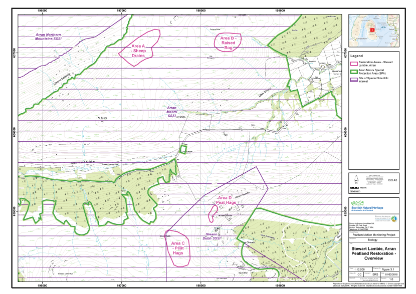
Figure 5. Overview of the peatland restoration areas and designated areas at West Glensherraig and A'Chruach, Arran
Click for a full description
The West Glensherraig and A'Chruach area of Arran is shown on an OS basemap.
There are four polygons, delineated in pink, which represent the areas of restoration:
- Area A – Sheep drains
- Area B – Raised bog
- Area C – Peat haggs
- Area D – Peat haggs
The Arran Moors Special Protection Area is delineated with a thick green line.
The Arran Moors SSSI is represented by horizontally hashed purple polygon.
Monitoring strategy
The strategy was designed to monitor the change in vegetation post treatment. A total of five samples were taken, each allocated an Area code (A, B, C, D and E respectively). As no detailed mapping was available at the time of the survey, the surveyors exercised a degree of interpretation as to the layout of the treatments and therefore where to position the sample plots.
Samples of the two main treatments (ditch blocking and re-profiling) were taken, together with two additional samples. The additional sample in the Cnoc Dubh area (Area D) was originally intended as a control area but, following receipt of detailed mapping, it appears that the area would be re-profiled. This sample will likely therefore be a second pre-treatment sample for the re-profiling treatment.
The additional sample in the Cul nan Creagan area (Area B) was taken to reflect the variation in hydrology and vegetation of the drained parts of the site. However, following receipt of more detailed mapping it appears that ditches in this area will not be blocked. Unfortunately, because the gradient and vegetation of this sample plot are different to the treated area (Area A) Area B would not be a suitable control site. However, it is recommended that drain blocking is implemented in Area B as it represents perhaps the most readily ‘restorable’ peatland on the northern part of the site. The sample plots are outlined below:
- Area A - Drain blocking I (Pre-treatment baseline);
- Area B - Drain blocking II (Possible pre-treatment baseline);
- Area C - Peat hagg re-profiling I (Pre-treatment baseline);
- Area D - Peat hagg re-profiling II summit (Pre-treatment baseline); and
- Area E - Relatively unmodified M17 bog (Reference).
In each of Areas A, B, C, D and E a total of 15 2m x 2m quadrats were collected across a homogenous stand of the main vegetation type within the treated area. Quadrats were sampled randomly within the homogeneous vegetation stand. The abundances of all plant species were recorded as percent cover. A number of environmental and vegetation community measurements were also taken, including cover of bare peat, vegetation height and presence of dung (see Annex I for further details).
The quadrat survey targeted several aspects of the restoration approaches, which varied by Area. In Areas A and B the vegetation between the drains was sampled. These data will provide a baseline against which success of the blocking treatment can be assessed in the future. In Areas C and D bare peat on the eroding faces of the haggs was targeted to provide a baseline against which success of the re-profiling treatment can be assessed in the future. To provide a reference site (Area E), the site was searched for a relatively unmodified stand of blanket bog vegetation and this was sampled. No reference site was available for the heather-dominated bog that characterises Areas C and D as all areas that were representative of this feature were severely hagged. The quadrat sample set (75 quadrats across Areas A, B, C, D and E) allows for robust statistical analysis of change in the vegetation communities change over time.
Fixed point photographs of each area were taken to supplement the 2m x 2m quadrat samples.
Baseline survey results
Table 5 presents a summary of the plant species recorded in each of the five sample areas along with their abundance (DAFOR scale). Quadrat data are presented in Annex II and their locations area shown on Figure 6. The fixed point photographs are presented within Annex III and their locations shown on Figure 7. Each sample area is described below.
Table 5. Abundance of plants recorded in the sample plots, Arran, 2015
|
Common Name |
Scientific Name |
Area A |
Area B |
Area C |
Area D |
Area E |
|---|---|---|---|---|---|---|
|
Bare peat |
- |
- |
- |
D |
D |
- |
|
Heather |
Calluna vulgaris |
F |
O |
R |
R |
F |
|
Common Cottongrass |
Eriophorum angustifolium |
F |
F |
F |
O |
O |
|
Cross-leaved Heath |
Erica tetralix |
F |
F |
- |
- |
F |
|
Hare's-tail Cottongrass |
Eriophorum vaginatum |
A |
F |
- |
- |
D |
|
Deergrass |
Trichophorum germanicum |
R |
R |
- |
- |
F |
|
Bog Asphodel |
Narthecium ossifragum |
- |
O |
- |
- |
A |
|
Heath Milkwort |
Polygala serpyllifolia |
O |
R |
- |
- |
- |
|
Tormentil |
Potentilla erecta |
O |
O |
- |
- |
- |
|
Common bent |
Agrostis capillaris |
- |
- |
- |
O |
- |
|
Round-leaved Sundew |
Drosera rotundifolia |
- |
O |
- |
- |
- |
|
Crowberry |
Empetrum nigrum |
- |
- |
- |
- |
R |
|
Purple Moor-grass |
Molinia caerulea |
D |
- |
- |
- |
- |
|
A moss |
Racomitrium lanuginosum |
O |
O |
O |
- |
- |
|
A moss |
Campylopus flexuosus |
O |
R |
- |
- |
- |
|
A moss |
Campylopus introflexus |
R |
R |
- |
- |
- |
|
A moss |
Dicranella heteromalla |
- |
- |
O |
O |
- |
|
A moss |
Hypnum jutlandicum |
O |
O |
- |
- |
- |
|
A moss |
Leucobryum glaucum |
O |
O |
- |
- |
- |
|
A moss |
Polytrichum commune |
R |
- |
- |
- |
- |
|
A bog moss |
Sphagnum capillifolium subsp rubellum |
A |
A |
- |
- |
A-D |
|
A bog moss |
Sphagnum magellanicum |
R |
F |
- |
- |
R |
|
A bog moss |
Sphagnum papillosum |
F |
O |
- |
- |
O |
|
A bog moss |
Sphagnum tenellum |
F |
O |
- |
- |
T |
|
A bog moss |
Sphagnum cuspidatum |
- |
- |
- |
- |
R |
|
A bog moss |
Sphagnum fallax |
- |
- |
- |
- |
R |
|
A bog moss |
Sphagnum subnitens |
- |
R |
- |
- |
- |
|
A liverwort |
Mylia taylorii |
- |
- |
- |
- |
R |
|
A lichen |
Cladonia sp. (crustose) |
- |
- |
R |
- |
- |

Figure 6. The locations of the vegetation survey quadrats at West Glensherraig and A'Chruach, Arran
Click for a full description
The West Glensherraig and A'Chruach area of Arran is shown on an OS basemap.
There are four polygons, delineated in pink, which represent the areas of restoration:
- Area A – Sheep drains
- Area B – Raised bog
- Area C – Peat haggs
- Area D – Peat haggs
The locations of five clusters of vegetation survey quadrats are shown as filled squares:
- Area A, in green
- Area B, in blue
- Area C, in orange
- Area D, in purple
- Area E, in yellow
There is an inset map linked to each cluster, which is a zoomed in view of the vegetation survey quadrat locations, and shows the quadrat numbers.
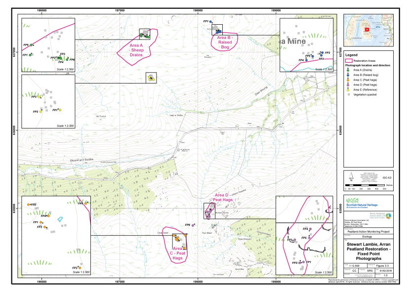
Figure 7. The locations of fixed point photography at West Glensherraig and A'Chruach, Arran
Click for a full description
The West Glensherraig and A'Chruach area of Arran is shown on an OS basemap.
There are four polygons, delineated in pink, which represent the areas of restoration:
- Area A – Sheep drains
- Area B – Raised Bog
- Area C – Peat haggs
- Area D – Peat haggs
The locations of five clusters of fixed point photography points are shown as filled circles with an arrow indicating the direction the photographer faced:
- Area A, in green
- Area B, in blue
- Area C, in orange
- Area D, in purple
- Area E, in yellow.
The location of the vegetation survey quadrats are show as filled grey squares.
Area A - Drain blocking I
This sample plot comprised a west-facing slope with seven drains up to 1.25m deep and approximately 0.5m wide. The bases of some of the drains had been eroded to the underlying mineral material, particularly, where the slope was steeper and the peat shallower at their top edges. There was little sign of re-colonisation of the drains, probably due to their depth and the scouring effect of the incline.
Vegetation between the drains was dominated by purple moor-grass but also included common cottongrass (Eriophorum angustifolium), and constant Sphagnum capillifolium subsp. rubellum, which reached high abundance values in places. Other associated species included cross-leaved heath, heather, tormentil, Sphagnum tenellum, S. papillosum and S. magellanicum.
In common with the rest of the site, to the north of The String, signs of heavy deer grazing were abundant. These included abundant dung and evidence of trampling of Sphagnum cushions and on bare peat.
Area B - Drain blocking II
This sample plot comprised a gentle south-east facing slope in Coire na Mine, west of Cul nan Creagan. The area is drained by grips at 10m intervals, which feed into Alltan Bhrighide. The drains were generally around 0.25m deep at the northern edge of the slope and increased to 1.20m deep above the burn.
The vegetation between the ditches comprised purple moor-grass-dominated blanket bog, probably having been derived from M17 vegetation by drainage, heavy grazing and burning. Associated vascular plants typical of M17 bog included hare’s-tail cottongrass, cross-leaved heath, heather, common cottongrass, bog asphodel (Narthecium ossifragum) and deergrass (Trichophorum germanicum). Bryophytes included abundant Sphagnum capillifolium subsp. rubellum together with S. magellanicum and S. tenellum.
Some of the drains were partially in-filled with Sphagnum species and purple moor-grass litter and were generally much less severely eroded than those in Area A. The vegetation here showed a stronger affinity to M17 bog than in Area A, which suggests the effect of drainage has been less damaging here.
In common with the rest of the site, to the north of The String, signs of heavy deer grazing were abundant. These included abundant dung and evidence of trampling of Sphagnum cushions and on bare peat.
Area C - Hagg re-profiling I
This sample plot comprised a large area of hagged peat located around the summit of Cnoc Dubh, extending northwards onto the neighbouring fell (see Area D). The peat in this area was estimated to be up approximately 5m deep, as evidenced by haggs of up to 3m standing adjacent to mineral ground on plinths of deep peat. The north faces of the haggs were generally in poor and eroding condition, while the south faces of some were intact or regenerating naturally.
The site appeared to be lightly managed, with approximately 50% of the heather in either mature or late mature states, although there was evidence of a large recent burn to the north of the sample plot. It is likely that the site was burnt more intensively in the past, which has caused the current heather dominance and severe hagging.
The vegetation on the hagg tops and remaining deep peat between the haggs comprised heather dominated blanket bog, with bell heather (Erica cinerea), common cottongrass, hare’s-tail cottongrass, heath rush and the mosses Hypnum jutlandicum, Racomitrium lanuginosum and Sphagnum capillifolium subsp. rubellum. The bare eroding faces of the haggs supported sparse common cottongrass, heather, Dicranella heteromalla and Racomitrium lanuginosum.
Between the haggs were some very wet runnels with abundant S. fallax and areas of redeposited peat with abundant common cottongrass.
Area D - Hagg re-profiling II
This sample plot is situated approximately 400m north-east of Area C and comprised a range of peat haggs up to approximately 2.5m high, facing in various directions. Most haggs were subtended by a patch of mineral material, which suggested gradient of the slope and the exposure to the weather have increased the rate of erosion in this location. Fire was considered likely to have been a major factor in the development of the haggs. The peat depth and severity of hagging lessened towards the summit of the fell.
Vegetation on the hagg tops and, to a certain extent, on the adjacent mineral ground was dominated by heather with bell heather together with common cottongrass, Sphagnum capillifolium subsp. rubellum and Hypnum jutlandicum. As in Area C, a large proportion of the heather was in the mature/late mature stages of growth. The bare eroding faces of the haggs supported little vegetation other than sparse heather, common cottongrass, velvet bent (Agrostis canina) and Dicranella heteromalla.
Area E - Relatively unmodified M17 bog (Reference)
This sample plot lies to the south of Area A above the head of Leac a’ Ghille and represented the best example of M17 bog in proximity to Areas A and B.
Although there was a general lack of Sphagnum papillosum and the cover of hare’s-tail cotton-grass was quite high, the vegetation showed strong affinities to M17 bog. In addition to hare’s-tail cottongrass, bog asphodel was abundant and deergrass, cross-leaved heath and heather were all frequent. The bryophyte component of the vegetation comprised very abundant S. capillifolium subsp. Rubellum, together with occasional S. papillosum and S. cuspidatum, S. tenellum and S. magellanicum. The western liverwort Mylia taylorii was also present in loose mats beneath the vascular plants.
In common with the rest of the site, to the north of The String, signs of heavy deer grazing were abundant. These included abundant dung and evidence of trampling of Sphagnum cushions, and on bare peat, and also wallowing in soft areas of peat.
Constraints on survey
The only mapping of the area available at the time of the survey was hand drawn onto the 1:25,000 scale OS map of the area. This lack of precise and accurate mapping necessitated a degree of surveyor interpretation in the field and resulted in an area being surveyed that was not included in the restoration plan. Other than this, there were no significant constraints noted for the survey.
Access to the Cul nan Creagan area was via a relatively well marked path from the summit of The String, although the path had to be attained by carefully climbing through the deer fence. Access to the Cnoc Dubh area was less well marked and involved ascending, to the east of a large forestry plantation, to the saddle just to the north of Cnoc Dubh. The site was accessed from the saddle. Both sites were accessed from a lay-by just after the summit of The String, on the southern side of the road.
Assessment of restoration approach
Future monitoring datasets will enable post-treatment change in the vegetation between the blocked drains (Areas A and B) and on the re-profiled peat haggs (Areas C and D) to be assessed in detail. The 2015 dataset will form a valuable pre-treatment baseline against which future post-treatment datasets for this area can be compared. It will also be possible to compare future samples from Areas A and B to the reference site (Area E), to provide an assessment of whether vegetation in the treated areas undergoes a shift toward unmodified bog typical of the local area. No reference site was available for Areas C and D, however, the success criterion for these areas is simply whether the bare peat has been re-vegetated and is thus much easier to measure than for Areas A and B where subtle shifts in the vegetation will need to be measured and compared to a target community.
The outline specification for the restoration work suggests that the main dam construction material would be peat. This has been used with at least short-term success (and projected long-term success) on several other sites surveyed as part of this project; for example Drumrunie and Flanders Moss. This method has also been successfully employed on many other restoration sites in the UK.
Peat dams are not appropriate where the peat has completely washed out from the bases of drainage channels and gullies, as has occurred in some of the drains in Area A. The risk of wash out might also be increased in Area A, because of the relatively steep gradient of the site, and it may be prudent to reinforce dams with plastic in places. Care must also be taken to make sure that the dams are set at the correct spacing to allow water retention to above the base of the upstream dam to prevent exposure of the grip walls. Correctly levelling the dams will prevent degradation of the walls of the drains by drying and will also lessen the height that any water over topping the dams has to fall, reducing the potential for scouring below each dam.
The latest project information received from NatureScot suggests the gripped area of moor around and including Area B will not be restored under this Peatland Action grant. However, the survey strongly suggested that this area was very suitable for restoration. The vegetation here was actually in better condition than in Area A and the topography flatter, suggesting that reversion to good biological condition could happen sooner in Area B. It would be very worthwhile to expand the scope of the project to include the gripped moor around Area B or consider a follow-up project to treat this area in the future.
The re-profiling treatment scheduled for Areas C and D is considered likely to be successful. This intervention has been used with at least short-term success (and projected long-term success) on several other sites surveyed as part of ‘Monitoring the Success of Peatland Action’ (e.g. Edinglassie and Glen Ey) and on restoration sites around the UK.
It is considered likely there will be a continued heather dominance in Areas C and D post-treatment. This is not considered a major shortcoming of the technique, as the aim of the treatment is to prevent further weathering of the exposed bare peat, and therefore loss of carbon from the system, rather than to restore peat-forming vegetation per se. It is recommended that re-vegetation of the haggs is addressed through patching with turf in the first instance, supplemented by seeding and stabilisation with heather brash and geojute where there is a shortfall in turf.
A re-survey of the site in 2018 would be a suitable timeframe for monitoring, along with more regular on-going liaison with the contractors.
Dundreggan
Overview of the site
Dudreggan lies between Invermoriston and Bun Loyne, to the west of Loch Ness. The site is not subject to any statutory designations, however, it is part of the catchment of the River Moriston. The River is designated as an SAC for its populations of Atlantic salmon (Salmo salar) and freshwater pearl mussel. The extensive Glen Affric to Strathconon SPA, designated for golden eagle, lies approximately 15km to the north.
The Dundreggan restoration site (Figure 8) comprises a 200ha area planted with Sitka spruce (Picea sitchensis), Lodgepole pine (Pinus contorta) and Scot’s pine (Pinus sylvestris) as commercial conifer forest in the mid-1980s. The site has a variable topography consisting of knolls and hollows; a peat depth survey in 2013 showed that a substantial area of the overall plantation was on peat greater than 0.5m deep. Areas of intact blanket bog vegetation are present on the wettest peats between the plantation blocks.
Existing monitoring on site
A hydrological monitoring regime has been put in place by NatureScot. Monitoring equipment comprises piezometers and a rain gauge installed in March 2015, and aims to measure the impact of tree removal and ditch blocking on the water table of part of the site.
Restoration measures undertaken
Peatland restoration at Dundreggan was undertaken during winter 2014/2015 and comprised a single treatment. The treatment involved felling approximately 18ha of conifer plantation using excavators equipped with mulching heads, with larger trees felled by chainsaw. The felled tree material was subsequently packed into furrow lines by the excavators. In addition, a total of 62 peat dams were installed on flowing forest drains, mainly in the central area of the site. Further restoration work is planned for the site; Trees for Life intend to undertake Sphagnum seeding and control of non-native regeneration following the mulching treatment.
In addition to the direct restoration work, a deer fence has been erected around the perimeter of the 200ha site. A Restoration Report has been produced by Trees for Life, detailing the work undertaken (Gilbert 2015)
Monitoring of the restoration measures took place on 11th August 2015 by Dr Sarah Ross (Associate Director, MCIEEM, CEnv) and Alistair Blackshaw (Senior Ecologist, MCIEEM).
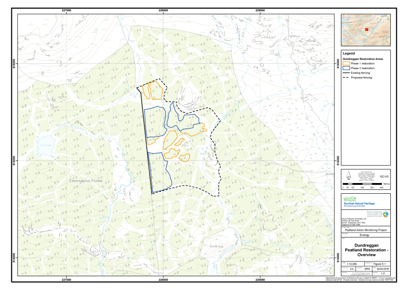
Figure 8. Overview of the peatland restoration conducted at Dundreggan
Click for a full description
The Dundreggan area is delineated in red on an OS basemap.
Two phases of Peatland Action restoration work are delineated along with an existing and proposed fence line.
- Restoration phase 1 is delineated in yellow
- Restoration phase 2 is delineated in blue
- The existing fence is represented by a black line, and the proposed fence with a dashed black line.
Monitoring strategy
The strategy was designed to monitor the change in vegetation post treatment. A total of four samples were taken, each allocated an Area code (A, B, C and D respectively). Two of the Areas had been treated, a third area comprised an untreated control and the final area comprised a reference site. The sample plots are outlined below:
- Area A - Untreated standing plantation (Control);
- Area B - Unplanted and relatively unmodified blanket bog (Reference);
- Area C - Treated former plantation on the north-facing slope of a knoll (Post-treatment sample); and
- Area D - Treated former plantation on a lower-lying wetter area (Post-treatment sample).
In each of Areas A, B, C and D a total of 20 2m x 2m quadrats were collected across a homogenous stand of the main vegetation type within the treated area. Quadrats were sampled randomly within the homogeneous vegetation stand. The abundances of all plant species were recorded as percent cover. A number of environmental and vegetation community measurements were also taken, including cover of bare peat, vegetation height and presence of dung (see Annex I for further details).
The quadrat survey targeted specific aspects of the vegetation in the different areas. In the control, Area A, the ground flora of the standing plantation was sampled as it is this aspect of the vegetation which reflects the affinities to the original bog vegetation, rather than the tree canopy. In Area B, sampling took place within an area of blanket bog vegetation that was considered representative of relatively unmodified bog on the site. In Areas C and D, which had been subject to treatment, sampling was undertaken within an area that was considered representative of the treatment in that particular location.
Sampling was undertaken approximately three months after the management treatment had been completed, therefore providing a good baseline for future monitoring of change in the vegetation of the Areas C and D. The addition of a control site (Area A), if it remains untreated, will enable assessment of the treated areas against the option of not treating the plantation. The reference site will enable an assessment of how similar the vegetation communities of the treated areas are to relatively unmodified bog in future years. The quadrat sample set (80 quadrats across Area A, B, C and D) therefore allows for robust statistical analysis of change in the vegetation communities change over time.
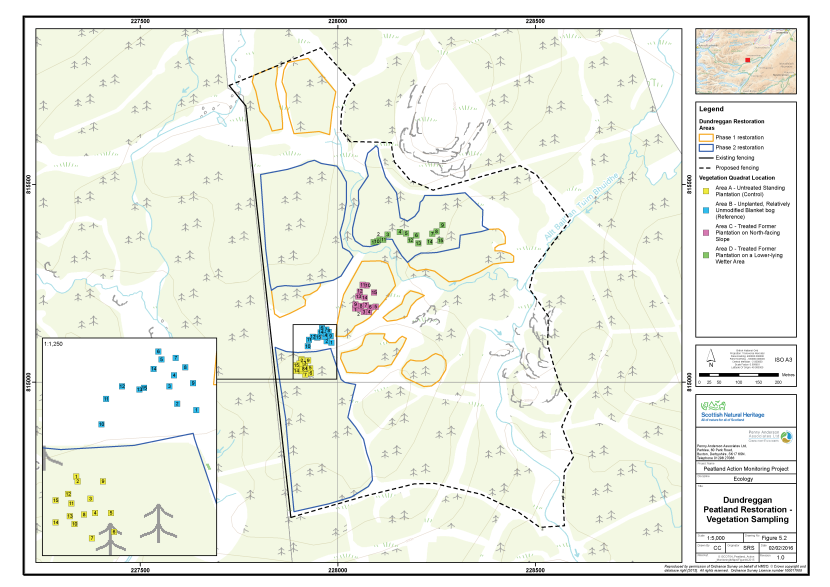
Figure 9. The locations of the vegetation survey quadrats at Dundreggan
Click for a full description
The Dundreggan area is shown on an OS basemap.
There are eight polygons, delineated in yellow, which represent the areas of restoration in Phase 1. Three polygons, delineated in blue, represent the areas of restoration in Phase 2.
The existing fence is represented by a black line, and the proposed fence with a dashed black line.
The locations of four clusters of vegetation survey quadrats are shown as filled, numbered squares:
- Area A, in yellow, untreated standing plantation (control)
- Area B, in blue, unplanted, relatively unmodified blanket bog (reference)
- Area C, in pink, treated former plantation on North-facing slope
- Area D, in green, treated former plantation in a low-lying, wetter area.
There is an inset map, which is a zoomed in view of the vegetation survey quadrat locations in sample areas A and B.
Fixed point photographs of each area were taken to supplement the 2m x 2m quadrat samples.
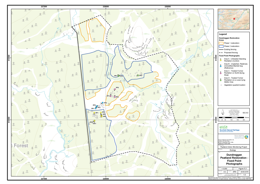
Figure 10. The locations of fixed point photography at Dundreggan
Click for a full description
The Dundreggan area is shown on an OS basemap.
There are eight polygons, delineated in yellow, which represent the areas of restoration in Phase 1. Three polygons, delineated in blue, represent the areas of restoration in Phase 2. The existing fence is represented by a black line, and the proposed fence with a dashed black line.
The locations of four clusters of fixed point photography locations are shown as filled circles with an arrow indicating the direction the photographer faced:
- Area A, in yellow, untreated standing plantation (control)
- Area B, in blue, unplanted, relatively unmodified blanket bog (reference)
- Area C, in pink, treated former plantation on North-facing slope
- Area D, in green, treated former plantation in a low-lying, wetter area.
The location of the vegetation survey quadrats are show as filled grey squares.
Baseline survey results
Table 6 presents a summary of the plant species recorded in each of the four sample areas along with their abundance (DAFOR scale). Quadrat data are presented in Annex II and their locations area shown on Figure 9. The fixed point photographs are presented within Annex III and their locations shown on Figure 10. Each sample area is described below.
Table 6. Abundance of plants recorded in the sample plots, Dundreggan, 2015
|
Common Name |
Scientific Name |
Area A |
Area B |
Area C |
Area D |
|---|---|---|---|---|---|
|
Pine needles (litter) |
- |
A |
- |
- |
- |
|
Bog asphodel |
Narthecium ossifragum |
- |
F |
- |
R |
|
Bog myrtle |
Myrica gale |
- |
F |
- |
- |
|
Broad buckler-fern |
Dryopteris dilatata |
- |
- |
- |
R |
|
Bulbous rush |
Juncus bulbosus |
- |
- |
R |
- |
|
Cross-leaved heath |
Erica tetralix |
R |
A |
- |
- |
|
Deergrass |
Trichophorum germanicum |
- |
A |
- |
- |
|
Great sundew |
Drosera anglica |
- |
F |
- |
- |
|
Hare's-tail cottongrass |
Eriophorum vaginatum |
- |
F |
- |
LA |
|
Heath milkwort |
Polygala serpyllifolia |
A |
- |
- |
- |
|
Heather |
Calluna vulgaris |
- |
A |
- |
- |
|
Pine (seedling) |
Pinus sp. (seedling) |
- |
- |
O |
O |
|
Purple moor-grass |
Molinia caerulea |
R |
R |
O |
A |
|
Round-leaved sundew |
Drosera rotundifolia |
- |
F |
- |
- |
|
Star sedge |
Carex echinata |
R |
- |
- |
- |
|
A moss |
Dicranum scoparium |
R |
- |
- |
- |
|
A moss |
Hylocomium splendens |
A |
- |
- |
F |
|
A moss |
Kindbergia praelonga |
R |
- |
- |
- |
|
A moss |
Leucobryum glaucum |
R |
- |
- |
- |
|
A moss |
Mnium hornum |
R |
- |
- |
- |
|
A moss |
Plagiothecium undulatum |
F |
- |
- |
- |
|
A moss |
Polytrichum commune |
O |
- |
- |
- |
|
A moss |
Ptilium crista-castrensis |
R |
- |
- |
- |
|
A moss |
Racomitrium lanuginosum |
- |
O |
- |
- |
|
A moss |
Rhytidiadelphus loreus |
A |
- |
- |
- |
|
A liverwort |
Lophocolea bidentata |
O |
- |
- |
- |
|
A liverwort |
Pleurozia purpurea |
- |
O |
- |
- |
|
A bog moss |
Sphagnum capillifolium subsp rubellum |
F |
A |
LO |
O |
|
A bog moss |
Sphagnum compactum |
- |
R |
- |
- |
|
A bog moss |
Sphagnum cuspidatum |
- |
F |
LF |
- |
|
A bog moss |
Sphagnum denticulatum |
- |
O |
- |
- |
|
A bog moss |
Sphagnum fallax |
- |
- |
LF |
- |
|
A bog moss |
Sphagnum papillosum |
- |
A |
- |
R |
|
A bog moss |
Sphagnum tenellum |
- |
A |
- |
- |
|
A lichen |
Cladonia portentosa |
R |
O |
- |
- |
Area A - Control
This sample plot comprised standing plantation at the northern edge of Area 3 (see Restoration Report). The dominant tree species were Norway spruce (Picea abies) and Lodgepole pine. The plantation was apparently unthinned, with the trees at 3m intervals. The former bog surface comprised a series of plough ridges, into which the timber crop had been planted, with furrows between. Only the tops of the plough ridges were sampled, as these were the most abundant topographical feature, in terms of surface area. The adjacent furrows were wetter, although none were considered to be flowing, and supported significantly different vegetation, usually with abundant Sphagnum species. The tops of the ridges supported a carpet of pine needles together with a range of pleurocarpous mosses typical of acidic upland habitats. In addition the bog moss Sphagnum capillifolium subsp. rubellum was frequent. Deer dung was noted in the plantation.
Area A was considered likely to be representative of the pre-treatment condition of the two treated areas of plantation (Areas C and D) and was thus chosen as a control site. If the area is felled in 2016 as planned, then it will no longer be a suitable control site. Nevertheless, the 2015 sample would still be valuable, as a pre-treatment baseline, which could be compared to future post-treatment monitoring data to assess change in the vegetation over time.
Area B - Reference
This sample plot comprised M17 blanket bog lying in a shallow hollow between Area A and the standing plantation to the north. Peat depth was more than 1m on average and there was occasional evidence of deer grazing. The blanket bog vegetation comprised deergrass, cross-leaved heath, bog asphodel, hare’s-tail cottongrass and Sphagnum papillosum. The great sundew was frequent in wetter hollows.
A hagged area of drier blanket bog to the north of the sample area suggested that there may have been disturbance here during the original planting works, which could have been exacerbated further by deer grazing. The sample area had been tracked over during the recent felling work, causing flattening of the vegetation, but no visible damage to the underlying peat.
Area B was considered to be the least modified area of blanket bog vegetation within the site. It was therefore chosen as a reference against which the vegetation of the treated areas could be compared in future monitoring.
Area C - Treated former plantation I
This sample plot comprised a plantation block which had been felled and mulched during winter 2014/2015. The surface of the peat on the plough ridges was covered with a layer of wood fragments and brash up to 10cm thick. The furrows had been packed with brash and larger tree fragments to a greater depth.
Vegetation mainly comprised sparse purple moor-grass, which was rooted in the peat beneath and had penetrated through the mulch layer. A wet area near the centre of the plot, where the mulch layer was thinner than average, supported frequent Sphagnum fallax and Sphagnum cuspidatum, however, this was considered to represent persistence of a former population of bog moss, rather than colonisation post treatment. There was little evidence of colonisation by typical blanket bog species at the time of the survey.
Area D - Treated former plantation II
This sample plot comprised a former plantation that had been treated following the method described in Para 5.3 during winter 2014/2015. The area was similar to Area C, although it was less sloping and slightly wetter in places. There were more frequent boulders amongst the wood fragments. The layer of fragments itself was a little shallower here than in Area C. The larger tree fragments and more abundant whole trunks within the furrows suggest this may have been a thinned plantation with larger trees.
Vegetation here was similar to Area C, with purple moor-grass forming the bulk of the vegetation cover within the more heavily mulched areas. Within wetter areas, where the covering of wood fragments was generally thinner, patches of typical blanket bog species including hare’s-tail cottongrass, bog asphodel, Sphagnum capillifolium subsp. rubellum and Sphagnum papillosum were present and showing some signs of regeneration and spread.
Constraints on survey
There were no significant constraints noted for the survey. Please note that a vehicle with good ground clearance and robust tyres is required for access to the parking at the eastern edge of the main afforested area. From the parking it is a further 20 minutes walk to Area D, with Area A a further 10 minute walk across very wet ground.
Assessment of restoration approach
The main treatment of ‘mulching’ the conifers at Dundreggan has created a mulch layer which is 5 - 8cm deep on average and is composed of quite large shards of timber and brash. No evidence, such as pooling of water in the furrows, was found during the survey to suggest that packing the furrows with wood fragments and brash had been as effective in raising the water table within the peat.
Although there are gaps in the mulch layer, especially in Area D, into which typical blanket bog vegetation could potentially colonise, it was considered that colonisation of the majority of the area could only take place once the mulch has rotted down. It is likely to be a significant amount of time before the mulch breaks down. In the meantime, the mulch layer, which will be richer in nutrients than the underlying peat, will be vulnerable to colonisation by vegetation that could out-compete blanket bog species growing in any gaps in the mulch.
There is a risk that early colonists of the mulch will be ruderal species such as brambles (Rubus fruticosus agg.) and rosebay willowherb (Chamerion angustifolium) together with grasses such as purple moor-grass and sweet vernal grass. There is the further possibility that such vegetation would be a precursor to birch (Betula spp.) woodland incorporating natural regeneration of conifers. Although tree regeneration may be browsed by deer under normal circumstances the deer fence and rough nature of the mulched areas may reduce this effect.
In summary, the outcome of the mulching treatment is considered uncertain because of the thickness of the mulch layer. There is also the possibility that the mulch will fundamentally alter the hydrology and nutrient regime of the growing surface of the underlying peat, providing a relatively freely-draining and nutrient-enriched environment. This is in contrast to blanket peat, which is characterised by stagnant and highly oligotrophic conditions. The risk of the treatment resulting in vegetation other than blanket bog is considered to be significant and the treated plots should therefore be monitored closely. It is likely that some aftercare in the form of volunteer tree removal may be required before the mulch rots down.
A re-survey of the site in 2017 would be a suitable timeframe for monitoring, along with more regular informal monitoring the condition of the treatment plots, with follow-up management as appropriate in the interim.
Dunruchan Farm
Overview of the site
The Dunruchan Farm restoration site is situated approximately 5.5km north-west of Braco, Perth and Kinross (Figure 11). The site occupies a plateau that forms the summit of Meall a’ Choire Odhair; Dunruchan Hill lies to the north. The site is not subject to any statutory designations. The primary land use on the restoration site is sheep rearing, although the northern and eastern sides of the hill are burnt grouse moor.
The restoration site comprises approximately 55ha of blanket bog that has undergone significant artificial drainage and long-term heavy grazing. Aerial photography also suggests that blanket peatland once extended over a wider area, but has now been replaced by purple moor-grass grassland and rushes. There is evidence of peat cutting at the northern edge of the restoration site, which may partly account for the loss of peat on from the hill.
The majority of the restoration site comprises blanket bog dominated by hare’s-tail cottongrass, with heather, cross-leaved heath, deergrass and bog asphodel. Sphagnum species include S. magellanicum, S. papillosum and S. capillifolium subsp. rubellum and S. capillifolium subsp. capillifolium. A gripped area in the southern part of the restoration site is supports abundant purple moor-grass, wavy hair-grass and Polytrichum commune, with comparatively little Sphagnum. The hillside to the west of the site is dominated by purple moor-grass.
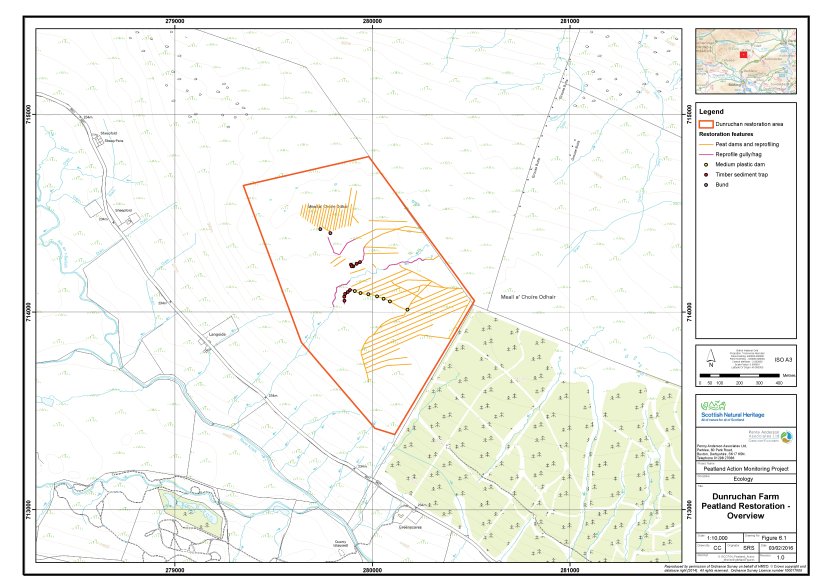
Figure 11. Overview of the peatland restoration conducted at Dunruchan Farm
Click for a full description
The area of peatland restoration at Dunruchan Farm is delineated in red on an OS basemap.
Restoration features comprise:
- Peat dams and reprofiling, represented by orange lines;
- Reprofiling of gullies and haggs, represented by purple lines;
- Medium plastic dams, represented by filled yellow circles;
- Timber sediment traps, represented by red filled circles;
- Bunds, represented by filled purple circles.
Existing monitoring on site
Information received from NatureScot does not indicate whether there is any ongoing hydrological or vegetation monitoring of the site.
Restoration measures undertaken
The main aim of the restoration project is to restore the hydrological integrity of the blanket peat and to slow the wash out of organic carbon from the peatland system. No restoration measures had been implemented at the time of the survey and therefore the dataset collected represents a pre-treatment baseline. The restoration measures proposed are:
- Construct 800 dams (mostly peat, with approx. seven plastic) along 12km of grips;
- Re-profile eroding edges of grips to facilitate natural re-vegetation;
- Construct 10 timber sediment traps; and
- Construct two 20m trench bunds.
Monitoring of the restoration measures took place on 14th October 2015 by Dr Sarah Ross (Associate Director, MCIEEM, CEnv) and Katherine Longden (Senior Ecologist, MCIEEM).
Monitoring strategy
The strategy was designed to monitor change in vegetation post treatment and focused on the gripped areas of the site, targeting two distinct vegetation types. A total of three samples were taken, each allocated an Area code (A, B, and C respectively). Two of the Areas had been treated, a third area comprised an untreated reference area. The sample plots are outlined below:
- Area A - Drain blocking I (Pre-treatment baseline);
- Area B - Undrained and relatively unmodified blanket bog (Reference); and
- Area C - Drain blocking II (Pre-treatment baseline)
In each of Areas A, B and C a total of 15 2m x 2m quadrats were collected across a homogenous stand of the main vegetation type within the treated area. Quadrats were sampled randomly within the homogeneous vegetation stand. The abundances of all plant species were recorded as percent cover. A number of environmental and vegetation community measurements were also taken, including cover of bare peat, vegetation height and presence of dung (see Annex I for further details).
In Areas A and C the quadrat survey targeted the vegetation between the grips, to provide an appropriate dataset to demonstrate a change over time in response to any re-wetting that may occur as a result of the grip blocking treatment. In Area B, sampling took place within an area of blanket bog vegetation that was considered representative of relatively unmodified bog on the site. This dataset will provide a reference point for good quality blanket bog against which the vegetation of the treated areas can be measured in the future.
Fixed point photographs of each area were taken to supplement the 2m x 2m quadrat samples.
Baseline survey results
Table 7 presents a summary of the plant species recorded in each of the four sample areas along with their abundance (DAFOR scale). Quadrat data are presented in Annex II and their locations area shown on Figure 12. The fixed point photographs are presented within Annex III and their locations shown on Figure 13. Each sample area is described below.
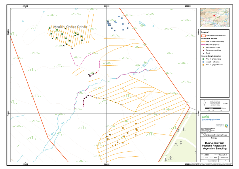
Figure 12. The vegetation survey quadrat locations at Dunruchan Farm
Click for a full description
The area of peatland restoration at Dunruchan Farm is delineated in red on an OS basemap.
Restoration features comprise:
- Peat dams and reprofiling, represented by orange lines;
- Reprofiling of gullys and haggs, represented by purple lines;
- Medium plastic dams, represented by filled yellow circles;
- Timber sediment traps, represented by red filled circles;
- Bunds, represented by filled purple circles.
The locations of three clusters of vegetation survey quadrats are shown as filled, numbered squares:
- Area A, in green, gripped bog
- Area B, in blue, reference
- Area C, in orange, gripped bog dominated by Molinia caerulea
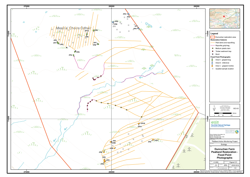
Figure 13. The locations of fixed point photography at Dunruchan Farm
Click for a full description
The Dunruchan Farm area is shown on an OS basemap.
Restoration features comprise:
- Peat dams and reprofiling, represented by orange lines;
- Reprofiling of gullys and haggs, represented by purple lines;
- Medium plastic dams, represented by filled yellow circles;
- Timber sediment traps, represented by red filled circles;
- Bunds, represented by filled purple circles.
The locations of three clusters of fixed point photography locations are shown as filled circles with an arrow indicating the direction the photographer faced:
- Area A, in green, gripped bog
- Area B, in blue, reference
- Area C, in orange, gripped bog dominated by Molinia caerulea
The location of the vegetation survey quadrats are show as filled grey squares.
Table 7. Abundance of plants recorded in the sample plots, Dunruchan Farm, 2015
|
Common Name |
Scientific Name |
Area A |
Area B |
Area C |
|---|---|---|---|---|
|
Sweet vernal-grass |
Anthoxanthum odoratum |
- |
- |
R |
|
Heather |
Calluna vulgaris |
F |
F |
R |
|
Wavy hair-grass |
Deschampsia flexuosa |
O |
A |
D |
|
Broad buckler-fern |
Dryopteris dilatata |
- |
R |
- |
|
Crowberry |
Empetrum nigrum |
- |
R |
- |
|
Cross-leaved heath |
Erica tetralix |
F |
F |
- |
|
Common cottongrass |
Eriophorum angustifolium |
A |
O |
- |
|
Hare's-tail cottongrass |
Eriophorum vaginatum |
O |
A |
D |
|
Sheep's-fescue |
Festuca ovina |
- |
- |
R |
|
Heath bedstraw |
Galium saxatile |
- |
- |
A |
|
Soft-rush |
Juncus effusus |
- |
- |
R |
|
Heath rush |
Juncus squarrosus |
- |
- |
F |
|
Purple moor-grass |
Molinia caerulea |
R |
- |
D |
|
Mat-grass |
Nardus stricta |
- |
- |
R |
|
Bog asphodel |
Narthecium ossifragum |
F |
F |
R |
|
Tormentil |
Potentilla erecta |
- |
- |
A |
|
Deergrass |
Trichophorum germanicum |
F |
O |
O |
|
Bilberry |
Vaccinium myrtillus |
R |
R |
O |
|
A moss |
Aulacomnium palustre |
O |
F |
O |
|
A moss |
Calliergon cuspidatum |
- |
- |
R |
|
A moss |
Hylocomium splendens |
- |
- |
O |
|
A moss |
Hypnum jutlandicum |
O |
LF |
F |
|
A moss |
Pleurozium schreberi |
- |
- |
F |
|
A moss |
Polytrichum commune |
O |
O |
A |
|
A moss |
Polytrichum strictum |
F |
F |
R |
|
A moss |
Racomitrium lanuginosum |
- |
R |
- |
|
A moss |
Rhytidiadelphus squarrosus |
- |
- |
F |
|
A bog moss |
Sphagnum capillifolium subsp capillifolium |
A |
F |
R |
|
A bog moss |
Sphagnum capillifolium subsp rubellum |
A |
F |
O |
|
A bog moss |
Sphagnum cuspidatum |
A |
R |
- |
|
A bog moss |
Sphagnum magellanicum |
- |
F |
- |
|
A bog moss |
Sphagnum papillosum |
F |
O |
R |
|
A lichen |
Cladonia arbuscula |
- |
R |
- |
|
A lichen |
Cladonia portentosa |
O-F |
- |
- |
Area A - Drain blocking I
This sample plot lies at the north-western edge of the restoration site on a relatively flat area of deep peat, approximately 340m asl. The area is drained by 20 grips arranged in a typical herring bone pattern, which flow into two large drains and then into the arm of a natural gully, which appears to have been straightened and widened to increase its capacity. This drain then joins the site’s natural drainage system, which flows to the River Knaik over the western flank of the hill.
Although the edges of the grips and main drains were eroding in places, many were filled with Sphagnum cuspidatum and other bog species, such as hare’s-tail cottongrass. The vegetation of the undisturbed bog surface comprises a diverse mix of heather, hare’s-tail cottongrass, cross-leaved heath, deergrass, common cottongrass and bog asphodel. Sphagnum species provide high levels of cover, particularly S. capillifolium subsp. rubellum and S. capillifolium subsp. capillifolium on the higher ridges and S. cuspidatum in lower-lying hollows and pools.
There was evidence of grazing by sheep across the area, but no particular evidence of current overgrazing was noted.
Area B - Reference
This sample plot lies to the east of Area A, and comprised blanket bog with few signs of artificial drainage. Nevertheless, the vegetation suggested, slightly drier peat conditions than in Area A.
The blanket bog community was dominated by hare’s-tail cottongrass, with heather, cross-leaved heath, deergrass and bog asphodel. Abundant wavy hair-grass, indicative of slightly drier conditions, was present. The cover of Sphagnum species was also slightly reduced here, although S. capillifolium subsp. rubellum and S. capillifolium subsp. capillifolium were still frequent and joined by S. magellanicum. S. cuspidatum and S. papillosum were both reduced in cover and there was less Cladonia portentosa than in Area A.
Area C - Drain blocking II
This sample plot lies at the southern edge of the restoration site on a slight westward slope and adjacent to a large conifer plantation. The area is drained by 10 grips, which discharge into a main drain, which in turn feeds into the drainage system cut into the purple moor-grass dominated slopes below and subsequently to the River Knaik. The peat depth here is between 0.5m and 1.0m.
The vegetation was typical of drained thin peats, with abundant purple moor-grass and Polytrichum commune, but abundant to dominant hare’s-tail cottongrass. The other typical bog vascular species, such as heather, cross-leaved heath, deergrass and bog asphodel, found in Areas A and B were much reduced here and wavy hair-grass and tormentil were more or less constant in the vegetation, marking a change to drier conditions. Likewise, Spahgnum cover was much reduced and although still frequent Sphagnum capillifolium sensu lato was much reduced in cover and replaced generally by S. fallax. Other Sphagna were largely absent.
Sheep tracks and droppings were frequent in this area and dwarf-shrubs, where present, were heavily grazed.
Constraints on survey
No significant constraints were noted for the survey.
Assessment of restoration approach
Future monitoring datasets will enable post-treatment change in vegetation around the blocked drains (Areas A and C) to be assessed in detail. The 2015 dataset will form a valuable pre-treatment baseline against which future post-treatment datasets for these areas can be compared. It will also be possible to compare future samples from Areas A and B to the reference site (Area B), to provide an assessment of whether vegetation in the treated areas undergoes a shift toward unmodified bog typical of the local area.
The outline specification for the restoration work suggests that the main dam construction material would be peat. This has been used with success on several other sites surveyed as part of this project; for example Drumrunie and Flanders Moss. The method has also been successfully employed on many other restoration sites in the UK. Care should be taken during dam construction to ensure that as little damage as possible is done to the vegetation which has re-colonised many of the grips and main drains. Rafts of Sphagnum species inn particular should be stripped before dam construction and replaced afterwards, to provide a source of propagules that may colonise the disturbed areas around the newly constructed dams.
The grip/drain blocking proposals are predicted to probably only have a marginal effect on the vegetation of Area A, as it is already in relatively good biological condition, with Sphagnum species being particularly abundant. Nevertheless, the treatment will increase the maximum water retention capacity of the peatland system. Even if this factor is not translated into an increase in vegetation quality, it will increase the robustness of the system to drying under climate change and is thus considered very worthwhile.
The re-profiling treatment scheduled for eroding gullies in Areas A and C and elsewhere across the site is considered likely to be successful. A similar intervention has been used with at least short-term success (and projected long-term success) on the Edinglassie site, surveyed as part of ‘Monitoring the Success of Peatland Action’, and on restoration sites around the UK.
It is recommended that re-vegetation of the gully edges is done through patching with turf in the first instance supplemented by seeding with heather brash and stabilisation with geojute where there is a shortfall in turf. Care should be taken to ensure that any turf stripping does not create new drain drainage lines parallel to the original grips.
Sediment traps are unique to Dunruchan Farm in the context of the other sites that have been surveyed as part of ‘Monitoring the Success of Peatland Action’. However, this type of dam has been widely used by Yorkshire Peat Partnership. On wide gullies with adequate upstream control of flows (e.g. peat dams in the grips) these measures are considered a robust method of slowing flow and trapping particulate peat in wide gullies.
A re-survey of the site in 2018 would be a suitable timeframe for monitoring, along with more regular on-going liaison with the contractors.
Drumrunie
Overview of the site
Drumrunie is part of the wider blanket bog of Inverpolly SSSI and SAC. Inverpolly SSSI has extensive areas of western blanket bog developed over gentle slopes and across flat ground, forming the largest area of upland blanket bog in the UK (SNH 2011a). This includes some pool systems and other surface patterning typical of high quality blanket bog. Along with blanket bog, the site is notified for a range of other habitats including dry heath, sub-alpine and alpine heath and wet heath. The site is also part of the Iverpolly, Loch Urgill and nearby Loch SPA for populations of breeding black-throated diver (Gavia arctica).
Drumrunie blanket bog itself covers and area of around 480ha centred around the lochs Clar Loch Mor and Clar Loch Beag. The site was artificially drained in the early twentieth century across the majority of the flatter ground, some areas being intensively gripped (Figure 14). Although the site retains a good diversity and cover of blanket bog species despite the effects of the drainage, the fast flow of water through some of the drains is resulting in problems of erosion with grips becoming deeper and wider over time. There are also a number of smaller but significant eroding gullies. The site is within the Drumrunie Estate that was historically a sporting estate but is now owned by the Assynt Foundation and managed primarily for nature conservation.
In 2005 the blanket bog within the Inverpolly SSSI was classed as being in unfavourable declining condition overall. Further assessment in 2007 indicated that reduced grazing pressure in the form of reduced sheep stocking and deer management should result in some improvement in habitat condition (SNH Site Management Statement 2011). Deer management is undertaken via the West Sutherland Deer Management Group with a Deer Management Plan in place for the Drumrunie Estate. The site is not subject to muirburn.
Existing monitoring on site
Information received indicates there is no additional hydrological or vegetation monitoring on the site currently, although a trial of the ditch blocking approach was undertaken and assessed on part of the site for which information may be available (see below).
Restoration measures undertaken
Drumrunie blanket bog extends to 480ha. Approximately 146ha of the site was previously included in a trial by the John Muir Trust in 2008 to assess the potential effectiveness of installing dams within the artificial drains on the site. The trial was considered successful with reported raised water levels within the blocked area and colonisations of the pooled water by aquatic, oligotrophic species such as Sphagnum cuspidatum and Potamogeton species.
This trial has led to the current restoration measures, which comprise extending the drain blocking across a further 334ha of the blanket bog. This comprised the installation of both peat and plastic dams, the latter constructed from UV stable piling and installed on areas of faster flowing drains on steeper ground.
At the time of the baseline survey all dams had been installed in the previous winter (2013/14).
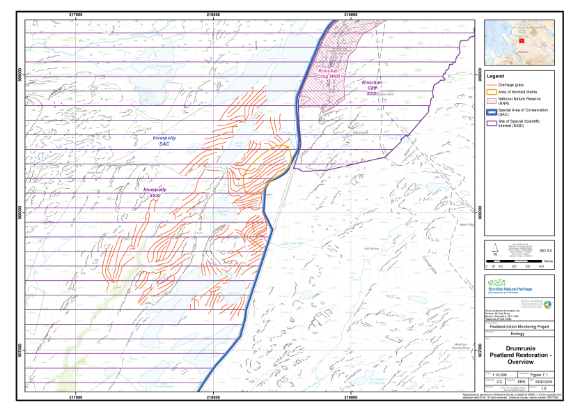
Figure 14. Overview of the designated areas and peatland restoration at Drumrunie
Click for a full description
Drumrunie is shown an OS basemap.
Protected area boundaries are shown:
- Knockan Crag NNR, delineated in red
- Knockan Cliff SSSI and Inverpolly SSSI in orange
- Inverpolly SAC in green.
A filled green polygon shows an area from the Ancient Woodland Inventory.
Drainage grips are shown in purple.
Monitoring strategy
The sampling strategy was designed to monitor the change in vegetation after dam installation had been applied to the blanket bog habitat. Samples were taken equally across three areas, comprising a peat dam area, a plastic dam area and an area that received no dams (the untreated control). Each sample location was allocated an Area code (A, B and C, respectively). The sample plots are outlined below:
- Area A - Drains blocked with plastic dams;
- Area B - Control (unblocked drains); and
- Area C - Drains blocked with peat dams
In each Area a total of 15 2m x 2m quadrats were collected across a homogenous stand of the main vegetation type within the treated area. Quadrats were sampled randomly within the homogeneous vegetation stand. The abundances of all plant species were recorded as percent cover. A number of environmental and vegetation community measurements were also taken, including cover of bare peat, vegetation height and presence of dung (see Annex I for further details).
In addition, single 2m x 2m quadrats were taken behind five separate blocks at each area receiving dams (Areas A and C), again selecting typical examples of the restoration approach.
The quadrat sample set (45 quadrats across Area A, B and C) allows for robust statistical analysis of vegetation community change over time, and also analysis of the effectiveness of peat versus plastic dams. The samples taken behind the ditch blocks (10 quadrats across Areas A and C) can be assessed over time and in relation to the type of dam installed (peat or plastic).
Fixed point photographs of each area were taken to supplement the 2m x 2m quadrat samples.
Monitoring of the restoration measures took place between 9th and 10th September 2014 by Alistair Blackshaw (Senior Ecologist, MCIEEM) and Victoria Burton (Ecologist ACIEEM).
Baseline survey results
Table 8 presents a summary of the plant species recorded in each of the three sample areas along with their abundance (DAFOR scale). Quadrat data are presented in Annex II and their locations shown in Figure 15. The fixed point photographs are presented within Annex III and their locations shown on Figure 16. Each sample area is described below.
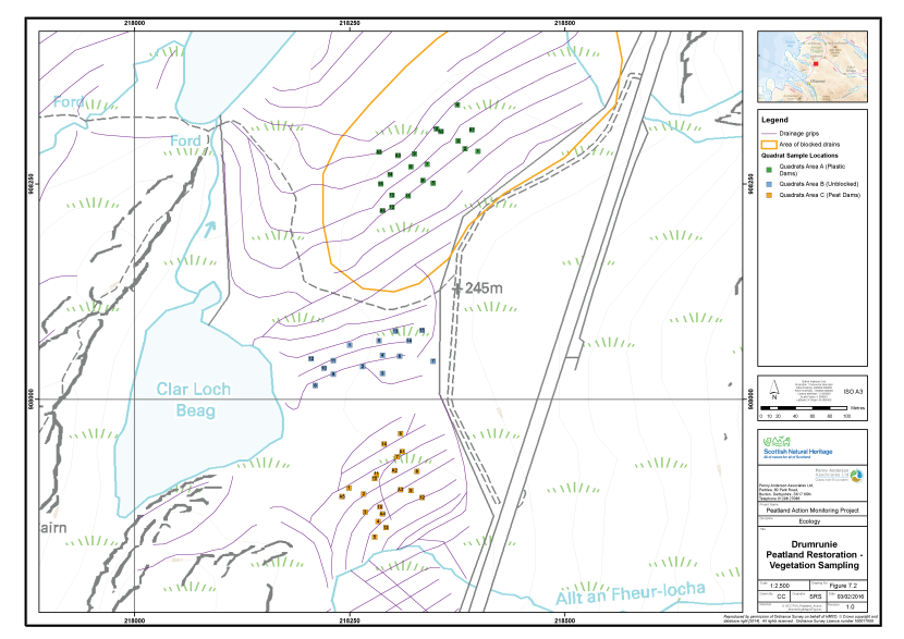
Figure 15. The vegetation survey quadrat locations at Drumrunie
Click for a full description
Drumrunie on an OS basemap.
Drainage grips are shown in purple.
The locations of three clusters of vegetation survey quadrats are shown as numbered squares:
- Area A, in green
- Area B, in blue
- Area C, in orange.
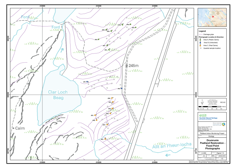
Figure 16. The locations of fixed point photography at Drumrunie
Click for a full description
Drumrunie on an OS basemap.
Drainage grips are shown in purple.
The locations of three clusters of fixed point photography points are shown as filled circles with arrows indicating the direction the photographer faced.
- Area A, in Phase 1 in green
- Area B, in Phase 3 in blue
- Area C, Phase 4 in orange.
Table 8. Abundance of plants recorded in the sample plots, Drumrunie, 2014
|
Common Name |
Scientific Name |
Area A |
Area B |
Area C |
|---|---|---|---|---|
|
Bog-asphodel |
Narthecium ossifragum |
F |
F |
F |
|
Bog-myrtle |
Myrica gale |
O |
O |
O |
|
Bottle sedge |
Carex rostrata |
- |
R |
- |
|
Common cottongrass |
Eriophorum angustifolium |
O |
O |
O |
|
Cross-leaved heath |
Erica tetralix |
O |
- |
F |
|
Crowberry |
Empetrum nigrum |
R |
- |
- |
|
Deergrass |
Trichophorum germanicum |
F |
F |
F |
|
Fir clubmoss |
Huperzia selago |
R |
O |
R |
|
Great sundew |
Drosera anglica |
R |
- |
R |
|
Hare's-tail cottongrass |
Eriophorum vaginatum |
F |
A |
F |
|
Heath milkwort |
Polygala serpyllifolia |
- |
R |
R |
|
Heather |
Calluna vulgaris |
F |
F |
F |
|
Louswort |
Pedicularis sylvatica |
- |
R |
R |
|
Purple moor-grass |
Molinia caerulea |
- |
F |
F |
|
Round-leaved sundew |
Drosera rotundifolia |
R |
- |
R |
|
Tormentil |
Potentilla erecta |
- |
- |
O |
|
A bog moss |
Sphagnum capillifolium ssp rubellum |
F |
F |
O |
|
A bog moss |
Sphagnum compactum |
- |
O |
- |
|
A bog moss |
Sphagnum fallax |
R |
- |
- |
|
A bog moss |
Sphagnum palustre |
- |
R |
- |
|
A bog moss |
Sphagnum papillosum |
O |
O |
O |
|
A bog moss |
Sphagnum subnitens |
R |
R |
- |
|
A bog moss |
Sphagnum tenellum |
O |
O |
O |
|
A lichen |
Cladonia arbuscula |
O |
F |
O |
|
A lichen |
Cladonia uncialis |
R |
F |
O |
|
A liverwort |
Pleurozia purpurea |
- |
R |
F |
|
A moss |
Hypnum jutlandicum |
- |
- |
O |
|
A moss |
Racomitrium lanuginosum |
F |
F |
F |
Area A – M17 Bog with plastic dams
This area of M17 Scirpus cespitosus – Eriophorum vaginatum blanket bog has some minor hagging and isolated areas of eroding gullies but more significantly is densely gripped at approximately 20m intervals. The peat was saturated and soft at the time of survey despite the artificial drainage and localised erosion.
The vegetation is good quality blanket bog with some hummock/hollow and pool formations. Deer-grass, hare’s-tail cottongrass, heather and bog-asphodel are all frequent along with occasional cross-leaved heath, common cottongrass and rare sundew (Drosera rotundifolia), fir club-moss (Huperzia selago) and bog-myrtle (Myrica gale). Sphagnum mosses are abundant with the main species being S. papillosum and S. tenellum along with frequent S. capillifolium ssp. rubellum and more rarely S. subnitens and S. fallax. In addition, Sphagnum cuspidatum and S. denticulatum were recorded within the drains. Racomitrium lanuginosum and Pleurozium purpurea are also frequent across the sample area.
The grip blocks were generally well placed and holding water to ‘bank full’, particularly on the flatter areas as might be expected. Colonisation by aquatic species (Sphagnum cuspidatum and S. denticulatum) was already evident in the pools behind the dams and appeared to be better within those areas with peat added.
A total of 15 quadrats were taken within this vegetation type along with five quadrats behind the grip blocks to assess the revegetation of the drains over time. Eight fixed point photograph points were set up, including both the grip blocks and general sample areas.
Area B – Control (M17 Bog with unblocked drains)
This area of M17 Scirpus cespitosus – Eriophorum vaginatum blanket bog was visibly drier that Area A, although it is also located on a more sloping part of the site which will have some impact on the habitat. The vegetation is similar to Area A with the addition of purple moor-grass which likely reflects the increased water movement through the peat in this area (which favours this species) – a result of natural topography enhanced by the artificial drainage. The sample area lacks sundews and Sphagnum species more typical of wetter sites.
The water level in the grips suggests the water table is 35 – 40cm below the peat surface near to the grip. This effect lessens further away from the grips and water tables appear to be maintained at surface level in the centre between two grips. This is a well reported effect of water table drawdown close to drains on peatlands.
A total of 15 quadrats were taken within this vegetation type along with two fixed point photograph points to illustrate the general sample area.
Area C – M17 Bog with peat dams
This sample area of M17 Scirpus cespitosus – Eriophorum vaginatum blanket bog is similar in vegetation to Area B, with purple moor-grass occurring within the matrix of heather, hare’s-tail cottongrass, cross-leaved heather and sundews. The presence of a more diverse range of Sphagnum along with Pleurozia purpurea shows similarities to Area A.
The drains are approximately 0.5m wide and spaced at between 5m and 15m intervals resulting in a heavily gripped area. They are now dammed with peat. The dams are generally holding water, although a number are being circumvented by water flow as they are level with (rather than slightly proud of) the bog surface. This is leading to erosion in some cases and needs careful monitoring. There is very little observable damage from the installation process.
Behind the dams there is some colonisation of common cotton-grass but Sphagnum colonisation is relatively sparse at present, particularly in comparison to the plastic dams. This may be due to the higher rate of flow continuing down the drain, due to overtopping and circumvention of the dams. Areas where peat was taken to construct the dams have largely become colonised by common cottongrass with little bare peat remaining.
A total of 15 quadrats were taken within this vegetation type, along with eight fixed point photograph points to illustrate the general sample area.
Constraints on survey
No significant constraints were identified during the survey. All areas of the site were accessible and the selection of sample areas was relatively straightforward.
The site is adjacent to the A835. A large lay-by provides ample parking and the site is gained in around 5 minutes on foot from here.
Assessment of restoration approach
The restoration approach is highly likely to show a positive result, for although the site was already quite wet the installation of the dams will prevent further erosion damage and encourage colonisation of pools of water by a range of aquatic species (as is already observed).
The peat dams are functioning well, however, there is regular water flow over and around the dams, which is in some cases leading to erosion. This should be carefully monitored and remedial action may be required. The peat dams would have benefitted from being slightly more proud of the peat surface and also having a small ‘spillway’ (a very shallow channel to move water away from behind the dam and onto the main bog area) at the side to take water onto the main bog area to allow it to dissipate at times of high flow (rather than overtop or erode around the dams). Similar ‘spillways’ would also be beneficial next to the plastic dams, again to reduce risk of erosion around the dams at times of high flow.
A re-survey in 2016 would be a suitable timeframe for monitoring, along with more regular on-going monitoring and maintenance of the dam integrity.
Edinglassie
Overview of the site
Edinglassie is situated approximately 6km south-east of Dufftown, Morayshire. The restoration site is not subject to any statutory nature conservation designations. The site is part of a sporting estate and the predominant management activity across the wider area is burning heather to sustain commercial red grouse (Lagopus lagopus subsp. scotica) populations. The site comprises two distinct areas (Figure 17).
The Scalp comprises a former peat cutting up to approximately 3m, situated on a high plateau (c.470m alt.). To the east of the cutting is relatively unmodified M19 blanket bog. Peat has been cut eastwards from the western edge of the hill, such that to the west of the cutting little peat remains and the mineral soil is frequently exposed. The vegetation here is dry dwarf-shrub heath, dominated by heather. The peat cutting was used historically for smoking by the local whisky distilleries and for domestic burning, but is no longer exploited.
The Swiles of Glen Markie lie at the head of the Markie Water valley, to the south of The Scalp. The area comprises M19 blanket bog dominated by hare’s-tail cottongrass, heather, Sphagnum capillifolium subsp. rubellum and Cladonia portentosa. Moor drains following a herring bone pattern were installed here in the past in an attempt to reduce the water table in the blanket bog at the head of the valley, presumably to increase its value for grouse rearing or livestock grazing.
Existing monitoring on site
A number of dipwells were present in the Swiles of Glen Markie area. These suggested that a hydrological monitoring regime is in place on this part of the site, however, no further details of this or any other monitoring schemes were supplied by NatureScot.
Restoration measures undertaken
Peatland restoration at Edinglassie was undertaken during 2014 and 2015 and comprised the following:
- Re-profiling of haggs and former peat cuttings and subsequent patching with turves, at the northern site (The Scalp);
- Covering of bare peat at The Scalp with mulch harvested from nearby blanket bog; and
- Re-profiling, flattening and blocking of moor drains with peat dams at the southern site (Swiles of Glenmarkie).
Monitoring of the restoration measures was carried out between 23rd and 25th June 2015 by Alistair Blackshaw (Senior Ecologist, MCIEEM) and Victoria Burton (Ecologist, ACIEEM). The monitoring strategy implemented is discussed below.
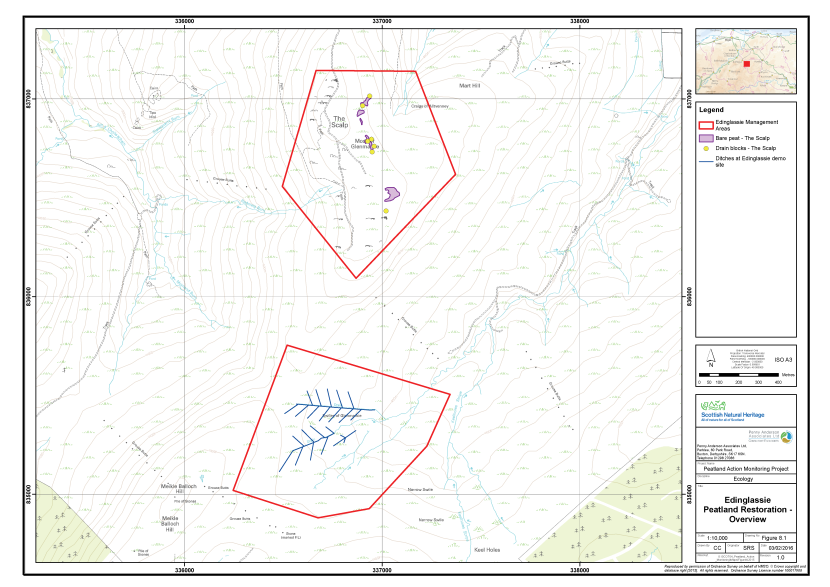
Figure 17. Overview of the peatland restoration conducted at Edinglassie
Click for a full description
Two areas of peatland restoration at Edinglassie are delineated in red on an OS basemap.
Restoration features comprise:
- Areas of bare peat, represented by purple polygons;
- Drain blocks, represented by filled yellow circles;
- Ditches, represented by bleu lines.
Monitoring strategy
The sampling strategy was designed to monitor change in vegetation post treatment. Samples were taken equally across the three treatment types. A further sample of the unblocked gullies and short grips in the Swiles of Glen Markie area was taken to provide a control plot. This will allow factors external to the treatment, for example climatic variations and day to day management, to be allowed for in future assessments and thus provide greater confidence in that any changes in the vegetation are due to drain blocking. In addition, a sample was recorded in an area of good quality blanket bog, to provide a reference plot. Future monitoring datasets can be compared to the reference, to provide an assessment of the treatments in terms of their effectiveness to promote vegetation change in the towards a locally typical blanket bog community. The sample areas were as follows:
- Area A - Re-profiled and patched former peat cutting (Post-treatment sample);
- Area B - Mulched bare peat basin (Post-treatment sample);
- Area C - Blocked and flattened drains (Post-treatment sample);
- Area D - Unblocked gullies (Control);
- Area E - Untreated and relatively unmodified blanket bog (Reference); and
- Area F - Mulched bare peat at base of former peat cutting (Post-treatment sample).
In each of Areas A, B, C, D and E a total of 15 2m x 2m quadrats were collected across a homogenous stand of the main vegetation type within the treated area. Quadrats were sampled randomly within the homogeneous vegetation stand. The abundances of all plant species were recorded as percent cover. A number of environmental and vegetation community measurements were also taken, including cover of bare peat, vegetation height and presence of dung (see Annex I for further details). A further plot, Area F, comprising bare peat at the foot of the main peat cutting was sampled through fixed point photography only, to provide a visual record of the post-treatment vegetation.
The quadrat survey targeted several aspects of the restoration approaches, which varied by Area. In Area A, the turves patched on to the re-profiled cutting were sampled, to provide a post-treatment baseline to allow assessment of whether they persist and change over time. In Area B mulched bare peat was targeted to provide a baseline against which success of the mulching treatment could be assessed in the future. In areas C and D, the area within approximately 15m of the main drains/gullies was sampled. To provide a reference site (Area E), the site was searched for a relatively unmodified stand of blanket bog vegetation and this was sampled.
Sampling was undertaken approximately six to eight months after management had been completed. The dataset gathered, therefore, provides a post-treatment baseline for future monitoring of change in the vegetation. The quadrat sample set (75 quadrats across Area A, B, C, D and E) allows for robust statistical analysis of change in the vegetation communities change over time.
Fixed point photographs of each sample plot were taken to supplement the 2m x 2m quadrat samples.
Baseline survey results
Table 9 presents a summary of the plant species recorded in each of the four sample plots along with their abundance (DAFOR scale). Quadrat data are presented in Annex II and their locations area shown on Figure 18. The fixed point photographs are presented within Annex III and their locations shown on Figure 19. Each sample area is described below.
Table 9. Abundance of plants recorded in the sample plots, Edinglassie, 2015
|
Common Name |
Scientific Name |
Area A |
Area B |
Area C |
Area D |
Area E |
Area F |
|---|---|---|---|---|---|---|---|
|
Bilberry |
Vaccinium myrtillus |
F |
- |
- |
- |
- |
- |
|
Bog asphodel |
Narthecium ossifragum |
- |
- |
F |
R |
- |
- |
|
Cloudberry |
Rubus chamaemorus |
R |
- |
R |
- |
- |
- |
|
Cross-leaved heath |
Erica tetralix |
- |
- |
F |
O |
O |
- |
|
Crowberry |
Empetrum nigrum |
F |
- |
R |
O |
O |
- |
|
Deergrass |
Trichophorum germanicum |
- |
- |
F |
F |
R |
- |
|
Hare's-tail cottongrass |
Eriophorum vaginatum |
A |
O |
A |
A |
A |
R |
|
Heather |
Calluna vulgaris |
A |
- |
A |
A |
A |
- |
|
Heather (dead) |
Calluna vulgaris (dead) |
F |
- |
- |
- |
- |
- |
|
Lesser twayblade |
Neottia cordata |
R |
- |
- |
- |
O |
- |
|
Round-leaved sundew |
Drosera rotundifolia |
F |
- |
- |
R |
O |
- |
|
Sheep's sorrel |
Rumex acetosella |
O |
- |
- |
- |
- |
- |
|
A moss |
Aulacomnium palustre |
F |
R |
- |
- |
- |
R |
|
A moss |
Hylocomium splendens |
A |
- |
O |
- |
R |
- |
|
A moss |
Hypnum jutlandicum |
A |
- |
F |
O |
F |
- |
|
A moss |
Pleurozium schreberi |
F |
O |
F |
O |
F |
R |
|
A moss |
Polytrichum commune |
F |
- |
- |
- |
- |
- |
|
A moss |
Racomitrium lanuginosum |
- |
- |
- |
R |
- |
- |
|
A moss |
Rhytidiadelphus loreus |
O |
R |
- |
- |
R |
- |
|
A moss |
Rhytidiadelphus squarrosus |
O |
R |
- |
- |
- |
R |
|
A liverwort |
Diplophyllum albicans |
- |
- |
O |
- |
- |
- |
|
A liverwort |
Mylia anomala |
- |
- |
R |
- |
- |
- |
|
A liverwort |
Mylia taylorii |
- |
- |
O |
- |
- |
- |
|
A bog moss |
Sphagnum capillifolium |
- |
- |
- |
- |
- |
- |
|
A bog moss |
Sphagnum capillifolium subsp capillifolium |
- |
- |
- |
F |
F |
- |
|
A bog moss |
Sphagnum capillifolium subsp rubellum |
- |
R |
F |
O |
O |
R |
|
A bog moss |
Sphagnum compactum |
- |
- |
- |
R |
- |
- |
|
A bog moss |
Sphagnum cuspidatum |
- |
- |
LF |
- |
- |
- |
|
A bog moss |
Sphagnum magellanicum |
- |
- |
- |
R |
- |
- |
|
A bog moss |
Sphagnum palustre |
- |
- |
O |
- |
- |
- |
|
A bog moss |
Sphagnum papillosum |
- |
- |
O |
O |
O |
- |
|
A bog moss |
Sphagnum subnitens |
- |
- |
- |
O |
- |
- |
|
A bog moss |
Sphagnum tenellum |
- |
- |
O |
R |
- |
- |
|
A lichen |
Cladonia arbuscula |
- |
- |
O |
- |
F |
R |
|
A lichen |
Cladonia portentosa |
- |
O |
A |
A |
- |
- |
|
A lichen |
Cladonia uncialis |
- |
- |
R |
- |
- |
- |
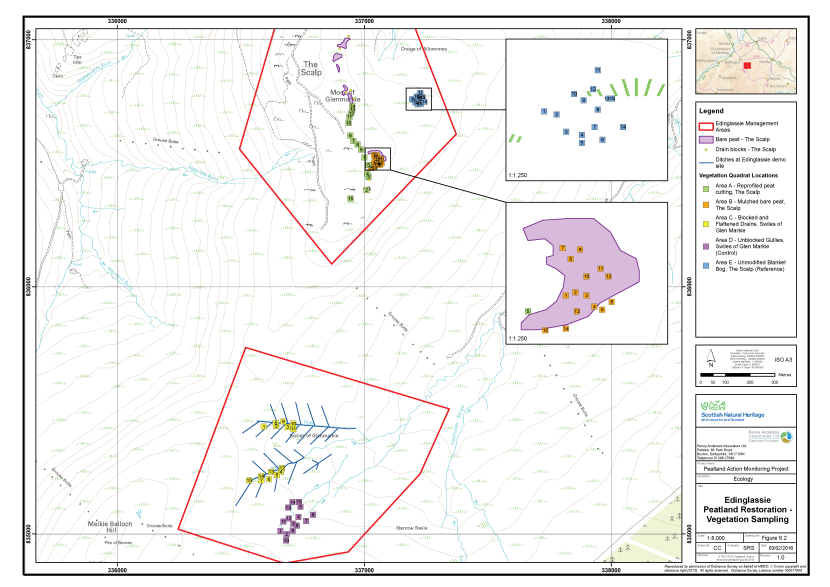
Figure 18. The vegetation survey quadrat locations at Edinglassie
Click for a full description
Two areas of peatland restoration at Edinglassie are delineated in red on an OS basemap.
Restoration features comprise:
- Areas of bare peat, represented by purple polygons;
- Drain blocks, represented by filled yellow circles;
- Ditches, represented by bleu lines.
The locations of five clusters of vegetation survey quadrats are shown as filled, numbered squares:
- Area A, in green, reprofiled peat cutting, The Scalp
- Area B, in orange, mulched bare peat, The Scalp;
- Area C, in yellow, blocked and flattened drains, Swiles of Glenmarkie;
- Area D, in purple, unblocked gullies, Swiles of Glenmarkie (control);
- Area E, in blue, unmodified blanket bog, The Scalp (reference).
Two of the clusters are linked to inset maps, which show a zoomed in view of the vegetation survey quadrat locations, and shows the quadrat numbers.
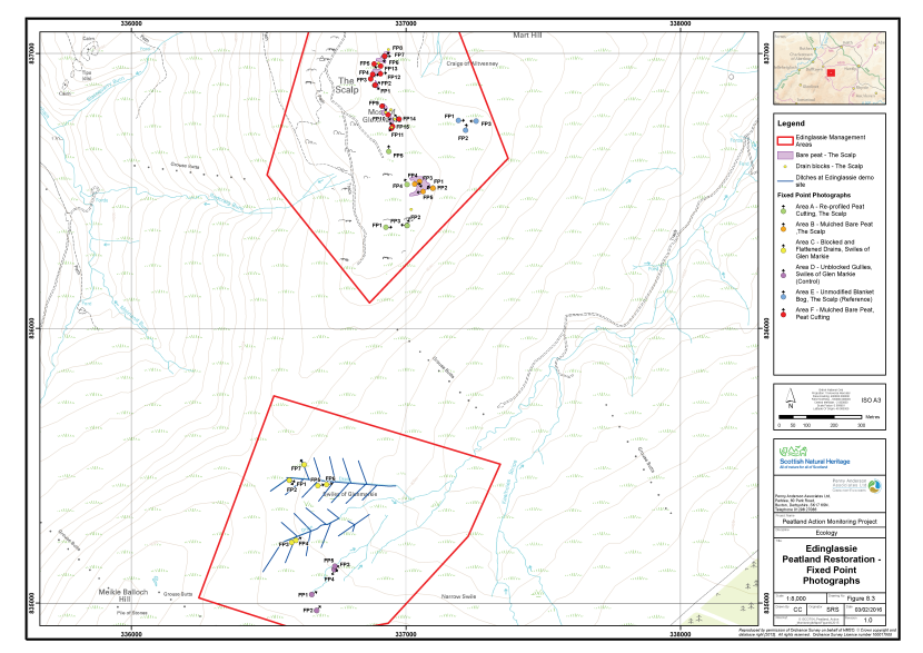
Figure 19. The locations of fixed point photography at Edinglassie
Click for a full description
Two areas of peatland restoration at Edinglassie are delineated in red on an OS basemap.
Restoration features comprise:
- Areas of bare peat, represented by purple polygons;
- Drain blocks, represented by filled yellow circles;
- Ditches, represented by blue lines.
The locations of six clusters of fixed point photography locations are shown as filled, circles with arrows indicating the direction the photographer faced:
- Area A, in green, reprofiled peat cutting, The Scalp
- Area B, in orange, mulched bare peat, The Scalp;
- Area C, in yellow, blocked and flattened drains, Swiles of Glenmarkie;
- Area D, in purple, unblocked gullies, Swiles of Glenmarkie (control);
- Area E, in blue, unmodified blanket bog, The Scalp (reference);
- Area F, in red, mulched bare peat and peat cutting.
Area A - Re-profiled peat cutting (The Scalp)
Area A comprised an approximately 500m long peat cutting. The majority of the cutting faces west, although a short section at its southern end faces north. Peat has been stripped away from west to east over many years, leaving a thin layer of peat, with exposed mineral soil in places, to the west of the cutting. The vegetation here comprised even-aged heather which appeared to have regenerated after a fire approximately 15 years ago. The bleached trunks of young Scots pine, killed by the fire were still present. The frequent islands of vegetated peat within this area are not vestiges of the former bog surface, but piles of turves discarded when the peat sods were removed.
Prior to treatment, the cut face was a mixture of bare peat, together with overhanging and detached turf originating from the top of the cutting. This vegetation comprised dry heather-dominated blanket bog with hare’s-tail cottongrass, crowberry, bilberry and some cloudberry (Rubus chamaemorus). Sphagnum mosses were relatively scarce close to the cutting, but where the water table increased away from the cut face, it increased in abundance.
The restoration measures applied to this area have sought to re-profile the cutting to a less steep angle, a maximum of around 45°, to allow the establishment of vegetation cover. In order to prevent further erosion of the cut face and expedite re-colonisation, the bank had been patched with living turves won either from the overhanging mats of vegetation during re-profiling or stripped from the intact bog behind the cutting. Stripping from the bog to the east had evidently been increased in areas where there had been sparse overhanging vegetation.
Area B - Mulched bare peat (The Scalp)
Area B comprised an irregularly shaped south-east facing bowl of bare peat, approximately 75m x 35m at its widest points. The bowl drains south-eastwards; water collects at the edge feature and deposits suspended peat before draining to the blanket bog below. The outflow has no significant gullies associated with it. Peat within the bowl feature is up to 0.5m deep.
The large expanse of bare peat, which has been eroded way to mineral soil in two places, is suggestive of disturbance in the past. Remaining pedestals of peat, up to 0.75m high, indicate that fire may have been a factor in the degradation of this area.
The restoration method applied to the area has sought to cover the bare peat and provide a source of propagules to expedite the colonisation process. Both of these objectives have been addressed through the application of a much consisting material harvested from the blanket bog to the west, close to Area E.
Area C - Blocked and flattened drains (Swiles of Glen Markie)
The Swiles of Glen Markie is a large bowl-shaped feature which comprises the upper part of the Markie Water catchment. The peat is very wet and consistently greater than 1.0m deep. The area has been drained in a regular herring bone pattern to extend two tributaries of the natural drainage system further into the deeper accumulation of blanket peat at the head of the catchment. Each natural tributary has a main drain approximately 1.5m wide and tributary drains up to around 1m wide, although most had been closed over by the restoration treatment.
The northern part of the area is burnt as part of the grouse moor, but the area to the south of the northern drain had not been recently burnt. Vegetation throughout the drained area comprised M19 blanket bog with hare’s-tail cottongrass, heather, cloudberry and abundant Cladonia portentosa and Hylocomium splendens. Sphagnum species were generally of low abundance and no species was constant throughout, as would be expected in a stand of unmodified bog. The increased dominance of heather and graminoids suggested that the drains had at least partially altered the hydrology of the peat, making it drier.
The restoration method applied to the area has sought to prevent flow within the tributary drains by flattening their extremities. Further down the system, where the drains were wider, and on the main drains themselves, the banks have been flattened and peat dams installed at regular intervals to stem water flow, promote pooling and raise the water table in peat adjacent to the drains.
Area D - Control (Unblocked gullies, Swiles of Glen Markie)
Area D comprises the southern part of the Swiles of Glen Markie. The area has not been drained, but is characterised by two deep eroding gullies, which extend further back into the deep blanket peat than the natural drainage features in Area C. Although no moor grips have been installed here, the area was considered analogous to gripped moorland due to the increased drainage effect of the gullies. Vegetation comprised M19 blanket bog, of a similar composition to Area C, but with more frequent Racomitrium lanuginosum.
This site was sampled to allow monitoring of the ‘do nothing’ case, in respect of blocking the drains. It will also allow factors external to the treatment, for day to day management, to be taken into account in future assessments and thus provide greater confidence in that any changes observed in the vegetation of Area C are due to the drain blocking treatment rather than any other factors.
Area E - Reference (Unmodified blanket bog, The Scalp)
Area E comprises relatively unmodified blanket bog vegetation that was considered to be a suitable reference site to the vegetation present in the Swiles of Glen Markie (Areas C and D), but in a less modified state. The main differences in the vegetation were increased abundance and frequency of Sphagnum capillifolium subsp. rubellum and Pleurozium schreberi and less deergrass and Racomitrium lanuginosum.
This area was sampled in order to provide a reference against which recovery of the treated area of the Swiles of Glenmarkie (Area C) can be measured in the future. Comparison of both the treated area and the untreated area (Area D) to the reference will allow assessment of whether the flattening and blocking treatment causes vegetation in the drained blanket bog vegetation to become more similar to relatively unmodified bog, typical of the local area.
Area F - Bare peat at base of cutting (The Scalp)
This sample area comprised the bare peat at the base of the former peat cutting. Mulch had been applied to bare peat associated with the cutting, where it had not been possible to carry out patching work with stripped turves, probably due to a lack of available turf for patching. This treatment was, therefore, very similar to Area B and it was considered that an appropriate sample had already been gained in that area. Nevertheless, the area was sampled with fixed point photography to provide a repeatable visual assessment of the treatment.
Constraints on survey
No significant constraints on the survey were noted. Please note that a 4x4 vehicle with good ground clearance is essential for access to the site. Mud tyres are also advised as the access track crosses very wet peat in places. To drive in to The Scalp from the A920 takes around 35 minutes with an additional 5-10 minutes to the parking for the Swiles of Glen Markie area. From the parking, it is a 35 minute walk to Areas C and D.
The approach to the site lies close to the Tips of Causemaul and Tom Mòr, which is designated as a Special Area of Conservation (SAC) and an SSSI for its internationally important breeding population of common gull (Larus canus) (SNH 2011b). The gulls do not appear to be disturbed by vehicles on the lower part of the track, but it is important not to get out of the vehicle here during the breeding season if avoidable.
Assessment of restoration approach
Future monitoring datasets will enable post-treatment change in the vegetation of the re-profiled peat cutting (Area A) and mulched bare peat (Area B) to be monitored in detail. In addition to change over time further assessment will be possible in addition for the Swiles of Glen Markie. Here, it will be possible to compare change in the treated area (Area B) with both a control site (Area D) and a reference site (Area E).
The restoration measures implemented for the peat cutting (Area A) are considered likely to be successful. In some places mature heather that has been translocated with the turves has not survived as well as the younger bushes. Provided there is a viable seed bank within the turves, this is considered unlikely to be a long term problem. A tendency towards heather-dominated vegetation is considered likely, as the blanket bog species translocated with the turves are out-competed in the drier peat conditions. This is not considered a major shortcoming, as the aim of the treatment was to prevent further weathering of the cutting.
Long-term success of the mulching treatment (Areas B and F) was considered uncertain. The mulch layer had been broken up and spread around by the weather and hydrological processes since application (see Annex III), leaving some areas with significant accumulations of mulch and some areas with none at all. Regeneration of vegetation fragments applied with the mulch was found to be very sparse and growing vegetation comprised <1% of the treated areas. The most often encountered regenerating species within Area B were hare’s-tail cottongrass and the mosses Pleurozium schreberi and Rhytidiadelphus loreus. In area F, the most frequent species was sheep’s sorrel which is characteristic of dry acidic habitats and is unlikely to have been introduced with the mulch.
The restoration approach adopted for the Swiles of Glen Markie (Area C) is highly likely to show a positive result. Although the site was probably already quite wet, the dams had largely stopped water flow in the drains, resulting in pooling and a consequently raised water table. The survey was carried out too soon after damming for any colonisation of the pools behind the dams to be recorded. The peat dams were generally functioning well, however, water flow over and around a number of dams on the main drains was observed, in some cases leading to erosion. This should be carefully monitored and remedial action taken where required.
Although the re-profiled and patched sides of the drains were re-vegetating well, there were some areas where turf had been intensively stripped adjacent to the drain. This had resulted in an increased risk of run-off from the disturbed areas which could erode the intact vegetation and peat between the stripped areas.
It is recommended that condition of the peat dams is monitored in 2016 and remedial action taken to prevent washing-out if necessary. A walkover inspection of the mulched areas should also be carried out.
A re-survey of the site in 2017 would be a suitable timeframe for monitoring, along with the interim monitoring measures proposed above.
Glen Ey
Overview of the site
Glen Ey is situated approximately 13km south-west of Braemar, in Aberdeenshire. The site lies within the Cairngorms Massif Special Protection Area (SPA), which is of international importance for its breeding population of golden eagle (SNH 2010a). Part of the Ey Burn is included within the River Dee SAC, which is of international importance for Atlantic salmon, otter (Lutra lutra) and freshwater pearl mussel. Glen Ey Gorge is designated separately as an SSSI and is of national importance for its geology and also for its upland grassland and cliff ledge vegetation (SNH 2011c).
The Glen Ey restoration site is situated at the head of the Ey Burn, at approximately 650m - 770m altitude, between Carn Bach and Beinn Lutharn Mhôr. The site is part of a sporting estate and the predominant management activity across the wider area is burning heather to sustain red grouse populations for driven shooting. The vegetation of the site comprises M19 blanket bog dominated by hare’s tail cotton-grass and heather, with varying quantities of Sphagnum capillifolium sensu lato on peat that is generally greater than 1m deep. The site is degraded due to extensive hagging and gullying of the peat and the drying effect this has had on the vegetation. The damage has probably been caused by long-term grazing and burning of the site.
Existing monitoring on site
Information received from NatureScot does not indicate whether there is any ongoing hydrological or vegetation monitoring of the site. A Restoration Plan, dividing the site into four ‘Sections’ (Figure 20) was prepared in 2014 (Corcoran 2014).
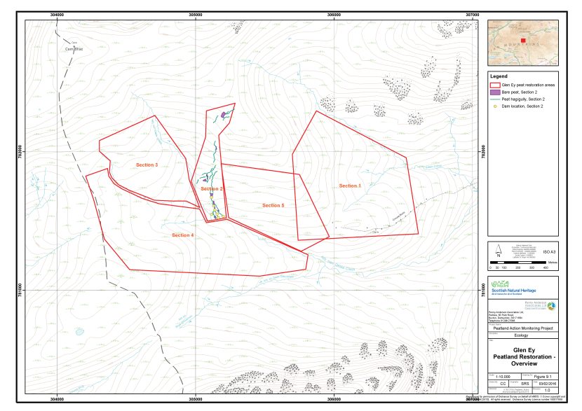
Figure 20. Overview of the peatland restoration conducted at Glen Ey
Click for a full description
Five areas of peatland restoration at Glen Ey are delineated in red on an OS basemap.
Restoration features are drawn in section 2 and comprise:
- Areas of bare peat, represented by purple polygons;
- Peat haggs and gullies, represented by green lines;
- Dams, represented by yellow filled circles.
Restoration measures undertaken
Monitoring of the restoration measures took place between 7th and 9th July 2015 by Alistair Blackshaw (Senior Ecologist, MCIEEM) and Victoria Burton (Ecologist Grad CIEEM).
Restoration of the peatland was under way as the survey took place. Section 2 had been completed in the winter prior to the survey (2014/2015); after this, work had been halted by bad weather. Work had resumed not long before the survey within a new area not included in the original Restoration Plan. This area, Section 5, lies between Sections 1 and 2. The original Peatland Action application for the site stated that the following measures would be implemented to restore the peatland:
- On areas of bare peat, where the slope is below 40°, double cut heather brash will be spread across the surface. Fertilizer and lime will be applied across the surface and nursery seed mix scattered. In very wet areas Sphagnum species may be applied to the brash as well if they can be sourced locally.
- On steeper areas of bare peat, geo-textile matting is to be laid down and pinned in place with degradable pegs. Fertilizer and a nursery crop seed mix will be applied.
- The eroded gullies and peat haggs will receive a combination of heather brash and geo-textile matting as well as fertilizer and nursery crop seed mix.
- Some of the gullies require small dams to prevent further wash-out of peat into the watercourses. Stone dams are to be built in these (timber dams could also be built but there is an abundance of stone locally).
The techniques used on site up to the date of the survey differed from the original plan outlined above. Discussion with the contractor suggested that the former plan had been simplified. The main restoration method to be implemented was extensive re-profiling of the gullies and haggs using excavators and subsequent turfing to cover any remaining bare peat. Significant areas of bare peat, remaining due to a lack of turf won from re-profiling, would be mulched with material harvested from the surrounding intact blanket bog. There were no plans to use lime, seed and fertiliser, heather brash, geojute or stone and wooden dams, however, some peat bunds had been created within a number of gullies where the contractor had felt it was appropriate to do so.
Monitoring strategy
The sampling strategy was adapted to take account of the progress of the work. As work was ongoing in Section 5, the only treated areas available for Sampling were in Section 2.
The sampling strategy was designed to monitor change in the vegetation of Section 2 post treatment. An untreated control plot was also sampled. This will allow factors external to the re-profiling treatment, for example climatic variations and day to day management, to be allowed for in future assessments, and thus provide greater confidence in that any changes in the vegetation are due to re-profiling. In addition, a sample was recorded in an area of good quality blanket bog, to provide a reference plot. Future monitoring datasets can be compared to the reference, to provide an assessment of the treatments in terms of their effectiveness to promote vegetation change in the towards a locally typical blanket bog community.
A total of six samples were taken, each allocated an Area code (A, B, C, D, E and F respectively). Three of the sample plots had undergone some restoration work already, however, the final treatment had been applied to Area A only. The Areas are outlined below:
- Area A - Re-profiled and patched gullies (Post-treatment sample);
- Area B - Re-profiled bare peat trough prior to treatment with mulch (Pre-treatment baseline);
- Area C - Re-profiled gully sides prior to treatment with mulch (Pre-treatment baseline);
- Area D - Untreated relatively unmodified bog (Reference);
- Area E - Untreated haggs/gullies (Control); and
- Area F - Untreated haggs/gullies (Pre -treatment baseline).
In each of Areas A, B, C, D and E a total of 15 2m x 2m quadrats were collected across a homogenous stand of the main vegetation type within the treated area. Quadrats were sampled randomly within the homogeneous vegetation stand. The abundances of all plant species were recorded as percent cover. A number of environmental and vegetation community measurements were also taken, including cover of bare peat, vegetation height and presence of dung (see Annex I for further details).
The quadrat survey targeted several aspects of the restoration approaches, which varied by Area. In Area A, the turves patched on to the re-profiled gully sides were sampled, to provide a post-treatment baseline to allow assessment of whether they persist and change over time. In Areas B and C, bare peat was targeted to provide a baseline against which success of the mulching treatment could be assessed in the future. In area F, bare peat was targeted to provide a baseline against which success of the re-profiling treatment could be assessed in the future. In Area E the bare peat gully sides were targeted to provide a sample of an untreated example of this feature, to which vegetation development within the treated examples could be compared. To provide a reference site (Area D), the site was searched for a relatively unmodified stand of blanket bog vegetation and this was sampled.
Sampling of the treated areas was undertaken approximately nine months after management had been completed. The dataset gathered provides a pre-treatment baseline and first sample post-treatment for the re-profiling treatment and a baseline for the mulching treatment in two distinct situations; flat and steeply sloping bare peat. The quadrat sample set (90 quadrats across Area A, B, C, D, E and F) allows for robust statistical analysis of change in the vegetation communities over time.
Fixed point photographs of each sample plot were taken to supplement the 2m x 2m quadrat samples.
Baseline survey results
Table 10 presents a summary of the plant species recorded in each of the four sample areas along with their abundance (DAFOR scale). Quadrat data are presented in Annex II and their locations area shown on Figure 21. The fixed point photographs are presented within Annex III and their locations shown on Figure 222. Each sample area is described below
Table 10. Abundance of plants recorded in the sample plots, Glen Ey, 2015
|
Common Name |
Scientific Name |
Area A |
Area B |
Area C |
Area D |
Area E |
Area F |
|---|---|---|---|---|---|---|---|
|
Bare peat |
n/a |
- |
- |
D |
- |
- |
D |
|
Bilberry |
Vaccinium myrtillus |
- |
- |
- |
F |
F |
A |
|
Bog asphodel |
Narthecium ossifragum |
R |
- |
- |
- |
- |
- |
|
Butterwort |
Pinguicula vulgaris |
R |
- |
- |
- |
- |
- |
|
Cloudberry |
Rubus chamaemorus |
O |
- |
- |
F |
- |
O |
|
Common bent |
Agrostis capillaris |
- |
O |
- |
- |
- |
- |
|
Common cottongrass |
Eriophorum angustifolium |
R |
O |
- |
- |
- |
- |
|
Common cow-wheat |
Melampyrum pratense |
- |
- |
- |
- |
- |
R |
|
Common sedge |
Carex nigra |
- |
- |
- |
- |
F |
O |
|
Cowberry |
Vaccinium vitis-idaea |
- |
- |
- |
O |
- |
R |
|
Cross-leaved heath |
Erica tetralix |
R |
- |
- |
- |
- |
- |
|
Crowberry |
Empetrum nigrum |
O |
- |
R |
F |
- |
O |
|
Deergrass |
Trichophorum germanicum |
F |
- |
R |
- |
F |
- |
|
Hare's-tail cottongrass |
Eriophorum vaginatum |
D |
R |
R |
D |
A |
O |
|
Heath bedstraw |
Galium saxatile |
O |
R |
- |
- |
- |
- |
|
Heath rush |
Juncus squarrosus |
- |
R |
- |
- |
F |
- |
|
Heath woodrush |
Luzula multiflora |
R |
|
- |
- |
- |
- |
|
Heather |
Calluna vulgaris |
A |
F |
R |
A |
A |
A |
|
Marsh violet |
Viola palustris |
R |
- |
- |
- |
- |
- |
|
Mat grass |
Nardus stricta |
- |
- |
- |
- |
- |
O |
|
Stiff sedge |
Carex bigelowii |
- |
- |
- |
O |
- |
- |
|
A moss |
Aulacomnium palustre |
R |
- |
- |
R |
- |
- |
|
A moss |
Campylopus sp. |
- |
- |
- |
- |
R |
- |
|
A moss |
Dicranum scoparium |
- |
O |
- |
- |
- |
- |
|
A moss |
Hylocomium splendens |
- |
- |
- |
F |
- |
- |
|
A moss |
Pleurozium schreberi |
O |
F |
R |
F |
- |
- |
|
A moss |
Polytrichum commune |
- |
- |
- |
- |
O |
- |
|
A moss |
Racomitrium lanuginosum |
- |
- |
R |
F |
F |
F |
|
A moss |
Rhytidiadelphus loreus |
O |
- |
- |
F |
- |
- |
|
A liverwort |
Mylia anomala |
- |
- |
- |
R |
- |
- |
|
A bog moss |
Sphagnum capillifolium subsp capillifolium |
- |
- |
- |
O |
R |
O |
|
A bog moss |
Sphagnum capillifolium subsp rubellum |
F |
- |
R |
- |
F |
- |
|
A bog moss |
Sphagnum denticulatum |
R |
- |
- |
- |
- |
F |
|
A bog moss |
Sphagnum fuscum |
- |
- |
- |
R |
- |
|
|
A bog moss |
Sphagnum palustre |
R |
- |
- |
|
- |
F |
|
A bog moss |
Sphagnum papillosum |
- |
- |
- |
|
O |
- |
|
A bog moss |
Sphagnum subnitens |
- |
- |
- |
R |
- |
- |
|
A bog moss |
Sphagnum tenellum |
R |
- |
- |
|
- |
- |
|
A lichen |
Cladonia portentosa |
O |
- |
R |
F |
- |
O |
|
A lichen |
Cladonia uncialis |
R |
- |
- |
O |
- |
- |
|
A lichen |
Cladonia sp. (crustose) |
- |
O |
- |
- |
R |
R |
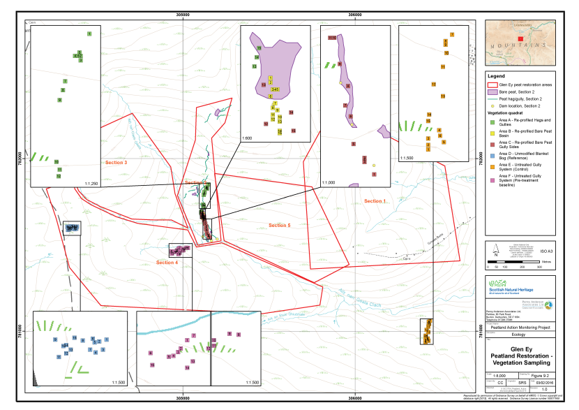
Figure 21. The vegetation survey quadrat locations at Glen Ey
Click for a full description
Five areas of peatland restoration at Glen Ey are delineated in red on an OS basemap.
Restoration features are drawn in section 2 and comprise:
- Areas of bare peat, represented by purple polygons;
- Peat haggs and gullies, represented by green lines;
- Dams, represented by yellow filled circles.
The locations of six clusters of vegetation survey quadrats are shown as filled, numbered squares:
- Area A, in green, reprofiled haggs and gullies;
- Area B, in yellow, reprofiled bare peat basin;
- Area C, in maroon, reprofiled bare peat and gullies;
- Area D, in blue, unmodified blanket bog (reference);
- Area E, in orange, untreated gully system (control);
- Area F, in pink, untreated gully system (pre-treatment baseline).
Each of the clusters are linked to an inset map, which shows a zoomed in view of the vegetation survey quadrat locations in relation to the peatland restoration features.
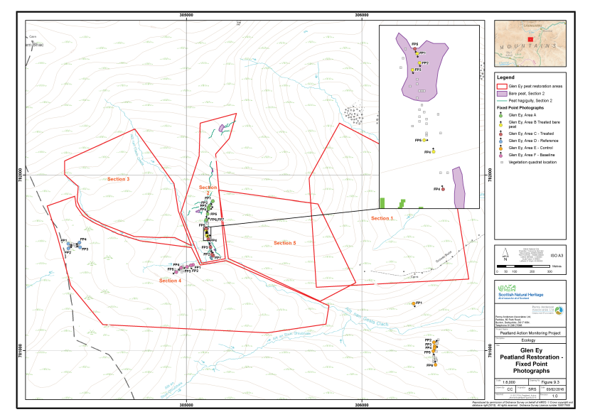
Figure 22. The locations of fixed point photography at Glen Ey
Click for a full description
Five areas of peatland restoration at Glen Ey are delineated in red on an OS basemap.
Restoration features are drawn in section 2 and comprise:
- Areas of bare peat, represented by purple polygons;
- Peat haggs and gullies, represented by green lines;
- Dams, represented by yellow filled circles.
The locations of clusters of fixed point photography locations are shown as filled, circles with arrows indicating the direction the photographer faced:
- Area A, in green;
- Area B, in yellow, treated bare peat;
- Area C, in maroon, treated;
- Area D, in blue, reference;
- Area E, in orange, control;
- Area F, in pink, baseline.
There is an inset map, which shows a zoomed in view of the fixed point photography locations in relation to the peatland restoration features in areas B and C.
Area A - Re-profiled haggs and gullies
This sample plot comprised an approximately 200m long group of gullies and haggs extending north from Area B. Generally, the adjacent vegetation of the area comprised M19 blanket bog dominated by hare’s-tail cottongrass with abundant heather, together with cloudberry and Sphagnum capillifolium subsp. rubellum. The surrounding area is characterised by similar arrangements of gully systems supporting the same vegetation, however there are frequent wide swathes of minerotrophic mire between the eroding ribs of peat.
The gullies had been re-profiled to lessen the severity of their angle to 40-45°, to prevent translocated vegetation and bare peat sliding to the bottom. In order to prevent further erosion of the cut face and expedite re-colonisation, the bank had been patched with living turves won either from the overhanging mats of vegetation during re-profiling or stripped from the intact bog on either side. Stripping from the bog had evidently been increased in areas where there had been sparse overhanging vegetation. Composition of the turves reflected the composition of the adjacent blanket bog.
Occasional peat bunds had been installed near the heads of the gullies; these were not sampled.
Area B - Re-profiled bare peat basin
This sample area comprised an approximately 15m wide by 50m long sloping area of bare peat lying at the confluence of two main gullies which originate upslope, to the north. The gully confluence had been re-profiled and bunded at its southern edge, prior to the survey, to form a trough-like feature. Although the bund was holding some water back, and the upper gullies were relatively dry, a significant flow through the trough and over and around the lower bund was observed. Adjacent vegetation comprised M19 blanket bog as in Area A. The base and side of the trough generally lacked any vegetation although there were some isolated hare’s-tail cottongrass tussocks and heather bushes which had been present in the gully bases prior to re-profiling.
Restoration of this area had not been completed at the time of the survey. The sides of the original gullies had been re-profiled to an angle, of around 40° - 45°. Turf won during the re-profiling process had been placed at the bottom of the east-facing banks of the trough, but the upper parts of the slopes and the base had been left bare. The contractor intended to cover the remaining bare areas with mulch harvested from nearby intact blanket bog within the week after the survey took place (i.e. w/c 13th July). The purpose of the mulch was to act as a source of source of propagules to expedite the process of natural colonisation of the bare peat.
Detailed sampling was undertaken on the bare peat base of the feature only, ignoring the islands of more established vegetation and the bare sides.
Area C - Re-profiled bare peat gully sides
This sample area comprised the lower 200m of the gully system sampled by Areas A and B, just above Allt nan Ciacg Geals. The gully had been re-profiled and partially patched with turves won during this process, together with additional turf harvested from adjacent vegetation. The re-profiled gully was 2m wide at its base, with the bank tops 10m apart.
Restoration of this area had not been completed at the time of the survey. The sides of the original gullies had been re-profiled to an angle, of around 40° - 45°. Turf won during the re-profiling process had been placed at the bottom of the banks, but for most of the gully’s length, the upper parts of the banks had been left bare. The contractor was intending to cover the remaining bare areas with mulch harvested from nearby intact blanket bog within the week after the survey took place (i.e. w/c 13th July). The purpose of the mulch was to act as a source of source of propagules to expedite the process of natural colonisation of the bare peat.
Detailed sampling was undertaken on the bare peat on the upper parts of the banks of the gully only. The translocated turves were not sampled as this restoration method was recorded in Area A.
Area D - Reference
This sample area comprised M19 blanket bog vegetation in relatively unmodified condition. Although peat depth was recorded as only around 0.75m on average, the area comprises the largest intact (un-gullied) body of peat in the area. The vegetation was dominated by hare’s-tail cottongrass with heather, bilberry, crowberry and cloudberry. Sphagnum moss was not abundant, but pleurocarpous mosses and Racomitrium lanuginosum attained were abundant. Stiff sedge was present at a number of locations, reflecting the montane setting; the scarce bog moss Sphagnum fuscum was also recorded.
The area was sampled in order to provide a reference against which recovery of the treated areas can be measured in the future. Comparison of the both treated areas and the untreated area (Area E) to the reference will provide a further means of assessing the limitations of the restoration measures in promoting change from bare peat towards typical blanket bog communities. This will also be possible for the same for the control site (i.e. whether doing nothing causes the control to become more or less similar to unmodified blanket bog vegetation).
Area E - Gulley system, untreated control
This sample plot lies to the south of Allt an Stuic Ghiubhais and comprised a gully system outside of the four ‘Sections’ identified in the Restoration Plan. At the time of sampling it was not known whether this area lay within the Mar Estate boundary, however, it was considered worthwhile to sample the area anyway, to provide a valuable control site for future monitoring.
The area consists of a series of haggs at the northern edge of a gully system. These were considered to be very similar to those found in the untreated parts of the restoration site. Adjacent vegetation comprised degraded blanket bog of a similar composition to the restoration site. The edges of the gullies and haggs were dominated by bare peat due to the constant weathering these features receive. The peat supported sparse vegetation comprising hare’s-tail cottongrass, crustose lichen and the moss Campylopus flexuosus. The overhanging vegetation comprised dry blanket bog with hare’s-tail cottongrass, heather, deergrass, bilberry and the moss Racomitrium lanuginosum. The bottoms of the gullies supported some remnant bog vegetation including Sphagnum capillifolium subsp. rubellum and Sphagnum papillosum. However, presence of heath rush and common sedge (Carex nigra) suggested the occasional influence of the underlying mineral material. Where large areas of peat had washed-out to the underlying mineral layer, well preserved stumps of Scots pine were exposed.
Area F - Gully system, pre-treatment baseline
This sample area lies within Section 4 of the Restoration Plan and comprised two parallel north-west facing gullies/haggs, with minor haggs between. The steep bare peat slopes up to around 80° had overhanging mats of vegetation dominated by heather and hare’s-tail cottongrass. Less steep slopes comprised bare peat with very little vegetation. Well preserved birch wood was exposed through erosion of the peat in the gully bases.
It was assumed that the gullies will be re-profiled and patched in the same way as in Area A, possibly with some addition of mulch as planned for Areas B and C. Recording of Area F thus provides a pre-treatment baseline for this area, which was not available for Areas A, B or C.
Constraints on survey
There were no significant constraints noted for the survey. Please note that a vehicle with good ground clearance is required for access to Altanour Lodge; the drive in from the Mar Lodge road to here takes around 20 minutes. From the parking area it is a further 45 minutes uphill walk to Area A. Area D is a further 30 minute walk up on to the watershed. It is best to follow the path from Altanour Lodge, crossing Alltan Odhar, up to the grouse butts and then to contour around to the bottom of Section 2. Area D can then be reached by following the wide re-vegetated gullies west of Allt nan Ciacg Geals.
Assessment of restoration approach
Future monitoring datasets will enable post-treatment change in the vegetation of the re-profiled haggs and gullies (Areas A, B, C and F) and mulched bare peat (Areas B and C) to be assessed in detail. It will also be possible to compare the treated areas with a control site (Area E) and a reference site (Area D). Respectively, these additional measures will allow assessments of the effect if treatment had not been carried out and whether the treatment has caused the vegetation to shift towards that of unmodified bog typical of the local area.
The restoration measures implemented in Area A are considered likely to be successful. The translocated turves appeared generally healthy at the time of the survey although a small minority had been damaged during translocation or stripping and this had caused die-back of the vegetation in places. There was also some indication that where mature heather had been translocated, it had not survived as well as the younger bushes. Neither of these issues was considered likely to be a long-term problem, as the abundance of heather suggested there would be a viable heather seed bank in most turves.
It was considered that there will be a tendency towards heather-dominated vegetation on the re-profiled gully banks, as the blanket bog species adapted to very wet conditions are out-competed on the drier peat of the gully sides. This is not considered a major shortcoming of the technique, as the aim of the treatment was to prevent further weathering of the exposed bare peat, and therefore loss of carbon from the system, rather than restore peat-forming vegetation per se. The short term success of the technique in achieving this aim was already apparent in the visual differences between the treated parts of the site (e.g. Section 2) and untreated parts (e.g. Sections 3 and 4), with exposed bare peat appearing significantly reduced in the treated areas.
Long-term success of the mulching treatment planned for Areas B and C was considered to be uncertain. Evidence from Edinglassie (Section 2) and Glenmullie (Section 4) suggests that, without a matrix to hold the mulch in place, (e.g. geojute) it is likely to be removed by weathering and/or hydrological processes. These effects are likely to be more severe here than at Edinglassie and Glenmullie, as Glen Ey is at a significantly higher altitude. In Area B, the effect of weathering on the mulch layer is likely to be compounded by water flow over the base of the re-profiled trough. It is considered that the mulched areas should be subject to interim monitoring in 2016, to ensure that remedial measures can be put in place if necessary to prevent long-term exposure of bare peat.
A re-survey of the site in 2017 would be a suitable timeframe for monitoring, along with more regular on-going liaison with the contractors as they work through the Restoration Plan and the interim monitoring proposed above.
Glenmullie
Overview of the site
Glenmullie lies approximately 3.5km east of Tomintoul, in Morayshire. The restoration site (Figure 23) is not subject to any statutory nature conservation designations but is part of the River Spey catchment. The River Spey is designated as an SAC for Atlantic salmon, otter, freshwater pearl mussel and sea lamprey (Petromyzon marinus). The Breac Leathad transmitter is situated at the north-western edge of the restoration site.
The restoration site covers approximately 170ha and is situated on a south-west facing hillside at between 470m and 580m altitude. The northern part of the site, which is above 550m altitude, has several large areas of bare peat, together with eroded gullies, haggs and former peat cuttings. The southern part of the site contains around 10 drainage ditches approximately 1.25m wide. These drain the site to the south-west into Allt Mullicah and the forestry drainage system on the lower slopes of the hill.
A peat depth survey carried for the restoration site as part of the Peatland Action funded project showed that, above 550m peat depth varied from 2.0m to 4.3m. Vegetation on this deep peat zone was quite uniform M19 heather - hare’s-tail cottongrass blanket bog with abundant Cladonia portentosa. In the bases of the former peat cuttings and in the large patches of bare peat, peat depth was between 0.2m and 0.3m. Vegetation here was dominated by heather, with a carpet of Sphagnum capillifolium sensu lato beneath. Peat depth in the drained area from 470m to 550m altitude was between 0.2m and 2.3m, with the majority of readings below 1.0m. Vegetation in this area comprised degraded blanket bog with hare’s-tail cottongrass and heather showing evidence of drying through a lack of Sphagnum species in some places and frequent grasses, such as wavy hair-grass in others.
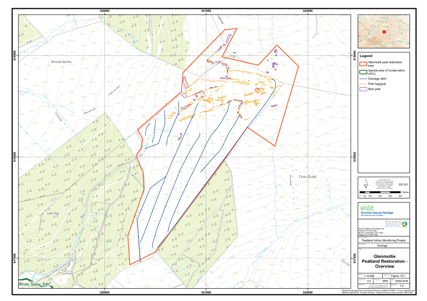
Figure 23. Overview of the peatland restoration conducted at Glenmullie
Click for a full description
The peatland restoration area at Glenmullie is delineated in red on an OS basemap.
Restoration features comprise:
- Drainage ditches, represented by blue lines;
- Peat haggs and gullies, represented by green lines;
- Bare peat, represented by unfilled purple polygons.
The boundary of the River Spey Special Area of Conservation is show as a green line.
Existing monitoring on site
Information received from NatureScot does not indicate whether there is any ongoing hydrological or vegetation monitoring of the site.
Restoration measures undertaken
Peatland restoration measures were implemented at Glenmullie during winter 2014/2015. No detailed restoration report was available, however a summary of the techniques intended for use was supplied by NatureScot. These were:
- Blocking drainage ditches (with peat dams and possibly some plastic or stone dams);
- Re-profiling the drainage ditches and filling some in;
- Re-profiling haggs and gullies;
- Re-vegetating haggs and gullies using a variety of techniques such as geo-textile, spot turfing, grass nurse crop, Sphagnum transplanting, and heather brash (with NPK fertiliser added);
- Re-vegetating bare peat using a variety of techniques as in 4 above; and
- Finally, the removal of conifer colonisation from the site.
The techniques used on site prior to the date of the survey differed from the summary list, and comprised the following:
- Re-profiling of the former peat cuttings, haggs and gullies and subsequent patching with turves;
- Blocking of drainage ditches with peat dams; and
- Covering of flat areas of bare peat and re-profiled haggs with mulch or heather brash harvested on the site.
Implementation of a geo-textile or a grass nurse crop, together with fertiliser, was not recorded. Conifers have occasionally been removed adjacent to the track, immature trees/saplings were frequent in the north-western part of the site. It was not possible to determine whether areas that were treated with mulch or heather brash had NPK fertiliser added.
Monitoring of the restoration measures took place on the 14th and 15th July 2015 by Helen Hamilton (Principal Ecologist, MCIEEM, CEnv) and Paul Fisher (Principal Ecologist, MCIEEM). The monitoring strategy implemented is discussed below.
Monitoring strategy
The sampling strategy was designed to monitor change in vegetation post treatment. Samples were taken across three treatment types. A further sample of the area mown to provide mulch for the bare peat areas was also taken to enable an assessment of the recovery of the cut vegetation over time. The sample areas were as follows:
- Area A - Re-profiled former peat cutting with mulch added (Post-treatment sample);
- Area B - Steep peat hagg with mulch added (Post-treatment sample);
- Area C - Flat expanse of bare peat with mulch added (Post-treatment sample);
- Area D - Grips in degraded blanket bog blocked with peat dams (Post-treatment sample);
- Area E - Grips in dry blanket bog blocked with peat dams (Post-treatment sample); and
- Area F - Area mown for mulch/heather brash (Post-treatment sample).
In each of the six sample plots 15 2m x 2m quadrats were collected across a homogenous stand of the main vegetation type within the treated area. Quadrats were sampled randomly within the homogeneous vegetation stand. The abundances of all plant species were recorded as percent cover. A number of environmental and vegetation community measurements were also taken, including cover of bare peat, vegetation height and presence of dung (see Annex I for further details).
Sampling of the treated areas was undertaken approximately nine months after management had been completed. The dataset gathered provides a first sample post-treatment for all treatments. The quadrat sample set (90 quadrats across Area A, B, C, D, E and F) allows for robust statistical analysis of change in the vegetation communities over time.
Fixed point photographs of each area were taken to supplement the 2m x 2m quadrat samples.
Baseline survey results
Table 11 presents a summary of the plant species recorded in each of the four sample areas along with their abundance (DAFOR scale). Quadrat data are presented in Annex II and their locations area shown on Figure 24. The fixed point photographs are presented within Annex III and their locations shown on Figure 25. Each sample area is described below.
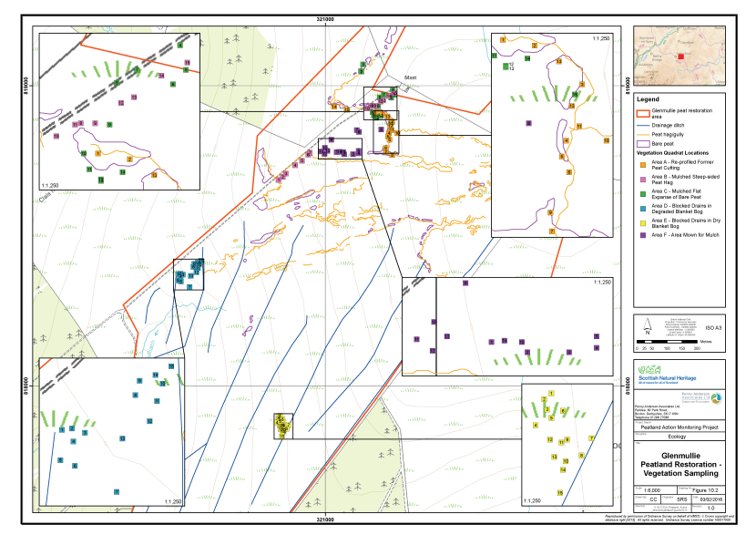
Figure 24. The vegetation survey quadrat locations at Glenmullie
Click for a full description
The peatland restoration area at Glenmullie is delineated in red on an OS basemap.
Restoration features comprise:
- Drainage ditches, represented by blue lines;
- Peat haggs and gullies, represented by green lines;
- Bare peat, represented by unfilled purple polygons.
The locations of the vegetation survey quadrats are shown as filled, numbered squares:
- Area A, in orange, reprofiled former peat cutting;
- Area B, in pink, mulched steep-sided peat hagg;
- Area C, in green, mulched flat expanse of bare peat;
- Area D, in blue, blocked drains in degraded blanket bog;
- Area E, in yellow, blocked drains in dry blanket bog;
- Area F, in purple, area mown for mulch.
There are five inset maps, which show zoomed in views of some of the clusters of the vegetation survey quadrats in relation to the peatland restoration features.
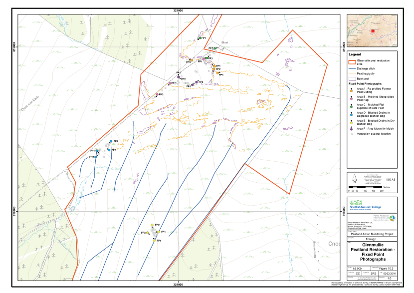
Figure 25. The locations of fixed point photography at Glenmullie
Click for a full description
The peatland restoration area at Glenmullie is delineated in red on an OS basemap.
Restoration features comprise:
- Drainage ditches, represented by blue lines;
- Peat haggs and gullies, represented by green lines;
- Bare peat, represented by unfilled purple polygons.
The locations of the fixed point photography are shown as filled, filled circles with an arrow indicating the direction that the photographer faced:
- Area A, in orange, reprofiled former peat cutting;
- Area B, in pink, mulched steep-sided peat hagg;
- Area C, in green, mulched flat expanse of bare peat;
- Area D, in blue, blocked drains in degraded blanket bog;
- Area E, in yellow, blocked drains in dry blanket bog;
- Area F, in purple, area mown for mulch.
The locations of the vegetation survey quadrats are shown as filled grey squares.
Table 11. Abundance of plants recorded in the sample plots, Glenmullie, 2015
|
Common Name |
Scientific Name |
Area A |
Area B |
Area C |
Area D |
Area E |
Area F |
|---|---|---|---|---|---|---|---|
|
Bilberry |
Vaccinium myrtillus |
- |
- |
- |
R |
O |
O |
|
Common cottongrass |
Eriophorum angustifolium |
- |
- |
O |
O |
- |
O |
|
Cowberry |
Vaccinium vitis-idaea |
- |
- |
- |
R |
- |
- |
|
Cross-leaved heath |
Erica tetralix |
- |
- |
- |
R |
- |
R |
|
Crowberry |
Empetrum nigrum |
O |
- |
R |
R |
R |
R |
|
Downy birch |
Betula pubescens |
- |
R |
- |
- |
- |
- |
|
Hare's-tail cottongrass |
Eriophorum vaginatum |
F |
R |
R - O |
A - D |
D |
- |
|
Heath rush |
Juncus squarrosus |
- |
R |
R |
O - LF |
- |
F |
|
Heather |
Calluna vulgaris |
F - A |
R |
R |
A - D |
A |
LF |
|
Rowan |
Sorbus aucuparia |
- |
- |
- |
- |
- |
R |
|
Sitka spruce |
Picea sitchensis |
- |
R |
- |
O |
R |
- |
|
Wavy hair-grass |
Deschampsia flexuosa |
- |
R |
- |
- |
F |
- |
|
A moss |
Aulacomnium palustre |
- |
R |
- |
- |
R |
- |
|
A moss |
Campylopus sp. |
- |
R |
R |
- |
- |
- |
|
A lichen |
Cladonia sp. |
O |
R |
- |
F - A |
- |
R |
|
A moss |
Dicranella heteromalla |
- |
R |
- |
- |
- |
- |
|
A moss |
Dicranum scoparium |
- |
R |
R |
- |
R |
- |
|
A moss |
Hylocomium splendens |
R - O |
- |
- |
F - A |
F |
R |
|
A moss |
Hypnum jutlandicum |
- |
R |
- |
A - D |
- |
- |
|
A moss |
Plagiothecium undulatum |
- |
R |
- |
- |
- |
- |
|
A moss |
Pleurozium schreberi |
F |
R |
- |
A |
D |
O - F |
|
A moss |
Polytrichum commune |
- |
R |
R |
F - A |
O |
O - F |
|
A moss |
Polytrichum juniperinum |
- |
- |
R |
- |
- |
- |
|
A moss |
Pseudoscleropodium purum |
- |
- |
R |
- |
- |
- |
|
A bog moss |
Sphagnum capillifolium sensu lato |
- |
R |
- |
F |
R |
R |
|
A bog moss |
Sphagnum cuspidatum |
- |
- |
- |
R - O |
R-O |
- |
|
A bog moss |
Sphagnum fallax |
- |
R |
R |
F - A |
- |
- |
|
A bog moss |
Sphagnum papillosum |
R |
- |
- |
- |
- |
R |
Area A - Re-profiled former peat cutting
This sample plot comprised an approximately 350m long peat cutting situated on either side of the transmitter access road. The majority of the cutting faces south although the far eastern end of the cutting faces west. Vegetation on the higher ground to the north and east of the cutting comprised M19 blanket bog dominated by hare’s-tail cottongrass with abundant heather together with cloudberry and Sphagnum capillifolium subsp. rubellum. The blanket bog area was moderately gullied, with the gullies following the west-facing slope of the hill summit. The cutaway area at the base cutting was heather-dominated with a carpet of Sphagnum capillifolium sensu lato.
The cutting had been re-profiled to around 30° prior to the survey and partially re-vegetated using turf won during the process, together with some stripped from the adjacent blanket bog. The remaining bare areas had been covered with mulch harvested from the base of the peat cutting. Vegetation on the restored face of the cutting comprised heather, hare’s-tail cottongrass, crowberry and the moss Pleurozium schreberi. Patches of bare peat were present along the cutting, where the mulch had been weathered away since it was applied.
Area B - Mulched steep sided peat hagg
This sample plot comprised two lengths of a steep hagged bank of peat, lying to the east of the transmitter access track. The bank had a slope of between 30° and 50° and the bank top was approximately 2.5m - 3.0m above the road. The two lengths of hagg sampled were separated by a flat area with no bank, where the peat had been cut away. Established vegetation comprising heather, hare’s-tail cottongrass and spruce saplings occurred in patches interspersed with bare peat. Adjacent vegetation comprised M19 blanket bog as in Area A.
The bare peat between the established vegetation patches had been treated with mulch and heather brash prior to the survey. The purpose of the mulch and brash was to act as a source of propagules to speed the process of natural colonisation of the bare peat. Detailed sampling was undertaken on the treated bare peat, avoiding the islands of more established vegetation as much as possible.
Vegetation within the treated areas was sparse and comprised 7% cover on average. The most frequently recorded species were heather, hare’s-tail cottongrass, crowberry and crustose Cladonia lichen, together with the mosses Pleurozium schreberi and Polytrichum commune. Numerous spruce saplings and seedlings were recorded across the area, outside the quadrats.
Area C - Mulched flat expanse of bare peat
This sample plot comprised several flat areas (between 0° and 10° slope). These included the base of the peat cutting sampled by Area A and additional bare patches close to the transmitter station. Established vegetation within these patches comprised occasional heather bushes and tussocks of hare’s-tail cottongrass. Adjacent vegetation comprised M19 blanket bog as in Area A.
The bare peat had been treated with mulch and heather brash prior to the survey. The purpose of the mulch and brash was to act as a source of propagules to speed up the process of natural colonisation of the bare peat. Detailed sampling was undertaken on treated bare peat, avoiding the occasional islands of more established vegetation as much as possible.
Vegetation within the treated areas was sparse and comprised 14% cover on average. The most frequently recorded species included heather, hare’s-tail cottongrass, crowberry and crustose Cladonia lichen together with the mosses Pleurozium schreberi and Polytrichum commune. Some rooting of bryophytes introduced with the mulch had occurred, including a Sphagnum species and the moss Pseudoscleropodium purum. Numerous spruce saplings and seedlings were recorded across the area outside the quadrats.
Area D - Blocked drains in degraded blanket bog
This sample plot was located at the north-western edge of the drained part of the restoration site. The drains had been blocked with peat dams placed at approximately 10m spacing. The aim of this treatment was to prevent water flow within the drains and promote pooling behind the dams, to provide a stable environment for aquatic Sphagnum moss species to colonise, and raise the water table within the adjacent peat.
The vegetation of the sample area was referable to M19 bog, but was generally dominated by heather, together with cross-leaved heath, common cottongrass, heath-rush, the lichen Cladonia portentosa and the moss Pleurozium schreberi. Hare’s-tail cottongrass was present in the majority of quadrats but, where heather was dominant, it was reduced to low cover or was absent altogether. The bog moss Sphagnum capillifolium subsp. rubellum was frequent beneath the heather canopy.
Area E - Blocked drains in dry blanket bog
This sample plot was located within the north-eastern part of the drained area of the restoration site. The drains had been blocked with peat dams spaced approximately 10m apart. The aim of this treatment was to prevent water flow within the drains and promote pooling behind the dams, to provide a stable environment for aquatic Sphagnum moss species to colonise, and raise the water table within the adjacent peat.
In contrast to Area D, hare’s-tail cottongrass was constant here, together with heather and wavy hair-grass; the latter species suggesting significant drying of the peat. Sphagnum species were occasional and attained only modest cover. No individual Sphagnum species were recorded in more than two quadrats which, together with the abundance of hare’s-tail cottongrass, suggested that the vegetation had greater affinity to M20 Hare’s-tail cottongrass bog, than M19 bog. Pleurocarpous mosses were more abundant here than in Area D, with Pleurozium schreberi and Hylocomium splendens constant and attaining high levels of cover in some quadrats.
Area F - Area mown for mulch
This sample plot was located in the base of the main peat cutting, where the mulch used on the bare peat areas had been harvested. This area was sampled to provide a means of monitoring the recovery of the area following mowing.
The vegetation was dominated by heath rush with heather also constant, but attaining low cover values. Other abundant species included the mosses Polytrichum commune and Pleurozium schreberi. Six Sphagnum species were recorded here although the majority were recorded in two or fewer quadrats and at low cover values. Sphagnum capillifolium subsp. rubellum was the most abundant; occasional overall but attained up to 35% cover in places.
Constraints on survey
There were no significant constraints noted for the survey. The site was accessed via the forest road leading to the Breac Leathad transmitter. Parking was available adjacent to the site. A four-wheel drive vehicle was used, although access might be possible in a two-wheel drive vehicle as the forest roads are in generally good condition. A good level of ground clearance is, however, considered essential.
Assessment of restoration approach
Future monitoring datasets will enable post-treatment change to be assessed over time in the vegetation of the six sample areas.
Long-term success of the mulch/brash treatment (Areas A, B and C) was considered uncertain. As observed at Edinglassie (Section 2) and Glen Ey (Section 3) the mulch layer had been broken up and dispersed by the weather and hydrological processes since application (see Annex III), leaving some areas with significant accumulations of material and others with very little. Regeneration of vegetation fragments and heather seed applied with the mulch was found to be sparse and vegetation re-growth that could be attributed directly to the treatment mainly comprised pleurocarpous mosses.
The restoration approach adopted for the drains in the southern part of the site (Areas D and E) was considered to be likely to show a positive effect in the long-term. The drains are generally more than 100m apart, however, and it is considered that increases in the water table level within the peat may only be detectable in the vegetation in close proximity to the drains. Peat depth is relatively shallow across the southern part of the site, being generally less than 1.0m. It is likely that, together with the slope of the site, this may be a limiting factor on the quality of the vegetation that might be achievable in the long-term.
The peat dams were generally functioning well and had successfully reduced flow in the drains. Although the dams had slowed water flow, it is worth noting that few dams were retaining water to the level of the top of the drain. This effect was particularly notable in the eastern part of the site, where peat dams had been placed directly onto less than 0.2m of peat or mineral ground. This had likely resulted in under-cutting of the dams and these may eventually wash-out. Water flow over and around a number of dams was also observed and had led to erosion alongside the dam in some cases. This process may also lead to eventual wash-out. The survey was carried out too soon after damming for colonisation of the pools behind the dams by Sphagnum moss to be recorded.
It is recommended that condition of the peat dams is monitored in 2016 and remedial action taken to prevent washing-out if necessary. A walkover inspection of the mulched areas should also be carried out. If there has been little colonisation from the mulch by 2016, it is likely that the bare peat environment has been too unstable for plants to become established. Assessment of water flow patterns across the flatter bare peat areas might show that continual wash-out has prevented moss fragments and heather seedlings from becoming established. If this were the case, heather bales or coir roles are recommended to subdivide large expanses of bare peat and break up water flow to stabilise the peat surface for vegetation colonisation. Plug planting of common cottongrass plants should be considered for any flat bare peat stabilised in this way. Reassessment of the steeper mulched areas is also recommended. If these have been unsuccessful, use of geojute to stabilise the steeper areas should be considered, together application of heather brash.
A re-survey of the site in 2017 would be a suitable timeframe for monitoring, along with the on-going interim monitoring of dam integrity and the mulching treatment suggested above.
Luss Estate
Overview of the site
The Luss Estate restoration site consists of four separate areas comprising approximately 400ha. The four restoration areas are situated either side of Glen Finlas, north-east of Helensburgh, Argyll and Bute. Due to the relative inaccessibility of Areas 3 and 4 (Beinn Ruisg and Creachan Hill, respectively), and because Areas 2, 3 and 4 would receive essentially the same treatments, monitoring was focused on Areas 1 and 2 of the restoration site, on the western side of Glen Finlas. None of the restoration areas are subject to any statutory designations.
The monitoring site is located on the south-east ridge of Balcnock between 540m and 350m elevation and comprises two separate areas (Figure 26). The first area is located around the summit of Balcnock while the second area includes the plateau below Craperoch. Both sites are located on the watershed of the hill and drain westwards to Fruin Water and eastwards to Finlas Water, both of which feed into Loch Lomond. The primary land use on both sites is sheep grazing.
The monitoring site includes extensive areas of hagged peat, as well as moor grips which feed into the natural drainage systems on both sides of the hill. Vegetation of the hagged areas comprises degraded blanket bog with abundant heath rush and wavy hair-grass and few Sphagnum species. Blanket bog vegetation within the gripped area is richer and includes some Sphagnum moss, but frequent heath rush, wavy hair-grass, tormentil and Rhytidiadelphus squarrosus indicate an overall degraded state. The degradation indicators are consistent with long-term heavy grazing together with drying of the peat through drainage and erosion. It is also likely that fire has had a prominent role in shaping the vegetation and peatland found on the site.
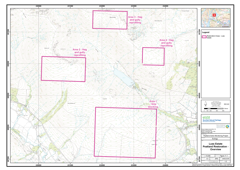
Figure 26. Potential peatland restoration areas at Luss Estate
Click for a full description
Four rectangles indicating potential restoration areas on Luss Estate are shown on an OS basemap.
- Area 1, grip blocking
- Area 2, hagg and gully reprofiling
- Area 3, hagg and gully reprofiling
- Area 4, hagg and gully reprofiling.
Existing monitoring on site
Information received from NatureScot does not indicate whether there is any ongoing hydrological or vegetation monitoring of the site.
Restoration measures undertaken
The main aim of the restoration project is to restore the hydrological integrity of the blanket peat and stabilise eroding peat to promote carbon sequestration and slow the wash out of organic carbon from the peatland system. No restoration measures had been implemented at the time of the survey and therefore the dataset collected represents a pre-treatment baseline.
Detailed information on the restoration project was supplied by NatureScot in the form of the Peatland Action grant application. This document outlined the treatments that would be put in place in each of the four separate areas and provided some background on the management of the estate. Detailed mapping of the locations of the treatments was not available, although some detail was provided in the application form. The restoration measures proposed are:
- Re-profiling and turfing of peat haggs;
- Gully/grip blocking with peat, stone and timber;
- Restoration of bare peat ‘pans’ using timber and peat dams or turf bunds;
- Re-vegetation using locally harvested heather brash and Sphagnum; and
- Total infilling of grips with peat.
Pre-treatment monitoring took place on 7th October 2015 by Helen Hamilton (Principal Ecologist, MCIEEM, CEnv) and Paul Fisher (Principal Ecologist, MCIEEM). The monitoring strategy implemented is discussed below.
Monitoring strategy
The strategy was designed to monitor the change in vegetation post treatment. A total of three samples were taken, each allocated an Area code (A, B and C). Samples of the two main treatments for restoration areas 1 and 2 (hagg re-profiling and grip infilling) were taken, together with a relatively unmodified reference area. The sample plots are outlined below:
- Area A - Peat hagg re-profiling (Pre-treatment baseline);
- Area B - Grip infilling I (Pre-treatment baseline); and
- Area C - Grip infilling II (Reference).
In each of Areas A, B and C, a total of 15 2m x 2m quadrats were collected across a homogenous stand of the main vegetation type within the treated area. Quadrats were sampled randomly within the homogeneous vegetation stand. The abundances of all plant species were recorded as percent cover. A number of environmental and vegetation community measurements were also taken, including cover of bare peat, vegetation height and presence of dung (see Annex I for further details).
The quadrat survey targeted several aspects of the restoration approaches, which varied by Area. In Area A bare peat on the eroding faces of the haggs was targeted to provide a baseline against which success of the re-profiling treatment could be assessed in the future. In Area B and C the survey targeted the vegetation between the grips, to provide an appropriate dataset to quantify change over time in response to any re-wetting that may occur as a result of the treatment. The quadrat sample set (45 quadrats across Areas A, B and C) allows for robust statistical analysis of change in the vegetation communities over time.
Fixed point photographs of each area were taken to supplement the 2m x 2m quadrat samples.
Baseline survey results
Table 12 presents a summary of the plant species recorded in each of the three sample areas along with their abundance (DAFOR scale). Quadrat data are presented in Annex II and their locations shown in Figure 27. The fixed point photographs are presented within Annex III and their locations shown on Figure 28. Each sample area is described below.
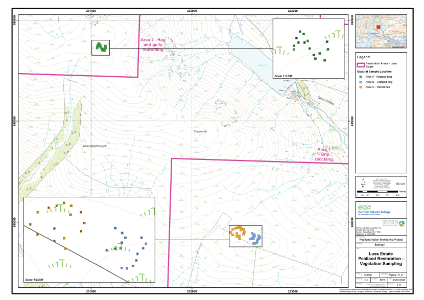
Figure 27. The vegetation survey quadrat locations at Luss Estate
Click for a full description
A portion of Luss Estate is shown on an OS basemap.
The locations of the vegetation survey quadrats are shown as filled squares:
- Area A, in green, hagged bog;
- Area B, in blue, gripped bog;
- Area C, in orange, reference area.
There are two inset maps, which show zoomed in views of the clusters of the vegetation survey quadrats showing their number.
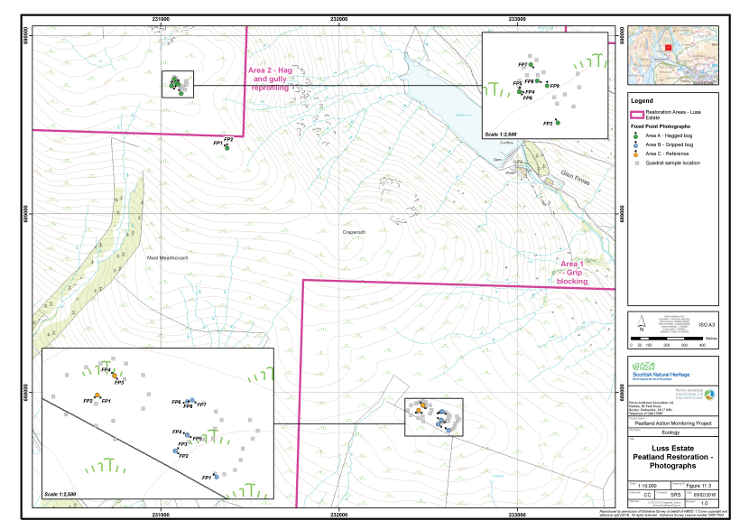
Figure 28. The locations of fixed point photography at Luss Estate
Click for a full description
A portion of Luss Estate is shown on an OS basemap.
The locations of the fixed point photography are shown as filled circles with an arrow indicating the direction the photographer faced:
- Area A, in green, hagged bog;
- Area B, in blue, gripped bog;
- Area C, in orange, reference area.
There are two inset maps, which show zoomed in views of the clusters of the vegetation survey quadrats showing their number.
The locations of the vegetation survey quadrats are shown as filled grey squares.
Table 12. Abundance of plants recorded in the sample plots, Luss Estate, 2015
|
Common Name |
Scientific Name |
Area A |
Area B |
Area C |
|---|---|---|---|---|
|
Sweet vernal-grass |
Anthoxanthum odoratum |
- |
O |
- |
|
Heather |
Calluna vulgaris |
O-A |
F-A |
A-D |
|
Wavy hair-grass |
Deschampsia flexuosa |
F |
F |
F |
|
Crowberry |
Empetrum nigrum |
O |
- |
- |
|
Cross-leaved heath |
Erica tetralix |
- |
R |
F |
|
Common cottongrass |
Eriophorum angustifolium |
O |
- |
O |
|
Hare's-tail cottongrass |
Eriophorum vaginatum |
A |
A-D |
A |
|
Heath bedstraw |
Galium saxatile |
- |
F |
- |
|
Heath rush |
Juncus squarrosus |
A-D |
F |
- |
|
Mat-grass |
Nardus stricta |
F-LD |
- |
- |
|
Bog asphodel |
Narthecium ossifragum |
- |
A |
F-A |
|
Tormentil |
Potentilla erecta |
- |
D-F |
O |
|
A bog moss |
Trichophorum germanicum |
A |
O-LA |
F-A |
|
Bilberry |
Vaccinium myrtillus |
F-A |
F |
F |
|
Cranberry |
Vaccinium oxycoccos |
- |
- |
R |
|
Cowberry |
Vaccinium vitis-idaea |
R |
- |
- |
|
A moss |
Aulacomnium palustre |
- |
O |
- |
|
A moss |
Hylocomium splendens |
- |
O-F |
- |
|
A moss |
Hypnum jutlandicum |
A |
O |
F |
|
A moss |
Pleurozium schreberi |
A |
A |
- |
|
A moss |
Polytrichum commune |
- |
F |
O |
|
A moss |
Polytrichum juniperinum |
- |
O |
- |
|
A moss |
Rhytidiadelphus loreus |
- |
O |
- |
|
A moss |
Rhytidiadelphus squarrosus |
- |
LF |
- |
|
A bog moss |
Sphagnum capillifolium |
F |
O-F |
A |
|
A bog moss |
Sphagnum fallax |
- |
R-O |
O |
|
A bog moss |
Sphagnum palustre |
- |
|
O |
|
A bog moss |
Sphagnum papillosum |
- |
R-O |
A |
|
A bog moss |
Sphagnum subnitens |
- |
O |
- |
Area A - Peat hagg re-profiling
This sample plot comprises a group of eroding peat haggs on a south facing slope, below the summit of Balcnock. Erosion of the peat mantle on this part of the hill has been very severe, leaving a rash series of haggs which is consistent with the effects of severe fires. The haggs are between 1.5m-2.0m high and stand proud of a matrix of bog-grassland on shallow peat, up to 0.5m deep. The matrix peat has eroded completely at the bases of a number of the haggs, exposing the underlying mineral material. Sheep droppings were abundant across the area, indicating ongoing heavy grazing.
The matrix vegetation comprised abundant heath rush and hare’s-tail cottongrass, with a range of associates typical of both blanket bog on the one hand and dry heath/acid grassland on the other. These included common cottongrass, deergrass, bilberry, heather, cowberry, crowberry, wavy hair-grass, mat grass and the mosses Pleuzoium schreberi and Hypnum jutlandicum. The bare eroding faces of the haggs supported sparse common cottongrass, hare’s-tail cottongrass, bilberry, crowberry and wavy hair-grass.
Area B - Grip infilling I
This sample plot is located on a small relatively flat area south-east of Craperoch. The small plateau, together with the slopes above and the eastern flank of the hillside below, has been extensively drained with moor grips. In Area B, the dimensions of the grips are approximately 0.5m x 0.5m, and 1.0m on the slopes just outside the sample plot. The shallower grips were hydrologically active, but partially vegetated with Sphagnum fallax and S. palustre.
Vegetation between the grips comprised M20 blanket bog dominated by hare’s-tail cottongrass and heather, with abundant Polytrichum commune and Pleurozium schreberi and frequent bilberry and deergrass. Sphagnum capillifolium subsp. rubellum was frequent, but S. papillosum was sparse. It is likely the current vegetation was derived from M17 blanket bog by heavy grazing and burning. Abundant dung and grazing on dwarf shrubs suggested that heavy grazing pressure was ongoing.
Area C - Grip infilling II
This sample plot is located to the north-west of the large gully which defines the north-western edge of Area B. The grips in Area C are of similar dimensions as those in Area B, but are filled to a greater depth with vegetation including common cottongrass, Sphagnum fallax and S. palustre. The vegetation of the area was considered to be of higher quality than Area B, possibly due to greater peat depth or the lighter gripping within this area.
Vegetation between the grips comprised blanket bog referable to M17, with co-dominant hare’s-tail cottongrass, deergrass, heather, cross leaved-heath and bog asphodel. Sphagnum capillifolium sensu lato and S. papillosum were abundant. Indicators of drying such as wavy hair-grass and tormentil were present, but obligate bog species were more abundant than in Area B.
Constraints on survey
No significant constraints on survey or access were noted.
Access was gained from a large lay-by on the A817 Haul Road, at grid reference NS 3318 8665. Surveyors followed a GPS bearing toward the local summit at NS 3263 8775 at the edge of the site. The walk onto site took approximately ½ hour, up over rough cattle pasture and stands of rushes.
Assessment of restoration approach
Future monitoring datasets will enable post-treatment change in the vegetation on the re-profiled peat (Area A) and between the infilled grips (Areas B and C) to be assessed in detail. The 2015 dataset will form a valuable pre-treatment baseline against which future post-treatment datasets for this area can be compared. It was not possible to find a suitable reference site for comparison in future years as all areas had been subject to degradation either through hagging or drainage.
The re-profiling treatment scheduled for Area A has been used with at least short-term success (and projected long-term success) on several other sites surveyed as part of ‘Monitoring the Success of Peatland Action’ (e.g. Edinglassie and Glen Ey) and on other restoration sites around the UK. However, many of the sites where it has been used successfully have had relatively low grazing pressure and an abundance of heather, which can thrive in the better drained conditions prevalent on re-profiled hagg slopes.
Detailed information on grazing pressure within the restoration site was not available for consideration as part of the monitoring study. However, anecdotal evidence collected during the survey suggests that sheep numbers are probably quite high. Indicators of heavy grazing recorded included abundant sheep dung across the site and low cover of dwarf shrubs, even on drying peat haggs, where they would be expected to be abundant.
High grazing pressure has the potential to limit the success of turf translocation. The greatest risk is through trampling which exposes the edges of the turves to weathering and can cause slippage and subsequent erosion. Given that the site is very exposed to the prevailing westerly wind, it is recommended that the re-profiled and turfed hagg faces are closely monitored post-treatment. Remedial action in the event of damage to turves by stock may include a reduction in stock numbers and the re-treatment of any damaged areas. It is also recommended that the bare peat re-vegetation treatments that rely on seed application (e.g. application of heather brash) are closely monitored as these are even more susceptible to stock damage than turf translocation.
The outline specification provided by NatureScot for the restoration work at the Luss site suggests that infilling of grips will be carried out over 200ha of the site, where the gradient of the grips is more than 8°. As no other source of peat is available (e.g. spoil mounds adjacent to recently excavated ditches), the specification notes that infill material will have to be won from the bog adjacent to the grip. Infilling of grips requires a greater volume of peat than the capacity of the ditch and it is therefore recommended that this treatment is undertaken with extreme caution due to the potential damage that may be caused to the adjacent intact peat.
A less risky solution than infilling would be use another method of dam construction (e.g. plastic or timber) which incorporates a spillway to allow excess water to escape down the channel and mitigates against the build up of a head of pressure which could cause a breach. On steeper slopes, dams should be more closely spaced and incorporate a splash plate (e.g. a heather bale) to absorb the energy of water issuing from the spillway of the dam above and thus prevent scour downstream.
The outline specification for the restoration work suggests that elsewhere the main dam construction material would be peat. This has been used with success on several other sites surveyed as part of this project; for example Drumrunie and Flanders Moss. This method has also been successfully employed on many other restoration sites in the UK.
A re-survey of the site in 2018 would be a suitable timeframe for monitoring, along with more regular on-going liaison with the contractors.
Barlosh Moss
Overview of the site
Barlosh Moss comprises 13ha of lowland raised bog (Figure 29). The site is approximately 3km south west of Ochiltree in Ayrshire. The raised bog feature forms the eastern part of Barlosh Moss SSSI, which also includes a vegetated lochan (Plaid Loch) with a complex of wetlands including swamp, poor fen, marshy grassland and wet woodland (SNH 2008a). The raised bog is separated from the other wetlands by a track and drain running north to south.
Information received on Barlosh Moss (SNH 2008b) states that in the 1970s, and in the early 1980s, water flow to Plaid Loch was re-routed and an extensive drainage network was developed within and surrounding part of the site. These features are still in evidence in 2015; accessing the site from Rottenrow, to the north, requires a substantial encircling drain to be crossed. The drainage features are considered to have reduced the water table within the peat to the extent that conditions became favourable for the encroachment of trees. In addition, the far eastern edge of the bog was further drained and planted with Scots pine.
In 2002, NatureScot set up a five-year Management Agreement in order to address the issues associated with the eastern part of Barlosh Moss SSSI. Part of this agreement included the clear felling of all the trees present. In addition, a drain running along the southern boundary of the raised bog was intercepted outside of the site’s boundary causing it to become less active.
Before the tree felling work, funded by peatland action, took place in winter 2014/2015, the raised bog had become wooded with mature and young Scots pine and birch. Bog vegetation survived amongst the trees in many areas, particularly in the west and north-western parts of the site although it had almost disappeared from the older stands of mature trees to the east.
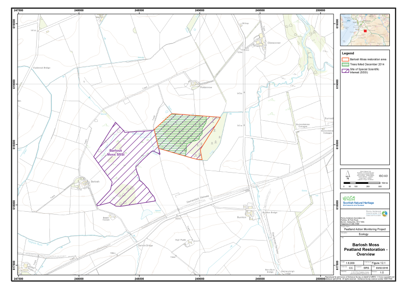
Figure 29. Overview of Barlosh Moss SSSI, including the peatland restoration area
Click for a full description
Barlosh Moss SSSI is delineated by a purple hashed line on an OS basemap. The area of peatland restoration is delineated in red. Within the peatland restoration area, green, horizontally hashed lines indicate the area where trees were felled in December 2015.
Existing monitoring on site
No fixed vegetation monitoring plots or hydrological monitoring equipment appeared to have been installed on the site prior to the survey in 2015. As the site is an SSSI, it has been subjected to periodic Condition Assessment by NatureScot. The last assessment in 2013 showed that the raised bog feature was in unfavourable-declining condition due to tree cover.
Restoration measures undertaken
Restoration under the Peatland Action programme took place between November 2014 and February 2015. This involved the removal of mature trees, saplings and seedlings over approximately 10ha of the site. The felled material (chips and other timber) were largely removed from the site, although some occasional brash was left behind, particularly in the eastern part of the site, which was previously more mature woodland.
Upon the completion of the restoration works a five year management plan is scheduled to be implemented. No details of this were available, but it is expected to include a grazing management regime using cattle and sheep.
Monitoring of the restoration measures was carried out between 26th and 27th August 2015 by Alistair Blackshaw and Helen Hamilton.
Monitoring strategy
The strategy was designed to monitor change in vegetation post treatment. A total of three samples were taken, each allocated an Area code (A, B and C respectively). Two of the Areas had been treated and a third area comprised a reference site. The Areas are outlined below:
- Area A - Relatively unmodified blanket bog (Reference);
- Area B - Felled young self-seeded woodland (Post-treatment sample); and
- Area C - Felled semi-mature self-seeded woodland (Post-treatment sample).
In each of the four sample areas, a total of 20 2m x 2m quadrats were collected across the main vegetation. Quadrat sampling targeted homogeneous areas of vegetation, typical of the feature. Quadrats were sampled randomly within the homogeneous vegetation stand. The abundances of all plant species were recorded as percent cover. A number of environmental and vegetation community measurements were also taken, including cover of bare peat, vegetation height and presence of dung (see Annex I for further details).
Sampling was undertaken five months after the treatment had been applied, therefore providing a good post-treatment baseline for future monitoring of change in the vegetation of Areas B and C. The reference site (Area A) will enable an assessment of how similar the vegetation communities of the treated areas are to relatively unmodified bog in future years. The quadrat sample set (60 quadrats across Area A, B and C) allows for robust statistical analysis of change in the vegetation communities change over time.
Fixed point photographs of each area were taken to supplement the 2m x 2m quadrat samples.
Baseline survey results
Table 13 presents a summary of the plant species recorded in each of the four sample areas along with their abundance (DAFOR scale). Quadrat data are presented in Annex II and their locations are shown on Figure 30. The fixed point photographs are presented within Annex III and their locations shown on Figure 31. Each sample area is described below.
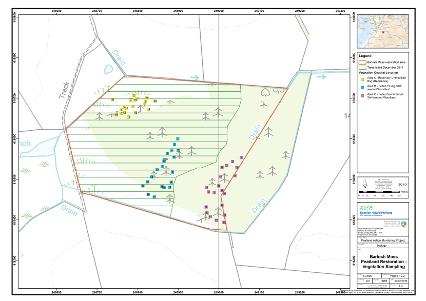
Figure 30. The vegetation survey quadrat locations at Barlosh Moss
Click for a full description
The peatland restoration area of the Barlosh Moss SSSI is delineated in red on an OS basemap.
Green horizontally hashed lines represent the area where trees were felled in December 2015.
Three clusters of vegetation survey quadrats are shown as filled, numbered squares:
- Area A, in yellow, relatively unmodified bog (reference);
- Area B, in blue, felled young, self-seeded woodland;
- Area C, felled semi-mature, self-seeded woodland.
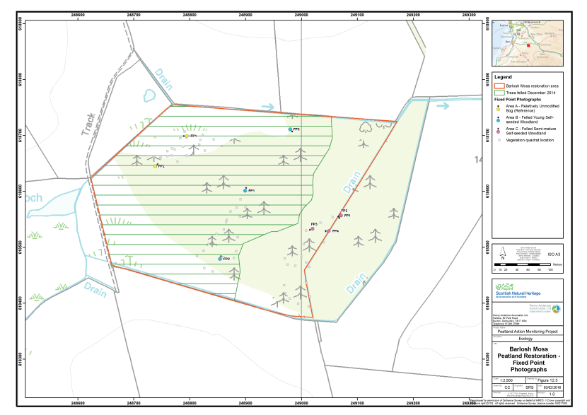
Figure 31. The locations of fixed point photography at Barlosh Moss
Click for a full description
The peatland restoration area of the Barlosh Moss SSSI is delineated in red on an OS basemap.
Green horizontally hashed lines represent the area where trees were felled in December 2015.
Three clusters of fixed point photography are shown as filled, numbered circles with an arrow indicating the direction the photographer faced:
- Area A, in yellow, relatively unmodified bog (reference);
- Area B, in blue, felled young, self-seeded woodland;
- Area C, felled semi-mature, self-seeded woodland.
Table 13. Abundance of plants recorded in the sample plots, Barlosh Moss, 2015
|
Common name |
Scientific name |
Area A |
Area B |
Area C |
|---|---|---|---|---|
|
Brash/stumps |
- |
- |
F |
F - A |
|
Bog asphodel |
Narthecium ossifragum |
R |
- |
- |
|
Broad buckler-fern |
Dryopteris dilatata |
- |
- |
A |
|
Common cottongrass |
Eriophorum angustifolium |
F |
- |
- |
|
Cranberry |
Vaccinium oxycoccos |
F |
O |
- |
|
Cross-leaved heath |
Erica tetralix |
F |
F |
O |
|
Downy birch |
Betula pubescens |
F |
F |
F - A |
|
Hare's-tail cottongrass |
Eriophorum vaginatum |
A |
A |
F |
|
Heather |
Calluna vulgaris |
A |
A |
O |
|
Purple moor-grass |
Molinia caerulea |
- |
O |
- |
|
Raspberry |
Rubus idaeus |
- |
- |
O |
|
Rosebay willowherb |
Chamerion angustifolium |
- |
- |
F |
|
Round-leaved sundew |
Drosera rotundifolia |
O |
- |
- |
|
Scots pine |
Pinus sylvestris (seedling) |
R |
- |
- |
|
Sweet vernal-grass |
Anthoxanthum odoratum |
- |
- |
O |
|
Wood sorrel |
Oxalis acetosella |
- |
- |
O |
|
A moss |
Aulacomnium palustre |
O |
A |
- |
|
A moss |
Hypnum jutlandicum |
F |
F |
F |
|
A moss |
Kindbergia praelonga |
- |
- |
F |
|
A moss |
Pleurozium schreberi |
O |
F |
- |
|
A moss |
Polytrichum strictum |
O |
R |
- |
|
A moss |
Rhytidiadelphus squarrosus |
- |
- |
A |
|
A bog moss |
Sphagnum capillifolium subsp rubellum |
A |
A |
- |
|
A bog moss |
Sphagnum fallax |
R |
O |
- |
|
A bog moss |
Sphagnum magellanicum |
A |
F |
- |
|
A bog moss |
Sphagnum papillosum |
O |
- |
- |
|
A bog moss |
Sphagnum tenellum |
O |
- |
- |
|
A lichen |
Cladonia portentosa |
O |
O |
- |
Area A - Reference
This sample plot lies at the north-western edge of Barlosh Moss. The vegetation showed strong affinities to typical M18 blanket bog, with constant hare’s-tail cottongrass, heather, cross-leaved heath and Sphagnum capillifolium subsp. rubellum. Sphagnum magellanicum was also frequent, attaining up to 65% cover in lower lying hollows. Additional frequent species included cranberry, round-leaved sundew and the mosses Pleurozium schreberi, Aulacomnium palustre and Polytrichum strictum. Downy birch (Betula pubescens) seedlings and saplings were recorded in every quadrat at low cover values.
The sample plot was identified from online aerial photography as having the least dense tree cover, in comparison to other parts of the site, prior to the recent clearance works. Some vehicle tracks and a small amount of chippings were present in the area, but were avoided in sampling. Some clearance of birch had taken place here previously, but downy birch saplings and seedlings were frequent throughout. Despite the high frequency of young birch, Area A was considered to be representative of the least modified blanket bog vegetation on the site. It was therefore chosen as a reference against which the vegetation of the treated areas could be compared in future monitoring.
Area B - Felled young self-seeded woodland
This sample plot lies in the eastern part of Barlosh Moss. The vegetation was referable to M18 bog with hare’s-tail cottongrass, heather, cross-leaved heath and Sphagnum capillifolium subsp. rubellum constant. Notable differences between the vegetation this area and Area A were less frequent and less abundant Sphagnum magellanicum and a slight reduction in the frequency of pleurocarpous mosses and Polytrichum strictum. The major difference in Area B was the presence of brash and cut tree stumps in most quadrats and localised patches of damaged vegetation/bare ground caused by the recent felling operations.
The sample plot was identified from aerial photography, taken prior to the recent clearance works, as having moderately dense tree cover in comparison to other parts of the site. The cut stumps suggested that, prior to clearance, Scots pine was relatively frequent, but generally less mature than in Area C. Felling operations prior to the survey had removed all of the mature and semi-mature trees, although some small downy birch saplings and seedlings remained, comprising a similar level of frequency and cover as recorded in Area A. A great deal more labour would have been required to remove this residual cover of birch because of its small diameter and high frequency across the site.
Area C - Felled mature self-seeded woodland
This sample area lies at the eastern edge of Barlosh Moss. The vegetation was referable woodland ground-flora/open weedy communities, with a few blanket bog/heath species also present. The most constant species was broad-buckler fern, which is indicative of established woodland, joined by wood sorrel, often at high cover values, in approximately 75% of quadrats. Other frequent species suggestive of disturbed woodland included Yorkshire-fog (Holcus lanatus), rosebay willowherb and the moss Kindbergia praelonga. Downy birch seedlings or saplings were recorded in every quadrat, occasionally attaining more than 20% cover. The cover of brash from the felling operations and the remaining tree stumps was higher than in Area C comprising 10% - 45% cover in most quadrats.
The sample area was identified from aerial photography, taken prior to the recent clearance works, as having dense tree cover in comparison to other parts of the site. The photography together with the remaining cut stumps suggested Scots pine was frequent here and there were some quite mature trees. A substantial amount of brash also remains and, as with Area B, downy birch seedlings and saplings were frequent.
Constraints on survey
No significant constraints on survey or access were noted. It was possible to park, with the farmer’s permission, adjacent to a barn at Rotten Row, one field to the north of Barlosh Moss. The site was accessed on foot from there.
Assessment of restoration approach
The main treatment at Barlosh Moss has been to fell trees and established woodland and remove as much of the timber and brash from the site as possible. Future monitoring datasets will enable post-treatment change in the vegetation of two different felled areas to be monitored in detail: Area B will allow assessment of change after clearance of light woodland and Area C will allow assessment of change after clearance of dense established woodland. It will be possible to compare the treated areas with a reference site (Area A). This will enable an assessment of any subsequent shifts in the vegetation communities towards relatively unmodified bog.
Given the volume of timber felled, there was surprisingly little cut material left on the site. Removal of the majority of the cut material is likely to give the best chance of reversion of the former woodland to bog vegetation. Firstly, removal of the majority of the felled material means that more of the peat surface is available for colonisation by bog species immediately following treatment. Secondly, the minimum amount of additional nutrients are added as a by product of the treatment. Since bog species are generally poor competitors, this reduces the likelihood that they will be overtaken by competitive ruderal species such as certain grass species and brambles.
Damage to the peat as a result of the felling operation has been relatively light overall. There are several areas of considerable localised damage, where machinery became stuck in soft peat during the works. These areas are demarcated by deep ruts and, in one area, a very deep gash in the bog surface which has churned up the bog acrotelm and exposed bare peat. However, the damage inflicted is considered to be commensurate with the scale of the operations undertaken and, given the site’s lowland position and flat nature of the site, the areas of exposed bare peat are unlikely to be exacerbated by weathering and run-off erosion.
The data collected during the survey were evaluated using Match Version 4 (Thompson 2004). Area B was a good fit to M18a Sphagnum magellanicum - bog rosemary sub-community (co-efficient 63.5) suggesting that it was already very similar to the less modified Area A (co-efficient 66.5). The Match output for Area C on the other hand did not suggest any mire communities. The vegetation of this area was attributed to W4 downy birch - purple moor-grass woodland. These results suggest, notwithstanding the possible negative effect of the residual birch seedling/sapling cover, that recovery of Area B is likely to be relatively quick. Recovery of Area C is considered less certain, because the original bog habitat has been significantly changed by long-term woodland cover.
Although the felling operation has been successful, there is likely to be an ongoing issue with downy birch colonisation on the site. It is understood from the paperwork supplied by NatureScot that grazing of the site with sheep and cattle is planned. If implemented sensitively, grazing would be likely to have a significant impact on the remaining birch and keep it in check in the future. It is important that the site is grazed with scrub control in mind as the main aim and that stock type, breed and the timing of grazing are chosen carefully and closely monitored and controlled to ensure that no detrimental effects, such as poaching, result.
Blocking or infilling of the encircling drains should be considered, to further enhance resilience of the site to tree colonisation. Current vegetation conditions in the flat areas to the north and west of Barlosh Moss suggest that blocking the large drain at the edge of the site could result in the restoration of a functioning lagg fen, to buffer water loss from the peat dome. Felling of the remaining eastern plantation and infilling of the drain here should also be considered for this purpose. A functioning wet buffer zone around the site would help to raise and maintain the water table within the peat and increase resilience to external factors such as climatic warming.
A re-survey of the site in 2017 would be a suitable timeframe for monitoring. The management plan for the site should allow for ongoing monitoring of the effects of grazing, particularly in the first few seasons stock are turned out on the site.
Black Moss (Aberdeenshire)
Overview of the site
Black Moss is an area of raised bog within the larger Muir of Dinnet NNR, SSSI and SAC, which itself is designated for a number of features, including its raised bog habitats, which in the SAC are termed as degraded but capable of natural regeneration. The raised bog habitat was classed as being in favourable condition in 2000 but tree establishment on the north-east side of Black Moss, assessed from aerial photographs from 1964 and 1994, was identified as a cause for concern (SNH 2012).
The main bog is dominated by cotton-grasses and heather with regenerating Scot’s pine. The edges of the site form lagg fen dominated by common reed (Phragmites australis), bottle sedge (Carex rostrata) and a number of other large sedges.
In terms of site history, Black Moss was worked in parts for diatomite resulting in areas of swamp and flooded ground. The site has also been cut over and afforested in parts. Three dams were installed at ditches on the site in 2008 to slow the flow of water through the site. The locations of the dams are not shown on any maps provided.
Existing monitoring on site
There is no additional hydrological or vegetation monitoring reported for the site at present.
Restoration measures undertaken
The restoration proposals for the site comprise the removal of semi-mature tree cover across the main area of the raised bog as presented in Figure 32. Tree cover is most dense towards the east of the site becoming sparser towards the west. The far western section of the NNR is not included in the tree removal proposals. A small central area of the bog is also excluded being the wettest area of the site and with only a sparse tree cover.
At the time of survey tree removal had not been undertaken.
Pre-treatment sampling took place between 9th and 10th September 2014 by Dr Sarah Ross (Associate Director, MCIEEM) and Anne Goodenough (Ecologist, MCIEEM).
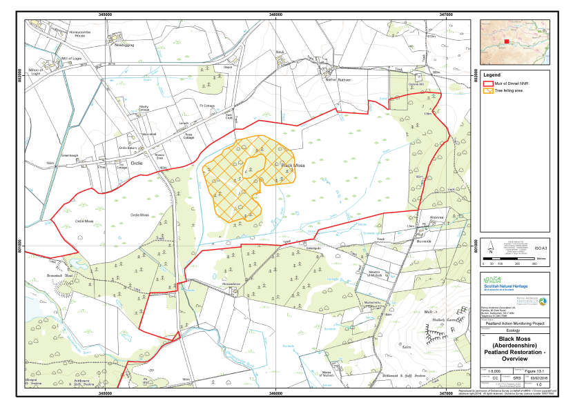
Figure 32. An overview of the peatland restoration conducted at Black Moss, Aberdeenshire
Click for a full description
On an OS basemap, a hashed orange polygon indicates an area of tree felling within the Muir of Dinnet National Nature Reserve boundary, which is delineated in red.
Monitoring strategy
The sampling strategy was designed to monitor the change in vegetation after tree removal was undertaken on the raised bog habitat. Samples were taken equally across three separate areas, the first a drier M19 bog with tree cover, the second a wooded area of bog (W18) and a third area also wooded M19 bog but not to be subject to tree felling (the unmanaged control). Each sample plot was allocated an area code (A, B and C, respectively); these are outlined below:
- Area A - Clearance of trees from M19 bog;
- Area B - Clearance of trees from dry W18 wooded bog; and
- Area C - Control (M19 Bog).
In each area a total of 20 2m x 2m quadrats were collected across a homogenous stand of the main vegetation type within the treated area. Quadrats were sampled randomly within the homogeneous vegetation stand. The abundances of all plant species were recorded as percent cover. A number of environmental and vegetation community measurements were also taken, including cover of bare peat, vegetation height and presence of dung (see Annex I for further details).
The quadrat sample set (60 quadrats across Area A, B and C) allows for robust statistical analysis of vegetation community change over time and between the three sample areas.
Fixed point photographs of each area were taken to supplement the 2m x 2m quadrat samples.
Baseline survey results
Table 14 presents a summary of the plant species recorded in each of the four sample areas along with their abundance (DAFOR scale). Quadrat data are presented in Annex II and their locations area shown on Figure 33. The fixed point photographs are presented within Annex III and their locations shown on Figure 34. Each sample area is described below.
Table 14. Abundance of plants recorded in the sample plots, Black Moss, Aberdeenshire, 2014
|
Common name |
Scientific name |
Area A |
Area B |
Area C |
|---|---|---|---|---|
|
Bilberry |
Vaccinium myrtillus |
- |
R |
- |
|
Bog-myrtle |
Myrica gale |
- |
- |
A-LD |
|
Common cottongrass |
Eriophorum angustifolium |
F |
O-LF |
O |
|
Cowberry |
Vaccinium vitis-idaea |
R |
- |
- |
|
Cross-leaved heath |
Erica tetralix |
A |
F |
A |
|
Crowberry |
Empetrum nigrum |
R |
- |
- |
|
Downy birch |
Betula pubescens |
- |
A |
F |
|
Hare's-tail cottongrass |
Eriophorum vaginatum |
A-LD |
- |
A-LD |
|
Heather |
Calluna vulgaris |
A |
F-A |
F-A |
|
Round-leaved sundew |
Drosera rotundifolia |
R-O |
- |
- |
|
Scots pine |
Pinus sylvestris |
F |
A |
F |
|
Silver birch |
Betula pendula |
F |
- |
- |
|
A bog moss |
Sphagnum capillifolium ssp. capillifolium |
A |
O |
A-LF |
|
A bog moss |
Sphagnum capillifolium ssp. rubellum |
A |
R |
A-LF |
|
A bog moss |
Sphagnum cuspidatum |
O |
O |
- |
|
A bog moss |
Sphagnum denticulatum |
R |
- |
- |
|
A bog moss |
Sphagnum fallax |
R |
O |
- |
|
A bog moss |
Sphagnum fimbriatum |
- |
R |
|
|
A bog moss |
Sphagnum magellanicum |
- |
- |
R-O |
|
A bog moss |
Sphagnum palustre |
R |
R |
- |
|
A bog moss |
Sphagnum papillosum |
- |
- |
O |
|
A bog moss |
Sphagnum subsecundum |
O |
- |
- |
|
A bog moss |
Sphagnum tenellum |
- |
- |
R |
|
A lichen |
Cladonia arbuscula |
A-LD |
F |
- |
|
A lichen |
Cladonia pyxidata |
- |
R-O |
R |
|
A lichen |
Cladonia rangiformis |
R |
R |
- |
|
A lichen |
Cladonia sp. |
- |
- |
O |
|
A lichen |
Parmelia sp. |
O |
R-O |
- |
|
A liverwort |
Liverwort |
- |
- |
O |
|
A moss |
Aulacomnium palustre |
- |
- |
O |
|
A moss |
Campylopus flexuosus |
- |
R |
- |
|
A moss |
Dicranum scoparium |
- |
R |
R |
|
A moss |
Hylocomium splendens |
O |
A |
O-F |
|
A moss |
Hypnum jutlandicum |
O |
- |
O |
|
A moss |
Pleurozium schreberi |
A |
F |
F |
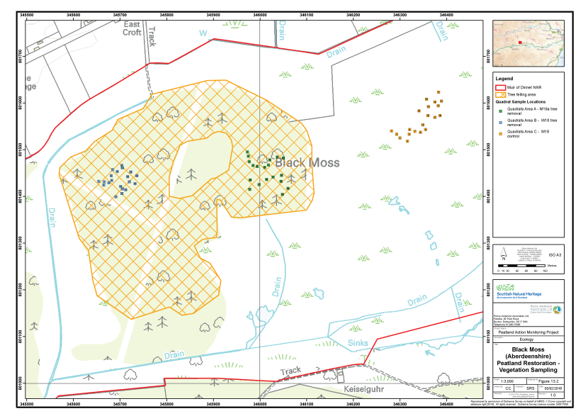
Figure 33. The vegetation survey quadrat locations at Black Moss, Aberdeenshire
Click for a full description
On an OS basemap, a hashed orange polygon indicates an area of tree felling within the Muir of Dinnet National Nature Reserve boundary, which is delineated in red.
The locations of three clusters of vegetation survey quadrats are shown as numbered squares:
- Area A – M19a tree removal, in green
- Area B – W18 tree removal, in blue
- Area C – M19 control, in orange.
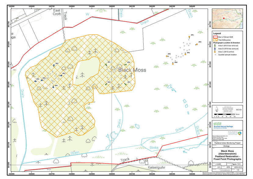
Figure 34. The locations of fixed point photography at Black Moss, Aberdeenshire
Click for a full description
On an OS basemap, a hashed orange polygon indicates an area of tree felling within the Muir of Dinnet National Nature Reserve boundary, which is delineated in red.
The locations of three clusters of fixed point photography points are shown as filled circles with arrows indicating the direction the photographer faced:
- Area A – M19a tree removal, in green
- Area B – W18 tree removal, in blue
- Area C – M19 control, in orange.
Area A - M19 Bog subject to tree removal
This area of raised bog with firm peat was dominated by Scot’s pine and birch with abundant heather and cross-leaved heath below at a height of 20 – 30cm tall (although bog-myrtle that is abundant elsewhere on the site was absent). Hare’s-tail cottongrass is abundant to locally dominant along with abundant to locally dominant Cladonia arbuscula.
Sphagnum species occur across the area within lawns, hummocks and hollows with the main species being both subspecies of Sphagnum capillifolium along with a number of species of wetter situations (S. denticulatum, S. subsecundum and S. cuspidatum) in a series of small hollows across the area (possibly former peat cutting areas). Sphagnum fallax is occasional.
There are occasional field signs of deer across the area but no significant impacts of grazing on the vegetation were noted.
The vegetation is considered to be most similar to M19a Calluna vulgaris - Eriophorum vaginatum blanket mire, Erica tetralix sub-community (Rodwell 1991) with regenerating birch from nearby ancient birch woodlands and Scot’s pine from nearby old plantations. A total of 20 quadrats were taken within this vegetation type along with 4 fixed point photographs.
Area B - W18 Wooded bog subject to tree removal
The sample area comprised the driest area of the raised bog which had a significant woodland cover comprising semi-mature trees of Scot’s pine and birch although still over deep peats. The ground is very firm and dry underfoot with the ground flora dominated by abundant heather, cross-leaved heath, Hylocomium splendens and Pleurozium schreberi, among which there is a significant cover of litter comprising largely pine needles and fallen twigs. The heather has developed to a building to mature canopy although it is grazed and suppressed in some area probably by deer.
There are occasional bare peat areas across the site. In addition, some wetter areas and hollows are present across the area which may have been formed from the uprooted boles of fallen trees. In these areas Sphagnum fallax, S. palustre and S. cuspidatum have colonised as low mats and within shallow pools along with common cottongrass. Other species of Sphagnum are sparse with only occasional low hummocks of Sphagnum capillifolium ssp. capillifolium.
The vegetation is considered to be most similar to W18 Pinus sylvestris – Hylocomium splendens woodland (Rodwell 1992) with regenerating birch from nearby ancient birch woodlands and Scot’s pine from nearby old plantations. A total of 20 quadrats were taken within this vegetation type along with five fixed point photographs.
Area C – M19 Bog unmanaged control
The sample area has a relatively open canopy of frequent Scot’s pine and birch with an understorey dominated by bog-myrtle, cross-leaved heath, and heather with tussocks of common cottongrass.
There is a good cover of Sphagnum with abundant Sphagnum capillifolium (both subspecies) with occasional low hummocks of S. papillosum and more rarely S. magellanicum. Other mosses include Hylocomium splendens and Pleurozium schreberi, with occasional Hypnum jutlandicum and Aulacomnium palustre.
The vegetation is considered to be most similar to M19a Calluna vulgaris - Eriophorum vaginatum blanket mire, Erica tetralix sub-community (Rodwell 1991) with regenerating birch from nearby ancient birch woodlands and Scot’s pine from nearby old plantations. A total of 20 quadrats were taken within this vegetation type along with five fixed point photographs.
Constraints on survey
No constraints on the survey were noted.
Assessment of restoration approach
The collection of a pre-treatment quadrat dataset and the inclusion of an untreated control at this site provide a sound baseline dataset for future monitoring of the effects of tree removal on the site. The areas of the bog within the way-leave of overhead power cables is kept largely free of trees and this area is significantly wetter and has greater cover of Sphagnum than the three areas sampled for the baseline survey. This indicates that tree removal has the potential to significantly increase water levels on the site and support active bog regeneration.
There may be some temporary drying of the bog surface and any Sphagnum carpets after tree removal during the summer months as the surface is less shaded, but this is likely to resolve after the first winter with Sphagnum cover responding favourably (Brooks and Stoneman 1997).
Monitoring is recommended immediately after tree removal to identify the effects of the operations and enable early re-colonisation to be tracked. Installation of some dipwell monitoring points would be a useful supplement to the monitoring programme.
Black Moss (West Lothian)
Overview of the site
Black Moss is a 22ha raised bog, situated at the western edge of Armadale, West Lothian (Figure 35). The site is not subject to any statutory nature conservation designations and is mostly owned by West Lothian Council. The western part of the bog is in private ownership.
Various industrial operations have affected Black Moss over the last 200 years. These include the construction of a reservoir on the site and the subsequent extraction of the coal and clay deposits that were discovered. Some peat cutting has taken place and more recently, the central part of the moss was ploughed in preparation for forestry. Most was left after ploughing, but a small area in the northern part of the site was planted with Lodgepole pine. The western part of the moss is fenced and lightly grazed, but there are no recent records of grazing on the part owned by West Lothian Council.
Online aerial photography shows that the moss has a history of burning. Various burns can be identified probably all resulting from arson, but in the past, controlled burning may also have been practiced. Blackened cottongrass tussocks and a carpet of very young heather suggested an area in the eastern part of the moss had been burnt within a year or two of the survey.
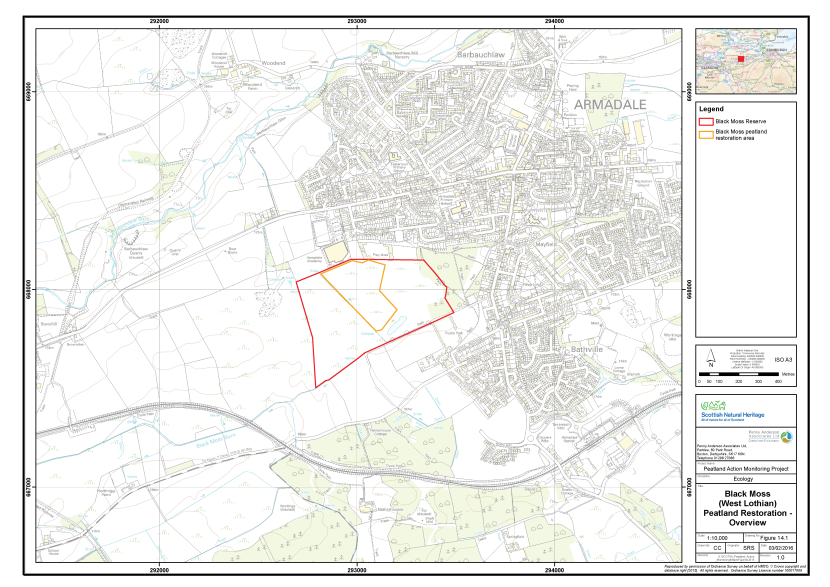
Figure 35. Overview of the peatland restoration conducted at Black Moss (West Lothian)
Click for a full description
On an OS basemap, an orange polygon indicates the peatland restoration area within the Nature Reserve boundary, which is delineated in red.
Existing monitoring on site
Various ecological surveys of Black Moss and the surrounding area have been previously undertaken, however no formal monitoring of the site is documented. During the restoration works undertaken under the Peatland Action programme, a dipwell was positioned near to the north end of the forestry ditches, just to the east of the Main ditch.
A management plan, produced by Biodiversity Solutions (Sommerville 2015) recommended monitoring of various attributes of the site. In addition to a regular download of the dipwell data, the monitoring measures recommended comprise regular walk over surveys to assess the condition of dams and the extent of tree regeneration. The management plan also recommends that a National Vegetation Classification (NVC) survey of the site is completed every five years to quantify change in the habitats.
Restoration measures undertaken
Restoration work under the Peatland Action programme took place between January and March 2015 on the part of Black Moss owned by West Lothian Council. The main objectives of restoration were to help restore the natural hydrology of the site and to improve the water-holding capacity of the raised bog. The works covered an area of 7.5ha and comprised two main treatments. A Restoration Report has been produced, detailing the work undertaken (Anon 2015).
Approximately 0.5ha of immature pine plantation in the northern part of the site was felled using a combination of hand pulling and sawing for smaller trees and the use of an excavator to smash the stems of more mature trees. The resulting tree fragments and brash were left in situ and tracked over with the excavator to compact them. The root plates of the larger trees were excavated, upturned and embedded in the plough furrows, as dams. Approximately 60 peat dams were also created to the east and west of the pine plantation. The aim of this measure was to remove the tree cover and use the arisings to block drains in order to raise the water table.
The central area of the site had been prepared for afforestation but never planted. Prior to treatment this area consisted of a series raised plough ridges shallow sunken furrows. The main restoration measure comprised stripping turves from the plough ridges and using them to infill the adjacent furrows. Pictures taken before and after the works and presented in the final report suggest that, in winter at least, the bases of the furrows lay below the water table, whereas the tops of the ridges were above it. During the works, turves were stripped from the plough ridges and placed in the adjacent furrow, leaving the excavated ridges bare. The aim of this measure was to even the surface of the site and to bring the surface of the bog into closer contact with the water table.
Monitoring of the restoration measures was carried out between 28th and 29th September 2015 by Alistair Blackshaw and Dr Sarah Ross.
Monitoring strategy
The sampling strategy was designed to monitor change in vegetation after the restoration measures had been applied. A total of four samples were taken, each allocated an Area code (A, B, C and D respectively). Three of the Areas had been treated, a fourth area comprised the reference site. The Areas are outlined below:
- Area A - Pine clearance (Post-treatment sample);
- Area B - Stripped and excavated plough ridges (Post-treatment sample);
- Area C - Infilled plough furrows (Post-treatment sample); and
- Area D - Relatively unmodified and wet bog (Reference).
In each of Areas B-D, a total of 15 2m x 2m quadrats were collected across the main vegetation Quadrat sampling targeted homogeneous areas of vegetation, typical of the feature. Quadrats were sampled randomly within the homogeneous vegetation stand. The abundances of all plant species were recorded as percent cover. A number of environmental and vegetation community measurements were also taken, including cover of bare peat, vegetation height and presence of dung (see Annex I for further details).
The quadrat survey targeted several aspects of the restoration approaches, which varied by Area. In Areas B and C, the lines of the stripped plough ridges and the lines of the infilled furrows were sampled respectively. Sampling in this way provided post-treatment baseline datasets for both areas, to allow assessment of whether the vegetation of these subtly different features changes differentially over time. In Area D, a community type typical of the better quality raised bog vegetation on site was sampled to provide a reference site. Area A was sampled using fixed point photography. It was considered that photographs were the most appropriate way to sample this area, because it was covered with brash and there was little vegetation re-growth to sample.
Sampling was undertaken approximately six months after the treatments had been applied, therefore providing a good baseline for future monitoring of change in the vegetation of Areas A, B and C. The reference site (Area D) will enable an assessment of how similar the vegetation communities of the treated areas are to relatively unmodified bog in future years. The quadrat sample set (45 quadrats across Areas B, C and D) allows for robust statistical analysis of change in the vegetation communities change over time.
Fixed point photographs of Areas B, C and D were taken to supplement the 2m x 2m quadrat samples.
Baseline survey results
Table 15 presents a summary of the plant species recorded in each of the three sample areas along with their abundance (DAFOR scale). Quadrat data are presented in Annex II and their locations area shown on Figure 36. The fixed point photographs are presented within Annex III and their locations shown on Figure 37. Each sample area is described below.
Table 15. Abundance of plants recorded in the sample plots, Black Moss, West Lothian 2015
|
Common Name |
Scientific Name |
Area A |
Area B |
Area C |
Area D |
|---|---|---|---|---|---|
|
Bare peat |
- |
- |
D |
F |
- |
|
Silver birch |
Betula pendula |
O |
- |
- |
- |
|
Downy birch |
Betula pubescens |
R |
- |
- |
R |
|
Heather |
Calluna vulgaris |
A |
R |
A - LD |
A |
|
Heather (dead) |
Calluna vulgaris (dead) |
- |
- |
|
A |
|
Wavy hair-grass |
Deschampsia flexuosa |
- |
- |
O |
O |
|
Round-leaved sundew |
Drosera rotundifolia |
- |
R |
R |
O |
|
Crowberry |
Empetrum nigrum |
F |
- |
- |
- |
|
Cross-leaved heath |
Erica tetralix |
O |
- |
O |
F |
|
Common cottongrass |
Eriophorum angustifolium |
|
F |
F |
A |
|
Hare's-tail cottongrass |
Eriophorum vaginatum |
F |
R |
F |
A |
|
Purple moor-grass |
Molinia caerulea |
A |
- |
LF |
R |
|
A pine |
Pinus sp. |
O |
- |
- |
- |
|
Grey willow |
Salix cinerea |
- |
- |
- |
R |
|
Cranberry |
Vaccinium oxycoccos |
- |
- |
- |
R |
|
A moss |
Aulacomnium palustre |
- |
- |
- |
R |
|
A moss |
Campylopus flexuosus |
- |
O |
F |
- |
|
A moss |
Campylopus introflexus |
- |
- |
O |
- |
|
A moss |
Hypnum jutlandicum |
O |
- |
- |
- |
|
A moss |
Polytrichum commune |
LF |
O |
- |
F |
|
A moss |
Polytrichum strictum |
- |
- |
- |
A |
|
A bog moss |
Sphagnum capillifolium subsp rubellum |
- |
- |
- |
O |
|
A bog moss |
Sphagnum cuspidatum |
- |
- |
- |
O |
|
A bog moss |
Sphagnum fallax |
LF |
- |
- |
A |
|
A bog moss |
Sphagnum magellanicum |
- |
- |
- |
F |
|
A bog moss |
Sphagnum papillosum |
O |
R |
O |
A |
|
A bog moss |
Sphagnum subnitens |
- |
- |
O |
- |
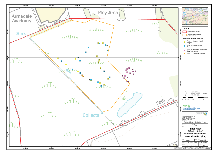
Figure 36. The vegetation survey quadrat locations at Black Moss (West Lothian)
Click for a full description
On an OS basemap, an orange polygon indicates the peatland restoration area within the Nature Reserve boundary, which is delineated in red.
The locations of the vegetation survey quadrats are represented by numbered, filled squares:
- Area B, in yellow, stripped plough ridges;
- Area C, in blue, infilled plough ridges;
- Area D, in pink, relatively unmodified bog (reference);
- Area E, in orange, additional samples.
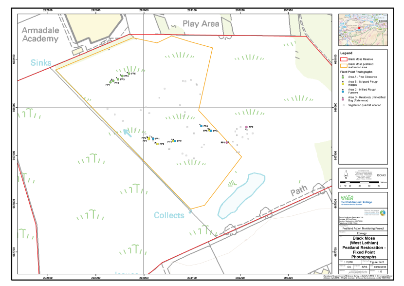
Figure 37. The locations of fixed point photography at Black Moss (West Lothian)
Click for a full description
On an OS basemap, an orange polygon indicates the peatland restoration area within the Nature Reserve boundary, which is delineated in red.
The locations of the fixed point photography are represented by numbered, filled circles with an arrow indicating the direction the photographer faced:
- Area A, in green, pine clearance;
- Area B, in yellow, stripped plough ridges;
- Area C, in blue, infilled plough ridges;
- Area D, in pink, relatively unmodified bog (reference).
Area A - Pine clearance
This sample plot comprises the area previously occupied by a small pine plantation, at the northern edge of the central part of Black Moss. The plantation had been felled and a number of the larger tree stumps upended and packed into the furrows. Dense piles of brash covered approximately 40% - 50% of the bog surface. Purple moor-grass, hare’s-tail cotton grass and heather were regenerating on the drier ridges between the accumulations. In the furrows, the remains of Sphagnum carpets that were likely present prior to the works persisted in places, but where there had been gross disturbance, for example around the upended root plates, any remaining bog moss was in poor condition.
Area B - Stripped and excavated plough ridges
This sample plot included only the parts of the plough ridges, which had been stripped of turf, to provide infill material for the adjacent furrows. The ‘scalped’ parts of the ridges were identified as stripes of exposed bare peat approximately 1.0m - 1.5m wide on average, distributed relatively evenly across the central part of the site. The surface of an average scalped area was approximately 0.15m - 0.25m lower than the surrounding ground, which comprised either infilled furrow, or intact plough ridge. Average vegetation cover was less than 10% and mainly comprised straggling common cottongrass, hare’s-tail cottongrass and heather.
Area C - Infilled plough furrows
This sample plot included only the turves that had been translocated to infill the plough furrows. The turves appeared to have been translocated without major damage and were representative of the intact parts of the plough ridges. Their vegetation mainly comprised heather, common cottongrass, hare’s-tail cottongrass together with the moss Campylopus flexuosus and the bog moss Sphagnum papillosum. Other species included purple moor-grass and the mosses Polytrichum strictum, Hypnum jutlandicum, and the bog mosses Sphagnum capillifolium subsp. rubellum and S. capillifolium subsp. capillifolium.
Area D - Reference
This sample area is located in the southern part of the site, just to the east of the restoration area and north of the fen. The vegetation showed strong affinities to typical M18 blanket bog, with constant hare’s-tail cottongrass, heather, cross-leaved heath and round-leaved sundew. Of the bog mosses, Sphagnum papillosum was constant throughout, attaining 40% cover or more in some quadrats. S. fallax was also very frequent, but S. capillifolium sensu lato was infrequent. Some die-back of heather, probably due to fire, was also noted.
Constraints on survey
No significant constraints on survey or access were noted. It was possible to park in the housing estate to the north and easily walk onto the site from the football pitch.
Assessment of restoration approach
Growth of pine in Area A has been reduced by felling, with only occasional saplings remaining. In terms of re-wetting the site and restoring peat-forming vegetation, however, the interventions were considered to have been less successful. No evidence of pooling in the plough furrows was seen. The brash that had been placed into the furrows was not holding water back as effectively as a dam constructed from peat or plastic would. It was considered that upturned root-plates might slow any water flow but were not suitable as dams because their irregular shapes had prevented them from being properly keyed into the sides and bases of the drains. The process had also caused significant damage to rafts of Sphagnum species which had been present in the furrows prior to the works.
The thick accumulation of brash lying on the bog surface in Area A is likely to delay the colonisation by typical bog vegetation. The brash mats will need to rot completely before the surface is available for colonisation. However, the rotting material and the nutrients it releases are likely to significantly alter the growing medium in the meantime. There is significant risk the vegetation of Area A will go through a ‘weedy’ phase where a community that is not typical of raised bog will dominate. Subsequent vegetation succession in this community may be towards birch woodland rather than bog.
There was no direct evidence that the combination treatment of partial scalping of the plough ridges and infilling of the adjacent furrows had raised the water table of the central area of the site. On the contrary, the treatment had exposed significant areas of bare peat, some of which had cracked due to surface drying. The major limitation of the infilling treatment is that the furrows were blocked with turf. The turf would have been comprised of relatively loose acrotelm peat permeated by vegetation roots. On this basis, the furrows may still be partially functional as drainage pathways, because the relatively porous peat of the turves is likely to be poorly bonded to sides and bottoms of the furrows, allowing additional flow of water.
Infilling the ditches is likely to have damaged the main source of Sphagnum propagules in the ploughed area. A photograph taken prior to the works clearly shows some significant accumulations of bog moss in the furrows which would have been covered over and therefore destroyed by turfing.
A re-survey of the site in 2017 would be a suitable timeframe for monitoring of the Peatland Action funded work.
Carsegowan Moss
Overview of the site
Carsegowan Moss is a 50ha raised bog located 3km north of Wigtown, in Dumfries and Galloway (Figure 38). The site is classified as both a SSSI and SAC on account of its lowland raised bog habitats (SNH 2010b). The majority of the site is managed by the Scottish Wildlife Trust (SWT).
During the past century the moss was partially drained and may have been subject to some grazing and peat cutting around its drier edges. The lagg area at the periphery of the bog has been invaded by woodland and is now very dry. Farmland has also encroached on the lagg, particularly to the south and west of the peat dome.
Extensive coniferous plantation has been established to the north of Carsegowan Moss, between the site and the Bishop Burn. The site has also been subject to forestry operations, with Scots pine planted in the open bog, which is now standing dead wood. Woodland to the north of the site hides a series of concrete and brick buildings which operated as part of a black powder works during the Second World War. A railway servicing this facility is reputed to have caused frequent fires on the moss.
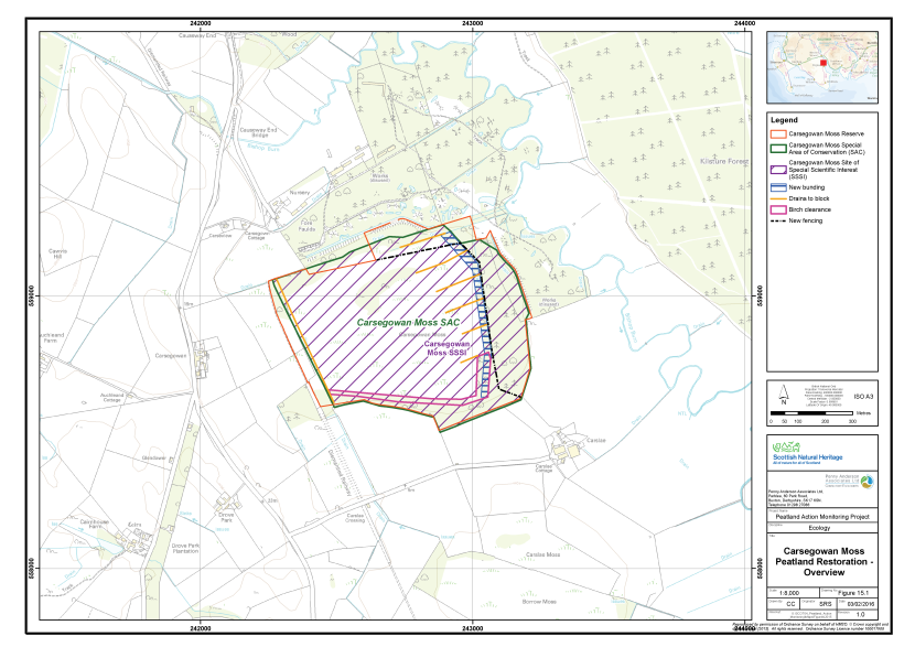
Figure 38. Overview of the peatland restoration and designated areas at Carsegowan Moss
Click for a full description
The Carsegowan Moss reserve is delineated in red on an OS basemap. A green polygon indicates the Carsegowan Special Area of Conservation, and a purple hashed polygon represents the Carsegowan Moss Special Area of Scientific Interest.
Peatland restoration features and new fencing are shown on the eastern portion of the reserve:
- New bunding is represented with a blue hashed polygon;
- Drains to be blocked are represented by orange lines;
- Birch clearance is represented by an open purple polygon;
- New fencing is represented with a dashed black line.
Existing monitoring on site
SWT carried out a vegetation survey of the site in 2002, defining and mapping the NVC communities present. This survey categorised the majority of the site as M18 Cross-leaved heath – Sphagnum papillosum raised and blanket mire, with M2 Sphagnum cuspidatum / S. fallax bog-pool community. Small areas of M15 deergrass – cross-leaved heath wet heath were also recorded. The birch woodland at the edge of the bog was classified as W4 downy birch – purple-moor grass woodland.
Site Condition Monitoring (SCM) surveys of the site were undertaken by NatureScot in 2007 and 2012. In both instances, the overall condition of the raised bog was assessed as being unfavourable, no change. The main reason for failure was that the cover of undesirable woody species birch, pine and rhododendron (Rhododendron ponticum) was too high. Although met in 2007, the site failed the target for positive indicator species in 2012, indicating a downward trend in species-richness. However, the 2012 survey found that the cover of positive bryophyte indicator species had increased since 2007 and the cover of negative indicator species including bracken (Pteridium aquilinum) and rushes had declined.
Restoration measures undertaken
Management has been carried out at the site by SWT for a number of years, particularly after a Scottish Rural Development Programme (SRDP) agreement, which ran between 2009 and 2014. Work undertaken on the site included scrub removal and the blocking of drains with plastic piling, with the aim of raising the water table.
Restoration work at Carsegowan Moss under the Peatland Action programme included the following measures:
- Bunding of drains with peat. This treatment was applied to a large drain in the western part of the site and has been carried out along the eastern and southern edges of the moss.
- Tree clearance along the southern edge was also planned, but had not been carried out at the time of the survey.
Monitoring of the restoration measures was carried out between 24th and 25th August 2015 by Alistair Blackshaw and Helen Hamilton (Principal Ecologist, MCIEEM, CEnv).
Monitoring strategy
The strategy was designed to monitor the change in vegetation after the treatments had been applied. A total of four samples were taken, each allocated an Area code (A, B, C and D respectively). Two of the Areas had been treated, a third area comprised an untreated reference and the final area had not yet been treated. The Areas are outlined below:
- Area A - Peat bunds along edge of bog (Post-treatment sample);
- Area B - Peat bunds along former drain (Post-treatment sample);
- Area C - Relatively unmodified bog (Reference); and
- Area D - Birch clearance (Pre-treatment baseline).
In each of the four sample areas, a total of 15 2m x 2m quadrats were collected across a homogenous stand of the main vegetation type within the treated area. Quadrats were sampled randomly within the homogeneous vegetation stand. The abundances of all plant species were recorded as percent cover. A number of environmental and vegetation community measurements were also taken, including cover of bare peat, vegetation height and presence of dung (see Annex I for further details).
The quadrat survey targeted specific aspects of the vegetation in the different areas. In Areas A and B, sampling was focused on the purple moor-grass-dominated vegetation, as it was considered that the aim of each treatment was to reduce the dominance of this species by raising the water table. In Area C, sampling took place within an area of blanket bog vegetation that was considered representative of relatively unmodified bog on the site. In Area D, the ground flora of the standing woodland was sampled, as this vegetation would form the starting point for reversion to raised bog following tree clearance.
Sampling was undertaken approximately six to nine months after the treatments had been applied, therefore providing a good baseline for future monitoring of change in the vegetation of the Areas A and B. The reference site (Area C) will enable an assessment of how similar the vegetation communities of the treated areas are to relatively unmodified bog in future years. The pre-treatment sample in Area D will provide a baseline against which post-clearance monitoring data can be compared in the future. The quadrat sample set (60 quadrats across Areas A, B, C and D) allows for robust statistical analysis of change in the vegetation communities change over time.
Fixed point photographs of each area were taken to supplement the 2m x 2m quadrat samples.
Baseline survey results
Table 16 presents a summary of the plant species recorded in each of the four sample areas along with their abundance (DAFOR scale). Quadrat data are presented in Annex II and their locations are shown on Figure 39. The fixed point photographs are presented within Annex III and their locations shown on Figure 40. Each sample area is described below.
Table 16. Abundance of plants recorded in the sample plots, Carsegowan Moss, 2015
|
Common Name |
Scientific Name |
Area A |
Area B |
Area C |
Area D |
|---|---|---|---|---|---|
|
Bilberry |
Vaccinium myrtillus |
O |
O |
- |
- |
|
Bog myrtle |
Myrica gale |
A |
F |
- |
F |
|
Bog rosemary |
Andromeda polifolia |
- |
R |
F |
- |
|
Broad buckler-fern |
Dryopteris dilatata |
R |
- |
R |
A |
|
Common cottongrass |
Eriophorum angustifolium |
R |
R |
F |
O |
|
Cranberry |
Vaccinium oxycoccos |
- |
O |
F |
- |
|
Cross-leaved heath |
Erica tetralix |
O |
F |
A |
O |
|
Downy birch |
Betula pubescens |
R |
O-F |
F |
- |
|
Hairy woodrush |
Luzula pilosa |
- |
- |
- |
F |
|
Hare's-tail cottongrass |
Eriophorum vaginatum |
O |
F |
A |
F |
|
Heather |
Calluna vulgaris |
LA |
- |
A |
- |
|
Purple moor-grass |
Molinia caerulea |
A-D |
D |
- |
LA |
|
Spruce |
Picea sp. |
- |
R |
- |
- |
|
White beak-sedge |
Rhynchospora alba |
- |
- |
R |
- |
|
A moss |
Aulacomnium palustre |
- |
R |
- |
A |
|
A moss |
Dicranum scoparium |
R |
- |
O |
- |
|
A moss |
Hypnum jutlandicum |
F |
- |
F |
F |
|
A moss |
Kindbergia praelonga |
- |
- |
- |
O |
|
A moss |
Polytrichum commune |
R |
- |
- |
- |
|
A moss |
Polytrichum strictum |
- |
- |
F |
- |
|
A moss |
Rhytidiadelphus squarrosus |
- |
- |
|
O |
|
A bog moss |
Sphagnum capillifolium subsp capillifolium |
- |
- |
O |
- |
|
A bog moss |
Sphagnum capillifolium subsp rubellum |
F |
F |
A |
A |
|
A bog moss |
Sphagnum cuspidatum |
- |
- |
R |
- |
|
A bog moss |
Sphagnum fallax |
R |
- |
- |
- |
|
A bog moss |
Sphagnum fimbriatum |
R |
- |
- |
R |
|
A bog moss |
Sphagnum magellanicum |
- |
- |
A |
|
|
A bog moss |
Sphagnum palustre |
R |
- |
- |
LD |
|
A bog moss |
Sphagnum papillosum |
- |
O-F |
F |
- |
|
A bog moss |
Sphagnum pulchrum |
- |
- |
LF |
- |
|
A bog moss |
Sphagnum subnitens |
- |
O-F |
R |
- |
|
A bog moss |
Sphagnum tenellum |
- |
- |
F |
- |
|
A lichen |
Cladonia portentosa |
- |
- |
F |
- |
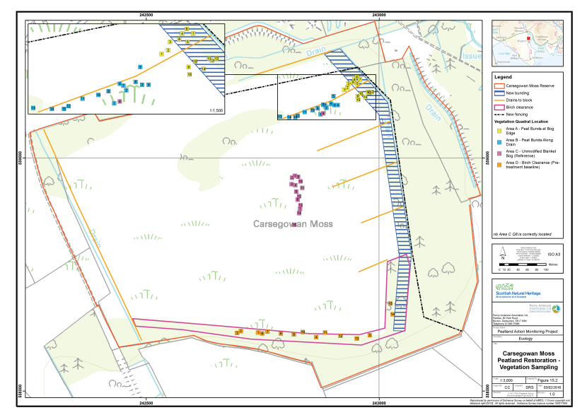
Figure 39. The vegetation survey quadrat locations at Carsegowan Moss
Click for a full description
The Carsegowan Moss reserve is delineated in red on an OS basemap.
Peatland restoration features and new fencing are shown:
- New bunding is represented with a blue hashed polygon;
- Drains to be blocked are represented by orange lines;
- Birch clearance is represented by an open purple polygon;
- New fencing is represented with a dashed black line.
Four clusters of filled, numbered squares indicate the locations of the vegetation survey quadrat locations:
- Area A, in yellow, peat bunds at the bog edge;
- Area B, in blue, peat bunds along a drain;
- Area C, in pink, unmodified raised bog (reference);
- Area D, in orange, Birch clearance (pre-treatment baseline).
An inset map shows a zoomed in view of Areas A and B.
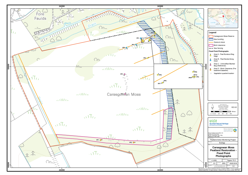
Figure 40. The locations of fixed point photography at Carsegowan Moss
Click for a full description
The Carsegowan Moss reserve is delineated in red on an OS basemap.
- Peatland restoration features and new fencing are shown:
- New bunding is represented with a blue hashed polygon;
- Drains to be blocked are represented by orange lines;
- Birch clearance is represented by an open purple polygon;
- New fencing is represented with a dashed black line.
The locations of the fixed point photography are represented by numbered, filled circles with an arrow indicating the direction the photographer faced:
- Area A, in yellow, peat bunds at the bog edge;
- Area B, in blue, peat bunds along a drain;
- Area C, in pink, unmodified raised bog (reference);
- Area D, in orange, Birch clearance (pre-treatment baseline).
An inset map shows a zoomed in view of some of the fixed point photography locations in area A.
The locations of the vegetation survey quadrats are shown as filled grey squares.
Area A - Peat bunds at bog edge
This sample plot lies at the north-eastern edge of Carsegowan Moss within an area that has been colonised by purple moor-grass. The treatment has involved stripping the top layer of peat to approximately 0.25 - 0.5m depth. The excavated peat has been used to create bunds to hold back water in the stripped areas. In order to sample the effect of the treatment on raising the water table in this drier area of bog, vegetation adjacent to the bunded areas was sampled.
Vegetation adjacent to the bunded areas was characteristic of the drier peat at the eastern periphery of the site and was dominated by purple moor-grass with locally abundant heather and occasional bilberry, cross-leaved heath and hare’s-tail cottongrass. Sphagnum capillifolium was frequent and downy birch was colonising in places, where the purple moor-grass cover was thin enough.
Area B - Peat bunds along drain
This sample plot comprised purple moor-grass-dominated vegetation along a former drain, originating in the pine plantation to the west. Horseshoe-shaped bunds have been constructed across the drain using peat excavated from behind the dam location. Water was pooling behind the dams at the time of the survey, although aquatic Sphagnum species were infrequent in the pools.
The sampled vegetation was characteristic of drier peats and dominated by purple moor-grass with locally abundant heather, frequent cross-leaved heath and hare’s-tail cottongrass and occasional bilberry. Sphagnum capillifolium and Sphagnum papillosum were occasional to frequent, but cushions were often in poor condition due to the effect of shade cast by the tall purple moor-grass. Downy birch was colonising in places, where the purple moor-grass cover was sparser.
Area C - Reference
Area C comprised a relatively intact area, approximately 200m from the eastern edge of the site. The vegetation was good quality M18 showing co-dominance of hare’s-tail cottongrass, heather, cross-leaved heath, Sphagnum capillifolium subsp. rubellum, Sphagnum magellanicum and Sphagnum papillosum. The sample area is notable for the abundance of bog rosemary and, in the wetter hollows, the scarce bog moss Sphagnum pulchrum. Although the vegetation was of good quality in general, downy birch seedlings and saplings were frequent throughout.
Area D - Birch clearance
This sample plot comprised a stand of young birch woodland on deep peat, comprising the rand of the bog at its southern edge. Plans received from NatureScot indicated that the woodland would be cleared as part of the restoration measures, although no clearance had been undertaken at the time of the survey.
The canopy of the woodland was around 8m tall and dominated by downy birch, comprising approximately 75% cover. The ground flora comprised patches of purple moor-grass, together with open areas referable to both woodland and bog vegetation and leaf litter from the birch canopy. Typical bog species included frequent hare’s-tail cottongrass with cross-leaved heath, Sphagnum capillifolium subsp. rubellum, and Sphagnum magellanicum. Woodland species in addition to the trees included hairy woodrush (Luzula pilosa) and locally abundant broad buckler fern (Dryopteris dilatata).
Constraints on survey
Bird nesting restrictions may apply on this site. It is necessary to liaise with the SWT officer responsible for the site before accessing the moss.
Assessment of restoration approach
Future monitoring datasets will enable post-treatment change over time in the vegetation of the bunded bog edge (Area A) and the bunded drain (Area B) to be monitored closely. If the birch woodland (Area D) is felled, the sample taken in 2015 will form a valuable pre-treatment baseline against which future datasets for this area can be compared. It will be possible to compare change in the treated areas with the reference site (Area C), to provide an assessment of whether vegetation in the treated areas becomes more similar to unmodified bog typical of the local area.
Pre-treatment aerial photography suggests Area A was previously dominated by a purple moor-grass and heather mix. The increase in standing water as a result of peat stripping and bunding represents a significant change in this vegetation. It was considered to soon to comment on whether the treatment would be likely to have an affect on the water table of adjacent areas, however, colonisation of Sphagnum species within the wet bunded cells is expected. Likewise, it was too soon after treatment to detect a change in Area B. However, the bunds were holding water, which suggested they may be effective in raising the water table in the long-term. It is likely that any change will be relatively slow as purple-moor grass is very dominant in these areas.
Invasion by trees, particularly downy birch, is considered the biggest threat to the condition of Carsegowan Moss. Even the richest areas of the site have frequent cover of seedlings and saplings. As the trees grow their negative impact will increase, through shading of desirable species and drying of the upper layer of peat through increased evapotranspiration. The bog is surrounded by birch woodland, some of it on deep peat, and therefore receives considerable seed rain. The peripheral woodland has caused drying of the lagg area which would have been important in buffering drainage from the raised bog.
It is considered that cutting back this woodland, particularly from the rand of the bog, but also in the lagg zone, and damming any drainage channels within it should also be considered a priority for restoring bog vegetation and increasing resilience to tree invasion in the future. Implementation of birch clearance in Area D as planned is considered to be a good starting point. It is recommended that clearance should be total, with trees and brash removed and chipped away from the bog. Measures to control the ongoing encroachment of scrub in the meantime are recommended. This could include correctly timed, light grazing.
A re-survey of the site in 2017 would be a suitable timeframe for monitoring.
Flanders Moss
Overview of the site
Flanders Moss is a large (859ha) raised bog with areas of primary intact bog, degraded areas capable of restoration, endotelmic streams, areas of rand and lagg fen making it a relatively complete raised bog hydrological unit. It comprises four raised domes which have coalesced to form one large peat body, the peat being 7m in depth in parts. The site is designated as an NNR and SSSI for its raised bog habitat and is also part of the wider Flanders Mosses SAC designated for active raised bog and degraded raised bog capable of natural regeneration. Flanders Moss SSSI is owned by NatureScot along with three additional private landowners and managed by NatureScot.
Drier areas are dominated by heather, cross-leaved heath and common cotton-grass along with the more unusual white-beaked sedge, bog-rosemary and Labrador-tea (Rhododendron groenlandicum), although the latter may be introduced.
Where the mire surface is wetter, plant communities dominated by actively growing bog-moss, notably Sphagnum magellanicum and S. papillosum occur. A total of 14 Sphagnum species have been recorded across the site including hummocks of the nationally scarce Sphagnum austinii and the nationally rare S. majus plus two other species that have a limited national distribution (S. fuscum and S. molle).
The site has been subject to extensive cutting and artificial drainage for at least 250 years and as such the surface has dried and resulted in scrub encroachment from nearby birch woodlands and conifer plantation both on and off the site. There was a loss of Sphagnum species from the site and an increase in species more typical of drier peatland areas such as heather.
Recent management has included removal of plantation forestry, tree and scrub control, rhododendron removal, ditch blocking and some localised stock grazing on the edges of the site. Local populations of red deer (Cervus elaphus) and roe deer (Capreolus capreolus) graze the site. Over the last 10 years, approximately 35km of ditches have been dammed, using about 1000 dams (SNH 2008c). Monitoring of the water table levels over the last 10 years shows a higher water table over parts of the bog, and on the ground Sphagnum carpets are replacing dry bog vegetation. These changes are reported to be especially apparent in areas where there is a high density of dammed ditches.
In 2008 the site was classed as being in unfavourable recovering condition, with main areas of concern being an over-abundance of heather and hare’s-tail cotton grass in some areas, along with too great a cover of scrub and some limitations in the diversity and abundance of some Sphagnum species (SNH 2009a).
Existing monitoring on site
In 1994, 21 water level monitoring devices called Water Level Range Gauges (WALRaGs) were installed across the Reserve to monitor the water table in the peat body. The information that has been gathered over the past 10 years was not provided as part of this project (although a short summary is presented in SNH 2008) but will be useful for future data interpretation. The coverage on the site is not considered to be comprehensive and the positions of some WALRaGs do not provide useful data, therefore the current water table monitoring programme will be revised and additional LiDAR topographical survey data is due to be collected.
Restoration measures undertaken
Habitat management work at Flanders Moss comprised the following in relation to the Peatland Action programme (presented in Figure 41):
- Clearing and chipping birch along the ‘Cardross strips’. Chips used to create porous dams along the Eastern Pow and contribute to flood management further down the Carse (approximately 50ha);
- Removal of birch regeneration and leggy heather from the former plantation to improve sheep grazing in compartment 3 (approximately 6ha);
- Mulching and flattening (approximately 18ha); and
- Clearance of scattered pine on South Flanders (110ha).
There is also a small amount of ditch blocking included, but only 10 dams, therefore this work was not specifically included in the monitoring. The clearance of 27ha of birch around areas of established woodland towards centre of the site was also excluded from monitoring due to similarity with measures elsewhere on the site.
In addition, consideration was given to lagg fen creation. Goodie Water is a heavily engineered, canalised river which occasionally floods the surrounding farmland. A bund, formed from dredgings from Goodie Water, runs along the south bank of the watercourse separating Goodie Water from Flanders Moss. It is thought that a suitably designed break in this bund would allow floodwater from Goodie Water to re-wet the edge of the site. A well designed sluice mechanism could retain this water after floods subside and gradually create lagg fen-like conditions. At the time of survey this proposal had not had funding confirmed and, therefore, was not included in the 2014 assessment.
None of the measures had been put in place when monitoring was undertaken.
Monitoring of the restoration measures took place between 18th and 20th August 2014 by Alistair Blackshaw (Senior Ecologist, MCIEEM), Anne Goodenough (Ecologist, MCIEEM) and Helen Hamilton (Principal Ecologist, MCIEEM).
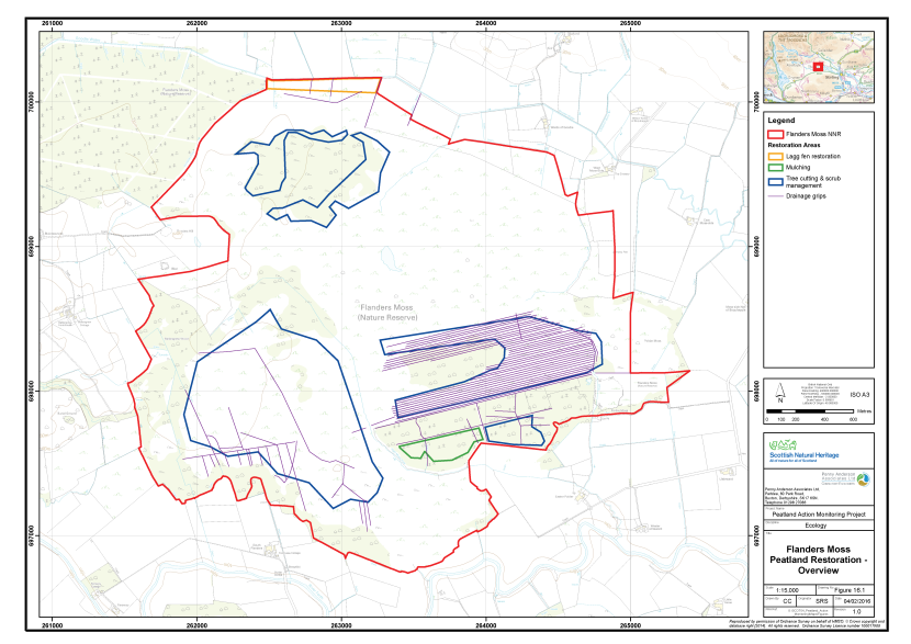
Figure 41. Overview of the peatland restoration conducted at Flanders Moss
Click for a full description
The boundary of the Flanders Moss National Nature Reserve is delineated in red on an OS basemap. Polygons show discrete areas where restoration or management has taken place:
- Lagg fen restoration, in orange
- Mulching, in green
- Tree cutting and scrub management, in blue
- Drainage grips are shown in purple.
Monitoring strategy
The sampling strategy was designed to monitor the change in vegetation after the various restoration measures had been applied to the blanket bog habitat. Samples were taken equally across the four separate treatment types. Each sample plot was allocated an Area code (A, B, C and D, respectively). The sampling took place prior to management being applied, therefore providing a good baseline for future monitoring.
The sampling strategy excluded the central area of the site where birch removal was also completed as this was very similar to the monitoring being undertaken elsewhere on the site (Area A). The sample plots are outlined below:
- Area A - Birch removal;
- Area B - Birch and heather removal;
- Area C – Mulching; and
- Area D - Pine removal.
In each Area, a total of 15 2mx2m quadrats were collected across a homogenous stand of the main vegetation type within the treated area. Quadrats were sampled randomly within the homogeneous vegetation stand. The abundances of all plant species were recorded as percent cover. A number of environmental and vegetation community measurements were also taken, including cover of bare peat, vegetation height and presence of dung (see Annex I for further details).
In addition, the length of the drain between two blocks was sampled at three separate locations within each of Area A (birch scrub removal), Area B (birch and heather removal) and Area C (mulching), again selecting typical examples of the restoration approach. The sample points were marked with a small wooden stake to enable relocation in the future.
The quadrat sample set (60 quadrats across Area A, B, C and D) allows for robust statistical analysis of vegetation community change over time. The samples taken between the ditch blocks (9 sample points across Areas A, B and C) can be assessed individually over time as changes in the area of different components of the vegetation community, or grouped together to identify responses on different parts of the site.
Fixed point photographs were completed to supplement the monitoring datasets.
Baseline survey results
Table 17 presents a summary of the plant species recorded in each of the four sample areas along with their abundance (DAFOR scale). Quadrat data are presented in Annex II and their locations area shown on Figure 42. The fixed point photographs are presented within Annex III and their locations shown on Figure 443. Each sample area is described below.
Table 17. Abundance of plants recorded in the sample plots, Flanders Moss, 2014
|
Common Name |
Scientific Name |
Area A |
Area B |
Area C |
Area D |
|---|---|---|---|---|---|
|
Bilberry |
Vaccinium myrtillus |
- |
- |
R |
- |
|
Bog-rosemary |
Andromeda polifolia |
- |
- |
- |
F |
|
Buckler-fern species |
Dryopteris sp. |
- |
- |
R |
- |
|
Common cottongrass |
Eriophorum angustifolium |
F |
O-R |
O |
- |
|
Cranberry |
Vaccinium oxycoccos |
O |
LF-O |
O |
- |
|
Cross-leaved heath |
Erica tetralix |
O |
F |
O |
- |
|
Crowberry |
Empetrum nigrum |
- |
- |
- |
O |
|
Downy birch |
Betula pubescens |
F |
F |
- |
- |
|
Hare's-tail cottongrass |
Eriophorum vaginatum |
A |
F-A |
D |
D |
|
Heather |
Calluna vulgaris |
F |
F-A |
F |
D |
|
Purple moor-grass |
Molinia caerulea |
- |
F-O |
O-LF |
- |
|
Round-leaved sundew |
Drosera rotundifolia |
O |
- |
- |
R |
|
Rowan |
Sorbus aucuparia |
- |
- |
R |
- |
|
Scots pine |
Pinus sylvestris |
- |
- |
- |
O-F |
|
Silver birch |
Betula pendula |
- |
F |
F |
F |
|
Sitka spruce |
Picea sitchensis |
- |
- |
F |
- |
|
Soft-rush |
Juncus effusus |
- |
- |
R |
- |
|
Spruce sp. |
Picea sp. |
- |
O |
- |
- |
|
Wavy hair-grass |
Deschampsia flexuosa |
O |
- |
F |
F |
|
A bog moss |
Sphagnum capillifolium |
F |
- |
O |
O-F |
|
A bog moss |
Sphagnum capillifolium ssp. capillifolium |
- |
- |
- |
F-A |
|
A bog moss |
Sphagnum capillifolium ssp. rubellum |
- |
F |
- |
F-A |
|
A bog moss |
Sphagnum cuspidatum |
A |
- |
- |
- |
|
A bog moss |
Sphagnum fallax |
- |
F |
A-D |
- |
|
A bog moss |
Sphagnum fimbriatum |
- |
R |
- |
- |
|
A bog moss |
Sphagnum fuscum |
- |
- |
- |
R |
|
A bog moss |
Sphagnum magellanicum |
F |
F |
O |
F |
|
A bog moss |
Sphagnum papillosum |
F |
- |
O |
R |
|
A bog moss |
Sphagnum subnitens |
- |
R |
O |
- |
|
A lichen |
Cladonia sp. |
- |
- |
F |
F |
|
A moss |
Aulacomnium palustre |
- |
- |
- |
R |
|
A moss |
Dicranella heteromalla |
- |
- |
O |
- |
|
A moss |
Dicranum scoparium |
- |
- |
O |
- |
|
A moss |
Hypnum jutlandicum |
O |
- |
- |
- |
|
A moss |
Pleurozium schreberi |
- |
LF-A |
A |
O-LD |
|
A moss |
Polytrichum commune |
- |
O |
- |
- |
|
A moss |
Polytrichum strictum |
O |
O |
F |
R-O |
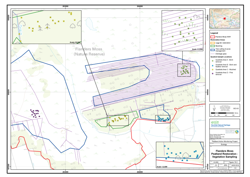
Figure 42. The vegetation survey quadrat locations at Flanders Moss
Click for a full description
A section of the Flanders Moss National Nature Reserve is delineated in red on an OS basemap.
Polygons show discrete areas where restoration or management has taken place:
- Mulching, in green
- Tree cutting and scrub management, in blue
- Drainage grips are shown in purple.
The locations of four clusters of vegetation survey quadrats are shown as numbered squares:
- Area A – birch removal, in green
- Area B – birch and heather removal, in blue
- Area C – Mulching, in yellow
- Area D – pine tree removal, in purple.
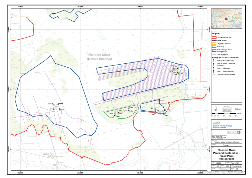
Figure 43. The locations of fixed point photography at Flanders Moss
Click for a full description
A section of the Flanders Moss National Nature Reserve is delineated in red on an OS basemap.
Polygons show discrete areas where restoration or management has taken place:
- Mulching, in green
- Tree cutting and scrub management, in blue
- Drainage grips are shown in purple.
The locations of four clusters of fixed point photography points are shown as filled circles with arrows indicating the direction the photographer faced.
- Area A – birch removal, in green
- Area B – birch and heather removal, in blue
- Area C – Mulching, in yellow
- Area D – pine tree removal, in purple.
Area A - Birch removal
This area of the site was very closely drained with grips approximately every 10m, which may reflect former preparation for plantation forestry or drainage in the 1980s prior to the intended commercial peat cutting, which did not occur (see Figure 41). The habitat adjacent to the drains was generally very wet with Sphagnum cuspidatum and Sphagnum magellanicum, but drier further away from the drain. These drier areas have been colonised by birch, along with more typical bog vegetation comprising hare’s-tail cottongrass, heather ad cross-leaved heath with Sphagnum.
The vegetation is considered to be most similar to M18a Erica tetralix – Sphagnum papillosum raised mire, Sphagnum magellanicum - Andromeda polifolia sub-community (Rodwell 1991). A total of 15 quadrats were taken within this vegetation type, along with seven fixed point photographs to illustrate the general sample area and the sample areas behind the dams within the drains.
Area B - Birch and heather removal
This sample area comprised dense birch scrub approximately 2m in height with an uneven ‘ridge and furrow’ surface, which reflects former use as plantation forestry The plantation was known to be still in place in 1992 and removed sometime thereafter (SNH 2008). The ridges are drier with heather and an accompanying bryophyte flora typical of drier peatland sites with frequent Pleurozium schreberi, Polytrichum strictum and Aulacomnium palustre. The lower wetter ground has abundant Sphagnum magellanicum and S. capillifolium with locally frequent cranberry. Some minor poaching damage to the peat surface was noted from local deer populations.
Large drainage ditches run along two sides of this sample area and they have been blocked in places with plastic piling dams. There is a good accumulation of Sphagnum behind the dams although the water is deep (1m or greater) indicating only aquatic Sphagnum species likely to colonise. The water is overtopping the dams in places.
The vegetation is considered to be most similar to a modified M18a Erica tetralix – Sphagnum papillosum raised mire, Sphagnum magellanicum - Andromeda polifolia sub-community (Rodwell 1991) with dense birch cover and a greater cover of vascular plants than typical for the community reflecting the past land use. A total of 15 quadrats were taken within this vegetation type, along with six fixed point photographs to illustrate the general sample area and the sample areas behind the dams within the drains.
Area C - Mulching
Similar to Area B, this area was a former plantation and known to be under forestry in 1992 (SNH 2008). The trees have been removed some time after 1992 (stumps are visible but rotted) however, the ‘ridge and furrow’ landform still remains. The drier ridges have frequent birch and Sitka spruce (to 4m tall) colonisation within a drier matrix of hare’s-tail cottongrass with frequent heather and wavy hair-grass along with occasional cross-leaved heath and cranberry. The associated bryophyte flora is typical of drier peatland sites with Pleurozium schreberi, Polytrichum strictum and Dicranum scoparium. In the wetter areas Sphagnum species are abundant with Sphagnum fallax being most abundant alongside occasional S. magellanicum, S. papillosum, S. subnitens and S. capillifolium.
The area appears slightly drier overall to the east, were soft rush is locally dominant. The sample area has no internal artificial drainage but large ditches occur around the periphery, again having being blocked with plastic piling dams (as for Area B).
The vegetation is considered to be most similar to a modified M18a Erica tetralix – Sphagnum papillosum raised mire, Sphagnum magellanicum - Andromeda polifolia sub-community (Rodwell 1991) with notable birch and Sitka spruce colonisation and a greater cover of vascular plants than typical for the community, reflecting the past land use. A total of 15 quadrats were taken within this vegetation type, along with six fixed point photographs to illustrate the general sample area and the sample areas behind the dams within the drains.
Area D - Pine tree removal
This large South Flanders area is planned for Scot’s pine and birch tree/sapling removal or to kill and leave larger trees as standing dead wood (to remove seed source). Information provided by the Site Manager, along with the field survey data, indicates the trees are scattered and many are self-seeded across the sample area (rather than being dense plantation-type growth) although the central area of this South Flanders area appears to have been more densely tree covered in 1992 (SNH 2008). The stumps of larger Scot’s pine trees removed some years ago are still visible on the site, although they are rotting down into the bog and becoming covered by the vegetation.
The habitat is generally hummocks with wetter hollows, with heather being the most abundant plant on the higher drier hummocks along with abundant hare’s-tail cottongrass and frequent wavy hair-grass. Birch saplings and seedlings are noted as frequent while Scots pine as canopy; sapling and seedling ages are noted as occasional to frequent across the site. The wetter Sphagnum areas have frequent Sphagnum capillifolium, S. magellanicum and more rarely S. papillosum and S. fuscum. Bog-rosemary is also frequently found.
The vegetation is considered to be most similar to M18a Erica tetralix – Sphagnum papillosum raised mire, Sphagnum magellanicum - Andromeda polifolia sub-community (Rodwell 1991) although modified with a greater cover of vascular plants and with scattered self-seeded birch and Scot’s pine. A total of 15 quadrats were taken within this vegetation type along with four fixed point photographs to illustrate the general sample area.
Constraints on survey
There were no significant constraints noted for the survey. Please note that deer ticks are abundant on this site.
Access to the site is on foot from the site car-park located off the B822. Sample plot A is accessed from the boardwalks in front of the viewing tower, north-east of the car park. Deep flooded ditches made it impossible to Access to Areas B and C from here. Instead, it was necessary to head west from the car-park and enter the site through a gate adjacent to an area of rough grassland. The northern edge of the mature woodland established on the rand of the bog was then followed to Area B. Area C can be accessed directly from Area B, by climbing over a fence. Area D was accessed by crossing High Moss Pow, south of Area C. The western moss was then traversed to Area D. From the car-park to Area D takes approximately 45mins, due to the rough nature of the ground and dense vegetation.
Assessment of restoration approach
The dataset provides a suitable pre-restoration baseline for a range of the key restoration measures being implemented across the site, providing a robust dataset against which future monitoring can be assessed. The evaluation of future monitoring results will need to take into account any recent past and on-going management interventions on the site (such as ditch blocking) as the effects of these measures may still be being observed in the vegetation response within the sample areas. There are, however, extensive records of the management on the site which should aid this.
The vegetation on Areas A (birch scrub clearance), B (birch and heather removal) and C (mulching) should show good responses to the restoration measures, in particular the more innovative measures applied to Areas B and C. On Area D, where scattered trees and saplings are to be removed, the response of the vegetation may be slow as the intervention is minimal and the ground surface will remain largely intact. Changes in the balance of plant species may only be observed very slowly. On vegetation such as Area D the management intervention is used largely to prevent future degradation as opposed to the restoration of already degraded bog, therefore slow change but in a positive direction is typical of these sites.
Overall, there were no issues raised by the survey which indicated potential future problems with the interventions. Peat surface damage from poaching by local deer was noted in Area C but this appeared to be localised.
In terms of future monitoring, monitoring in the year immediately after the application of the restoration measures would be useful, particularly in Areas B and C were the effects of the relatively novel techniques of heather clearance and mulching on lowland raised bogs are relatively poorly understood. Thereafter monitoring every two years would be sufficient, possibly extending to every three years for Area A (birch clearance). Monitoring frequency in Area D (pine clearance) could be lengthened to every four or five years to reflect the slow pace of change in this area of the site.
If the lagg fen restoration works is funded, then a pre-works baseline and regular monitoring is highly recommended at this site as detailed monitoring of the restoration of these types of features on lowland raised bogs is scarce and would make a valuable contribution the knowledge base on these habitats. A similar monitoring approach is likely to be suitable, with 15 2m x 2m quadrats within the area of vegetation affected by the breach in the dam wall. Additional water chemistry monitoring may also be useful to identify the quality of the water flooding in from Goodie Water, as this waterbody is considered to have ‘bad’ ecological status although not related to physico-chemical measurements (SEPA 2011), which may affect the development of the proposed lagg fen vegetation.
Moine Mhor
Overview of the site
Moine Mhor is a large SSSI covering over 1,170ha and includes upland oak woodland and saltmarsh, along with the peatland notified feature which is estuarine raised bog. The estuarine raised bog is an uncommon feature where peat has developed over former estuarine clay deposits (South Moss) and a raised beach feature (North Moss). The site is part of the larger Moine Mhor SAC where both active raised bog and degraded raised bog (capable of natural regeneration) are listed as qualifying interests. The raised bog features are also designated as an NNR (502ha).
Nine species of Sphagnum are listed as occurring on site in the SSSI notification, including the relatively scarce Sphagnum magellanicum. In addition, plants characteristic of raised bog habitat are present including bog asphodel, cranberry and the locally scarce small cranberry (Vaccinium microcarpum) along with deergrass, purple moor-grass, bog myrtle, cross-leaved heath and heather.
The site was drained approximately 200 years ago and in addition some of the peat deposits have been removed to expose the more fertile clay deposits below (largely on the western sections of the site). Planted conifers and invading birch scrub are also thought to contribute to the drying out and degradation of the site. The aim of current management and restoration action is to restore the bog hydrology so that water levels remain at or close to the peat surface (SNH 2010c). The following detail is summarised from the Site Management Statement (SNH 2011d).
Small-scale summer grazing, peat cutting and marginal drainage have taken place on the Moss for over 250 years with more intensive reclamation of the site from the 18th century. From 1750 to 1850 there was large-scale land reclamation where drains were cut through the centre of the bog, farmsteads and roads were constructed, peat cutting increased and grazing intensified. Since 1850 cattle and sheep have grazed much of the bog. The bog and saltmarsh were burned to improve grouse numbers for shooting. At Barnakill the edges of the bog were mown for bog hay and in 1901 The British Charcoal Company produced peat-coke. An accidental fire burned the whole of the North Moss in 1946.
In 1980 about 100ha of conifers were planted outside of the SSSI west of the Kilmartin Burn and as shelterbelts on North Moss. This forestry plantation has been planted on peatland contiguous with the SSSI and forms part of the same hydrological unit, and appears to have dried out part of the bog.
From 1980 to 1987, 501ha of North and South Bog that were proposed for conifer plantation were purchased by the Nature Conservancy Council (now NatureScot). About half the SSSI is now owned by NatureScot and actively managed as a National Nature Reserve (NNR) with nature conservation as the primary objective. Major restorative projects include the blocking of all internal drains with timber and plastic piling dams and removal of trees and scrub. Boundary ditches isolate the reserve from the adjoining agricultural fields, which are intensively managed. Mire conditions are being restored on two of the three NatureScot owned fields (outwith SSSI) at Barnakill. Most of the SSSI outwith the NNR is managed for agriculture.
Existing monitoring on site
There has been some hydrological monitoring on the site in previous years as reported in the 2010 – 2016 Reserve Plan (SNH 2009b).
In 1999 Water Level Range Gauges (WaLRaGs) were installed along two transects on the North and South mosses. These measure the maximum, minimum and current height of the water table in the peat, both in the vicinity of dammed drains and between drains. Monitoring indicated that the damming programme has been successful in raising and maintaining water levels in the vicinity of the drains (Soulsby et al. 2001, Soulsby & McMullen 2003). Minimum water levels could still drop to 40 cm below the surface in parts of the South Moss and at the bottom end of a major drain on the North Moss.
It is understood that readings from the WALRaG transects are still taken in early April, early July and early October to monitor long-term changes in water levels, particularly in the more degraded parts of the South Moss. A rain gauge was installed on the North Moss in 1999 and again readings continue here to allow correlation with the WALRaG monitoring.
Restoration measures undertaken
The Reserve Plan 2010 – 2016 (SNH 2009b) identifies that since 1987 an extensive programme of ditch damming has been completed, with over 150 large-scale timber and plastic piling dams being constructed, blocking all internal drains on the North and South mosses. Monitoring of the water table levels is reported to show a higher water table in the vicinity of all blocked drains. Away from the drains, water levels remain relatively stable over much of the Reserve, particularly the North Moss and central parts of the South Moss. Sphagnum is reported to be regenerating well in the flooded drains and hollows and some dams are now disappearing under the Sphagnum carpet as the drains infill with bog vegetation.
The current phase of restoration measures undertaken under the Peatland Action programme, therefore, moves away from drain blocking towards habitat management focused actions, and comprised (Figure 44):
- Grazing and burning experimental plots comprising combinations of sheep or cattle grazing with and without burning on part of South Moss (15.12ha);
- On-going scrub clearance across South and North Mosses (274ha); and
- Mulching of former forestry plantation area (tree removed approximately 20 years ago) on North Moss to re-profile the peat surface, levelling the ridge material into the furrows, and help raise water levels (5ha).
On the grazing and burning plots there are a few points to note about the set up and the grazing regime. The sheep are free to move between burnt and unburnt areas (Plots A and B) as there is no fencing separating these plots. Similarly the cattle can move freely between burnt and unburnt areas on Plots C and D. The stock were not shut in on the plots over 2013, but could access adjacent grazing. The cattle are never shut in, but the sheep are typically shut in on the plots from the end of March for the summer (2013 being slightly different).
The grazing regime for the plots for 2013 was mid May- early October 2013, with the detail as follows:
Sheep Compartment Plots A and B (not shut in the same arrangement as for the cattle). Equates to approximately 250 sheep days, with access to the adjoining field where they spent most of their time:
- 70 ewes plus lambs (120) access for the first half of June then early August to early September.
Cattle Compartment Plots C and D (equates to approximately 60 cattle days):
- 11 stirks access from mid May - mid June;
- 13 cows and calves access from mid July for 2 weeks; and
- 11 stirks access from mid August - mid September.
At the time of the survey all restoration measures had been applied.
Monitoring of the restoration measures took place between 5th and 6th August 2014 by Alistair Blackshaw (Senior Ecologist, MCIEEM) and Anne Goodenough (Ecologist, MCIEEM).
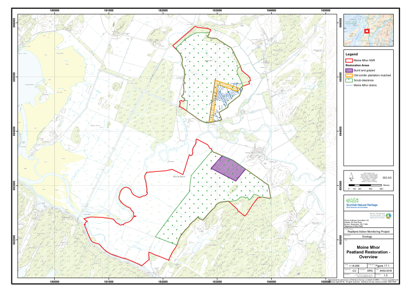
Figure 44. Overview of the peatland restoration conducted at Moine Mhor National Nature Reserve
Click for a full description
The National Nature Reserve at Moine Mhor is delineated as two red polygons on an OS basemap.
Polygons show the areas where restoration or management has taken place:
- A burnt and grazed area is shown with a purple hashed polygon
- An old mulched plantation is shown with an orange hashed polygon
- Areas of scrub clearance are shown with green pattern dot polygons
- Drains are shown as blue lines.
Monitoring strategy
The sampling strategy was designed to monitor the change in vegetation following the application of the three main restoration actions. Under the grazing and burning treatment plots, six separate areas were monitored and allocated an area code (A to F). The treatments applied were as follows:
- Area A – Burnt and grazed by sheep;
- Area B – Unburnt and grazed by sheep;
- Area C – Burnt and grazed by cattle;
- Area D – Unburnt and grazed by cattle;
- Area E – Burnt and ungrazed; and
- Area F – Unburnt and ungrazed.
Two further areas were also sampled on the North Moss:
- Area G - Clearance of birch scrub; and
- Area H - Mulched former plantation.
In Areas A - F a total of 5 2m x 2m quadrats were sampled. In Areas G and H a total of 15 2m x 2m quadrats were collected. Quadrats were sampled randomly within the homogeneous vegetation stand. The abundances of all plant species were recorded as percent cover. A number of environmental and vegetation community measurements were also taken, including cover of bare peat, vegetation height and presence of dung (see Annex I for further details).
The quadrat sample set (30 quadrats across the burning and grazing plots and 30 quadrats across the scrub clearance and mulched plots) allows for robust statistical analysis of vegetation community change over time and between the three sample areas. Fixed point photographs were completed to supplement the monitoring datasets.
Baseline survey results
Tables 18 and 19 present a summary of the plant species recorded in each of the four sample areas along with their abundance (DAFOR scale). Quadrat data are presented in Annex II and their locations area shown on Figure 45. The fixed point photographs are presented within Annex III and their locations shown on Figure 46. Each sample area is described below.
Table 18. Abundance of plants recorded in experimental plots, Moine Mhor, 2014
|
Common Name |
Scientific Name |
Area A |
Area B |
Area C |
Area D |
Area E |
Area F |
|---|---|---|---|---|---|---|---|
|
Bog myrtle |
Myrica gale |
A |
F |
LF |
F |
- |
LF |
|
Bog-asphodel |
Narthecium ossifragum |
R |
R |
- |
- |
D-R |
- |
|
Broad buckler-fern |
Dryopteris dilatata |
- |
- |
- |
- |
O |
- |
|
Common cottongrass |
Eriophorum angustifolium |
- |
- |
- |
- |
O |
- |
|
Common sedge |
Carex nigra |
- |
- |
- |
- |
R |
- |
|
Common spotted orchid |
Dactylorhiza fuchsii |
- |
R |
- |
- |
- |
- |
|
Cranberry |
Vaccinium oxycoccos |
O |
O |
- |
R |
O |
- |
|
Cross-leaved heath |
Erica tetralix |
F |
F |
F |
F |
O |
- |
|
Crowberry |
Empetrum nigrum |
- |
R |
- |
- |
- |
O |
|
Deergrass |
Trichophorum germanicum |
- |
- |
O |
R |
O |
O-LF |
|
Downy birch |
Betula pubescens |
- |
R |
- |
- |
- |
- |
|
Hare's-tail cottongrass |
Eriophorum vaginatum |
A |
A |
A |
A |
A-F |
F |
|
Heather |
Calluna vulgaris |
F |
F |
F |
O |
O-F |
F |
|
Orchid species |
Orchidaceae sp. |
- |
- |
R |
- |
- |
- |
|
Purple moor-grass |
Molinia caerulea |
- |
O |
F-LA |
A |
A-F |
F-LA |
|
Rhododendron |
Rhododendron ponticum |
- |
- |
|
R |
- |
- |
|
Round-leaved sundew |
Drosera rotundifolia |
R |
- |
R |
R |
- |
- |
|
Spruce species |
Picea sp. |
- |
- |
- |
R |
- |
- |
|
Tormentil |
Potentilla erecta |
R |
R |
O |
- |
R |
- |
|
Wavy hair-grass |
Deschampsia flexuosa |
O |
- |
- |
F |
O |
- |
|
A moss |
Aulacomnium palustre |
- |
- |
- |
- |
O |
- |
|
A moss |
Hypnum jutlandicum |
O |
O |
- |
- |
O |
- |
|
A lichen |
Lichen |
|
|
- |
- |
- |
LF |
|
A moss |
Pleurozium schreberi |
O |
O |
- |
- |
- |
LF |
|
A moss |
Polytrichum sp. |
- |
- |
- |
- |
O |
|
|
A bog moss |
Sphagnum capillifolium |
- |
- |
- |
- |
- |
F-O |
|
A bog moss |
Sphagnum capillifolium ssp. capillifolium |
R |
- |
- |
R |
- |
- |
|
A bog moss |
Sphagnum capillifolium ssp. rubellum |
F |
F |
D-LF |
A |
F |
- |
|
A bog moss |
Sphagnum cuspidatum |
- |
- |
O-R |
R |
- |
- |
|
A bog moss |
Sphagnum fallax |
R |
- |
O |
- |
O |
- |
|
A bog moss |
Sphagnum magellanicum |
F |
F |
R |
R |
F |
F-O |
Table 19. Abundance of plants recorded in the scrub clearance and mulched areas, Moine Mhor, 2014
|
Common name |
Scientific name |
Area A |
Area B |
|---|---|---|---|
|
Bilberry |
Vaccinium myrtillus |
O |
- |
|
Bog myrtle |
Myrica gale |
F |
- |
|
Bog-asphodel |
Narthecium ossifragum |
R |
- |
|
Bulbous rush |
Juncus bulbosus |
- |
R |
|
Common cottongrass |
Eriophorum angustifolium |
O |
- |
|
Cranberry |
Vaccinium oxycoccos |
O |
R-LF |
|
Cross-leaved heath |
Erica tetralix |
F |
- |
|
Downy birch |
Betula pubescens |
O |
- |
|
Great wood-rush |
Luzula sylvatica |
R |
- |
|
Hare's-tail cottongrass |
Eriophorum vaginatum |
A |
F |
|
Heather |
Calluna vulgaris |
A |
F |
|
Jointed rush |
Juncus articulatus |
- |
O |
|
Purple moor-grass |
Molinia caerulea |
- |
R |
|
Rowan |
Sorbus aucuparia |
R |
- |
|
Round-leaved sundew |
Drosera rotundifolia |
- |
R |
|
Soft-rush |
Juncus effusus |
- |
O |
|
Wavy hair-grass |
Deschampsia flexuosa |
O |
O-LF |
|
A moss |
Aulacomnium palustre |
- |
O |
|
A lichen |
Cladonia sp. |
F |
- |
|
A moss |
Hypnum jutlandicum |
F |
- |
|
A moss |
Plagiothecium undulatum |
O |
- |
|
A moss |
Pleurozium schreberi |
O |
- |
|
A moss |
Polytrichum commune |
- |
O-F |
|
A bog moss |
Sphagnum capillifolium ssp. rubellum |
A |
- |
|
A bog moss |
Sphagnum cuspidatum |
R |
- |
|
A bog moss |
Sphagnum fallax |
R |
- |
|
A bog moss |
Sphagnum magellanicum |
F |
- |
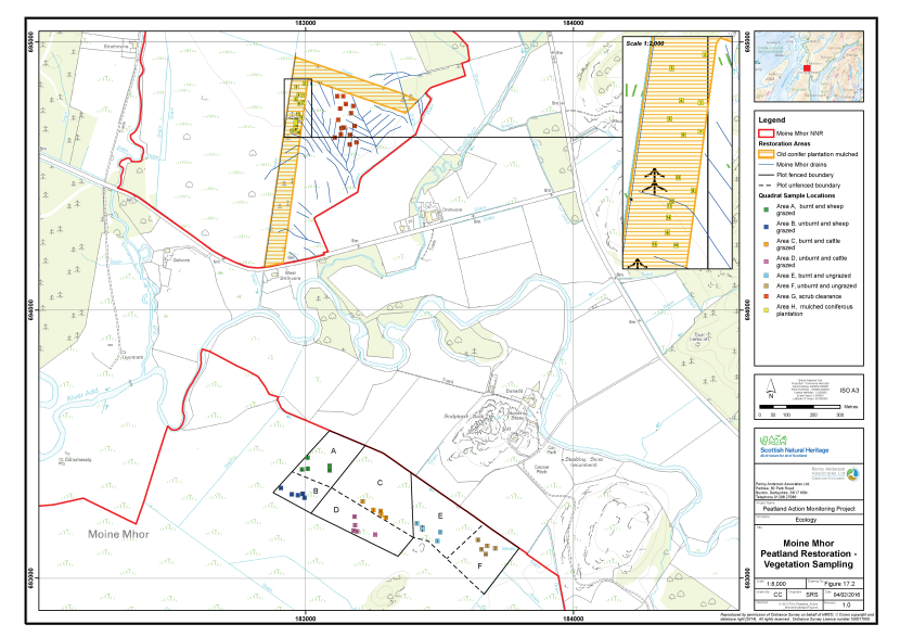
Figure 45. The vegetation survey quadrat locations at Moine Mhor National Nature Reserve
Click for a full description
A section of the National Nature Reserve at Moine Mhor is delineated as two red polygons on an OS basemap.
Polygons show the areas where restoration or management has taken place:
- An old mulched plantation is shown with an orange hashed polygon
- Fence lines between sample areas are show with solid lines. Dashed lines show unfenced boundaries between sample areas.
- Drains are shown as blue lines.
The locations of eight clusters of vegetation survey quadrats are shown as numbered squares:
- Area A – burnt and sheep grazed, in green
- Area B – unburnt and sheep grazed, in blue
- Area C – burnt and cattle grazed, in orange
- Area D – unburnt and cattle grazed, in pink
- Area E – burnt and ungrazed, in light blue
- Area F – unburnt and ungrazed, in brown
- Area G – scrub clearance, in dark orange
- Area H – mulched coniferous plantation, in yellow.
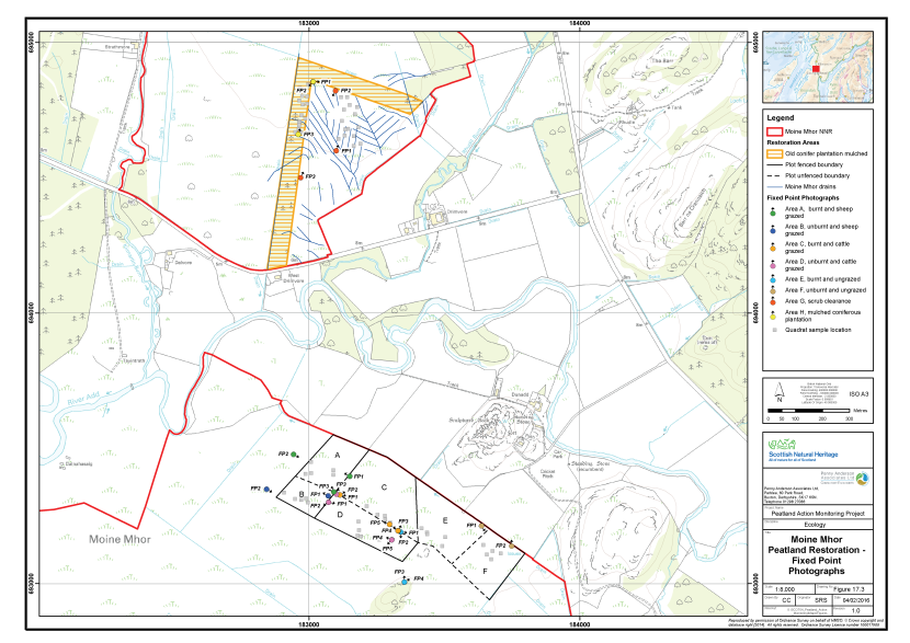
Figure 46. The locations of fixed point photography at Moine Mhor National Nature Reserve
Click for a full description
A section of the National Nature Reserve at Moine Mhor is delineated as two red polygons on an OS basemap.
Polygons show the areas where restoration or management has taken place:
- An old mulched plantation is shown with an orange hashed orange polygon
- Fence lines between sample areas are show with solid lines. Dashed lines show unfenced boundaries between sample areas.
- Drains are shown as blue lines.
The locations of eight clusters of fixed point photography points are shown as filled circles with arrows indicating the direction the photographer faced:
- Area A – burnt and sheep grazed, in green
- Area B – unburnt and sheep grazed, in blue
- Area C – burnt and cattle grazed, in orange
- Area D – unburnt and cattle grazed, in pink
- Area E – burnt and ungrazed, in light blue
- Area F – unburnt and ungrazed, in brown
- Area G – scrub clearance, in dark orange
- Area H – mulched coniferous plantation, in yellow.
Areas A to F - Grazing and burning experimental plots
Plot A was subject to burning and sheep grazing, while Plot B was unburnt but subject to sheep grazing. Plot C was subject to burning and cattle grazing, while Plot D was unburnt but subject to cattle grazing. Plot E was burnt but not grazed. Plot F was the unburnt and ungrazed control.
In terms of vegetation, the plots were similar in their floristics, with only relatively subtle changes due to small-scale variations in wetness. In the main, the vegetation was predominantly a mix of hare’s-tail cottongrass and heather with cross-leaved heath and Sphagnum capillifolium frequent. Bog myrtle was frequent to abundant in all plots except Plot E (burnt and ungrazed) while cross-leaved heath was absent form the control Plot F (unburnt and ungrazed). Sphagnum magellanicum was frequent across the plots, except in the two cattle grazed plots (plots C and D) where it was considered rare. It is not clear if these differences are linked to the treatments as there is no pre-treatment baseline and may be the result of pre-existing variation across the area.
The vegetation is considered to be most similar to modified M18a Erica tetralix – Sphagnum papillosum raised mire, Sphagnum magellanicum - Andromeda polifolia sub-community (Rodwell 1991). A total of 30 quadrats were taken across the experimental plots (five in each plot) along with 24 fixed point photographs.
Area G - Scrub clearance
This area of raised bog had been subject to previous ditch blocking and the ditches now appeared largely in-filled and difficult to distinguish on the ground. The water level was at the surface and the surface was very wet. This area was subject to some on-going scrub clearance, however, the evidence of any stumps or brash remaining on site was not readily seen across the area, indicating the treatment had only needed to be quite light. Scrub (downy birch and rowan) are only occasional to rare across the site although observed to be regenerating.
The vegetation in this area was quite uniform. Hare’s-tail cottongrass had developed as tussocks across the site and was abundant along with heather, while bog-myrtle, cross-leaved heath and Cladonia species were frequent to abundant. Sphagnum species occur across the area within lawns, hummocks and hollows with the main species being Sphagnum capillifolium subspecies rubellum along with frequent S. magellanicum. Sphagnum fallax, and S. cuspidatum were both rare.
The vegetation is considered to be most similar to a modified M18a Erica tetralix – Sphagnum papillosum raised mire, Sphagnum magellanicum - Andromeda polifolia sub-community (Rodwell 1991). A total of 15 quadrats were taken within this vegetation type along with three fixed point photographs.
Area H - Mulched
This area of raised bog had been subject to past removal of plantation (some 20 years ago) and unsuccessful attempts to raise the water table. This current phase on restoration sought to remove the ‘ridge and furrow’ plantation landform to encourage more even re-wetting of the peat surface. The ‘ridge and furrow’ topography was still noticeable in the peat surface, with wetter hollows and drier higher area, but appeared more uniform that normally observed at plantation sites.
The area was dominated by bare peat (20 to 30% on average) following the mulching operation, however, there were signs of recolonisation by common cotton-grass and heather (both frequent) along with occasional Sphagnum capillifolium, Polytrichum commune and Pleurozium schreberi. Polytrichum commune can expand and become dominant to the exclusion of other moss species on some sites where ground disturbance has occurred. This should be carefully monitored as Polytrichum is occasional to frequent across the site. Soft rush and jointed rush (Juncus articulatus) were also noted as occasional and again these species have the ability to expand relatively rapidly across disturbed peat areas, therefore their re-colonisation rate should be closely monitored, and intervention to control their spread may be required.
The vegetation is considered to be a form of degraded M17a Scirpus cespitosus – Eriophorum vaginatum blanket mire, Drosera rotundifolia - Sphagnum species sub-community (Rodwell 1991), although following the recent mulching treatment the vegetation has been highly modified and in particular no deergrass is recorded in 2014. A total of 15 quadrats were taken within this vegetation type along with three fixed point photographs.
Constraints on survey
No significant constraints were noted for the survey.
Assessment of restoration approach
Experimental plots
The plot set up and inclusion of an untreated control at this site provides a good dataset against which future monitoring of the effects of grazing and burning impacts can be assessed. The lack of pre-treatment data will likely mean that the effects of pre-existing minor variation (for example small changes in ground wetness) in vegetation may not be able to be fully explored or clarified; however, over time the effects of the treatments should still be able to be observed.
The main aim of the plot trials was to identify an appropriate management technique to reduce purple moor-grass whilst retaining and enhancing the blanket bog plant species. In general burning on its own can encourage purple moor-grass to increase its dominance (e.g. Ross et al. 2000, 2003; Todd et al. 2000). There is good evidence that summer cattle grazing can aid the control of purple moor-grass (Penny Anderson Associates 2011a, 2011b; Critchley et al. 2013) but in the absence of additional management measures this change can be slow (Fraser et al. 2011).
The evidence on the use of sheep grazing to control purple moor-grass is less clear, with site-specific factors appearing to influence the effectiveness of this approach (Marrs et al. 2004, Todd et al. 2000). Mixed sheep and cattle grazing can, however, have more beneficial results for purple moor-grass management although there can be some trampling impacts on other species (Critchley et al. 2008).
The lack of fencing between the burnt and unburnt plots for both the cattle grazed and sheep grazed plots is allowing stock to graze selectively across the plots, a well documented issue in upland areas (Martin et al. 2013). This is resulting in grazing being focused on only certain areas of the plots, with very little grazing impact across the remainder of the plots. The cattle’s access to additional grazing pasture (and occasional sheep access to adjacent grazing) should also be integrated into any future analysis of monitoring data. All these factors are important to document for future data analysis and interpretation as the monitoring continues, and may make the effects of individual treatments more difficult to separate.
To make the treatments more experimentally robust each grazed plot should be a self-contained unit and consideration to fencing the plots should be given, however, this may not be practicable or desirable on the ground as forcing stock onto wetter area might damage the Sphagnum cover and harm the health of the stock.
Repeating the monitoring in 2016 would be an appropriate timeframe for the plot monitoring.
Scrub clearance and mulched areas
These two treatment areas had no pre-treatment controls, however, the dataset will provide a good point from which to monitor the recovery of these areas from the management interventions.
Scrub encroachment of Area G appeared to have been limited in extent with no significant scrub cover having developed over this area. The treatment is, therefore, best classed as on-going management rather then restoration treatment and is likely to maintain an already high value site rather than afford dramatic changes in the vegetation.
The mulching treatment has had more impact, with the ‘ridge and furrow’ topography that remained from the former plantation use being levelled to aid a more even re-wetting of the peat surface. Previous felling and ditch blocking had re-wetted the site, and it is well documented for other similar sites (Anderson 2010), but the ridges still remained too high for effective re-wetting. The success of levelling these forestry ridges by mulching is not yet well known or documented, therefore continued monitoring of the results of this treatment is highly desirable.
Repeating the monitoring in 2016 would be an appropriate timeframe for these two areas, although priority should be given to monitoring the mulched area above the scrub control area, due to the lack of monitoring data on this technique.
Portmoak Moss
Overview of the site
Portmoak Moss is a 44ha raised bog site with degraded bog vegetation due to past land use (afforestation and drainage of the entire site and peat cutting at the periphery). The site has no statutory designations and is managed by the Woodland Trust and a local community group.
The site has deep peat deposits of up to 6.7m at the dome but the peat depth is much reduced to less then 2m at the edges where peat cutting has occurred (Mouchel 2013). In addition, there is a vertical cut peat face of some 2 to 3m high which significantly disrupts the site’s hydrology. This is further exacerbated by a series of drains and ‘ridge and furrow’ features related to the previous afforestation activities.
The site was bought and drained and planted with conifer plantation by the Forestry Commission in 1960s. In 2000 and 2004/05 the mature trees on the central dome were removed and a number of drains dammed at the same time. Drains close to the vertical cut peat face were not dammed due to the risk of causing slumping of very wet peat under such unstable conditions. Despite the dams and forestry removal the peat surface remained dry and prone to on-going tree colonisation, predominantly self-seeded birch. Scrub clearance was undertaken across much of the main dome on an ad-hoc basis.
Existing monitoring on site
A series of dipwells have been monitored at the main dome of the site by the Woodland Trust and the community group since 2003 and those data up to autumn 2013 have been collated and assessed (Mouchel 2013a). These data indicate a rise in the water levels relative to the bog surface since the dams were installed (2006 onwards), along with some stabilisation of water levels. This report identifies that the water table is on average 183mm below ground surface (bgs), and recommends a level of no more than 100mm bgs for Sphagnum colonisation and expansion.
It is unclear if there is an intention to re-instate a similar programme of dipwell monitoring after mulching operations.
An NVC survey was also completed across the site (Mouchel 2013a) with the main habitats on the peat dome being identified as H12a Calluna vulgaris – Vaccinium myrtillus heath, Calluna vulgaris sub-community and M19a Calluna vulgaris – Eriophorum vaginatum blanket mire, Erica tetralix sub-community. This reflects the dry nature of the site. There is an aim to restore M18 Erica tetralix – Sphagnum papillosum raised mire vegetation across 50% of the site by 2015 and 75% of the site by 2020. There is, however, recognition of the need to review this goal if restoration to raised bog habitat is considered unrealistic after some years.
Restoration measures undertaken
The site was formerly more extensively planted with forestry which has been removed from the main mire expanse in recent decades. In addition, the network of drains on site has been blocked by the installation of a number of plastic piling dams in more recent years. Re-profiling of the vertical cut peat faces to reduce risk of unstable peat collapse following re-wetting was also recommended (Mouchel 2013b), however, this is not included in the current restoration measures.
The current restoration measures comprised the use of a mulching machine to remove any remaining saplings, brash and stumps on site while also flattening out the ‘ridge and furrow’ surface (removing much existing vegetation) and filling in the majority of drains on site.
Mulching operations were carried out over a week in August 2014 and baseline vegetation monitoring was completed after the treatment was applied.
Mulching operations were carried out over a week in August 2014. Monitoring of the restoration measures took place between 9th and 10th September 2014 by Dr Sarah Ross (Associate Director, MCIEEM) and Anne Goodenough (Ecologist MCIEEM).
Monitoring strategy
The sampling strategy was designed to monitor the recolonisation of vegetation after mulching had been undertaken across the site (Figure 47). Samples were taken equally across three separate areas as follows, an area west of the main drain, an area east of the main drain which and an area to the south of the main path. All areas were previously under plantation. Each was allocated an Area code (A, B and C, respectively). The sample plots are outlined below:
- Area A - Mulched area, west of main drain;
- Area B - Mulched area east of main drain; and
- Area C - Mulched area south of main path.
The sampling strategy excluded any areas around the margins of the main bog which are still under plantation/woodland and are likely to remain so for the foreseeable future.
In each area a total of 15 2mx2m quadrats were collected across a homogenous stand of the main vegetation type within the treated area. Quadrats were sampled randomly within the homogeneous vegetation stand. The abundances of all plant species were recorded as percent cover. A number of environmental and vegetation community measurements were also taken, including cover of bare peat, vegetation height and presence of dung (see Annex I for further details).
The quadrat sample set (45 quadrats across Area A, B and C) allows for robust statistical analysis of vegetation community change over time after mulching has been applied. Fixed point photographs were completed to supplement the monitoring datasets.
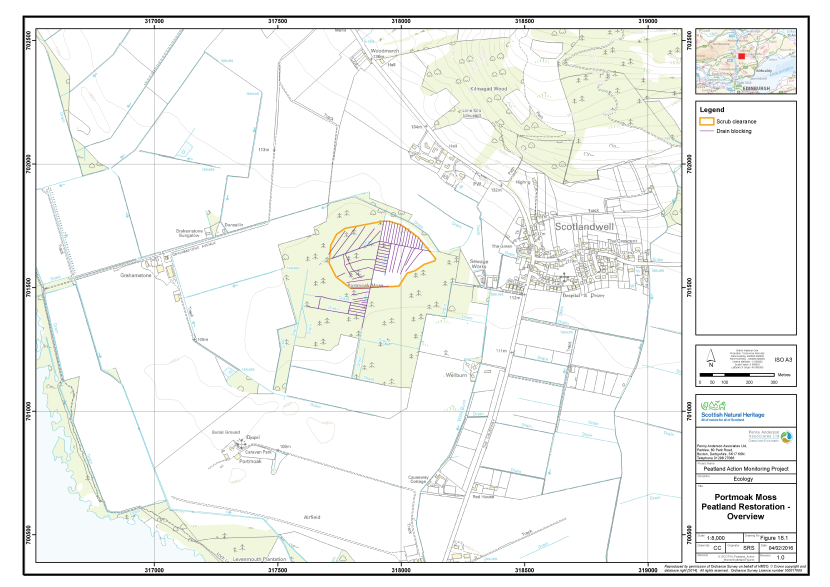
Figure 47. Overview of the peatland restoration conducted at Portmoak Moss
Click for a full description
Portmoak is shown an OS basemap. An orange polygons shows where scrub clearance has taken place, and within this, purple lines show drains that have been blocked.
Baseline survey results
Table 20 presents a summary of the plant species recorded in each of the four sample areas along with their abundance (DAFOR scale). Quadrat data are presented in Annex II and their locations area shown on Figure 48. The fixed point photographs are presented within Annex III and their locations shown on Figure 49. Each sample area is described below.
Table 20. Abundance of plants recorded in the sample plots, Portmoak Moss, 2014
|
Common name |
Scientific name |
Area A |
Area B |
Area C |
|---|---|---|---|---|
|
Bilberry |
Vaccinium myrtillus |
O |
O |
O |
|
Birch species |
Betula sp. |
- |
R |
- |
|
Broad buckler-fern |
Dryopteris dilatata |
R |
- |
R |
|
Downy birch |
Betula pubescens |
- |
- |
O |
|
Hare's-tail cottongrass |
Eriophorum vaginatum |
O |
O |
- |
|
Heather |
Calluna vulgaris |
O-LF |
F |
O-LF |
|
Pine sp. |
Pinus sp. |
- |
R |
R |
|
Rosebay willowherb |
Chamerion angustifolium |
- |
- |
R |
|
Silver birch |
Betula pendula |
- |
- |
O |
|
Spruce sp. |
Picea sp. |
- |
- |
R |
|
Wavy hair-grass |
Deschampsia flexuosa |
O |
F |
O-LF |
|
A bog moss |
Sphagnum capillifolium |
- |
- |
R-O |
|
A bog moss |
Sphagnum capillifolium ssp. capillifolium |
O |
O |
- |
|
A bog moss |
Sphagnum capillifolium ssp. rubellum |
R |
O |
- |
|
A bog moss |
Sphagnum fallax |
O |
- |
- |
|
A bog moss |
Sphagnum fimbriatum |
R |
- |
- |
|
A bog moss |
Sphagnum magellanicum |
R |
- |
R |
|
A bog moss |
Sphagnum papillosum |
- |
R |
R-O |
|
A lichen |
Cladonia pyxidata |
R |
- |
- |
|
A lichen |
Cladonia sp. |
- |
R |
- |
|
A lichen |
Parmelia sp. |
R |
- |
- |
|
A moss |
Aulacomnium palustre |
- |
O |
- |
|
A moss |
Campylopus flexuosus |
- |
R |
O |
|
A moss |
Campylopus introflexus |
- |
- |
O |
|
A moss |
Dicranum scoparium |
- |
R |
O |
|
A moss |
Hylocomium splendens |
R |
- |
- |
|
A moss |
Hypnum jutlandicum |
R |
R |
O |
|
A moss |
Pleurozium schreberi |
O-LF |
O-LF |
O-LF |
|
A moss |
Polytrichum commune |
R |
R |
R |
|
A moss |
Polytrichum juniperinum |
- |
- |
R |
|
A moss |
Polytrichum strictum |
- |
R |
R |
|
Broad buckler-fern |
Dryopteris dilatata |
R |
- |
R |
|
Downy birch |
Betula pubescens |
- |
- |
O |
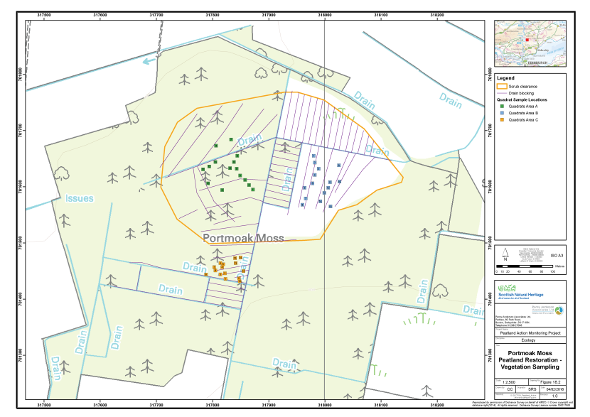
Figure 48. The vegetation survey quadrat locations at Portmoak Moss
Click for a full description
Portmoak is shown an OS basemap. An orange polygon shows where scrub clearance has taken place, and within this, purple lines show drains that have been blocked. Three clusters of numbered squares represent vegetation survey quadrats, with Area A, in green, and Area B, in blue, inside the scrub clearance polygon, and Area C, in orange, outside it.
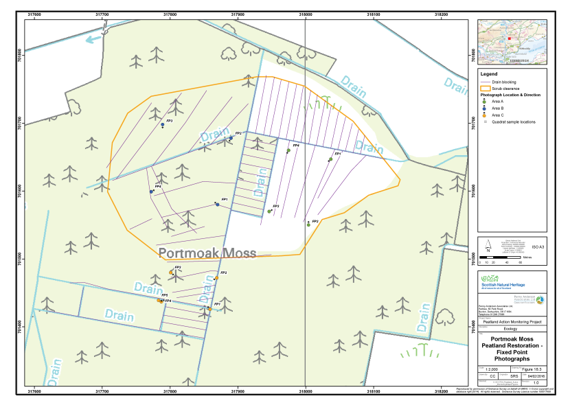
Figure 49. The locations of fixed point photography at Portmoak Moss
Click for a full description
Portmoak is shown an OS basemap.
Drainage grips are shown in purple.
The locations of three clusters of fixed point photography points are shown as filled circles with arrows indicating the direction the photographer faced.
- Area A, in Phase 1 in green
- Area B, in Phase 3 in blue
- Area C, in Phase 4 in orange.
Area A - Mulched area west of main drain
The site had been mulched at the time of the baseline surveys resulting in a highly modified surface and disrupted vegetation community. Conifer plantation stumps were still evident but they were ground down to surface level. All the drainage grips and ridges relating to afforestation had been filled in or flattened down although the plastic piling installed as dams were still evident in some areas allowing the previous line of the drain to be identified. Some areas were not mulched around standing dead trees in order to maintain the tree in situ, however, the surface was littered with mulched debris.
In terms of the resulting vegetation, the site was dominated by the mulched debris and bare peat following mulching. Heather, bilberry, wavy hair-grass and hare’s-tail cottongrass were occasional on the site along with occasional Sphagnum capillifolium (both subspecies), Pleurozium schreberi and Aulacomnium palustre. Other mosses and lichens were found only rarely. Many of the plants remaining on site had been damaged and some additional die-back might be expected, in particular any bryophytes that are damaged and vulnerable to desiccation. That said, some species such as heather and hare’s-tail cottongrass can respond vigorously to cutting and as such may re-grow quickly after the similar effect of mulching.
A total of 15 quadrats were taken within this vegetation type along with four fixed point photographs to illustrate the general sample area.
Area B - Mulched area east of main drain
This site is similar to Area A but has slightly less mulched debris and slightly less bare peat, with more of the vegetation remaining intact. In particular the bryophyte layer has remained relatively undisturbed in places. As for Area A, the drains have been in-filled and are no longer very obvious except for the line of any remaining plastic piling. A larger area of unmulched is retained around some dead trees and this will provide a good seed source for recolonisation onto the local area.
A total of 15 quadrats were taken within this vegetation type along with four fixed point photographs to illustrate the general sample area.
Area C - Mulched area to south of main path
Again, the resulting vegetation after mulching is similar to Areas A and B, being dominated by bare peat and mulched debris. This area is drier that the other two sample areas, being away from the main peat dome, and has only one drain at the southern edge of the site. This drain was previously dammed with plastic and is now in-filled following mulching operations. Much of the vegetation has been ‘scalped’ to remove the ‘ridge and furrow’ formations, but heather and wavy hair-grass are occasional along with frequent bilberry still retained on the site. Few other vascular plants are present. Bryophytes are scarce across the site although fragments are present in all quadrats. The main species remaining being Pleurozium schreberi, Hypnum jutlandicum, Dicranum scoparium and Campylopus species.
As for other areas, a total of 15 quadrats were taken within this vegetation type along with five fixed point photographs to illustrate the general sample area.
Constraints on survey
No constraints were identified during the survey. All areas of the site were accessible and the information provided on previous site management interventions and site history was helpful in developing the monitoring approach.
Parking for the site is on an access road, off The Causeway, just south of Scotlandwell. Access to the site is on foot from the parking and follows surfaced paths.
Assessment of restoration approach
The lack of a detailed pre-treatment survey, along with no suitable control area on such a small site, limits future evaluation, although some reference to the NVC map (Mouchel 2013a) can be made. However, despite the lack of a baseline or control the opportunity to monitor in detail such an innovative and dramatic restoration approach is considered important.
Future monitoring datasets will enable post-treatment re-colonisation of the vegetation to be monitored closely and compared between areas previously under plantation and those previously largely unplanted with forestry. It would be useful to re-survey the site quite quickly after the baseline (perhaps 2015 or 2016) so as to assess the early phases of restoration (for example, will Campylopus colonise bare areas rapidly or will Sphagnum be able to re-establish) to inform any follow-up measures required.
The original survey approach proposed an assessment of the re-colonisation of drains behind a number of plastic dams installed at the site, however, the mulching operation resulted in the majority of these drains being filled in with peat and debris. As such no grip block monitoring could be completed at this site although a number of fixed point photographs include the former grips enabling some assessment of their change over time. Some assessment of how these in-filled drains respond (do they slump and form wet hollows and a focus for Sphagnum growth or do they remain drier and become obscured over time) would be informative.
The site was formerly a slightly larger raised bog but the edges have been degraded by agricultural and forestry operations. In addition there is a history of peat cutting. The site’s edges have been degraded and there are a number of vertical peat faces that almost constantly appear to ‘weep’ water from the site. Whilst the former grip blocking, scrub control and possibly the mulching operations will improve the wetness of the site, it is likely that the site will not support the development of very wet bog vegetation due to its highly modified hydrology and isolated nature (Bragg 1995, Schouwenaars 1995, Baird 2008) but instead a mix of wet and dry heath vegetation communities with smaller pockets of bog where water can pool. This would still provide a valuable habitat and support a number of important ombrotrophic plant species including bog-mosses.
Re-profiling has been recommended in the past as a means to maintain the stability of the peat body as it re-wets. This recommendation should be kept under review, but as it would comprise a significant amount of ground disturbance it should only be considered if the site appears to be re-wetting in a significant manner. If the final aim is to maintain a slightly drier mix of dry and wet heath vegetation with pockets of wetter bog, then re-profiling may not be necessary.
The re-instatement of dipwell monitoring on the main peat dome, in line with the previous scheme, would be a useful supplement to the monitoring programme.
Overview of treatments
Blanket bogs
Drain blocking
Drains within four of the blanket bog sites surveyed had been blocked with dams prior to survey. These were Airds Moss, Drumrunie, Edinglassie and Glenmullie. Conventional drain blocking was also proposed for a further two sites, Arran and Dunruchan farm in winter 2015/16, but work had not been completed by the time they were surveyed. Drain blocking through the total infilling of the grips was also proposed for Luss but had not commenced prior to the survey. Some occasional gully blocks had been constructed at Edinglassie and Dundreggan, but these were scattered and therefore not suitable for formal sampling.
There is considerable evidence that blocking of grips raises water tables and increases the time which the water table is close to the bog surface, however, water levels in blocked areas may not return to those of undrained peatlands (Wallage and Holden 2011, Holden et al. 2011, Bellamy et al. 2012). Shepherd et al. (2013) found less strong evidence that drain blocking increased populations of wetland plants, however, these effects are widely reported and rarely refuted. High and stable water tables is one of the key factors often cited for the successful recolonisation of Sphagnum on peatlands, however Carroll (2009) completed a review of the conditions for Sphagnum growth and identified that high precipitation levels may preclude this requirement by constant replenishment of the water table through infiltration.
Burtt and Hawke (2008) assessed the use of a number of different techniques for blocking drains and identified plastic sheet piling as being the most effective, resulting in peat deposition and re-vegetation in the pools behind the blocks. However Shepherd et al. (2013) determined that peat dams are comparable or better than more expensive solutions (such as plastic).
The peat dams installed at Drumrunie and Edinglassie were found to be functioning well in general. The majority of drains which held water at the time of the surveys in September and July, respectively, were filled close to the tops of their banks. The surveys of these sites were carried out too soon after damming for colonisation of the pools behind the dams by Sphagnum moss to be recorded. As might be expected with a large number of dams constructed on both sites, some dams were being eroded by water flowing around them. At Edinglassie, several potential erosion zones were noted adjacent to the drains, where depressions resulting from turves stripped for patching the compressed edges of the drains lay very close together.
The peat dams at Glenmullie were generally functioning well and have successfully reduced flow in the drains. Although the dams had slowed water flow, few retained water to the level of the top of the drain. This effect was particularly notable in the eastern part of the site, where peat dams had been placed directly onto less than 0.2m of peat or mineral ground. This had caused under-cutting of the dams, which may eventually wash-out. Water flow over and around a number of dams was also observed and had lead to erosion in some cases. This process may also lead to eventual wash-out. The survey was carried out too soon after damming for colonisation of the pools behind the dams by Sphagnum moss to be recorded.
The peat dams at Airds Moss were generally functioning well. The pools behind some of the dams which had been completed in 2010 were undergoing transition to more terrestrial vegetation, with hare’s tail cottongrass and, in places, purple moor-grass beginning to colonise into the lawns of Sphagnum dominated vegetation. The pools behind the dams completed in 2012 comprised definite Sphagnum hollows (Lindsay 2010), with little terrestrial vegetation. The pools behind the dams completed in 2014 have much more open water and the deepest were just beginning to be colonised by Sphagnum cuspidatum. The dataset collected from the pools demonstrates a sequence of territorialisation consistent with the nanotopes described by Lindsay (2012) and suggests, at Airds Moss newly excavated pools are likely to become akin to terrestrial bog nanotopes in four to five years due to infill of vegetation.
Blocking of the drains at all sites is considered likely to show positive results through raised and stabilised water levels, reduced erosion damage within the drains and colonisation of pools of water by a range of aquatic species. The treatment is also likely to result in raised water tables in the areas adjacent to the drains which should facilitate the spread of Sphagnum species within the sites.
The effect of blocking on blanket bog vegetation quality may be more significant at Drumrunie and Edinglassie than at Glenmullie. The drains at Drumrunie and Edinglassie former sites are closer together than at Drumrunie and the baseline state of the vegetation is more typical of blanket bog, thus providing greater potential for re-wetting and a more advanced starting point for recovery. At Glenmullie, the drains are more than 100m apart; being only 1.5m wide the effect of blocking is unlikely to be detectable over such a wide area. Peat depth is also relatively shallow across the southern part of the site, being generally less than 1.0m. It is likely that, together with the slope of the site, this may be a limiting factor on the quality of the vegetation that might be achievable at Glenmullie in the long-term.
The long-term trajectory of vegetation within the blocked areas at Airds Moss is less clear. Purple moor-grass still appeared to be dominant in all the restoration Phases despite some drains having been blocked for approximately four years by the time of the survey. A basic analysis of the vegetation data for the three Phases suggests there might be a trend towards decreasing abundance of purple moor-grass, increasing abundance and frequency of hare’s-tail cottongrass and Sphagnum capillifolium sensu lato with time since blocking. Unfortunately, a lack of baseline data for the later Phases renders it impossible to judge whether this is a real trend or simply due to inherent differences in the vegetation.
Infilling of grips is proposed for gripped areas with a gradient of more than 8 degrees at the Luss Estate restoration site. The method would be to infill 30m sections of the grips with peat excavated from the adjacent intact bog. This strategy is, however, considered quite high risk due the need to ‘borrow’ all of the infill peat required. Infilling requires a greater volume of peat than the volume of the grip. Excavation of the infill material has the potential to result in the development of drainage lines adjacent to the existing grips, which are likely to erode quickly, particularly on steeper slopes.
A less risky solution than infilling would be use another method of dam construction (e.g. plastic or timber) that incorporated a spillway to allow excess water to escape down the channel mitigating against the build-up of a head of pressure which could cause a breach. On steeper slopes, dams could be more closely spaced and incorporate a splash plate (e.g. a heather bale) to absorb the energy of water issuing from the spillway of the dam above and thus prevent scour downstream.
It is recommended that condition of the dams at all sites is monitored regularly and remedial action taken to prevent washing-out if necessary.
Re-profiling and turfing
Re-profiling and turfing of hagg and gully slopes had been carried out at three sites; Edinglassie, Glen Ey and Glenmullie. A similar treatment was proposed for a further two sites; Arran and Luss Estate. The re-profiling and turfing treatment was intended primarily to halt the erosion of peat from the bare faces and also to provide a buffer against deeper drying of the peat behind, which generally supported bog vegetation at the treated sites.
As the same contractor had carried out the work the method was generally the same at all treated sites. Firstly, salvageable vegetation was removed from the slope and laid to one side. The slope was then re-profiled to 45° or less and the original turf laid on top of the new surface. At all sites, salvaged turf was supplemented by turf stripped from adjacent areas. On some slopes turf completely covered the slope (e.g. Edinglassie, Area A) in others mulch (see below) was added to provide vegetation cover to remaining bare areas (e.g. Glen Ey, Area B).
Initial observations of the treated areas were positive at all sites, suggesting that the turves were in good condition following translocation and had remained where they had been placed by the excavator. The treatment will only successfully fulfil its aims in the long-term, however, if the root systems of turves can coalesce with the peat on to which they were placed. Provided the turf remains in place, the majority of re-profiled and turved slopes are unlikely to develop into good quality blanket bog vegetation because of their sloping and therefore relatively well drained peat. This is not considered to be a major limitation of the treatment as its primary aim was to prevent further erosion of peat.
Re-profiling has been used in many peatland restoration projects, however, the effectiveness of the treatment, combination with turfing, in establishing lasting vegetation cover on peat haggs and gully sides has not been subject to much scientific review. Given the lack of published studies, sites monitored under the Peatland Action programme present the ideal opportunity to collect useful data. It will therefore be important to closely monitor the outcome of the treatment across the three sites where it has been implemented and the three additional sites where it was proposed. It is recommended that site walkovers are undertaken at Arran, Edinglassie, Glen Ey, Glenmullie and Luss Estate in 2016 to provide a preliminary assessment of success of re-profiling and turfing.
Mulching
A mulch of locally harvested vegetation had been applied to bare peat at two sites; Edinglassie and Glenmullie. It was scheduled to be applied to a third site, Glen Ey, during the week after it was surveyed. The aim of the treatment was to act as a source of propagules to promote colonisation of bare peat by vegetation. As it was harvested locally, the composition of the mulch varied between the sites. The exact composition of the mulches could not be accurately assessed, however, at Edinglassie, it appeared to contain a high proportion of pleurocarpous mosses and Sphagnum, together with cottongrasses and a small amount of heather. At Glenmullie, the majority of the mulch comprised building phase heather together with Sphagnum.
Evidence from the two treated sites showed that establishment of vegetation fragments from the mulch was sparse. The reasons for this were considered to be two fold; firstly, the treated areas were likely to have had significantly lower water tables than typically found in intact blanket peat because they comprised unvegetated thin, sloping peat, usually at the edge of a hydrologically degraded peat body. Natural England’s review of bog restoration (Shepherd et al. 2013) found on that regeneration of Sphagnum added as mulch is only likely to be successful where water tables are high. Although this may explain the low regeneration rate of moss fragments, it doesn’t explain why little successful heather regeneration was observed.
Secondly, it appeared that there had been significant redistribution of the mulch at both treated sites during the six to eight months since it was applied. This is supported by comparison of the photographs taken immediately post-treatment at Glenmullie with those taken as part of this survey. This effect was also apparent at Edinglassie, with sorting of mulch fragments along flow lines and at the edges of ephemeral pools evident (see Annex III), although no immediately post-treatment photographs were available to be cross-referenced.
Establishment of vegetation on bare peat is dependent on whether the propagules remain in contact with the peat long enough to establish on its surface. Water flow over bare peat is faster than over vegetated peat (Holden et al. 2008) and therefore more erosive. Smaller fragments of establishing vegetation are at greater risk of being swept away by such flows. Furthermore, water can cause erosion of the peat on which vegetation is establishing and surfaces may recede vertically by up to 62mm per year (Shepherd el al. 2013).
At all three sites it was considered likely that wash-out of plant fragments, together with instability in the peat caused by overland flow and direct weathering, have prevented or would be likely to prevent establishment from the mulch, such that a significant area of bare peat is re-vegetated. It was considered that the measures could have been improved by application of the mulch to more stable peat. Stabilisation measures could have included use of geo-jute and coir rolls and heather bales on flat bare areas. It is considered likely that greater use of heather brash and even nursery grass mixes, together with fertiliser, could also have improved success of the treatment.
Although similar ‘mulches’ have been successful in establishing Sphagnum elsewhere (e.g. Campeau and Rochefort 1996; Bugnon et al. 1997; Rochefort et al. 2003); their application without additional stabilisation measures is not widely reported, however, and there is very little information of mulches being used in this way on upland blanket bogs. Shepherd et al. (2013) found no evidence of whether Sphagnum colonisation could occur in degraded blanket bogs with low water tables, but that demonstration of this effect would be useful to inform practical conservation measures. It is, therefore, recommended that the sites treated with mulch are monitored closely. Walkover surveys of all mulched sites in 2016 are recommended, to assess the condition of the treatment. Follow-up monitoring in 2017 is recommended and should determine whether, after initial redistribution, the mulch stabilises and begins to generate plant cover.
Clearance of coniferous trees
Clearance conifers had been undertaken on two sites; Dundreggan and Glenmullie. Clearance at Dundreggan involved treating whole blocks of commercially planted conifers, whereas at Glenmullie saplings and trees that had established through self-seeding were removed. Clearance works at Dundreggan were assessed in detail, whereas the works at Glenmullie were assessed incidentally as part of other sample plots.
At Dundreggan, trees within several separate plantation blocks were predominately felled using a mulching head, which was used to smash the standing crop into fragments. Larger fragments were packed into the plough furrows, whereas smaller fragments were left on the surface of the peat. Photographs of the two sample plots (comprising two different former plantation blocks) taken during the survey show that, post-mulching, the peat surface was covered by a dense layer of wood fragments.
Regeneration of vegetation was sparse within the treated areas; the majority of new shoots were from purple moor-grass. Typical blanket bog species were recorded, however, stands of bog vegetation these tended to be associated with a less dense cover of brash, indicating that these were probably areas of restricted tree growth and held better quality vegetation prior to treatment.
Research carried out by the Forestry Commission suggests that complete removal of a conifer crop is not required for successful restoration of blanket bog, and reported quicker restoration results when the plough furrows were blocked with peat dams, plastic piling or other board materials prior to felling (Anderson 2010). However, this assertion was based on experiments involving whole-tree felling of 11 year old stands. Sheridan (2008) investigated the efficacy of flailing (analogous to mulching) areas of 15-20 year old Sitka Spruce plantation to around 8m tall. This study found that the amount of woodchip resulting from flailing of standing conifers directly affected the time taken to reach the ‘target’ blanket bog vegetation type. The author estimated, based on experimental results, that it would take 10.5 years for a 30 year old Sitka spruce plantation felled in this way to revert to blanket bog.
The Dundreggan plantation was established in the mid 1980s and comprised trees close to 30 years old. The site is therefore likely to lie at the upper extreme, in terms of wood fragment depth, of the range of sites which have successfully been restored to bog following mulching. Although Sherridan (2008) suggests that final vegetation community composition was independent of wood fragment depth, there is still considered to be a significant risk that non-target species, including trees, will colonise the treated area during time taken for blanket bog to develop. This is particularly so given there were few signs of increased water tables in these areas.
The treatments carried out present a valuable opportunity to enhance the knowledge base on the restoration of afforested blanket bog sites by mulching. It is, however, recommended that a cautious approach is taken to further mulching on the site, before conclusive results are available from the sample plots. The remaining areas of standing plantation provide excellent opportunities for trialling other methods of restoration. For example, the efficacy of felling and removal of trees by winching could be investigated. Opportunities for furrow blocking with more conventional damming measures are also presented.
Raised bogs
Drain blocking/bunding
Bunds were implemented along the bog edge and along a drain at Carsegowan Moss. Plastic piling dams had been installed in Areas A, B and C at Flanders Moss, prior to the Peatland Action grant application; the efficacy of these was briefly assessed during the survey. Peat dams were installed at Black Moss (West Lothian), but were not assessed in detail as these were scattered and the treatment had already been assessed at other sites.
Bunding had been carried out in two areas at Carsegowan moss - along the eastern edge of the bog and along a drain crossing the eastern part of the site. The reason for bunding the eastern edge of the moss was unclear during the survey as little information had been provided on the restoration measures undertaken. It was evident that this area had been drained in the past as five large drains were easily visible on aerial photography extending back into the moss from its eastern edge. Each drain had a clear band of purple moor-grass associated, showing the localised extent of the most severe drainage effect.
At the time of the survey it was considered that the bunding had been installed as a novel attempt to re-wet the area and control purple moor-grass. Accordingly, the largest area of purple moor-grass-dominated vegetation in the north-eastern part of the bog was sample. Post survey analysis of aerial photography suggests that parts of the eastern edge of Carsegowan Moss have been cut for peat and that the bunding had therefore probably been installed to raise the water table at the edge of the site and prevent run-off and lateral seepage from the cut peat face. In this respect the edge bunds were considered to have been very successful as all were holding water right up to the edge of the bog in August at the time of the survey. The aerial imagery flown by exeGsIS should show this clearly and will be interesting to compare with pre-treatment aerial photography.
It was noted that a proportion of the bunded pools at the edge of the bog supported regeneration of aquatic Sphagnum species, although in shallow areas, purple moor-grass had begun to colonise. The pools behind the bunds in the second sample area, further back along the drain had also acquired aquatic Sphagnum species although their distribution was recorded as patchier than in the edge bunds.
Rutter (1955) found that purple moor-grass grew best on a heathland site where the water table was most variable, suggesting that this species requires regular periods of oxidising conditions and together with renewal of nutrients by flushing. Gore and Urquhart (1966) found some evidence to suggest that waterlogged conditions, on blanket bog at least, favour growth of hare’s-tail cottongrass over purple moor-grass. Armstrong and Boatman (1967) showed that purple moor-grass can alter the orientation of its root system in response to waterlogging to coincide with an aerated zone closer to the soil surface. These findings suggest that water tables would probably need to remain consistently at the peat surface to achieve a significant impact on purple moor-grass growth.
It is difficult to evaluate whether the bunding treatments have raised the water table without any pre-treatment data. Nevertheless, extensive pooling behind the bunds in summer, together with colonisation by aquatic Sphagnum species is considered to be a positive sign. Results from Carsegowan Moss will be useful in determining whether this is a viable option for purple moor-grass control on lowland raised bogs. If monitoring shows a small effect of the raised water table on reducing this species, then a cutting regime could be considered as an additional control measure.
The plastic dams installed at Flanders Moss were functioning well. In Area A, all dams were holding water to capacity and the grips showed abundant colonisation of Sphagnum cuspidatum, suggesting the dams had been in place for several years. In Area B the dams had been so effective, that the grips had completely infilled with Sphagnum cuspidatum, with no or little standing water present. This solid, but poorly consolidated substrate had been colonised by hare’s-tail cottongrass in places. In Area C, the drains were wider, but the plastic dams had slowed the flow and were at capacity providing good conditions for colonisation of Sphagnum cuspidatum, which had started to occur.
Evidence from Flanders Moss suggests that, on relatively flat sites, drain blocking with plastic can achieve excellent results. Plastic has added benefits over peat as a dam building material as less damage is caused to the bog during installation, particularly so on sites that are already quite wet, and because it is completely impermeable and has a long life, and is therefore less prone to failure if installed correctly. Evidence from Flanders shows that where used appropriately, plastic is an excellent and reliable method of dam construction.
Clearance of woodland/plantation by conventional felling
Clearance of woodland had been undertaken at two sites and was scheduled for three additional sites. The cleared sites were Barlosh Moss and Black Moss (West Lothian). The sites where clearance had not yet been undertaken at the time of the survey were Black Moss, Carsegowan Moss and Flanders Moss. Clearance at Barlosh Moss had been extensive as the site was almost completely wooded, although the density of the woodland varied across the site. At Black Moss (West Lothian), a small area of pine plantation had been felled. Clearance of a band of birch woodland on the rand of the raised bog was planned for Carsegowan moss, but this had not been carried out by the time the survey took place. Clearance at Flanders Moss would comprise removal of light (Area A) and dense (Area B) birch regeneration and, at Black Moss (Aberdeenshire) would involve the removal of open, but semi-mature, pine and birch colonisation.
Barlosh Moss
The woodland felled at Barlosh Moss comprised two types; young predominately birch woodland and more established mixed woodland with some large Scots pine together with birch. The treatment had involved the removal of the majority of felled material from the site. The chipped material and timber was sold for biomass energy production. The remaining field-layer vegetation and the vegetation of an unmodified area of the bog were assessed using Match 4. These both returned very similar coefficients of similarity to the standard NVC definition of M18a bog. The restoration potential of the areas that had comprised young woodland was therefore considered to be high. A relatively small amount of brash and stumps were left in this area, but are not considered likely to restrict reversion to typical bog vegetation.
The field layer community remaining after felling of the semi-mature woodland was not generally referable to bog vegetation, being most similar to W4 woodland. Typical species of wetter bogs, such as cottongrasses and Sphagnum species were scarce, although heather was present at low abundance. However, the adjacent moss provides a nearby source of propagules of bog species. The planned follow-up management of light grazing should result in the grazing of regenerating grasses and the area is considered to have good potential for reversion to typical vegetation in the long-term. The area will provide valuable data on the efficacy on restoring raised bogs that have been wooded for a considerable length of time.
Black Moss (West Lothian)
Felling of the trees at Black Moss was done using an excavator to smash the stem of the tree and then excavate the root plate. The majority of the resulting brash had been placed into the plough furrows although some was left on the plough ridge, presumably because the furrows were relatively shallow and narrow.
Regeneration post-treatment appeared to be predominately purple moor-grass. There was also evidence that, prior to being packed with brash and timber, the furrows had supported at least some aquatic Sphagnum suggesting they were in the process of naturally re-vegetating. Overall there were concerns that the amount of brash left in the area could re-colonisation of bog vegetation and that the packing method would be unlikely to raise the water table in this area, further reducing the viability of the area to return to bog.
Given the proximity of the area to the edge of the bog, it was considered that felling with chainsaws and winching the trees out for chipping off-site would have been a more suitable solution for the removal of the trees. This could have been complimented by damming of the plough furrows to raise the water table. Sheridan (2008) found that complete removal of tree waste promoted the quickest return to bog vegetation in blanket bog in the west of Scotland. Any reduction in the time taken to reach the target community is advisable as it lessens the risk of non-bog vegetation invading the site. This is particularly relevant, given the site is situated in the drier eastern lowlands of Scotland.
Implications for other sites
The results of woodland clearance operations at Black Moss (West Lothian) and at Barlosh Moss suggest that the most appropriate method for woodland clearance on raised bogs is through felling and subsequent removal of as much of the timber and brash as reasonably practicable. It is recommended that woodland clearance at Flanders Moss and Black Moss (Aberdeenshire) follows a similar method. The results from Barlosh Moss also strongly suggest that keeping vehicle movements to a minimum during felling is important, to reduce damage to the bog surface.
Clearance of woodland by mulching
‘Mulching’ of the bog surface had been undertaken at Moine Mhor and at Portmoak Moss. A mulching treatment was also planned for an area of dense birch scrub at (Area C) at Flanders Moss. Detail on the method proposed for Flanders Moss was not available, however, it was assumed mulching here would be similar to that undertaken at Dundreggan, where the aim was to pulverize a standing trees, rather than to flatten the bog surface.
At Portmoak Moss, the aims were to level the site by squashing the drainage ditches and plough ridges and to pulverize the stumps of coniferous trees, which had been felled previously, together with any birch regeneration. The trunks and brash resulting from the earlier felling had already been packed into drainage ditches, where plastic piling dams had also been installed.
At Moine Mhor, the mulched area was a former coniferous shelter belt that had been felled (and the timber exported from the site) approximately 25 years previously. The aim of mulching here was to level the site and close the forestry drains, which were considered to have caused drying of the peat and had encouraged vegetation typical of degraded raised bogs.
Although no baseline quadrat data were collected, Portmoak Moss was visited prior to the mulching operation, as part of a scoping exercise. At this time, the open northern part of the site predominately consisted of heather with wavy hair-grass, bilberry and only occasional Sphagnum species, except in a closely gripped area in the western part of the site where Sphagnum magellanicum was abundant. The southern part of the site was similar to the northern part, but had supported abundant young downy birch regeneration. One of the most notable features of the site during the preliminary visit was that water levels in the ditches were low, despite the flat topography and well-constructed plastic dams placed at regular intervals. No pre-mulching data were available for Moine Mhor.
After mulching had taken place at Portmoak, the bog surface was very disturbed and irregular, with up to 50% bare ground recorded in some quadrats. The disturbed surface was in the process of re-colonisation by heather, wavy hair-grass, bilberry and a range of moss species, all typical of the vegetation community prior to mulching. There was no circumstantial evidence that the peat was any wetter than prior to mulching. Established tree saplings were less frequent than prior to mulching, but downy birch seedlings were already frequent by the time of the survey, which was carried out only a month after treatment.
Post mulching, the ground conditions at Moine Mhor were much uniformly wetter than at Portmoak Moss. This was probably, in part due to Moine Mhor overall being a much wetter site than Portmoak, however, the peat appeared to be wet across the treated area, albeit with small scale variation by degrees. This suggested that the treatment had successfully eliminated the dichotomy between wetter plough furrows and drier ridges assumed to have existed previously.
As no pre-treatment vegetation data were available for the mulched area of Moine Mhor, it is difficult to state whether the 2014 data indicate an improvement in condition. Nevertheless, cottongrasses, heather, Pleurozium schreberi and Sphagnum capillifolium sensu lato were more or less constant within the vegetation suggesting a trajectory towards a community similar to that recorded in good quality M18 bog in Sample Plot G, adjacent to the mulched area. Negative indicator species, such as rushes, wavy hair-grass and purple moor-grass were relatively infrequent but the occasional patches of bare ground suggested that the vegetation may not have reached equilibrium, in terms of the species balance, by the time of the survey.
No published data on this type of ‘ground mulching’ were found during the brief review carried out as part of this study. The data from Moine Mhor and Portmoak Moss will therefore be very important in informing the use of this treatment on other sites. The early assessments of these sites carried out as part of ‘Monitoring Peatland Action’ suggest that, ground mulching is a potentially risky method of raised bog restoration. The main risks are associated with the gross disturbance the treatment causes. Post-treatment, a great deal of bare peat is exposed and this is vulnerable to colonisation by undesirable species, such as grasses, rushes and tree seedlings. The risks are considered to be particularly high on drier sites, such as Portmoak Moss, and are increased further if the sites are close to abundant sources tree seed. Wetter sites with good quality existing vegetation adjacent to the mulched area appear to be more robust, but are still at risk from invasion by purple moor-grass and rushes.
It is recommended that ground mulching is used with a great deal of caution until a body of evidence is amassed to evidence the suitability of the treatment to different site conditions. In any case, it is recommended that the treatment is used a last resort and only when other important factors, such as site wetness have been addressed.
Infilling of plough furrows
Infilling of plough furrows had been undertaken at Black Moss (West Lothian). Part of this site had been prepared for forestry by ploughing, but never planted. The whole of the ploughed area had been treated prior to the survey and thus a direct baseline assessment was not possible. However, measurements taken on site suggested that ploughing had been relatively shallow, with the resulting ridges a maximum 0.5m above the original surface of the bog and the bottoms of the furrows a maximum of 0.5m below the original surface.
Only one pre-treatment photograph was available; this suggested that the ridge vegetation was similar to that which remained post-treatment, comprising a mix of heather, cottongrasses, purple moor-grass and some Sphagnum papillosum. The furrows appeared to have been colonised at least in part by Sphagnum, suggesting their rate of flow was relatively low. The treatment had sought to level the surface of the ploughed area by partial stripping turf from the plough ridges and placing it in the furrows. On the plough ridges, this had left stripes of bare peat where turf had been stripped. The turves had been placed into the furrows and compacted so that vegetation of these features was now similar to the intact parts of the adjacent ridges.
There was no evidence, such as water overtopping the turves, that infilling of the furrows had effectively dammed the ditches. The reason for this likely to be because the turves were taken from the top 20cm of the ridges and therefore comprised peat from the acrotelm of the bog. Acrotelm peat is poorly consolidated and the relatively large pore sizes allow water flow (Lindsay 2010). Damming using peat therefore normally utilises well humified (amorphous) peat from the lower horizons (Brooks et al. 2014), which allows little water flow due to its high level of compaction and smaller pore sizes.
There was some evidence that the bare peat exposed by turf stripping had begun to dry and crack, increasing its vulnerability to erosion by weather and run-off. There was also evidence bare peat had begun to re-colonise with common cottongrass, heather and hare’s-tail cottongrass following the treatment. This may mean that the increased drying effect is short-term. However, should the drying induced by the bare surface lead to an increase in the abundance of heather, as noted in burnt areas of the site, then this may lead to further drying of the peat and an increased fire risk (Lindsay 2010).
An alternative way of addressing the overall aim of raising the water table and promoting a return to typical raised bog vegetation within the restoration area would have been to install dams along the furrows. Peat or plastic dams set at regular intervals would have caused pooling of water in the furrows and raised the water table in the adjacent ridges. Installation of peat dams would have caused only localised damage to aquatic Sphagnum populations, which would have floated to the surface as water levels rose in the pools behind the dams. This treatment would have resulted in some rewetting of the ridges, although probably not the ridge crests and would not have created significant areas of bare peat.
Summary of baseline monitoring at the sites
Tranche I Sites (2014)
The two blanket bog sites included in the 2014 baseline monitoring have both been subject to blocking of drains with peat and plastic dams to raise and stabilise water levels. Airds Moss was also subject to altered sheep stocking, with summer-only grazing being applied to the main mire expanse.
The four raised bog sites, Portmoak Moss, Flanders Moss, Black Moss (West Lothian) and Moine Mhor were subject to tree and scrub clearance of varying intensities, levelling of ground surface through mulching to remove ‘ridge and furrow’ topography from former plantation, trial removal of over-dominant heather along with birch on one site (Flanders Moss) and a trial of burning and grazing regimes on another site (Moine Mhor).
Untreated controls were established at Drumrunie (ditch blocking), Black Moss (Aberdeenshire) (tree clearance) and the plot trial at Moine Mhor (burning and grazing combinations), covering three of the six treatments across 50% of the sites. The treatments without an untreated control dataset comprise mulching and scrub clearance and scrub plus heather clearance.
Pre-treatment baseline datasets were established at Flanders Moss and Black Moss (Aberdeenshire). At Airds Moss sampling was set up to provide a chronosequence (2010 – 2014) to show how the treatment (drain blocking) impacted the site over time. In addition, the area treated in 2014 was unlikely to have changed by the time monitoring was completed, therefore this dataset can effectively act as a baseline in the data analysis. Similarly, at the scrub clearance area of Moine Mhor, the 2014 dataset can effectively act as a baseline as the scrub was only scattered and any response to the treatment will be slow.
Neither baseline nor control datasets were able to be collected for the mulching treatment at Portmoak Moss and Moine Mhor. In terms of data analysis, the absence of these datasets is not considered significant in the successful monitoring of these two sites. At Portmoak Moss the mulching operations largely removed the existing vegetation and the relatively bare treated ground monitored in 2014 provides a suitable baseline from which to chart recovery of the vegetation. This can be supplemented with reference to the NVC map which identifies the main community types at the site prior to mulching. The target vegetation community is stated as NVC type M18 and monitoring data can be assessed against the standard M18 dataset provided in Rodwell (1991) to chart progress towards this objective. At Moine Mhor the treatment appears to have been applied a year or more previously with some re-establishment of vegetation now occurring, largely in the form of hare’s-tail cotton grass with heather. The previous NVC survey identified M17a as the main community in this area although it is notable that no deergrass was recorded for the site (a species typically of high cover and constancy within the NVC type).
Tranche II Sites (2015)
Eight main treatments, including some variations, were sampled across seven sites in Tranche II of the project, which took place in 2015. The treatments applied to the blanket bog sites comprised:
- Re-profiling and turfing of haggs, gullies and peat cuttings;
- Re-profiling and application of mulch to haggs, gullies and peat cuttings;
- Blocking of drains with peat dams; and
- Clearance of coniferous plantation by forestry mulching.
The treatments applied to the lowland raised bog sites comprised:
- Clearance of woodland and scrub;
- Drain blocking with peat bunds;
- Bog edge bunding; and
- Stripping of plough ridges and infilling of furrows.
Three of the four blanket bog sites (Edinglassie, Glen Ey and Glenmullie) included in the 2015 baseline monitoring have been subject to re-profiling of either peat cuttings or hagg/gully edges to stabilise peat and promote re-vegetation. In all of these sites turves have been translocated to a proportion of the re-profiled slopes to protect bare peat and expedite re-vegetation. In addition to receiving turves, re-profiled slopes and flat areas have been treated with mulch derived from on-site vegetation to further aid re-colonisation.
All of the blanket bog sites have undergone drain blocking with peat dams to raise and stabilise water levels, however this treatment was only sampled at two sites (Edinglassie and Glenmullie). A single blanket bog site (Dundreggan) has been cleared of its commercial conifer plantation by mulching of the standing trees. This treatment involved breaking the trees into small pieces and leaving them in situ.
The three raised bog sites (Carsegowan Moss, Barlosh Moss and Black Moss (West Lothian)) were subject to tree and scrub clearance of varying intensities. At Carsegowan Moss an area of maturing birch woodland on the rand of the bog was due to be cleared, although the technique to be used was unclear. Clearance of Barlosh Moss involved felling and removing the majority of timber and brash from the site for sale to a biomass energy producer. Clearance at Black Moss (West Lothian) involved felling to waste using an excavator.
Untreated controls were established at Edinglassie (drain blocking) and Glen Ey (re-profiling and turfing/mulching). A further potential control was established at Dundreggan (forestry mulching), but whether this is taken forward for future monitoring depends on plans for felling the remaining plantation. At best, this covers three of the eight treatments across at 40% of the sites. The treatments without an untreated control dataset comprise woodland clearance by means other than mulching, drain blocking with peat bunds, bog edge bunding and stripping of plough ridges and infilling of furrows. Pre-treatment baseline datasets were established at Glen Ey (Re-profiling and turfing/ mulching) and Carsegowan (birch clearance). If the control plot at Dundreggan is cleared then the data collected in 2015 will form the pre-treatment baseline (see above).
Neither baseline nor control datasets were able to be collected for the edge and drain bunding at Carsegowan Moss or for the treatments implemented at Black Moss (West Lothian). In terms of data analysis, the absence of these datasets is not considered significant in the successful monitoring of these two sites. At Carsegowan, the vegetation being monitored (purple moor-grass dominated areas adjacent to the bunds/drain) are unlikely to have changed significantly since the treatment was applied and therefore provide a suitable baseline from which to chart recovery of the vegetation. The lack of a baseline dataset for Black Moss (West Lothian) is mitigated by the reference dataset collected within good quality bog vegetation on the site. As the aim of the treatment was to reinstate good quality vegetation, future monitoring datasets can be compared to the reference data in order to chart recovery within this area.
Tranche III Sites (2015)
Four main treatments were sampled across four blanket bog sites in Tranche III of the project, which took place in 2015.
The general treatments comprised:
- Drain blocking with peat, plastic and stone;
- Re-profiling of gullies, grips and peat haggs;
- Bare peat re-vegetation through turfing and seeding; and
- Total infilling of grip drains.
Additional treatments not sampled included:
- Gully blocking with timber dams; and
- Trench bunding.
No implementation work had taken place at any of the sites by the time of the surveys, which took place in October 2015. It was therefore not possible to provide an interim assessment of the different restoration projects. Prior to survey of the Tranche III sites, baseline datasets had been established in only three sample plots at two sites. The treatments sampled included:
- Mulching of bare peat (upland blanket bog); and
- Woodland clearance (lowland raised bog).
Tranche III sampled pre-treatment baseline conditions for the three most common treatments applied to the sites surveyed as part of ‘Monitoring the Success of Peatland Action’. Tranche III has therefore increased the robustness of the overall dataset in addition to having further expanded the range of sites and peatland conditions sampled.
It was not possible to establish control plots for any of the treatments sampled in Tranche III, because, ostensibly, all degraded areas were included in the defined restoration sites. The lack of control plots for the Tranche III sites is not considered a major limitation, as it is a baseline dataset. Future monitoring may, however, identify suitable areas within the restoration sites which have not been restored and that could be sampled as control plots.
Overall conclusions
A total of 16 sites were included in the Monitoring Peatland Action programme. The sites comprised 9 blanket bogs and 7 lowland raised bogs. Excepting the Flow Country, where there is already monitoring in place (McBride, 2016, pers. comm.), the sites were distributed across mainland Scotland and are representative of east to west and north to south variation in blanket bog and lowland raised bog habitats.
Six management treatments, or combinations of treatments, formed the majority of the restoration work undertaken across the sites: re-profiling and re-turfing, re-profiling and mulch application, blocking of drains by various methods, clearance of plantation and woodland by forestry mulching, clearance of woodland and scrub by conventional felling and peat bunding.
Samples of drain blocking treatments accounted for approximately 28% of the total dataset, with peat dams the most popular form of this treatment. Clearance of woodland and scrub by conventional felling accounted for 16% of samples and mulching of plantation and woodland by forestry methods accounted for 12% of samples. Re-profiling and turfing of haggs and gullies accounted for 13% of samples whereas mulching of bare peat with donor material (such as heather brash), either with or without re-profiling accounted for 10% of samples. Peat bunding was carried out on a single site. In addition to the ‘capital works’ treatments included the manipulation of management regimes. This was undertaken at only one site, Moine Mhor, where grazing and burning targeted to control purple moor-grass had been trialled.
A total of 67 quadrat sample plots were recorded in terrestrial vegetation across the 16 sites. A further 8 sample plots were recorded in aquatic vegetation in blocked drains. There were 1,002 quadrat samples recorded during the project. The majority of datasets were collected at the post-treatment stage, as much of the funded work had already been carried out. The shortfall of true baseline data (in the strictest sense of the term) is not considered a major limitation of the project, as the datasets were generally collected so soon after the treatments had been applied that their effects would likely have been undetectable.
It was not possible to systematically record control plots at each restoration site. This was partly due the tendency for sites to have undergone ‘complete’ restoration by the time of the survey. Where possible a control site was available, it was usually outside of the defined restoration area and because details of land ownership boundaries were generally not available, the status of the possible control was usually unclear.
The low number of control sites is not considered to be a major limitation of the project. The great majority of the datasets were sampled under baseline or near baseline conditions. The datasets will therefore enable a robust measurement of change over time starting from the pre-treatment or immediately post-treatment state. Many of the degraded states in which the peatlands were found (e.g. hagged or gripped) were considered relatively stable notwithstanding gross disturbance from external factors, such as fire. Control plots, whilst acknowledged as extremely valuable, were not considered absolutely necessary for interpretation of future data from the restoration areas, because the results of non-intervention can be confidently be predicted to lead to either ongoing degradation, or a moribund state at best. The majority of datasets collected during the project effectively represent the baseline states of the sample plots. Therefore gross positive changes, such as a reduction in bare peat within a plot that sampled re-profiled and re-turfed haggs or an increase in Sphagnum species in a plot subjected to drain blocking could be attributed to the treatments with a high degree of confidence.
Reference plots were also recorded where possible, to provide a proxy for the target vegetation type for the restored areas. The reference plots were considered to be particularly appropriate where there is low level degradation, such as from light gripping, as they will aid interpretation of subtle changes in the vegetation allowing conclusions to be drawn on whether vegetation within the corresponding restored plots is improving towards the target community, or changing on a different trajectory. Reference plots will also be valuable in detecting and quantifying negative changes through external factors, such as fire, which may affect the restoration sites.
In this report, the datasets collected and interventions applied have been set in the context of existing research and information on similar techniques applied to other peatland sites, to help inform and guide future restoration and monitoring effort. Where appropriate, recommendations have been given for the sites, including an appropriate monitoring period, potential issues with vegetation re-establishment (e.g. vigorous or invasive species) or technique applied (e.g. potential for dam breaches) and ways in which these might be addressed in the future.
References
Anderson, R. 2010. Restoring afforested peat bogs: results of current research. Forestry Commission Research Note (FCRN) 006.
Anon. 2015. Peatland Action Project Report: Black Moss West Lothian. Scottish Natural Heritage. Unpublished.
Armstrong, W. and Boatman, D.J. 1967. Some field observations relating the growth of bog plants to conditions of soil aeration. Journal of Ecology, 55, 101-10.
Averis, A., Averis, B, Birks, J., Horsfield, D., Thompson, D. and Yeo, M. 2004. An illustrated guide to British upland vegetation. JNCC.
Baird, A.J., Eades, P.A. and Surridge, W.J. 2008. The Hydraulic structure of a raised bog and its implications for ecohydrological modelling of bog development. Ecohydrol, 1, 289-298. Wiley and Sons.
Bellamy, P.E., Stephen, L., Maclean, I.S. and Grant, M.C. 2012. Response of blanket bog vegetation to drain-blocking. Applied Vegetation Science, 15, 129-135.
Bragg, O.M. 1995. Towards an Ecohydrological Basis for Raised Mire Restoration. In: Wheeler, B.D., Shaw, S.C., Fojt, W.J. and Robertson, R.A. Restoration of Temperate Wetlands. John Wiley & Sons. p. 20.
Brooks, S. and Stoneman, R. 1997. Tree Removal at Langlands Moss. In: Parkyn, L., Stoneman, R.E. and Ingram H.A.P. eds. Conserving Peatlands. CAB International. pp. 315-322.
Brooks, S., Stoneman, R., Hanlon, A. and Thom, T. 2014. Conserving Bogs: The Management Handbook. Second edition. Yorkshire Peat Partnership, UK.
Bugnon, J.L., Rochefort, L. and Price, J.S. 1997. Field experiment of Sphagnum reintroduction on a dry abandoned peatland in Eastern Canada. Wetlands, 17, 513-517.
Burtt, R. and Hawke, C. 2008. Hydrological restoration on intact and eroding blanket bog in the Peak District. Aspects of Applied Biology, 85, 5-8.
Campeau, S. and Rochefort, L. 1996. Sphagnum regeneration on bare peat surfaces: field and greenhouse experiments. Journal of Applied Ecology, 33, 599-608.
Carroll, J.A., Anderson, P., Caporn, S.J.M., Eades, P., O'Reilly, C. and Bonn, A. 2009. Sphagnum in the Peak District: current status and potential for restoration. Moors for the Future Partnership Report, No. 16. Moors for the Future.
Corcoran, S. 2014. Mar Estate Peatland Restoration Report – Draft. Scottish Natural Heritage Commissioned Report.
Critchley, C.N.R. Adamson, H.F., McLean, B.M.L. and Davies, O.D. 2008. Vegetation dynamics and livestock performance in system-scale studies of sheep and cattle grazing on degraded upland wet heath. Agriculture, Ecosystems and Environment, 128, 59–67.
Critchley, C.N.R., Mitchell, R.J., Rose, R.J., Griffiths, J.B., Jackson, E., Scott, H. and Davies, O.D. 2013. Re-establishment of Calluna vulgaris (L.) Hull in an eight-year grazing experiment on upland acid grassland. Journal for Nature Conservation, 21, 22-30.
Fraser, M.D., Theobold, V.J., Dhanao, M.S. and Davies, O.D. 2011. Impact on sward composition and stock performance of grazing Molinia-dominant grassland. Journal of Agriculture, Ecosystems and Environment, 144. 102-106.
Gilbert, D. 2015. Dundreggan Conservation Estate Peatland Restoration Project Final Report. Trees for Life Commissioned Report.
Gore, A.J.P. and Urquhart, C. 1966. The Effects of Waterlogging on the Growth of Molinia Caerulea and Eriophorum Vaginatum. Journal of Ecology, 54(3), 617-633.
Holden, J., Kirkby, M.J., Lane, S.N., Milledge, D.G., Brookes, C.J., Holden, V. and McDonald, A.T. 2008. Overland flow velocity and roughness properties in peatlands. Water resources research, 44. W06415.
Holden, J., Wallage, Z.E., Lane, S.N. and McDonald, A.T. 2011. Water table dynamics in undisturbed, drained and restored blanket peat. Journal of Hydrology, 402, 103-114.
Lindsay, R. 2010. Peatbogs and carbon: a critical synthesis to inform policy development in oceanic peat bog conservation and restoration in the context of climate change. Environmental Research Group, University of East London.
Marrs, R.H., Phillips, J.D.P., Todd, P.A., Ghorbani, J. and Le Duc, M.G., 2004. Control of Molinia caerulea on upland moors. Journal of Applied Ecology, 41, 398-411.
Martin, D., Fraser, M.D., Pakeman, R.J. and Moffat, A.M. 2013. Impact of moorland grazing and stocking rates. Natural England Evidence Review, No. 6. Natural England.
Mouchel Parkman Ltd 2007. Hydrologcal Assessment of Airds Moss Special Area of Conservation. Scottish Natural Heritage Commissioned Report No. 288.
Mouchel 2013a. Portmoak Moss Peat Stability Investigation. National Vegetation Classification Survey. SNH.
Mouchel 2013b. Portmoak Moss. Investigation into Peat Stability, Management and Appropriate Methods to Stabilise Peat Faces. Scottish Natural Heritage Commissioned Report.
Penny Anderson Associates 2011a. United Utilities Sustainable Catchment Management Programme (SCaMP). Volume 3: The restoration of highly degraded blanket bog.
Penny Anderson Associates 2011b. United Utilities Sustainable Catchment Management Programme (SCaMP). Volume 2: Restoring drained, burned and grazed moorlands.
Rochefort, L., Quinty, F., Campeau, S., Johnson, K. and Malterer, T. 2003. North American Approach to the restoration of Sphagnum dominated peatlands. Wetland Ecology and Management, 11, 3-20.
Rodwell, J.S. 1991. British plant communities: Volume 2. Mires and heaths. Cambridge University Press.
Ross, S., Adamson, H.F. and Moon, A.E. 2003. Evaluating management techniques for controlling Molinia caerulea and enhancing Calluna vulgaris on upland wet heathland in northern England, UK. Agriculture, Ecosystems and Environment, 97, 39-49.
Ross, S., Harvey, S., Adamson, H.F. and Moon, A.E. 2000. Techniques for the control of Molinia caerulea on wet heath after burning. Aspects of Applied Biology, 58, 185-189.
Rutter, A.J. 1955. The composition of wet-heath vegetation in relation to the water table. Journal of Ecology, 43, 507-43.
Scottish Natural Heritage 2008a. Barlosh Moss Site of Special Scientific Interest Citation. SNH.
Scottish Natural Heritage 2008b. Barlosh Moss Site of Special Scientific Interest Site Management Statement. SNH.
Scottish Natural Heritage 2008c. The Reserve Plan for Flanders Moss National Nature Reserve 2009-2015. SNH, Scotland’s National Nature Reserves.
Scottish Natural Heritage 2009a. The Story of Flanders Moss National Nature Reserve. SNH, Scotland’s Natural Nature Reserves.
Scottish Natural Heritage 2009b. The Reserve Plan for Moine Mhor National Nature Reserve 2010-2016. SNH, Scotland’s Natural Nature Reserves.
Scottish Natural Heritage 2010a. Citation for Special Protection Area (SPA) Cairngorms Massif. SNH.
Scottish Natural Heritage 2010b. Carsegowan Moss Site of Special Scientific Interest Citation. SNH.
Scottish Natural Heritage 2010c. The Story of Moine Mhor National Nature Reserve. SNH. Scotland’s Natural Nature Reserves.
Scottish Natural Heritage 2011a. Inverpolly Site of Special Scientific Interest Site Management Statement Site Code 817. SNH.
Scottish Natural Heritage 2011b. Tips of Corsemaul and Tom Mor Site of Special Scientific Interest Citation. SNH.
Scottish Natural Heritage 2011c. Glen Ey Gorge Site of Special Scientific Interest Citation. SNH.
Scottish Natural Heritage 2011d. Moine Mhor Site of Special Scientific Interest Site Management Statement Site 1174. SNH.
Scottish Natural Heritage 2012. Muir of Dinnet Site of Special Scientific Interest Site Management Statement Site 212. SNH.
SEPA, 2011. River Forth catchment profile, Flanders Moss. SEPA.
Shepherd, M. J., Labadz, J., Caporn, S. J., Crowle, A., Goodison, R., Rebane, M. and Waters, R. 2013. Natural England review of upland evidence - Restoration of Degraded Blanket Bog. Natural England Evidence Review, Number 003.
Sheridan, S. 2008. Restoration of blanket bog vegetation as a habitat for red grouse following clearance of immature Sitka spruce forest on the west coast of Scotland. Phd Thesis. Aufl. Newcastle University, Newcastle upon Tyne.
Schouwenaars, J.M. 1995. The Selection of Internal and External Water Management Options for Bog Restoration. In: Wheeler, B.D., Shaw, S.C., Fojt, W.J. and Robertson, R.A. eds. Restoration of Temperate Wetlands. John Wiley & Sons. p. 22.
Sommerville, A. 2015. Management Plan for the Black Moss, Armadale 2015-2025. Scottish Natural Heritage Commissioned Report.
Soulsby, C. and McMullen, J.A. 2003. Moine Mhor Hydrology 1999-2002 Report to Scottish Natural Heritage by Department of Geography and Environment, University of Aberdeen.
Soulsby, C, McMullen, J.A. and Petry, J. 2001. Moine Mhor Hydrological Survey: North Dome Monitoring (1999-2001). Report to Scottish Natural Heritage by Department of Geography and Environment, University of Aberdeen.
Thompson, A. 2004. MATCH Version 4 – A computer program to aid the assignment of vegetation data to the communities and sub-communities of the National Vegetation Classification. University of Lancaster.
Todd, P.A., Phillips, J.D.P., Putwain, P.D. and Marrs, R.H. 2000. Control of Molinia caerulea on moorland. Grass and Forage Science, 55, 181-191.
Todd, P.A., Phillips, J.D.P., Putwain, P.D. and Marrs, R.H. 2000. Control of Molinia caerulea on moorland. Grass and Forage Science, 55, 181-191.
Wallage, Z. E. and Holden, J. 2011. Near-surface macropore flow and saturated hydraulic conductivity in drained and restored blanket peatlands. Soil Use and Management, 27, 247-254.
Annex 1 - Survey protocol
Vegetation Monitoring Protocol
Equipment needed for each surveyor:
- Maps and air photos
- Recording sheets and paper and pencils
- Random number tables (for pacing of quadrats)
- 2mx2m quadrat
- Camera
- GPS (handheld)
- Lots of spare batteries
- Compass
- Mobile phone
- Hand lens, Id books and sample bags
- Usual upland clothing/boots and sunscreen/midge repellent
- First aid kit
Stratified Sample Areas
Walk over the sample area and make general descriptive notes of habitat, vegetation, main plant species (DAFOR), flowering/vigour of key species, moss cover, animals seen/heard, signs of grazing animals (in particular dung), features such as erosion, grazing levels on key plants (dwarf shrubs or grasses), drains (grips), bare peat, etc. Remember to note things that are absent – such as lack of bare peat, grips, grazing, etc, which might be important in assessing the site’s condition in terms of JNCC CSM.
Describe in as much detail as possible the restoration measures implemented on site, e.g. what material are grip blocks, are they leaking/overtopping/eroding, are cut stumps of trees regenerating, is any damage from restoration works revegetating appropriately, is the species being controlled noticeable affected (e.g. are there signs of cattle grazing the Molinia).
Prompters for the main features to assess are included on the recording sheet, but additional notes will also be useful. The prompters will be generic but supplemented with site specific ones also depending on the interventions applied.
Take 2 or 3 photos to illustrate the sample area, noting their GPS location and compass bearing (so they can be mapped). Include close‐ups of vegetation/features of interest/restoration measures as well as a general view.
Set up 1 or 2 fixed photographic monitoring points in the sample area. Map their location using the GPS and give the direction using a compass bearing. Photograph using the camera zoom either fully on or fully off so the same view can be recreated in the future. Do all this carefully as they need to be relocated. Locations need to be able to be readily re‐located in the future, so use points such as fence edges, where footpaths or roads cross, and other obvious features, wherever possible.
Within the sample area collect the required number (45 – 60 in most cases) 2mx2m randomly located quadrats for that site. Use the random number tables to tell you how many paces to take between quadrats. The direction of pacing should be randomly allocated also.
All percent cover values to be estimated by eye, with the aid of sub‐dividing the quadrat into four to give the area relating to 25%. Remember that because bog vegetation can occur in layers (with an understory of bryophytes, for example) your total cover estimate for a quadrat is likely to be greater the 100%.
Try to be consistent in the way you record difficult species groups, both between surveyors and between sample areas. For example, if you are not confident on identifying Cladonia to species, agree between you to either collect species for id or to group them into ‘Cladonia spp.’ Spending time on id to species level is only useful for monitoring purposes if it is done consistently by all surveyors.
Quadrats
For each 2m x 2m quadrat, record the following:
- Location using GPS
- % cover of all higher plant species (collect samples of species not known)
- % cover of all lower plant species (collect samples of species not known for the main mosses). Where there are particularly problematic groups these should be recorded to Genus (ie. Campylopus, Cladonia). If very difficult (for example if coming back after ground disturbance) record as ‘other mosses’, ‘other liverworts’ and ‘other lichens’.
- % cover litter (dead plant material, including brash or tree stumps)
- % cover or bare ground (include bare rock if present)
- % cover standing water (only if not vegetated)
- Most common growth stage of Calluna (seedling, pioneer, building, mature or degenerate) if present
- Proportion (%) of bryophyte layer damaged (note main cause of damage)
- Proportion (%) of disturbed or compacted bare peat (note main cause of damage)
- Height of the vegetation canopy (average of 4 measurements, to the nearest cm). Exclude flowering stems and do not stretch out any grass/sedge leaves that might be bending over
- Presence of dung and which species (cattle, sheep, grouse, hare, deer)
Grip Block Monitoring
Behind (upstream) of the grip block set up a fixed point monitoring locations where a quadrat (width of grip and 2m long, in general) and a fixed point photograph can be taken and repeated over time. Record same data within quadrat as for main mire expanse quadrats (as above) and collect suitable GPS and bearing for photograph. Number of locations as specified for site, typically x9
Annex 2 - Botanical and environmental quadrat data
Spreadsheet with data can be downloaded below.
Annex 3 - Site photography
Fixed-point photographs are available on request to [email protected]


