Nature Networks Tool
As part of the work on Nature Networks, NatureScot and Scottish Wildlife Trust are co-sponsoring a Challenge in CivTech 8 which looks to address “How can technology help to create a nature network across all of the different areas of Scotland?” .
During extensive engagement when co-designing the Nature Network Framework, there was a clear need from across stakeholders, but particularly Local Authorities, for a supportive opportunities mapping tool in helping to design and create Nature Networks. CivTech 8 posed an opportunity to explore the development of such a tool between NatureScot, Scottish Wildlife Trust and private sector businesses. NatureScot and Scottish Wildlife Trust posed the challenge:
How can technology help to create a nature network across all of the different areas of Scotland?
The challenge recognised the difficulty in achieving increased connectivity between Scotland’s important places for nature and towns and cities, and achieving Nature Networks at the local, regional and national scale. Through the CivTech process, AECOMs proposed solution was selected to take forward to the Pre-Commercial Agreement development phase, working closely with NatureScot, Scottish Wildlife Trust and key users in designing the tool. Full details of the challenge, the process, and AECOM’s proposed solution can be found on the CivTech 8 Demo Day webpage.
Demo Day - June 23 - Sponsors and companies explain their challenge and proposed solutions.
We are excited to now be working our way through the core development stage of the tool. This will see NatureScot, Scottish Wildlife Trust and AECOM working with key delivery partners, particularly local authorities, to ensure the design and the development of this tool helps to roll out effective Nature Networks nationwide using a local, place-based approach.
The tool
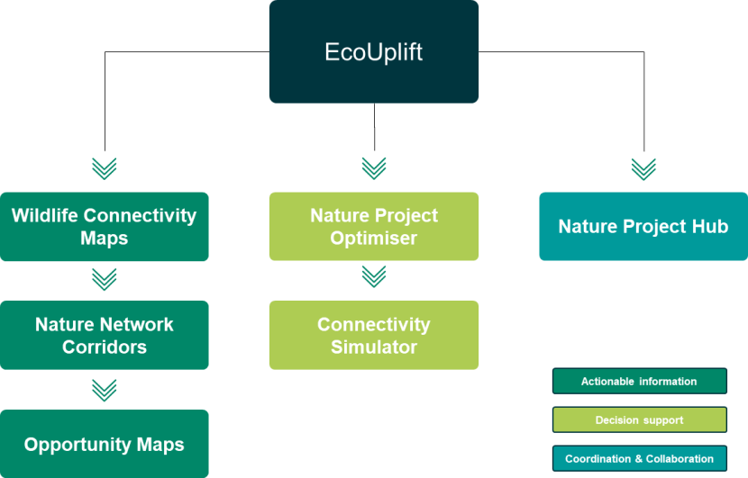
Schematic of the tool showing the different elements that are being built on top of Eco Uplift; wildlife connectivity maps, nature network corridors, opportunity maps, nature project optimiser, connectivity simulator, nature project hub.
EcoUplift - is a web hosted tool used to generate rapid, high-level terrestrial biodiversity and natural capital accounts in the UK.
Wildlife Connectivity Maps - analyse the current state of functional habitat connectivity across Scotland. This is achieved by analysing the willingness of multiple species groups to move through the landscape in its current state.
Nature Network Corridors - identify potential ways of connecting all of Scotland’s 30x30 sites while considering various 'attractors' and 'detractors'.
Opportunity Maps - use the Wildlife Connectivity Maps and a long list of weighted datasets (attractors and detractors) to identify the best places in Scotland to undertake nature recovery projects that contribute to Nature Networks.
Nature Project Optimiser - will enable users to configure a range of parameters, including habitat type, location, budget, and policy or funding alignment, to identify suitable nature-based projects based on their specific objectives e.g., carbon sequestration, biodiversity, or flood regulation.
Nature Project Hub - will be a set of features that aim to improve visibility of and collaboration between nature recovery projects.
There is no obligation to use this product when developing Nature Networks but it is expected to become a key tool within the developing Nature Networks toolbox. As such, over the next couple of years Local Authorities will be offered support by Aecom, and the sponsor organisations NatureScot and Scottish Wildlife Trust, to use the tool to support their ambitions in spatially defining Nature Networks in their area.
The proposed timeline of works is;
-
Oct ’23 – Jan ‘24: Initial work with five Local Authorities (Fife, Dundee, Angus, Highlands and Orkney) to continue to explore needs and develop a process for local authorities to identify their current connectivity and opportunities for the future taking into account their local needs.
-
Jan ’24 – Apr ‘24: Expand the offer to work with remaining Local Authorities, and other partners, to scale up the connectivity and opportunities map to the whole of Scotland
-
Apr ‘24 – Jul ‘24: Develop the Nature Project Optimiser, a decision-support tool that will guide users through their land-use planning, investment, and nature recovery decisions
-
Jul ’24 – Oct ‘24: Connectivity simulations and nature project hub development
-
Oct’24 – Oct ’25: Continued free access and support for Local Authority users
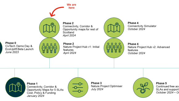
There is currently an offer out to all Local Authorities to engage with AECOM to input into the Nature Network Corridors and Opportunity Maps.
Further updates about the project and tool development will be posted on these pages alongside information on any related events. Please see below frequently asked questions. You can also contact [email protected] if you have specific questions.
FAQ
Is it the objective of the Nature Networks policy to connect all 30 x 30 sites? Does this extend to 30x30 sites that are designated for very different habitat types that wouldn’t ordinarily need to be connected?
Improving connectivity between 30x30 sites is one of the core objectives of Nature Networks and such sites are important nodes within the network.
The Nature Networks framework outlines further objectives such as better connecting people to nature and better connecting locally important sites for biodiversity.
Yes, unless there is a clear reason why a 30x30 site shouldn’t be connected (e.g. an island). The overarching purpose of Nature Networks is to contribute towards reversing the trend of biodiversity loss through improving connectivity to benefit biodiversity.
Sometimes this will be about creating structural connectivity between ecologically similar sites (i.e., more appropriate woodland between two existing woodland sites). Other times it will be about connecting ecologically distinct sites and so connectivity corridors are likely to take the form of a mosaic of biodiversity friendly areas benefitting both the sites they are connecting but also the wider landscape.
Is there a duty on local authorities to provide a map for other people to consult on?
NPF4 identifies that Local Development Plans (LDPs) spatial strategies should establish Nature Networks and so be included in any consultation on these LDPs.
The Nature Networks Framework emphasises the importance of local community and land manager engagement in the development of Nature Networks and this is for the LA to decide how best to act upon.
When would we consider a local authority areas or region is sufficiently networked?
The Nature Networks Framework say’s that a Nature Network will be made up of:
- All 30x30 sites
- Sites that are of local importance for biodiversity
- Better connect people and communities to nearby important areas for nature
The Aecom tool has been developed to include and deliver against each of these criteria and so meets these requirements of the Framework. Please see the Nature Network Toolbox for further guidance on Nature Networks.
Would it be possible to identify a different set of LNCS nodes for different habitat types?
The 30x30 / Nature Network policy does not distinguish between different habitat types. Therefore, the approach we have taken is habitat agnostic.
That said, choosing LNCS on the basis of habitat type for your local authority area may well work for your context. See the above FAQ for further information. Regardless of how you choose your LNCS, we have asked Local Authorities to restrict their choses to 5-10 additional nodes to ensure the corridors don't get too complicated and messy.
How does the tool deal with the urban environment and the urban-rural interaction?
The Nature Network corridors are designed to be attracted to the outskirts of urban areas, whilst trying to avoid going directly through them. For cities which have large areas of urban environments, the corridor will be designed using higher resolution data to design the corridors in order to pick up the small pockets of potential for habitat creation within urban areas themselves.
Can additional 30x30 sites be added into the tool? NatureScot's guidance refers to Other Effective Area-based Conservation Measures (OECM) which could include sites not on existing national datasets.
All future 30x30 sites (including OECMs) will be part of national data sets. AECOM will outline plans for keeping this up to date.
Do these maps take into consideration the local authorities actual land owned i.e. where work can actually feasibly occur without further outreach to non-LA land?
The Nature Network corridors and Opportunities have been designed to find strategic areas for habitat creation regardless of land ownership. This follows guidance from NatureScot around networks being agnostic of land ownership as, for a coherent Nature Network, there will need to be large areas of private land included and incentivised to carry out biodiversity enhancing management.
The third quarter of the project will see the development of the Optimiser tool which will enable users to create their own opportunities by integrating their own land ownership data (e.g. Local Authority owned land).
What are the possible implications of this work for invasive species (INNS)?
The potential spread of invasive non-native species (INNS) should be a consideration for any land use change. The wider Nature Networks Toolbox being facilitated by NatureScot will look to point to useful guidance on INNS.
Do I need to have prior knowledge or be in a technical role to use the tool? And will there be a cost associated with this?
As part of the CivTech 8.3 project, in addition to the mapping exercises that are currently being work on, AECOM are expanding an existing tool of theirs (EcoUplift) to develop a ‘Nature Networks Tool’. The Nature Network Tool will consist of three modules that are intended to support a range of users, including local authorities, to contribute to nature recovery in the ways and places that are of most relevance to them.
These modules include: the Nature Project Optimiser, which will enable users to generate their own corridors and opportunities; the Connectivity Simulator, which will enable users to assess the implications of land-use change on local wildlife connectivity; and lastly, the Nature Project Hub, which will support collaboration on and communication of nature recovery projects. Scottish local authorities have free access to this tool for the duration of the CivTech 8.3 project (until October 2025). Beyond this point, the tool will be available for a fee. The price for this has not yet been set but it has been agreed between AECOM and NatureScot that this will be affordable for local authorities.
Do you intend to rerun the mapping process in light of updated info, changing local priorities and ongoing work to deliver some of the identified opportunity sites?
For the Nature Networks Corridors and Opportunity Maps, these are a point in time views for the purpose of delivering the objectives of the CivTech 8.3 project and it is the expectation that these will be further developed by local authorities. For the connectivity maps, we do think that there would be value in rerunning these periodically, though likely not more frequently than every two years, as baseline conditions at the regional and national scale tend not to change sufficiently quickly to justify anything more frequent at those scales.
That said, as part of the CivTech project we are developing additional tools that will enable local authorities to run these methodologies themselves at the local level. These tools are being developed with local authorities in mind and it is intended that they support them deliver on their statutory obligations. See the above FAQ for further information.
Has there been any ‘sense checking’ of the outputs to ensure that they make sense on the ground and reflect the local context?
These mapping outputs are meant to provide high level information on which to progress strategic decisions.
The methodologies for all mapping outputs have been developed with and validated by AECOM subject matter experts. Further, the methodologies have been developed in close coordination with NatureScot and the initial set of five Scottish Local Authorities.
No site visits have been undertaken to validate outputs against on the ground conditions. For opportunity mapping outputs in particular, we strongly advise that on the ground surveys are conducted prior to an opportunity being implemented.
How are the connectivity maps arranged, are the 10 species groups separated out, and what species do they represent?
The connectivity maps have been designed to model connectivity for broad species groups that have similar habitat requirements, resistance to landcovers and home range. The full methodology and assumptions on those groups will be available alongside the tool in due course.
Later on in the project, we will look to create a small number of “iconic species” maps. Which species will make that list is yet to be confirmed and we welcome input on inclusions.
We have many local biodiversity sites, including some still being assessed. Have these been/ can these be used in the tool?
If local biodiversity sites are captured within the public local nature conservation site dataset (see below) then they are being considered.
For those future sites, there will be the ability to use that dataset alongside the Optimiser (to be developed in Q3) when looking for custom opportunities.
It is important to remember that Nature Networks are not the only means of improving the broader landscape for biodiversity and so it is not the case that every single locally important site is part of a spatially defined Nature Network
Regarding the use of LNCS data, is it possible to check if the data used by the tool is up-to-date?
The Local Nature Conservation sites data has been taken from the Spatial hub Improvement Service (Local Nature Conservation Sites - Scotland - Dataset - Spatial Hub Scotland) on 21/12/2023. We will check for any updates before applying our approach at the end of the engagement.
Do the nature networks corridors and opportunities mapping take into consideration habitat creations impact on flooding?
River-based 30x30 sites are included as Nature Network Corridors in their own right with a land buffer around them. This recognises the important connectivity role waterways play across Scotland’s landscapes and the multiple benefits that can be achieved from habitat improvements along them.
Non-30x30 rivers have also been included as attractors for corridors in the tool, for the same reasons as above, using stretches that do not have riparian woodland habitats as the attractor.
Opportunities proposed along corridors, will consider flooding extent risk and take this into consideration as to what habitat creation opportunities it suggests.
The wider EcoUplift tool, as part of its natural capital calculations can provide information as to potential reductions in flood risk from opportunities.
How are coasts considered or captured in the maps?
There are a number of ways in which coastal habitats are considered in the maps;
- The base map used, Habitat Land Cover Map of Scotland 2022, covers a number of coastal habitats;
- Coastal habitats covered by 30x30 sites and LNCS will act as nodes or attractors.
For LAs with coastlines this will either result a coastline that is either covered by 30x30 sites and LNCS connected with NNCs or with NNCS acting as ‘arms’ or ‘branches’ reaching out from inland nodes to coastal nodes.
Where are coastal habitats not considered;
- Like other habitats, priority coastal habitats that are not covered by 30x30 protection or LNCS are not considered in the NNC modelling.
- Coastal habitats are not one of the 4 opportunity habitats
My LA has already started developing our Nature Network. How will the AECOM derived Nature Network Corridors interact with these?
We understand that local authorities are at different stages of their Local Development Plans (LDP) development and consideration of Nature Networks. Some local authorities, we understand, have already started mapping nature networks in one way or another. This is not a problem.
The purpose of the Nature Networks Corridors (NNC) is to provide an initial, cohesive, national-scale indication of what Scotland’s Nature Networks might look like. These are intended to be a starting point from which Local Authorities develop their own Nature Networks. There is no requirement to use these. Where a local authority has already started developing Nature Networks, there is potentially an opportunity to validate or find opportunities to augment those against the AECOM-generated NNC.
For the National Parks who do not have LNCS, can we use other features / projects?
AECOM and NatureScot will be hosting a session dedicated to exploring this question for the two Scottish national parks.
It is likely that substitute features/ projects could be used as long as they are spatially defined.
My local authority has a large number of LNCS, choosing 5-10 would be difficult. Can you provide guidance on how best to choose these?
It is important to stress that all LNCS within a local authority boundary will be included as ‘Attractors’ for the purpose of the modelling, so will influence the path that a Nature Network Corridor (NNC) takes. By virtue of this methodology, many LNCS will either be included within or be in close proximity to a NNC.
You should focus your choice of LNCS on those sites that are likely to best expand the reach/ spread of the NNC in our local authority. For example, you may want to focus these in areas where there are no, or fewer 30x30 sites.
It is also worth considering how the LNCs you choose may create NNC that ‘pick up’ other LNCs along the way.
There are instances in my local authority where non-listed sites are of greater biodiversity value or strategic importance to designated LNCS. Can these be considered in this NNC activity?
In order to create these three mapping components across all of Scotland in a standardised and efficient manner, we have had to define a methodology that that works for the national, strategic context.
It is important to keep in mind that these Nature Networks Corridors (NNC) are intended to be a high-level, strategic view of what Nature Networks could look like, and a starting point for local authorities. It is expected that local authorities will further refine and develop these, during which process they may wish to add additional sites.
It is worth also keeping in mind that local authorities will have free use of the Nature Networks Tool for the duration of the CivTech project (until October 2025), which will be able to assist them in developing future iterations of NNC as they finalise their Nature Networks.
How realistic are the identified opportunities were?
The opportunities are realistic given the data used to identify them. They are meant to provide high level suggestions and quick ideation over large areas.
They are not designed to be a final output and local knowledge will still be required to check and tweak the opportunity where necessary.
mHabitat opportunities are being identified for four broad habitat types: woodland, grassland, wetland and, heathland. Do they also consider different habitat types within these broad types?
We are limiting the opportunities to these four broad categories given the national habitat cover datasets available and their corresponding accuracy.
We are looking to provide additional guidance as to what priority/specific habitats may be included in the broad categories that need to be taken into special consideration if someone wished to pursue an opportunity (e.g. flagging priority habitats that it would be inappropriate to lose).
How does this work take into consideration the Central Scotland Green Network connectivity mapping exercise already completed?
At this point in the tool development, there hasn’t been a review undertaken between the opportunities being developed through the Nature Networks project and those developed as part of the CSGN work. There is potential to undertake this review going forward.
