Nature Networks - Decision Support Tool uses
A brief look at how the AECOM CivTech 8.3 Tool can be used during Local Authority led Nature Network creation.
The ask from the co-designed Nature Network Framework was for a tool that would, amongst other things, support the mapping and identification of Nature Networks (NNs) including opportunities.
Early in the development of this tool, AECOM are producing three sets of maps covering the whole of Scotland that will act as ‘actionable information’ for the wider tool;
- Strategic Corridors for Nature (formerly Nature Networks Corridors): Strategic routes that link up 30x30 sites, and, where appropriate, priority LNCSs identified by local authorities. These are a starting point from which local authorities can develop their formal nature networks.
- Wildlife connectivity maps: A series of heat maps (with legends) showing the current state of habitat connectivity, told from the perspective of wildlife's willingness or ability to move through existing land-use types.
- Nature recovery opportunity maps: A series of maps illustrating opportunities for the creation for woodland, grassland, heathland, and wetland along Strategic Corridors for Nature
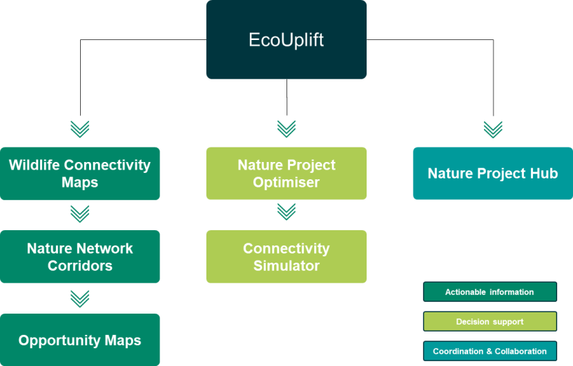
A flow diagram showing the different outputs and functions that sit within the AECOM EcoUplift Tool.
Outputs on the left are actionable information and includes 'Wildlife Connectivity Maps', 'Nature Network Corridors' (now called Strategic Corridors for Nature to avoid confusion with Local Authority defined Nature Networks that will be formally adopted) and 'Opportunity Maps'.
In the middle are decision support tool functions 'Nature Project Optimiser' and 'Connectivity Simulator'
On the right is the coordination and collaboration enabling sharing platform function 'Nature Project Hub'
How each element, particularly the initial set of maps, can support LAs is summarised below.
Strategic Corridors for Nature maps
What it does and how it works?
They show strategic links between 30x30 sites following a least cost path through the landscape while being included by ‘attractors’ such as LNCS and Ancient Woodland.
These Strategic Corridors for Nature deliver against key asks from the Framework, and provide local authorities with a starter for ten in developing their nature networks. Namely:
- They connect together all existing 30x30 sites using a sufficient number of connections (known as redundancy) to maximise the probability of meaningful connections being possible (recognising some landowners may choose not to enact positive changes for biodiversity),
- They incorporate and consider local biodiversity sites (ie. non-30x30 sites) such as LNCS and Ancient Woodland Sites and so begin to ensure that a place-making approach is used and that local priorities are included,
- They pass through or touch on all major towns and cities in Scotland (those with populations over 15 000) and so begin to better connect people and communities to nearby important areas for nature, and
- They are Local Authority border agnostic and so work towards creating Nature Network connections that could work at a regional scale, linking them all into a national scale network.
These corridors are not intended, by design, to be finalised routes for spatially defined NNs as they operate using national data sets with associated limitations and, they are able to take into account a limited number of local/regional opportunities and priorities.
How can it be used in LDPs?
Spatially defined corridors such as those offered by AECOM offer an evidence-based starting point for LDP preparation and stakeholder and community engagement on spatially defined Nature Networks. Clearly demonstrating the scale and ambition at which Nature Networks will be operating and providing a reference point to work from.
-
LAs can identify this map as an evidence source in LDP Evidence Reports. It is not expected that the map needs to be detailed at this stage, but it will be useful to explain how this evidence may be used in the process of planning for spatially defined Nature Networks to feature in the new LDP. Please see the ‘Planning Authorities and Nature Networks’ simplifier on the role of Planning Authorities and Local Development Plans for Nature Networks.
-
Through the stage of Proposed Plans as identified in the simplifier, LAs can use this map as a basis for their Nature Networks, building on it using local knowledge of the area and local priorities through discussions with stakeholders.
-
As part of this iterative process, corridors may move or entirely new corridors could be added or replace those provided by the AECOM decision support tool. Questions to consider when working with stakeholders could include:
-
Given the sites being connected, if structural connectivity is being sought, is the route sensible to achieve this?
-
Are there local priorities/ important biodiversity areas nearby that a corridor could sensibly also be connecting?
-
Are there known restrictions along a corridor, that are unlikely to offer any flexibility with regards to biodiversity improvement, that a corridor should re-routed around?
-
Are there known planned projects (positive or negative concerning biodiversity) that should be factored into the route?
-
Nature Networks should be planned and delivered through a collaborative, bottom-up approach taking into account national and regional, as well as local priorities. Please see the Nature Network Framework regarding delivery principles on decision-making and engagement. The Nature Networks Toolbox will provide further support and guidance on engagement and communication in time.
-
Planning for nature networks, and adding to the baseline provided by the tool, should consider where corridors cross, or link to sites across administrative boundaries. Neighbouring Local Authorities will need to work together to ensure coherency of Nature Networks continues at the regional and therefore national scale.
-
NatureScot will look to ensure all LA adopted spatially defined Nature Networks are bought together and hosted centrally (e.g. on our website or another suitable platform) and would appreciate working with LA GIS colleagues to share this information, providing a platform for viewing the coherent Nature Network across all of Scotland. The AECOM tool will then use this data so that future opportunities and decision-making includes nature networks.
Additional uses?
- Those exploring opportunities on the platform will be able to see where different opportunities for projects will be contributing to a wider, strategic Nature Network. This will help focus nature-based projects in areas that strategically contribute to improving connectivity.
Opportunity maps
What it does and how it works?
Along the strategic corridors, the model will suggest opportunities for habitat creation or enhancement for four habitat types; heathland, grassland, woodland and wetland. These are influenced by the wildlife connectivity maps as well as proximity to areas identified and weighted by local authorities, such as flooding zones, historical sites etc.
These suggested opportunities identify areas along the corridors that will improve connectivity for wildlife and help turn that strategic corridor from a concept to existing on the ground.
It is expected, as with any other opportunities mapping tool, that ground truthing is needed before putting any suggested opportunities into action. Similarly, some opportunities wouldn’t be suitable due to things like land ownership, competing land uses or the presences of specialised species assemblages.
The opportunities once again provide a starter for ten when it comes to project selection. This may be useful particularly when funding opportunities present themselves with quick turn arounds.
They can also be a first step when discussing potential restoration on land owned by partners or other stakeholders. If deciding to go ahead with a strategic corridor, it can be a tool to clearly show where a project is contributing to a wider network and improving connectivity across the landscape. It is anticipated LAs would not lead on much of this project-based work.
How can it be used in LDPs?
We wouldn’t expect to see this opportunity map in an LDP.
Additional uses?
This could be useful for when short-term/unexpected funding opportunities present themselves, and there is a capacity shortage, by providing evidence-based opportunities along corridors for project selection.
Wildlife connectivity maps
What it does and how it works?
These connectivity maps can be an additional data source when establishing a base line for current connectivity in the region. Particularly it can highlight areas where species movement is impeded, for example due to linear infrastructure and similar barriers for movement.
How can it be used in LDPs?
LAs may look to identify this as an evidence source in LDP evidence reports.
Additional uses?
We’d see this as an additional useful data source to inform projects in relations to Nature Networks as well as when making wider planning decisions where it would be useful to know the impacts on connectivity across the landscape.
How will the maps be shared?
AECOM are developing these publicly available, open-source maps are part of the CivTech Challenge. They will be viewable in the EcoUplift platform. They will also be hosted on the ESRI platform for download and can be used for free on other GIS systems.
How will the next stages of the tool contribute?
As mentioned, these first two quarters on the CivTech Challenge have predominantly focused on and delivered the actionable information (as illustrated above) and is due for release by May 2024. In the next two quarters, we will see the development of the other elements of the tool with a full release of all functionalities due in October 2024. See below summaries of how the coming functionalities will support LAs.
Optimiser
- Using the same methodologies defined for the creation of the strategic corridors for nature and the opportunities map, the optimiser will enable users to generate their own corridors and habitat opportunities, anywhere in Scotland.
- Users will be able to set a range of parameters to generate results that align with their objectives, for example location, habitat type, cost, target ecosystems service(s), or policy alignment.
- Where a Local Authority has an agreed upon spatially defined Nature Network, whether or not this was derived using the original AECOM outputs – as a user of the tool it will be possible to import the GIS shapefile into the tool to be considered when using the optimiser.
- It is hoped that the optimiser could particularly help LAs explore their own land holdings.
- Once available, the tool will include the final spatially defined nature networks as a data layer so future opportunities can be flagged as to whether they will be contributing to a nature network.
Connectivity simulator
- LAs will be able to rerun the connectivity model based on changes presented by an opportunity or other project land-use change e.g. those proposed through planning applications. This will allow LAs to see how land-use change proposed by them or anything other party would impact on wildlife connectivity in the area, helping to make informed decisions.
- The results provided by the optimiser and connectivity simulator may be helpful in funding bids for projects or for assessing project potential impacts.
Nature Project Hub
- Projects add to or developed through the tool will be publishable to a publicly available project hub. Visitors to the hub will be able to search through projects, finding information of interest to them. As. nature project develop, the project profiles can be update, e.g. with text updates and images,
- The Hub can be a location for LAs to showcase the nature recovery work being undertaken by them and their partners.
- Visitors to the hub e.g. community members, can register their interest in and follow specific projects, or even be invited to contribute to the project profile for future updates.
- It is hoped this will help increase visibility of nature recovery projects across Scotland, facilitate collaboration between partners, and, as a result, increase the flow of finance to nature recovery projects.
Further Information
Detailed guidance on methods used in the tool have been sent/can be asked for from AECOM.
