Nature Networks Interim Guidance for Local Authorities
This is interim guidance for LAs between the period of the publication of the NPF4 – which requires the development and strengthening of Nature Networks as a mechanism for protecting and enhancing biodiversity - and the publication of the Nature Networks Framework.
This is interim guidance for LAs between the period of the publication of the NPF4 – which requires the development and strengthening of Nature Networks as a mechanism for protecting and enhancing biodiversity - and the publication of the Nature Networks Framework.
Please visit the Nature Networks webpages for up-to-date information.
The SBS Delivery Plan will propose each that Local Authority have spatially defined Nature Networks that connect important areas for biodiversity.
A Nature Network connects together nature-rich sites including restoration areas and other environmental projects, through a series of areas of suitable habitat, habitat corridors and stepping-stones.
The primary purpose of a Nature Network is ecological connectivity. Nature networks have two main strands;
- Connecting all sites contributing towards 30x30 these are protected areas (e.g. SSSI, European sites, Ramsar, National Nature Reserves) and Other Effective Area-based Conservation Measures (‘OECMs’, a new type of nature conservation area still to be defined for Scotland, but sites likely to be established over the next few years and will broadly follow guidelines produced by the IUCN. Further information will feature in the 30x30 framework). In connecting these sites, networks should incorporate sites locally important for biodiversity (e.g. Local Nature Reserves (LNRs), Sites Important for Nature Conservation (SINCs), Local Nature Conservation Sites (LNCS), country & regional parks, etc.). These will most likely be new connections.
- Connecting biodiversity across and between rural, urban, and the peri urban area. Nature Networks from urban areas should connect outwards into the wider nature network. Again, the network will be built around locally important areas for biodiversity and some of these networks may have already been mapped via existing schemes and projects e.g., Green Networks, open space strategy, providing a good basis to build on.
The process of identifying Nature Networks in a local authority
Local Development Plans should facilitate Nature Networks in Local Authority areas. The framework stresses that the process of identification and implementation must be informed, ensure meaningful engagement, and empower and equip a bottom-up approach to nature network creation. Initial stages of identifying local Nature Networks should include;
- Capturing spatial data and/or identifying data sources
- Identifying and recognising 30 by 30 sites as the backbone of local nature networks
- Identifying other locally important sites including the locations of local biodiversity priorities and targets
- Identify already established corridors and connections
- Opportunity mapping including engagement capturing local knowledge to identify potential areas for improvement
There are a number of ways to approach opportunity mapping that can be used, both in terms of technical tools and decision-making processes, such as the Central Scotland Green Network connectivity map and the environmental decision-making process outlined in the Ecological Coherence Protocol. NatureScot is in the process of developing (via a CivTech challenge) a new tool that can help local authorities in identifying potential Nature Networks through opportunity mapping. The tool aims to provide a connectivity map of Scotland and be able to present the options available for connecting important areas for biodiversity.
The purpose of opportunity mapping tools is not to dictate where the Nature Network will be, but to outline the options available, that can then be used as the basis for discussions with local communities, land owners and managers, and experts to decide where best the Nature Network can and should go, inline with local priorities for both climate and nature.
Simplified visual explanation of the potential process.
Note, these images are purely to illustrate the process, and are not to be taken as instructive. 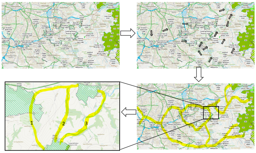
Maps showing the steps to mapping current and potential Nature Networks
Click for a full description
Four maps showing the steps to mapping current and potential Nature Networks. The first shows an OS with all the protected areas highlighted. There is then an arrow to a second version of the same map with arrows pointing to areas identified as good for nature. A second arrow points to a third version of the map with links and connections between these areas highlighted. The final arrow points to a forth, zoomed in version, of the map to one of the connections were it can be seen that three different connections have been highlighted between three protected areas. The three connections are numbered one, two and three and loosely follow natural features on the map such as rivers. |
This identification process, and governance structure, should include Local Authorities as detailed in the Nature Networks framework and should take advantage of regional partnerships, particularly where already established. A governance structure should include key delivery partners, as well as being representative of locally important stakeholders considering diversity and inclusion, and may include Local Authority planners and/or Local Biodiversity Officers (Ecologist), a Regional Land Use Partnership (RLUP) or Deer Management Group (DMG), climate adaptation partnership, and NatureScot local operational staff, alongside other key nature network actors (e.g. NGOs). Such an approach would reduce resource requirements on individual Local Authorities, encourage community empowerment and a just transition. The exact form of governance at the local level will ultimately be decided with the Local Authority.
What will (and won’t) constitute a Nature Network?
A nature network needs to provide a high level of ecological connectivity, providing a habitat corridor, with minimal use of ‘stepping stones’, given that for many species movement is limited.
The form such a corridor might take could be very varied, mirroring the variety of habitats that are found across Scotland and will be context specific, considering the areas in which the network connection is linking together. Examples include waterways with intact riparian habitats, native woodlands, non-designated natural landscapes (e.g. LNCS), agricultural land with suitably wide hedgerows/ tree corridors, agricultural land grazed to support biodiversity rich meadows, areas under effective agroforestry or a series of wetland habitats (e.g. pools, marshes, boggy areas, scrapes) connected by natural habitats.
In the rural context, the following, whilst often positive and contributing towards biodiversity, are unlikely to constitute part of a Nature Network (although may be necessary in limited stretches where the landscape is highly modified presenting a bottle neck); thin hedgerows/ tree corridors, unplanted field margins that are to be bought back into rotation, meadows and similar with unsuitable levels of grazing, waterbodies that are heavily influenced/ controlled, areas of land that are highly impacted by invasive non-native species (INNS), and highly disturbed areas (e.g. road verges).
Within a more urban setting, as well as any of the above, Nature Networks could also include road verges that have been significantly improved for biodiversity, parks and green spaces that are being managed to maximise biodiversity (e.g. native species, variety of habitats, suitable management, minimal chemical control etc), waterways that have been reopened and/or restored so they are not channelised and present biodiversity opportunities, as well as smaller scale components such as rain gardens, green roofs, vacant and derelict land or active travel routes that have green infrastructure with biodiversity value. To contribute, these areas must be helping connectivity for biodiversity, providing a connection to a wider nature network.
In the urban context, green areas/spaces that are not delivering for biodiversity or, managed in a way to promote and maximise biodiversity would not count towards a Nature Network (e.g. playing fields with little to no biodiversity or parks dominated by cut grass and ornamental plants). This means that there is likely to be overlap with already established networks such as green and blue space networks or green infrastructure networks.
In both the urban and rural context, areas that are not currently providing connectivity – but have the potential to do so – could be included within a spatially defined nature network. Such potential sites should have a clear, assured, and time bound route to improve their contribution to biodiversity and connectivity. Nature Networks should be identified, and set up, so as to provide long term connectivity routes. Long term solutions, where possible, will allow for greater benefits with less resources.
Policy
While the policy drivers for Nature Networks are the Scottish Biodiversity Strategy and NPF4, there are wider implications for the Just Transition, climate mitigation and adaptation plans, and community empowerment and ownership.
The primary policy mechanism for establishing and detailing your nature network is through Local Development Plans and meeting your Biodiversity Duty. Nature Networks are to be aligned and mainstreamed with a number of policies and plans including Local Biodiversity Action Plans, Climate Change Duty and Plans, Forestry and woodland Plans, Open Space Strategies, Community Food Growing, Community Planning Partnerships (Community Plan/ Local Outcome Improvement Plans), Supplementary Guidance, Sustainability Plans, Council Plan, Health and Social Care Partnership, Regional Economic Forum and so on. All providing the opportunity to mainstream biodiversity across local government. This is an important commitment of the Edinburgh Declaration which 18 authorities and COSLA support, and which was adopted by the UN Convention on Biological Diversity at COP15.
More information on policy can be found in the Nature Networks Framework.
Support for Local Authorities
Many actions taken across local authority policy areas area already contributing to Nature Networks, however, it is recognised that successful Nature Networks will require proper resourcing.
NatureScot are currently working with Scottish Government, COSLA and local authorities to better understand what tools would be useful in a Nature Networks toolbox, as detailed in the Nature Network Framework, to aid Local Authorities and delivery partners in establishing Nature Networks, including signposting to potential funding routes.
In the short term, an additional £5m of funding has been provided to Local Authorities via the Nature Restoration Fund to support initial activities towards Nature Networks (see additional guidance on this). Future funding mechanisms will be further developed.
