Guidance - Assessing the cumulative landscape and visual impact of onshore wind energy developments
Published: 2021
This is a more accessible version of our guidance on the cumulative landscape and visual impacts of onshore wind farms. It was published in March 2021 and replaces the previous cumulative impacts guidance published in 2012. There have been no changes to the assessment methodologies, which are the same as described in the 2012 document. The only changes made to the content are the removal of the section on cumulative impacts on birds (published as a separate document in 2018 Assessing the cumulative impacts of onshore wind farms on birds) and the removal of some outdated contextual information.
Introduction and scope of this guidance
Purpose
Renewable energy is an increasingly important part of Scotland’s economic, social and environmental success. The pace of renewable developments has increased rapidly in recent years and wind farms are now familiar sights in many parts of the country. We support the development of wind farms and recognise the many benefits they bring.
The cumulative impacts on our nature and landscapes need to be carefully considered and this guidance sets out our advice on assessing cumulative landscape and visual impacts. Scottish Planning Policy (SPP) highlights that cumulative impacts may limit the capacity for further development and the need to consider cumulative impacts in the decision making process (SPP para 169).
This guidance complements other advice on the design and assessment of wind farms, which can be found on our website.
What are cumulative impacts?
Cumulative impacts are the combined effect of a set of developments. Different types of cumulative impacts are discussed below and in section 7 of the Guidelines for landscape and visual impact assessment (version 3, 2013)
Assessing cumulative impacts
Understanding the impacts of a proposed wind farm when it is seen alongside others in the area requires a clear, transparent and detailed assessment process. The process needs to identify the overall impacts which may arise from a group of projects and distinguish the contribution of each individual project to these. Some examples are provided below.
In many parts of Scotland the level of wind farm development is now such that a large number of wind farms will have to be taken in to account. The examples below are necessarily simplified to illustrate the issues, but the principles for multiple developments are the same.
Examples of cumulative impacts
Imagine two separate developments, A and B. The cumulative effect of both developments taken together need not simply be the sum of the effect of A plus the effect of B; it may be more, or less. This is best demonstrated using some examples as shown below
- An isolated house A in the countryside has a visual impact, standing out in its natural setting. Another isolated house B has a similar visual impact, taken alone. However if the two houses are sited close together, the visual impact of the two together may be only a little greater than for either house A or B taken alone, as they will appear as a single cluster.
- Wind farm A sited on a ridge on one side of a valley is highly visible but acceptable, providing a single visual focus on an otherwise unremarkable skyline. A second wind farm B on a ridge on the other side of the valley would have a similar effect, if it were on its own. However, the effect of having two wind farms sited on either side of the valley may be to make the observer feel surrounded by development. The combined effect of both may be much greater than the sum of the two individual impacts.
When to take account of cumulative impacts, scoping and information requirements
When to take account of cumulative impacts
Cumulative impacts should be considered:
- in strategic planning (as part of the preparation of spatial guidance for wind farms) and
- in development management (in the context of a site specific assessment).
Although the two forms of cumulative assessment share common principles, it is important to distinguish between the two processes.
Assessing cumulative impacts in strategic planning
Strategic cumulative impact assessment should be undertaken as part of a planning authority’s preparation of:
- Development Plan policies and Supplementary Guidance;
- Strategic Environmental Assessment; and
- Renewable energy landscape capacity studies.
In all cases, the focus is on forward planning: setting out the vision for wind farm development; and determining the thresholds of acceptable change, where the most suitable locations for development are, and what might be an appropriate design and scale. Our guidance on Spatial Planning for Onshore Wind Turbines provides more detailed advice.
Assessing cumulative impacts in development management
Cumulative impacts should be assessed where a proposed development involves:
- a new development in combination with one or more existing or approved but unbuilt development;
- an extension to an existing or approved but unbuilt development;
- more than one development proposed at the same time within an area; or
- any combination of the above.
An assessment should be carried out by the developer, as part of an Environmental Statement or environmental information, and reviewed by the determining authority (the planning authority or the Scottish Government) and consultees.
Scoping
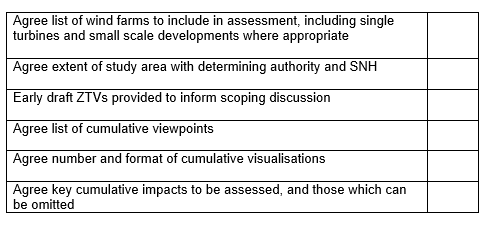
Cumulative assessment of wind farms can be complex, especially when multiple proposals are being taken forwards at the same time. It is important to agree the scope of the assessment early in the process and this section provides advice on the key decisions required. A scoping checklist is provided in Annex 1 to help ensure that assessments are complete and that agreement can be reached as quickly as possible.
Due to the length of time applications can take to progress to application stage it may be necessary to include additional sites and viewpoints later in the process. However, this should be kept to a minimum to reduce delay.
Which wind farms to include in the assessment?
An assessment of cumulative impacts associated with a specific development proposal should encompass the impacts of the proposal in combination with:
- Existing development, either built or under construction;
- Approved development, awaiting implementation; and
- Proposals awaiting determination within the planning process with design information in the public domain. Proposals and design information may be deemed to be in the public domain once an application has been lodged, and the decision-making authority has formally registered the application.
The decision as to which proposals in the planning / consenting system should be included in an assessment is the responsibility of the determining authority.
The cumulative impact assessment (including illustrative material) needs to distinguish between predicted impacts in each of the relevant scenarios. For example, a proposal in combination with existing and consented developments, or proposal in combination with existing, consented and planning application stage developments.
The area within which a cumulative assessment is required should relate to the issues involved, and should not be limited by local authority boundaries.
Occasionally it may be appropriate to include proposals in an assessment which are at earlier stages of development (including at scoping), particularly where clusters of development or “hotspots” emerge, or where proposals are adjacent to one another. However, a degree of pragmatism is required to enable proposals to progress to determination, and to cater for proposals which may not yet be in the public domain.
Cumulative impact assessment can be expensive and time consuming, as it requires knowledge, at least in outline, of the impacts of each existing or proposed development within the vicinity. We therefore only seek cumulative impact assessments where we consider that a proposal could result in significant cumulative impacts which could affect the eventual planning decision.
The key principle for all impact assessments is to focus on the likely significant impacts and those which are likely to influence the outcome of the consenting process.
Timing of new proposals entering the planning process
Planning authorities are empowered under EIA Regulation 19 and Article 13 General Development Procedure (S) Order 1992 (or the relevant section of the Electricity Works EIA regulations) to seek additional information from the applicant at any point in the determination of the application.
If an Environmental Statement which includes assessment of cumulative impacts is nearing completion when a new planning proposal is submitted for another site in the same area, the decision-making authority may regard the new application as a material consideration. They may therefore request the first developer to extend its cumulative impact assessment to take account of the new application.
However, a request at such a late stage may conflict with the applicant’s right for a decision within prescribed timescales. Thus, while it might be preferable for the potentially competing applications to be determined together, a planning authority might conclude that it would be unreasonable to defer determination of an outstanding application as successive new applications are submitted.
Once an application has been submitted and is accompanied by a complete and satisfactory Environmental Statement, any further assessment to take account of new proposals is likely to cause delay. The determining authority may consider that it cannot reasonably require further cumulative assessment by the applicant. In some locations the level of development is such that cut off dates should be considered to enable applications to progress.
The same considerations may apply where an application becomes subject to examination by hearing or inquiry. Inquiries and hearings can introduce considerable delays and a developer may opt to present new cumulative assessment, updated to include all extant proposals at the time of the examination.
Information from competing developers
Cumulative impact assessments normally require details of each development in isolation, (e.g. data in respect of all relevant projects in relation to proposed turbine model, dimensions and detailed grid references of proposed turbine locations). Difficulties may arise if developers are unwilling to share information.
Environmental Statements, once submitted to the planning authority, are public documents but subject to copyright. The information may be used by other developers but it may not be copied without permission. There is no compulsion on a developer to release any data supporting the ES, unless the planning authority formally requires that information as part of its assessment of their proposal.
Planning authorities (and the Scottish Government) should require developers to cooperate over the exchange of information where cumulative assessment is required and needs data out with publicly available Environmental Statements.
Assessing cumulative landscape and visual impacts
Introduction
The cumulative impact of wind farm development on landscape and visual amenity is a product of:
- the distance between individual wind farms (or turbines),
- the distance over which they are visible,
- the overall character of the landscape and its sensitivity to wind farms,
- the siting and design of the wind farms themselves, and
- the way in which the landscape is experienced.
The combination of single turbines and small clusters of turbines can raise the same issues. Where the cumulative impacts of these are significant, they require assessment and this should be agreed at scoping stage (Assessing the impact of small-scale wind energy proposals on the natural heritage guidance).
The magnitude of cumulative change may be different from the magnitude of change brought about by the development when considered on its own. The aim of the cumulative assessment is to identify the magnitude of additional cumulative change which would be brought about by the proposed development when considered in conjunction with other wind farms. A range of parameters should be considered, including:
- the number of other wind farm projects which would be visible in the landscape in each of the different scenarios (existing, consented or application stage);
- direction to each of the projects;
- distance to each of the projects;
- the number and height of turbines at each of the projects – which may also be expressed as the horizontal and vertical angle occupied by turbines – and any access tracks and grid connections; and
- duration of the change (i.e. age of constructed wind farms and the planning status of the projects).
Cumulative landscape impacts
Cumulative landscape impacts can change either the physical fabric or character of the landscape, or any special values attached to it. For example:
- Cumulative impacts on the physical fabric of the landscape arise when two or more developments affect landscape components such as woodland, dykes, rural roads or hedgerows. Although this may not significantly affect the landscape character, the cumulative effect on these components may be significant – for example, where the last remnants of former shelterbelts are completely removed by two or more developments.
- Cumulative impacts on landscape character arise when two or more developments introduce new features into the landscape. In this way, they can change the landscape character to such an extent that they create a different landscape character type, in a similar way to large scale afforestation. That change need not be adverse; some derelict or degraded landscapes may be enhanced as a result of such a change in landscape character, especially where opportunities for new woodland planting, or peatland restoration are maximised, for example.
Wind farms may also have a cumulative effect on the character of landscapes that are recognised to be of special value. These landscapes may be recognised as being rare, unusual, highly distinctive or the best or most representative example in a given area. This recognition may take the form of national or local designations (for example, National Scenic Areas or Special Landscape Areas), citations in development plans, community plans or other documents, or inclusion in Wild Land Areas. (Note – Wild Land Areas are not designated, but have been identified as nationally important in Scottish Planning Policy.)
Cumulative impacts on visual amenity
Cumulative impacts on visual amenity can be caused by ‘combined visibility’ and/or ‘sequential impacts’:
- Combined visibility occurs where the observer is able to see two or more developments from one viewpoint. Assessments should consider the combined effect of all wind farms which are (or would be) visible from relevant viewpoints. Combined visibility may either be in combination (where several wind farms are within the observer’s arc of vision at the same time) or in succession (where the observer has to turn to see the various wind farms).
- Sequential impacts occur when the observer has to move to another viewpoint to see different developments. Sequential impacts should be assessed for travel along regularly-used routes like major roads, railway lines, ferry routes, popular paths, etc. The magnitude of sequential effects will be affected by speed of travel and distance between viewpoints.
Two wind farms need not be intervisible – or even visible from a common viewpoint – to have impacts on the landscape experience for those travelling through, or living in an area. For example, it may be necessary to consider the cumulative impacts of wind farms on users of scenic road routes, or routes for walkers, cyclists and other recreational users, along their full length within the agreed study area. The assessment should also consider impacts on key recreation resources such as long distance routes, coastal paths and core paths.
Cumulative visual impacts are discussed in more detail in the GLVIA3. The magnitude of cumulative change depends on the scale, nature, duration and frequency of combined and sequential views (glimpses or more prolonged views; oblique, filtered or more direct views; time separation between sequential views).
Undertaking a Cumulative Landscape and Visual Impact Assessment
The purpose of a Cumulative Landscape and Visual Impact Assessment (CLVIA) is to describe, visually represent and assess the ways in which a proposed wind farm would have additional impacts when considered with other consented or proposed wind farms. It should identify the significant cumulative impacts arising from the proposed wind farm.
The assessment should be proportionate to the likely impacts and all CLVIA should accord with the guidelines within GLVIA3. The emphasis should be on the production of relevant and useful information, highlighting why the proposals assessed have been included and why others have been excluded, rather than the provision of a large volume of information.
The flow chart in Figure 1 summarises the recommended CLVIA process for wind farms. The process is described in more detail below. This is generic guidance only. The number of proposals in an area and the timing of applications give rise to development scenarios of varying complexity. Professional judgement should inform the scope of the study to be undertaken.
Figure 1 - Flow chart summarising CLVIA for wind farms
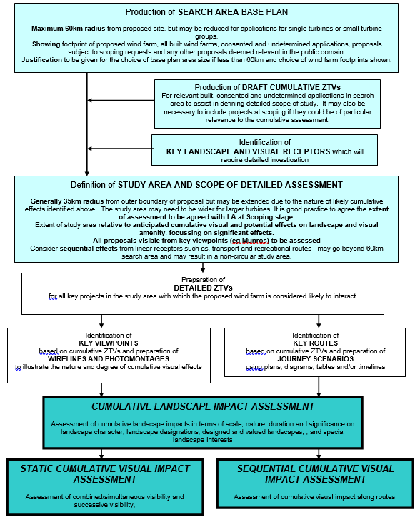
Figure 1: Summary of CLVIA for wind farms
Click for a full description
- Production of a search area base plan Maximum 60km radius from proposed site, but may be reduced for applications for single turbines or small turbine groups; Showing footprint of proposed wind farm, all built wind farms, consented and undetermined applications, proposals subject to scoping requests and any other proposals deemed relevant in the public domain; Justification to be given for the choice of base plan area size if less than 60km and choice of wind farm footprints shown.
- Production of draft cumulative ZTV For relevant built, consented and undetermined applications in search area to assist in defining detailed scope of study. It may also be necessary to include projects at scoping if they could be of particular relevance to the cumulative assessment.
- Identification of key landscape and visual receptors The receptors that will require detailed investigation.
- Definition of study area and scope of detailed assessment Generally 35km radius from outer boundary of proposal but may be extended due to the nature of likely cumulative effects identified above. The study area may need to be wider for larger turbines. It is good practice to agree the extent of assessment to be agreed with LA at Scoping stage; Extent of study area relative to anticipated cumulative visual and potential effects on landscape and visual amenity, focussing on significant effects; All proposals visible from key viewpoints (eg Munros) to be assessed; Consider sequential effects from linear receptors such as, transport and recreational routes - may go beyond 60km search area and may result in a non-circular study area.
- Preparation of detailed ZTVs For all key projects in the study area with which the proposed wind farm is considered likely to interact.
- Identification of key viewpoints and preparation of wirelines and photomontages Key viewpoints based on cumulative ZTVs; Wirelines and photomontages to illustrate the nature and degree of cumulative visual effects.
- Identification of key routes and preparation of journey scenarios Key routes based on cumulative ZTVs; Journey scenarios using plans, diagrams, tables and/or timelines.
- Cumulative Landscape Impact Assessment Assessment of cumulative landscape impacts in terms of scale, nature, duration and significance on landscape character, landscape designations, designed and valued landscapes, and special landscape interests; Static Cumulative Visual Impact Assessment of combined/simultaneous visibility and successive visibility; Sequential Cumulative Visual Impact Assessment of cumulative visual impact along routes.
It is important to have a clear view of the context for a cumulative impact assessment in order to focus on those wind farms and/or issues where there is potential for a significant effect. A phased approach to defining the study area for a cumulative impact assessment is recommended.
The starting point for the assessment is preparation of a search area base plan. This should identify all the wind farm projects which are relevant for the subsequent CLVIA. The projects to be considered in the detailed assessment will be selected from the base plan.
A clear and legible search area base plan should be produced to show all of the following within a radius of up to 60 km (depending on the individual proposal, smaller developments should use a smaller radius in agreement with the Planning Authority):
- any constructed or consented wind farm;
- any undetermined wind farm application;
- any wind farm proposal which has been subject to an EIA scoping request to the relevant authority; and
- any other wind farm proposal that the Planning Authority considers relevant for study and which is within the public domain (eg as a result of a public announcement or community meeting).
Note – due to the very large number of small scale (three or fewer wind turbines) proposals in the planning system in some areas of Scotland it may not be practical to include all of these in the search area base plan. The Planning Authority should be consulted for the most up to date information and to confirm which sites should be included.
Note – installed, consented and proposed offshore wind farms should also be presented on the base plan to enable a decision on whether to include these in the assessment.
The precise study area should then be selected from within the search area base plan and agreed with the planning authority. The applicant must consider what the likely significant impacts will be within the search area, using these to propose the study area for more detailed assessment. Key considerations will include:
- Sequential impacts on key routes
- Intervisibility with other developments
- The existing pattern of development
The onus is on the applicant and their consultants to use the base plan and initial assessment to identify the likely significant impacts and use these to define an appropriate study area and methodology before approaching NatureScot for a view.
Generally, for the current generation of turbine size, the study area should extend to a minimum of 35km from the outer margin of the wind farm in question, though this may need to be increased for larger turbines. Our Visual representation of wind farms guidance suggests appropriate Zone of Theoretical Visibility (ZTV) distances for different sizes of turbines.
The size of the study area should also be influenced by the locations and ZTVs of other wind farms likely to interact with the new proposal; and by transport routes to be assessed for sequential impacts. The study area need not be circular in shape and may extend further in some directions than others. Sequential impacts may need to be assessed for a distance of more than 60km from the proposed wind farm.
Scope of detailed cumulative assessment
The list of projects to be included in the detailed assessment should be clearly set out with an explanation of how the scope has been determined (e.g. ZTV analysis, checking on site, previous applications). A checklist could help to explain this: it would set the projects against a “menu” of priorities, including distance from the proposal, certainty of construction, etc. The relevant receptors (landscape character areas, designated landscapes, designed or otherwise valued landscapes, visual receptors, including sequential routes through the study area) should also be listed.
The assessment should clearly describe the baseline conditions by identifying existing wind farms and the extent to which these have altered landscape character and affected sensitivity to wind farm development. The CLVIA should focus on the significant cumulative changes likely to be brought about by the new proposal, i.e. on key routes, views or character areas.
The CLVIA should separately identify the sensitivity of the landscape and visual amenity resource and the predicted magnitude of cumulative change arising from each of the relevant scenarios, for example:
- the proposed wind farm with existing operational wind farm developments and those under construction;
- the proposed wind farm with existing and consented but unbuilt wind farm development;
- the proposed wind farm with any application stage proposals;
- the proposed wind farm with any other wind farms, along with other proposals in the planning system, which could include those at scoping stage if appropriate.
‘Zone of Theoretical Visibility’ studies
‘Zone of Theoretical Visibility’ (ZTV) analysis is described within the Visual representation of wind farms guidance. This section provides more detailed advice on cumulative ZTV studies.
Cumulative ZTVs should be produced for all existing and consented developments as well as undetermined applications in the initial search area with which the proposed wind farm is likely to interact and result in significant cumulative impacts. ZTVs provide a useful tool to assist in the refinement of the scope of a cumulative assessment. There are various ways in which the ZTVs can be presented, including the baseline and:
- proposed site ZTV;
- landscape character types and proposed site ZTV;
- landscape designations and valued landscapes, such as Wild Land Areas and proposed site ZTV;
- sequential routes and proposed site ZTV;
- paired ZTV (i.e. application wind farm plus one other);
- ZTVs which show a sub-set of projects: the proposal under consideration plus selected others – which may be chosen according to geographic proximity to one another, similarity in ZTV or in relation to status, i.e. both consented, or both at application stage;
- comparative ZTV which illustrates the extent of additional visibility of new turbines where they are being proposed as part of a wind farm extension, or an alteration to an application.
Cumulative ZTVs should clearly show those areas from where one or more wind farms are likely to be seen. Each wind farm and its ZTV should be shown in a different colour and be clearly named. In the case of a ZTV showing three wind farms it will be possible to illustrate the overlapping areas using separate colours e.g. red, blue and yellow to represent each development (with corresponding overlaps of orange, green, purple etc.) or hatching in different directions.
Where four or more wind farms are involved, ZTVs may become difficult to interpret and a series of additional, separate cumulative ZTVs may be required to show the cumulative impacts clearly.
Agreement on groupings of wind farms for separate cumulative ZTVs should be reached with the relevant planning authority(ies) and NatureScot.
Early drafts of ZTVs can help the Planning Authority and NatureScot to advise on the selection of viewpoints for cumulative impact assessment and routes for sequential cumulative assessment. These should be provided for pre-application requests for advice and/or meetings, and included in scoping requests where possible.
Selecting viewpoints and assessing fixed positions for cumulative visual impacts
Locations for viewpoints should be identified by the applicant and agreed with the determining authority in consultation with NatureScot. Detailed guidance on viewpoint selection is contained in the Visual representation of wind farms guidance.
The selection of cumulative viewpoints should be based on an analysis of the draft cumulative ZTVs, ideally at the initial scoping stage of the LVIA so that, as far as possible, viewpoints are selected which will serve both the LVIA and CLVIA. All relevant data may not be available at the outset. Additional viewpoints may be required once the data are available and have been analysed. In areas where there have already been a number of wind farm proposals it may be useful to select viewpoints that have been used for previous wind farm CLVIAs. In many locations the level of development is such that most viewpoints will now be cumulative in nature.
Viewpoints should be chosen to represent the following scenarios:
- Combined or simultaneous visibility occurs where the observer is able to see two or more developments from one viewpoint, without moving his or her head; and
- Successive or repetitive visibility occurs where the observer is able to see two or more wind farms from one viewpoint but has to move his or her head to do so. Visualisations, such as 180 or 360 field of view wirelines, will be useful in assessing these impacts and should be supported by text or tables describing the impacts.
A degree of pragmatism is required to limit the number of viewpoints to those which are likely to provide useful information to inform decision making.
Sequential visual assessment and selection of routes for analysis
Routes to be assessed should be defined and agreed with the Planning Authority as part of the baseline LVIA. The extent of these study routes should be informed by the 60km search area base plan drawing and the cumulative ZTVs. They may extend beyond this in some situations, for example particularly important or busy travel routes, or particularly sensitive locations.
A “journey scenario” should be considered for routes that may have significant cumulative impacts, and the description of available views and how these may be affected by the proposal may note:
- direction of view (‘direct’, ‘oblique’, ‘aligned on route’, or ‘looking NW of route’ etc.);
- distance from nearest turbine; and
- distance over which the effect would occur.
It can also be helpful for the assessment to identify the likely duration of the predicted effect. For example, ‘assuming an average speed of travel ‘x’, this effect will be apparent for approximately ten minutes between 8 and 12 km from the nearest turbine’. The journey scenario can be illustrated in various ways as described in ‘illustrative methods’ below.
Cumulative assessment of single turbines, or small groups of turbines
Single or small groups of 2 or 3 wind turbines raise specific issues for cumulative impacts and their appraisal. These include:
- when cumulative issues occur with both larger wind farm development and/or other single/small scale development;
- multiple small scale and single turbine developments being proposed in a particular region, with complex cumulative impacts arising; and
- introduction of development to landscape types, or parts of Scotland which have not yet been subject to larger wind farm development.
Guidance on the preferred approach to cumulative assessment of single or small groups of turbines can be found in our guidance Assessing the impact of small scale wind energy proposals on the natural heritage. This sets out indicative levels of information to be submitted by developers which, although less than that expected for larger proposals, should be of a suitable standard to enable easy appraisal by consultees.
Assessment of micro renewables proposals (<50kw) is detailed in our guidance Micro renewables and the natural heritage. Applications at this scale are unlikely to require, or be included in CLVIA.
Illustrative Methods
The predicted cumulative impacts should be clearly portrayed in accordance with GLVIA3 and the Visual representation of wind farms guidance. All relevant proposals should be depicted (where practical) in all of the relevant illustrative material (i.e. wireframes, photomontage, study area map).
The range of illustrative tools which can help in CLVIA is constantly evolving. Some of the available tools which have been found to be of particular value are:
- Wireline views are most commonly used to show installed, consented and as yet undetermined applications in combination. It is important that the turbines, or clusters of turbines, are clearly presented using different colours (which are clearly visible) to distinguish between wind farms as necessary. Only the turbines relating to the proposal need to be numbered. Interpretive text and data should be positioned carefully to avoid cluttering the wirelines. A separate appendix showing wirelines with numbered turbines may be appropriate.
- Photomontages will usually be of most value for views within 20km of a wind farm site. However this will depend on the specific wind farm design and environmental conditions and consequently this parameter should usually be discussed and agreed with the determining authority and consultees.
In some circumstances it may be useful to show more distant developments in both wirelines and photomontages. Where these are so distant that they cannot meaningfully be displayed on the illustration, a note showing the location and approximate extent of the development will suffice.
Where the baseline has changed, it will often be necessary to provide up to date photographs from viewpoints. For example, if other wind farms (or indeed other forms of development) have been built since the original photography was taken.
A 'wind rose' diagram, shaded to show the direction (arc of view) and distance of wind farms visible for 360 degrees, can often be helpful, especially from important summit viewpoints.
Sequential impacts can also be illustrated in several ways:
- plan showing visibility of different projects from a route denoted by coloured arrows on mapped base;
- diagram showing visibility of different projects from a route. This could take the form of a colour-coded timeline linked to the colours used in the ZTV;
- table showing predicted visibility by length of route affected by each project, including commentary text on every 10km explaining where each project is visible and the nature of this visibility;
- colour coded sequential bar chart or “timeline” showing distance, duration of view and whether it is direct, oblique, screened, etc., with the colours for each wind farm matching those used in the ZTV. An analysis of the significance of such quantitative data is needed.
Computer generated moving images (“drive throughs”) or videomontage techniques may also be appropriate to assist CVIA, particularly in respect of cumulative sequential impacts. This technique may be particularly applicable to assessment from moving receptors such as trains or ferries or in assessing wind farm extension applications where different turbines with different heights and rotor speeds are being used.
Description and assessment of cumulative landscape impacts
The study of potential cumulative landscape impacts and related impacts should include the description and assessment of the following issues:
- Impacts on landscape character. The cumulative (i.e. additional) effect of proposed development on existing landscape character should be described, particularly in relation to key landscape characteristics. It is likely that as more wind farms are developed they will begin to be perceived as a key landscape characteristic and will therefore change the landscape character. These impacts should be objectively assessed in accordance with standard landscape character assessment guidelines (Land Use Consultants for SNH and Countryside Agency, 2002, GLVIA3). Consideration should also be given to related impacts on sense of distance, scale and focal points in the landscape. Relative scarcity of Landscape Character Type may also be considered as part of the assessment, especially where there are few examples of a certain Type which remain unaffected by wind farm development.
- Impacts on wild land. Wild land is highly valued and due to the nature of the resource will be highly susceptible to wind farms located where they result in an effect on its qualities. The cumulative impact of proposed development on the existing wild land resource should be described with particular attention to the wild land attributes which may be more sensitive to this form of change. It can be difficult to mitigate the impacts on wild land even if general good design principles are adhered to, as it is often the presence of the turbines as a highly visible element that will result in a significant effect. Any cumulative impacts on the attributes and the resulting qualities of the area should be identified.
- Impacts on other special landscape interests. The impacts of additional development on the objectives, key characteristics, qualities and integrity of any relevant landscape designation should be analysed and described as should impacts on other interests in the landscape. For example, this may include consideration of the impacts on the landscape setting of settlements or other cultural interests (such as designed landscapes) and associations with the landscape (GLVIA3).
Other issues that are not identified above may also be relevant for assessment of cumulative landscape impacts depending on the location and these should be agreed with the Planning Authority.
Description and assessment of cumulative visual impacts
The study of potential cumulative visual impacts and related impacts should include the description and assessment of:
- Impacts on range of visual receptors in the study area. This may include residential settlement; outdoor recreational facilities (informal and formal) and routes through the study area.
- Impacts on views of the landscape. For each of the relevant receptors, consider if any additional impacts on visual amenity derive from the new turbines and how this relates to other wind farms visible from the same location. For example, would the new turbines be seen above the skyline, whilst existing wind farms are backclothed by landform?
- Relationships between wind farms. Consideration should be given to the relationship between the various wind farms in the view in terms of layout, turbine hub height, rotor dimensions and related rotation speed.
In presenting the findings of the assessment there is a risk of focussing on a quantitative assessment of the impacts. This will be helpful, but a qualitative analysis of these is required to fully appraise the impacts. The production of extensive quantitative analysis alone is not sufficient. For example, if a proposal will have a cumulative effect on 3km of a scenic route, how valuable is that part of the route to the overall experience of those using the route?
Annex 1 – Scoping checklist