Frequently Asked Questions (FAQs)
MPA and PMF management measures for fishing activity.
Below are answers to the most frequently asked questions about MPAs, PMFs and the management measures for fishing activity proposed in this consultation. We will add answers to further questions as they arise.
Questions about MPAs
What is a Marine Protected Area?
The International Union for the Conservation of Nature (IUCN) uses the following description: ‘any area of intertidal or subtidal terrain, together with its overlying water and associated flora, fauna, historical and cultural features, which has been reserved by law or other effective means to protect part or all of the enclosed environment.’
In Scotland there are many different kinds of MPAs set up to protect habitats, wildlife and historical places of national and international importance. They have been established using a mix of national and European legislation. The Scottish MPA network includes:
- Nature Conservation MPAs (NC MPAs)
- Demonstration and Research MPAs (D&R MPAs)
- Historic MPAs
- Special Areas of Conservation (SACs)
- Special Protection Areas (SPAs)
- Sites of Special Scientific Interest (SSSIs)
- Ramsar sites
- Other Effective Area Based Conservation Measures (OECMs)
Which MPAs are being considered for management measures for fishing activities?
All NC MPAs, marine SACs and marine and colony SPAs that do not already have management measures for fishing activity in place and are required.
Other types of MPAs – including Historic MPAs, Demonstration and Research MPAs, Sites of Special Scientific Interest (SSSIs) and Ramsar sites – are not included in this process.
The sites included are:
Nature Conservation MPAs/SACs
- Ascrib, Isay and Dunvegan SAC
- Berwickshire and North Northumberland Coast SAC
- Clyde Sill MPA
- Dornoch Firth and Morrich More SAC
- East Caithness Cliffs MPA
- Eileanan agus Sgeiran Lios mor SAC
- Faray and Holm of Faray SAC
- Fetlar to Haroldswick MPA
- Firth of Tay and Eden Estuary SAC
- Inner Hebrides and the Minches SAC
- Isle of May SAC
- Loch nam Madadh SAC
- Moine Mhor SAC
- Monach Isles MPA & Monarch Islands SAC
- Moray Firth SAC
- Mousa to Boddam MPA & Mousa SAC
- North Rona SAC
- North-east Lewis MPA
- Papa Stour SAC
- Papa Westray MPA
- Sea of the Hebrides MPA
- Shiant East Bank MPA
- Small Isles MPA
- Sound of Arisaig SAC including Loch Moidart (and Loch Shiel Woods) SAC
- Sound of Barra SAC
- South-East Islay Skerries SAC
- Southern Trench MPA
- Sullom Voe SAC
- Yell Sound Coast SAC
Special Protection Areas
- Ailsa Craig SPA
- Bluemull and Colgrave Sounds SPA
- Buchan Ness to Collieston Coast SPA
- Calf of Eday SPA
- Canna and Sanday SPA
- Cape Wrath SPA
- Coll and Tiree SPA
- Copinsay SPA
- East Caithness Cliffs SPA
- East Mainland Coast, Shetland SPA
- Fair Isle SPA
- Fetlar SPA
- Flannan Isles SPA
- Forth Islands SPA
- Foula SPA
- Fowlsheugh SPA
- Handa SPA
- Hermaness, Saxa Vord and Valla Field SPA
- Hoy SPA
- Marwick Head SPA
- Mingulay and Berneray SPA
- Moray Firth SPA
- North Caithness Cliffs SPA
- North Colonsay and Western Cliffs SPA
- North Orkney SPA
- North Rona and Sula Sgeir SPA
- Noss SPA
- Outer Firth of Forth and St Andrews Bay Complex SPA
- Rousay SPA
- Rum SPA
- Scapa Flow SPA
- Seas off Foula SPA
- Seas off St Kilda SPA
- Shiant Isles SPA
- Solway Firth SPA
- Sound of Gigha SPA
- St Abb's Head to Fast Castle SPA
- St Kilda SPA
- Sule Skerry and Sule Stack SPA
- Sumburgh Head SPA
- Troup, Pennan and Lion's Heads SPA
- West Coast of the Outer Hebrides SPA
- West Westray SPA
- Ythan Estuary, Sands of Forvie and Meikle Loch SPA
What is the difference between NC MPAs, SACs and SPAs?
NC MPAs can be established under the Marine (Scotland) Act 2010 (within 12 nautical miles) and the UK Marine and Coastal Access Act 2009 (beyond 12 nautical miles). They can be used to recognise a range of different habitats, wildlife and geology and landforms, including those considered to be of national importance in the seas around Scotland.
Marine SACs and SPAs come originally from the requirements of the European Habitats and Birds Directives (translated into the Habitats Regulations). They are used to recognise habitats and species of European and, in some cases, international importance. They are also known as European Marine Sites.
Why do we need MPAs and a network of sites?
The MPA network supports the Scottish Government’s vision of a clean, healthy, safe, productive, biologically diverse marine and coastal environment, managed to meet the long-term needs of nature and people. We have national and international commitments relating to the creation and effective management of MPAs for habitats and species, e.g. UK Marine Strategy, Convention on Biodiversity and OSPAR Convention for the North-East Atlantic.
MPAs are vital for conserving and regenerating our seas and ensuring they can continue to provide benefits, like seafood and storm protection, for generations to come. When we bring individual MPAs together into a coherent network they can provide a greater level of protection for our marine habitats and wildlife and achieve a broader range of benefits for our seas.
How have MPAs for nature been selected?
Identification of NC MPAs has been based on the best available evidence. The process used to select NC MPAs is set out in the MPA Selection Guidelines. Each NC MPA was assessed for the presence and quality of MPA search features, whether management of those features could be effective, and what contribution the area would make to the wider MPA network. Only locations that passed through all stages of the assessment were considered for inclusion in the network.
For SACs the criteria are established in the Habitats Directive for Annex I habitats and Annex II species. For SPAs the criteria are established in the Birds Directive. Site selection and all decisions made until the point of designation are based on scientific evidence alone. The status will change for each site as it progresses from “draft” to final designation. Further information on the selection of SACs and SPAs can be found on the JNCC website.
What is meant by the term “biodiversity”?
Short for biological diversity, the variety of life in all its forms – the diversity of species, of genetic variations within one species, and of ecosystems. Biodiversity is the variety of life on Earth and is essential for sustaining the ecosystems that provide us with food, fuel, health, wealth, and other vital services.
Why does fishing activity need to be restricted when the MPA is in favourable condition?
There are several reasons for this, a feature may be in favourable condition:
- Where there is evidence that there is no fishing activity taking place / the habitat has not been impacted by fishing pressure.
- Where there is no evidence of damage.
- When it has not been surveyed recently.
- When habitats have been impacted in most places in which they occur over a long period of time, so we do not fully understand what a non-impacted ‘favourable’ habitat looks like.
Restricting fishing activity in these situations provides future benefits by protecting the habitat from future activity and ensures non-impacted habitats exist, contributing to the resilience and recovery of populations within and outside MPAs.
What is meant by the term “geodiversity”?
Geodiversity is the variety of rocks, minerals, fossils, landforms, sediments and soils, together with the natural processes which form and alter them.
Questions about PMFs
What are PMFs?
In 2014, 81 Priority Marine Features (PMFs) were identified in the seas around Scotland. PMFs are a prioritised list of habitats and species of conservation importance in Scotland’s seas and include a wide range of characteristic Scottish wildlife. The PMF list is used to help focus conservation action and decision making in marine planning. The list was developed by Marine Directorate, the Joint Nature Conservation Committee (JNCC) and NatureScot.
What protection is afforded to PMFs?
PMFs have policy protection - General Policy 9b of Scotland’s National Marine Plan states that “Development and use of the marine environment must not result in significant impact on the national status of Priority Marine Features”. While some PMFs are protected through the existing network of MPAs, many occur outside of these areas. Most industries have to undertake environmental impact assessments which enable the regulator to consider the impact on PMFs.
What triggered the project to improve protection given to PMFs?
In 2017 there was an incident where a flame shell bed (a PMF) was damaged by dredging activity in Loch Carron. The fishing that took place was legal as there were no fishing restrictions in place at the time of the incident however it did highlight the vulnerability of some PMFs to bottom-contacting mobile gear. Loch Carron was designated as an urgent MPA and an emergency Marine Conservation Order (MCO) put in place, to manage fishing activity. This resulted in a request from Marine Directorate for NatureScot to provide advice to support additional management for bottom-contacting mobile fishing gear (i.e. bottom trawling and dredging). As part of this process 11 PMFs most sensitive to bottom-contacting mobile fishing gear were identified.
What are the 11 PMFs for which management measures are being proposed outside the MPA network?
- Blue mussel beds
- Cold water coral reefs*
- Fan mussel aggregations
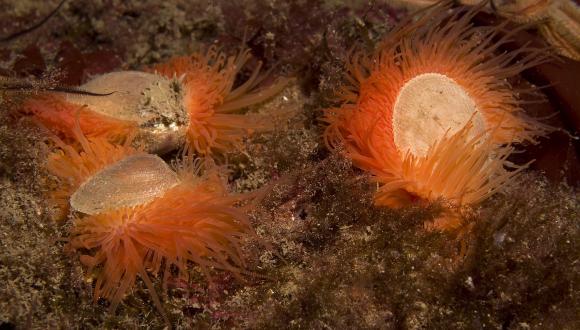
- Flame shell beds
- Horse mussel beds
- Maerl beds
- Maerl or coarse shell gravel with burrowing sea cucumbers
- Native oysters
- Northern sea fan and sponge communities
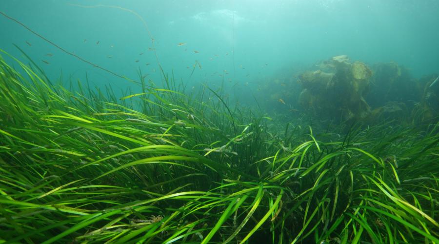
- Seagrass beds
- Serpulid aggregations
*Whilst cold water coral reefs were identified as one of the 11 there are no PMF management measures being proposed for this feature as we did not identify any key locations outside the current MPA network withing 6nm.
Why are the MPA and PMF workstreams joined?
The workstreams to implement fisheries management measures in MPAs and to safeguard PMFs from bottom-contacting mobile fishing gear were brought together in 2019. Officials identified several benefits from combining the proposed MPA management measures for fishing activity and the PMF process into a single consultation that would offer stakeholders a more holistic view of proposed measures. This is because 1) both workstreams were about management measures for fishing activity and 2) there was overlap in the areas of interest (whether close to an MPA or over a fishing patch) and so it made sense to deliver the work as one package to avoid duplication in discussions avoid over-complicating the process.
Will the proposed PMF management measures affect gear types such as creeling?
The proposed PMF management measures will only prohibit bottom-contacting mobile gear. No other fishing gear types are being considered in this process.
The proposed MPA management measures do consider all gear types and management will depend upon the interaction between the gear type and the protected features of the site.
How many MPA/PMF management areas in total will have management measures for fishing activity proposed in the planned consultation?
- NC MPAs – 11
- SACs – 21
- Marine SPAs – 44
- PMF management areas – approximately 90
What is the difference between this work and Highly Protected Marine Areas (HPMAs)?
Management measures for fishing activity are necessary in order to meet the requirements of the Habitats Regulations, the Marine Scotland Act (2010) and the commitments in the National Marine Plan. The management measures work started in 2014 – long before consideration of HPMAs.
The HPMA proposal aimed to provide a high level of protection by placing strict limits on a wide range of human activities. The proposed management measures for MPAs aim to manage specific fishing activities to meet conservation objectives under the principle of sustainable use of MPAs.
The proposal for HPMAs, as consulted on in 2023, is not being taken forward by Scottish Government.
Why do we need to protect burrowed mud habitats from trawling?
Burrowed mud habitats contain unique physical and ecological characteristics, such as the muddy sediment that settles in low-energy conditions and the species that are adapted to live there. Scampi or langoustines (Nephrops norvegicus) only live in these muddy sediments and create many of the burrows that are characteristic of this habitat, providing refuges for other species. Other species remain on the surface of the mud, such as sea pens and the fireworks anemone (Pachycerianthus multiplicatus). The different species that inhabit burrowed mud have different sensitivities to trawling, for example those inside burrows may be minimally impacted, while those on the surface may be removed by the fishing gear or, in the case of the tall sea pen (Funiculina quadrangularis), can have limited survival after becoming detached from the mud.
The species most sensitive to trawling pressures are likely to decline in numbers on fishing grounds, particularly where fishing intensity is high. Nephrops are only caught when on the mud surface, therefore those that remain in burrows (including all egg-carrying females) are minimally impacted – a behavioural adaptation that may contribute to Nephrops populations being able to withstand trawling. This means that even on productive fishing grounds where fishing is conducted in a manner that is sustainable for Nephrops stocks, other less-resilient species can still be damaged and reduced in numbers. As such, it is important that some burrowed mud is afforded protection from trawling to conserve the species found only in these habitats, in addition to areas where fishing for Nephrops can occur. Additionally, the fine sediment particles of the mud are particularly effective for storing carbon when undisturbed by trawling activity, making the protection of these habitats an important consideration when tackling climate change.
Questions about management
How are MPAs managed?
MPA management focuses on conserving/maintaining or recovering/restoring the protected features within a site. MPAs are considered to be multi-use locations that allow for sustainable use so that activities which do not impact the achievement of the conservation objectives can continue. It follows a precautionary approach where required .
Public authorities must ensure that the activities they regulate, permit or licence within NC MPAs cause no significant risk of hindering the achievement of the sites Conservation Objectives. This will be achieved by undertaking an MPA Assessment. Competent authorities should only give permission for a proposal within SACs and SPAs (European sites) after having ascertained that it will not adversely affect the integrity of the site. This will be achieved by undertaking a Habitats Regulations Appraisal.
NatureScot provides advice to support the management of activities, based on the sensitivity of the features, the level of exposure to activities and the overall risk to achieving the Conservation Objectives of the MPA. This advice is within our Conservation and Management Advice (CMA) documents which are available on Sitelink.
What are Conservation Objectives?
Conservation Objectives set out the desired quality of the protected features within each MPA and provide the framework for developing MPA management.
For Nature Conservation MPAs:
- Where evidence exists that a protected feature is in favourable condition then the conservation objective will be to ‘conserve’.
- Where limited evidence exists and therefore there is uncertainty about the condition of protected features (but no reason to suspect deterioration in condition since site selection), then the conservation objective will also be to ‘conserve’.
- Where evidence exists that a feature is declining and/or damaged and therefore is in unfavourable condition in the site, the Conservation Objectives will seek to ‘recover’ the protected feature.
For SACs and SPAs:
- Where evidence exists that a protected feature is in favourable condition then the conservation objective will be to ‘maintain’.
- Where limited evidence exists and therefore there is uncertainty about the condition of protected features (but no reason to suspect deterioration in condition since site selection), then the conservation objective will also be to ‘maintain’.
- Where evidence exists that a feature is declining and/or damaged and therefore not in a favourable condition in the site, the Conservation Objectives will seek to ‘restore’ the protected feature.
What management advice do we provide to support the achievement of the Conservation Objectives for the protected features of an MPA?
Our advice is focused on the activities that cause an effect (a pressure) that a feature is sensitive to and can be found in Table 2 “NatureScot’s advice to support management of activities…” in our Conservation and Management Advice documents. Pressures can be physical (e.g. abrasion of the seabed), chemical or biological. Our advice takes a risk-based approach, i.e. we are focusing on providing advice where we believe there is a risk to achieving the Conservation Objectives. We have identified risks to achieving the Conservation Objectives where there is an overlap between the protected features and activities associated with pressures that the features are sensitive to.
Our advice is based on existing data and information on protected features and the relevant activities, and our understanding of the relationships between the features and activities. We have identified a range of management advice:
• management to remove or avoid pressures
• management to reduce or limit pressures; or
• no additional management required.
For our advice on fisheries management, we have also stated where we think this should be ‘considered’ or ‘recommended’. The term ‘considered’ is included to highlight that a fishery-feature interaction exists, but circumstances mean that a specific recommendation for action cannot / or need not be made at this point. However, there is sufficient cause to make fishery managers aware and for them to consider if a fishery management measure may be helpful in achieving Conservation Objectives – particularly where there may be a synergy between the benefits of management actions for the fishery and the Conservation Objectives for the feature. The term ‘recommended’ highlights that an issue of fishery-feature interaction exists, there is a reasonable evidence base, and a specific recommendation can be made/ justified.
What evidence has been used to decide the proposed management measures for fishing activity in MPAs?
The proposed management measures are based on the best available knowledge about the protected features and the nature of the activities occurring within and adjacent to the MPA. This will include information on the distribution and condition of the features of the MPA, together with information on the sensitivities of the features. Information provided by fishers to the Marine Directorate has been used by them to help refine measures, allowing activity to continue in important fishing areas where it will not impact on the conservation objectives of the site.
Who has the final decision on what management measures are put in place?
Scottish Ministers make all final decisions on management measures that are implemented through Marine Conservation Orders and Inshore Fisheries Orders.
What exactly are the roles of NatureScot and Marine Directorate during this process?
The consultation is run by the Scottish Government’s Marine Directorate, who are the regulator for fisheries. NatureScot’s role is to set the Conservation Objectives for MPAs, provide advice to regulators on how to meet the Conservation Objectives of those MPAs and to provide advice on activities that may pose a risk to the national status of PMFs. Marine Directorate draft the management measures based on this advice, carry out the impact assessments and run the consultation. The final decision on the measures and their implementation is made by Scottish Ministers.
To summarise:
Marine Directorate
- Regulator for Fisheries
- Draft management measures considering advice from NatureScot, as well as their legal responsibilities
- Carry out the impact assessments
- Run the consultation
- Final decision made by Scottish Ministers
NatureScot
- Nature Conservation Body
- Set the Conservation Objectives for MPAs
- Provide advice to regulators on how to meet the Conservation Objectives of MPAs
- Provide advice on activities that may pose a risk to the national status of PMFs
Why do we need to restrict trawling and dredging on seabeds made up of sand and mixed sediments which are naturally disturbed by storms?
The populations of species that live on and within these sand and mixed habitats are naturally adapted to the frequency and seasonality of impacts caused by storms. Additional pressures, such as those caused by fishing activity, can increase the impacts on the species present. These pressures include removal of and damage to organisms. They also include increased energetic costs as a result of being damaged or disturbed which can result in loss of time feeding, reduced reproductive capacity and potentially decreased viability of populations to sustain themselves. Fishing pressure can also alter the structure of the seabed, making the sediment structure the same throughout and increasing the density of surface sediments (as summarised in Epstein et al., 2022).
The species characteristic of sediment communities are important in modifying the structure of sediments both on and beneath the surface. They increase the depth of oxygen penetration, which allows more organisms to live in the sediment and creates a healthier, more productive ecosystem. Habitats that have been damaged or disturbed can be recolonised relatively quickly by opportunistic species (e.g. Kaiser et al., 2006). However, the characterising burrowing bivalves of this habitat are likely to recover more slowly. Therefore, during recovery, the community may shift to one dominated by worms. Repeated disturbance may lead to an impoverished community, with a reduction in the diversity, abundance and biomass of species (Collie et al., 1997) as well as a restriction in the distribution of characteristic species.
Around our coasts, in particular locations, trawling and dredging activities can be frequent and occur year-round. Mechanical dredges typically penetrate 1–15 cm into sandy sediments, whereas otter trawls penetrate 0–2 cm (Eigaard et al., 2016). The initial impact of the first trawl over an area has been shown to have the greatest impact on biomass and productivity (Hiddink et al., 2006). Though the cumulative effect of repeated fishing activities over an area may leave populations in a more degraded state and may lower their resilience to dealing with other natural stressors, like storms.
In deep waters, the impact of storms can be less than in shallow waters, but the pressures caused by trawling and dredging pressure are the same irrespective of depth. This same principle applies to the relative impact of storms and bottom-contacting fishing activity in sheltered locations which have low natural disturbance. Seabed habitats and species have been shown to recover more quickly following extreme storms than from fishing activity (Sheehan et al., 2021).
Our advice to support management for these habitats where they are a protected feature, or part of one in an MPA, is to reduce or limit seabed trawling and dredging. This is based on the evidence around the sensitivity of these habitats which is presented in FeAST. The area of the feature to be protected should be large enough to sustain viable populations, should include representation of all the different types of seabed communities within these areas, and include consideration of areas with surface-dwelling species known to be particularly sensitive to abrasion. At least in some MPAs, there are likely to be options around how to reduce or limit pressures, and the solutions may be tailored to specific locations. We have recommended that Marine Directorate consider this when designing the measures for inshore MPAs.
The proposed management measures for fishing activity over sand and mixed sediment habitats will allow these habitats to exist in a more natural state where organisms have the potential to grow to full size and live longer and subsequently have greater reproductive capacity and productivity. As a result, the management measures will contribute to the resilience and recovery of populations within and outside the MPAs.
References
Collie, J. S., Escanero, G. A. and Valentine, P. C. (1997) Effects of bottom fishing on the benthic megafauna of Georges Bank. Mar Ecol Prog Ser 155:159–172
Eigaard, O.R., Bastardie, F., Breen, M., Dinesen, G.E., Hintzen, N.T., Laffargue, P., Mortensen, L.O., Nielsen, J.R., Nilsson, H.C., O’Neill, F.G., Polet, H., Reid, D.G., Sala, A., Skold, M., Smith, C., Sørensen, T.K., Tully, O., Zengin, M. and Rijnsdorp, A.D. (2016). Estimating seabed pressure from demersal trawls, seines, and dredges based on gear design and dimensions. ICES Journal of Marine Science, 73(Suppl. 1), pp. i27–i43
Epstein, G., Middelburg, J. J., Hawkins, J. P., Norris, C. R. and Roberts, C. M. 2022. The impact of mobile demersal fishing on carbon storage in seabed sediments. Global Change Biology Vol 28, Issue 9.
Hiddink, JG, Jennings, S, Kaiser, M. J, Queirós, AM, Duplisea, DE and Piet, G. J (2006) Cumulative impacts of seabed trawl disturbance on benthic biomass, production, and species richness in different habitats. Canadian Journal of Fisheries and Aquatic Sciences, 63 (4). pp. 721-736. ISSN 0706-652X.
Kaiser, M. J., Clarke, K. R., Hinz, H., Austen, M. C.V., Somerfield, P. J. and Karakassis, I. 2006. Global analysis of response and recovery of benthic biota to fishing. Marine Ecology Progress Series Vol 311: 1-14.
Sheehan, E. V., Holmes, L. A., Davies, B. F. R., Cartwright, A., Rees, A. and Attrill, M. J. 2021. Rewilding of Protected Areas Enhances Resilience of Marine Ecosystems to Extreme Climatic Events. Frontier in Marine Science.
Why was there a delay between the first round of MPA management measures for fishing activity and now?
Management measures came into place for the first cohort of priority MPAs in 2016 (8 SACs and 9 Nature Conservation MPAs). Since then, there have been delays in the work partly due to an expansion of the scope to incorporate the sensitive PMF management areas and newly designated MPAs, marine SPAs and colony extension SPAs as well as delays due to Covid-19.
Questions about evidence
Where can I access information on the evidence used?
Please refer to our consultation web page to find out more about our evidence and advice. Here you will find key documents along with useful explainer videos for our Conservation and Management Advice documents, PMF advice documents, Feature Activity Sensitivity Tool (FeAST), Fisheries Guidance Notes and other supplementary advice NatureScot has provided to Marine Directorate to inform the development of the measures.
Data can be found at the following:
National Marine Plan interactive (NMPi) - an interactive tool enabling access to spatial information relating to the marine environment and activities, designed to assist in the development of national and regional marine planning. NMPi allows you to view different types of information and, where appropriate, links have been provided to the related parts of Scotland's Marine Atlas and to the National Marine Plan.
GeMS - A collation of the known distribution of PMFs (species and habitats) and Annex I habitats collated by NatureScot and JNCC. GeMS is available on NMPi and NatureScot’s Open Data Hub and is the core evidence base of the MPA network and the PMF management areas.
Marine Recorder - A data management system that holds information on benthic habitats distribution, species abundance and distribution and associated metrics such as particle size analysis. Includes data from NatureScot JNCC, Marine Directorate SEPA, Seasearch and other citizen science initiatives. Collectively the data provides a baseline of information for Scotland's seas which can be used to identify habitats, species and areas of nature conservation importance and to assist with marine management is available for download. View
NatureScot Open Data Hub - Provides open access to NatureScot’s main spatial datasets as data downloads. Includes data such as MPA boundaries and GeMS (most of which can also be accessed through NMPi). View
Seabird Monitoring Programme (SMP) – Assesses the status of Britain and Ireland’s internationally important seabird populations by monitoring trends in their abundance and productivity at both coastal and inland sites. The SMP online database allows data on species abundance and breeding productivity to be viewed and downloaded.