SSSI denotification documents
Back to the Protected Area notices page
Ballyoukan Juniper Wood SSSI - partial denotification letter and map
Natural Heritage Protected Sites Team
Natural Resources Division
Environment and Forestry Directorate
Area 1-C North
Victoria Quay
Edinburgh
EH6 6QQ
Our ref: Sit/SSSI/Ballyoukan/Not
27 June 2019
Dear Sir/Madam
Ballyoukan Juniper Wood Site of Special Scientific Interest (SSSI) DENOTIFICATION UNDER SECTION 9(5) OF THE NATURE CONSERVATION (SCOTLAND) ACT 2004
SNH has reviewed the scientific interest of Ballyoukan Juniper Wood SSSI and decided that the part of the site marked on the enclosed map should not continue as an SSSI following the approvals of planning permissions by Perth & Kinross Council for the construction of a house and an adjacent garage. This is because the land is no longer of special interest due to the change to the land that has been caused by the construction of the house, garage and garden.
The denotification of this part of Ballyoukan Juniper Wood SSSI takes effect from the date of this letter.
If SNH is consulted after the date of confirmation by other bodies over operations, plans or projects affecting the land, SNH will respond in the same way as it would have done had the land not been notified.
Please contact Gwen Blyth at our Battleby office at [email protected] if you have any queries.
Yours faithfully
Denise Reed
Area Manager
Tayside & Grampian
Enc. Map showing the land to be denotified
New SSSI Map
New citation
Scottish Natural Heritage, Battleby, Redgorton, Perth PH1 3EW Tel: 01738 444 177 www.nature.scot
Dualchas Nàdair na h-Alba, Battleby, Ràth a' Ghoirtein, Peairt PH1 3EW Fòn: 01738 444 177 www.nature.scot
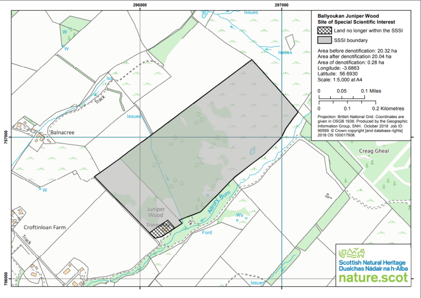
Ballyoukan Juniper Wood Site of Special Scientific Interest
Click for a full description
Map showing land no longer within the SSSI and also showing the SSSI boundary at Ballyoukan Juniper Wood. Area before denotification: 20.32 ha, Area after denotification 20.04 ha, Area of denotification: 0.28 ha, Longitude: -3.6863, Latitude: 56.6930, Scale: 1:5,000 at A4.
Projection: British National Grid. Coordinates are given in OSGB 1936. Produced by the Geographic Information Group, SNH. October 2018 Job ID: 90599. © Crown copyright [and database rights] 2018 OS 100017908.
Earlshall Muir SSSI - partial denotification letter and map
Scottish Government
Natural Heritage Protected Sites Team Natural Resources Division
Environment and Forestry Directorate
Area 1-C North Victoria Quay
Edinburgh EH6 6QQ
23 August 2019
Dear Sir/Madam
Earlshall Muir Site of Special Scientific Interest (SSSI) DENOTIFICATION UNDER SECTION 9 (5) OF THE NATURE CONSERVATION (SCOTLAND) ACT 2004
This letter is to inform you that we have denotified part of Earlshall Muir Site of Special Scientific Interest (SSSI). The area denotified is shown on the enclosed map. The remainder of the SSSI is unaffected and I enclose a copy of the revised citation and SSSI boundary map.
We made this decision as this area no longer contains the features of special interest. These were lost in 2003 following the development of essential infrastructure requirements for the expansion of the then Leuchars Air Base, now Leuchars Station.
The denotification of this part of Earlshall Muir SSSI takes effect from the date of this letter. Please contact David Shepherd at our Cupar office on 01738 458812 if you have any queries.
Yours faithfully
Ian Bray
Area Manager
Enc. Map showing boundary change
Revised citation
Revised SSSI Boundary map
Scottish Natural Heritage, Elmwood Campus, Carslogie Road, Cupar, Fife KY15 4JB Tel: 01738 458 800 www.nature.scot
Dualchas Nàdair na h-Alba, Àrainn Elmwood, Rathad Carslogie, Cùbar, Fìobha KY15 4JB Fòn: 01738 458 800 www.nature.scot
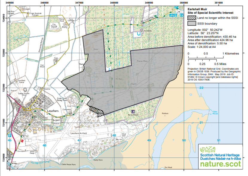
Earlshall Muir Site of Special Scientific Interest
Click for a full description
Map showing land no longer within the SSSI and the SSSI boundary at Earlshall Muir SSSI. Longitude: 002° 50.242'W, Latitude: 56° 23.257'N, Area before denotification: 430.46 ha, Area after denotification 424.96 ha, Area of denotification: 5.50 ha, Scale: 1:24,000 at A4.
Projection: British National Grid. Coordinates are given in OSGB 1936. Produced by the Geographic, Information Group, SNH. May 2019 Job ID: 91482. © Crown copyright [and database rights] 2019 OS 100017908.
Skolie Burn SSSI - partial denotification letter and map
Scottish Government
Natural Heritage Protected Sites Team Natural Resources Division
Environment and Forestry Directorate
Area 1-C North Victoria Quay
Edinburgh EH6 6QQ
1 November 2019
Dear Sir/Madam,
Skolie Burn Site of Special Scientific Interest (SSSI) DENOTIFICATION UNDER SECTION 9 (5) OF THE NATURE CONSERVATION (SCOTLAND) ACT 2004
This letter is to inform you that we have denotified part of Skolie Burn Site of Special Scientific Interest SSSI). The area denotified is shown on the enclosed map. The remainder of the SSSI is unaffected and I enclose a copy of the revised citation and SSSI boundary map.
We made this decision as the development of Burnside View in the 1990’s did not impact on the notified features of the site.
The denotification of this part of Skolie Burn SSSI takes effect from the date of this letter.
Please contact Michael Thornton at our Edinburgh office on 0131 3162628 if you have any queries.
Yours sincerely
Ian Bray
Area Manager
Enc. Map showing boundary change
Revised citation Revised
SSSI Boundary map
Scottish Natural Heritage, Silvan House, 3rd Floor East, 231 Corstorphine Road, Edinburgh EH12 7AT Tel: 0131 316 2600 www.nature.scot
Dualchas Nàdair na h-Alba, Taigh Silvan, 3mh Làr an Ear, 231 Rathad Chros Thoirphin, Dùn Èideann EH12 7AT Fòn: 0131 316 2600 www.nature.scot
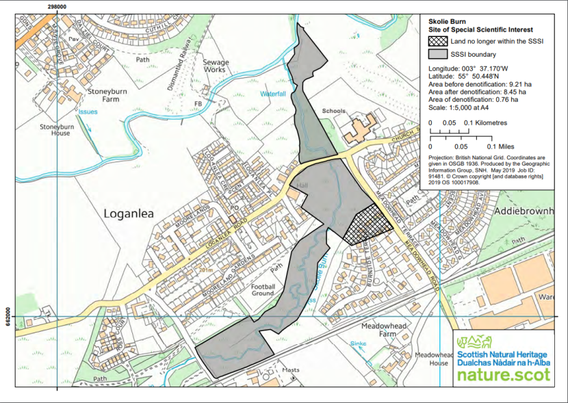
Skolie Burn Site of Special Scientific Interest
Click for a full description
Map showing land no longer within the SSSI and the SSSI boundary at Skolie Burn. Longitude: 003° 37.170'W, Latitude: 55° 50.448'N, Area before denotification: 9.21 ha, Area after denotification: 8.45 ha, Area of denotification: 0.76 ha, Scale: 1:5,000 at A4.
Projection: British National Grid. Coordinates are given in OSGB 1936. Produced by the Geographic Information Group, SNH. May 2019 Job ID: 91481. © Crown copyright [and database rights] 2019 OS 100017908.
Correen Hills SSSI - denotification letter and map
Natural Heritage Protected Sites Team
Natural Resources Division Environment and Forestry Directorate
Area 1-C North
Victoria Quay
Edinburgh
EH6 6QQ
Our ref: SIT/SSSI/Correen Hills/Not
9 June 2020
Dear Sir/Madam
Correen Hills Site of Special Scientific Interest (SSSI) CONFIRMATION OF DENOTIFICATION UNDER SECTION 9(1) OF THE NATURE CONSERVATION (SCOTLAND) ACT 2004
I write to inform you that Scottish Natural Heritage confirms the denotification of the above SSSI in accordance with the letter sent to you on 27 June 2019.
Yours faithfully
Denise Reed
Area Manager
Tayside & Grampian
Scottish Natural Heritage, Inverdee House, Baxter Street, Torry, Aberdeen AB11 9QA Tel: 01224 266 500 www.nature.scot
Dualchas Nàdair na h-Alba, Taigh Inbhir Dhè, Sràid Baxter, Torraidh, Obar Dheathain AB11 9QA Fòn: 01224 266 500 www.nature.scot
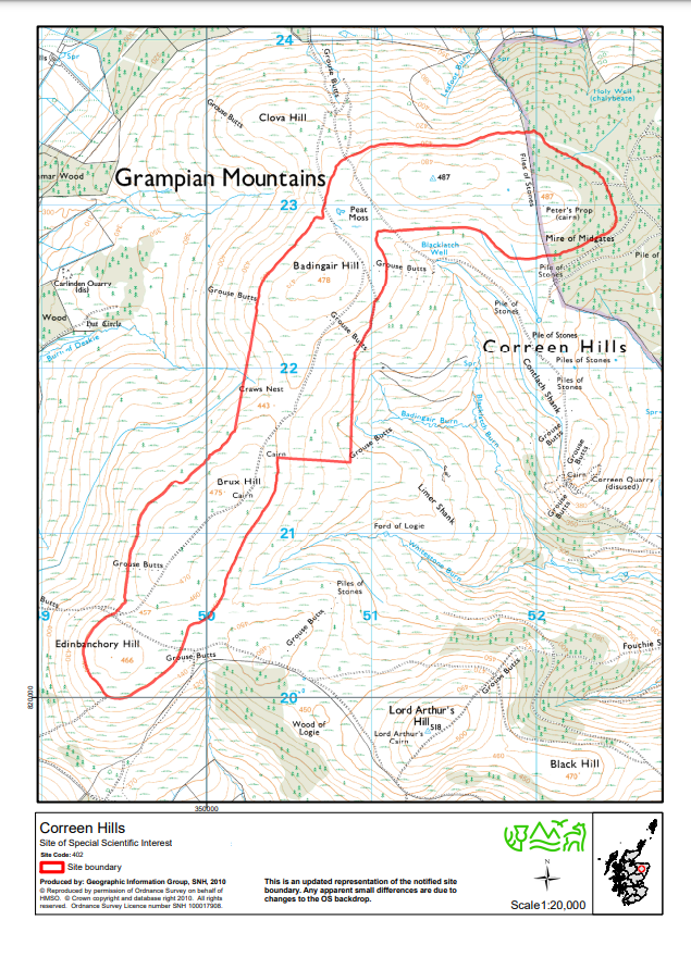
Correen Hills Map
Click for a full description
Map showing Correen Hills site boundary. This is an updated representation of the notified site boundary. Any apparent small differences are due to changes to the OS backdrop. Scale1:20,000,
© Reproduced by permission of Ordnance Survey on behalf of HMSO. © Crown copyright and database right 2010. All rights reserved. Ordnance Survey Licence number SNH 100017908. Produced by: Geographic Information Group, SNH, 2010 Site of Special Scientific Interest
Foveran Links SSSI - partial denotification letter and map
Forevan Links
Biodiversity and Land Quality Team
Natural Resources Division
Environment and Forestry Directorate
3G South
Victoria Quay
Edinburgh
EH6 6QQ
08 December 2020 Our ref: SIT/SSSI/Foveran Links/Not
Dear Sirs
Foveran Links Site of Special Scientific Interest (SSSI) DENOTIFICATION UNDER SECTION 9(1) OF THE NATURE CONSERVATION (SCOTLAND) ACT 2004
I write to inform you that Scottish Natural Heritage (also referred to as NatureScot) has considered representations and confirms the partial denotification of the above SSSI in accordance with the letter I sent to you on 27 June 2019. I have also enclosed a revised citation and map for the SSSI, which take effect from the date of this letter.
Yours faithfully,
Denise Reed
Area Manager
Tayside & Grampian
[email protected]
Enc. SSSI map, revised
SSSI map showing area denotified
SSSI citation, revised
Battleby, Redgorton, Perth PH1 3EW
Battleby, Ràth a' Ghoirtein, Peairt PH1 3EW
01738 444177 nature.scot
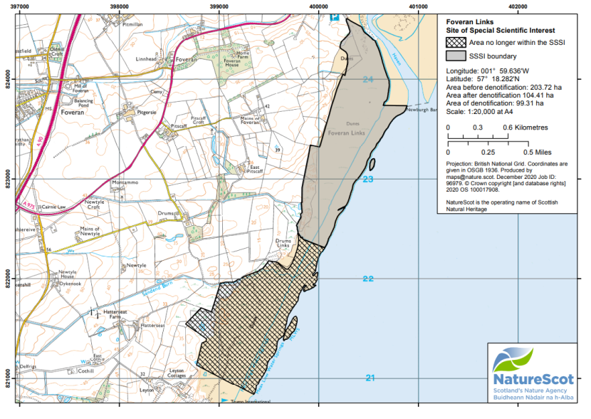
Foveran Links Site of Special Scientific Interest
Click for a full description
Map showing the area no longer within the SSSI and the SSSI boundary at Foveran Links. Longitude: 001° 59.636'W, Latitude: 57° 18.282'N, Area before denotification: 203.72 ha, Area after denotification 104.41 ha, Area of denotification: 99.31 ha, Scale: 1:20,000 at A4.
Projection: British National Grid. Coordinates are given in OSGB 1936. Produced by [email protected]. December 2020 Job ID: 96979. © Crown copyright [and database rights] 2020 OS 100017908.
Mollinsburn Road Cutting SSSI - partial denotification letter and map
Scottish Government
Natural Heritage Protected Sites Team Natural Resources Division
Environment and Forestry Directorate
Area 1-C North
Victoria Quay
Edinburgh
EH6 6QQ 04
February 2019
Dear Sir/Madam
Mollinsburn Road Cutting Site of Special Scientific Interest (SSSI) De-notification under Section 9(5) of the Nature Conservation (Scotland) Act 2004
SNH has reviewed the scientific interest of Mollinsburn Road Cutting SSSI and decided that part of the site should not continue as an SSSI because sections of three of the exposures were destroyed to accommodate the M80 upgrade undertaken between July 2009 and June 2011.
The de-notification of this part of Mollinsburn Road Cutting SSSI takes effect from the date of this letter.
This means that from now on if the owners wish to carry out any of the activities on the list of operations requiring consent on the area concerned they will no longer need to obtain consent from SNH.
Please get in touch with Peter Kelly at our Hamilton office on 01698 421668 or via email at [email protected] if you have any queries about this letter.
Yours faithfully
Kerry Wallace
Unit Manager
Scottish Natural Heritage, Cadzow Court, 3 Wellhall Road, Hamilton ML3 9BG Tel: 01698 421 668 www.nature.scot
Dualchas Nàdair na h-Alba, Cùirt Cadzow, 3 Rathad Wellhall, Hamilton ML3 9BG Fòn: 01698 421 668 www.nature.scot
Enc. SSSI Map showing land no longer within the SSSI
SSSI Map (updated)
SSSI Citation (updated)
List of operations requiring consent (ORC)
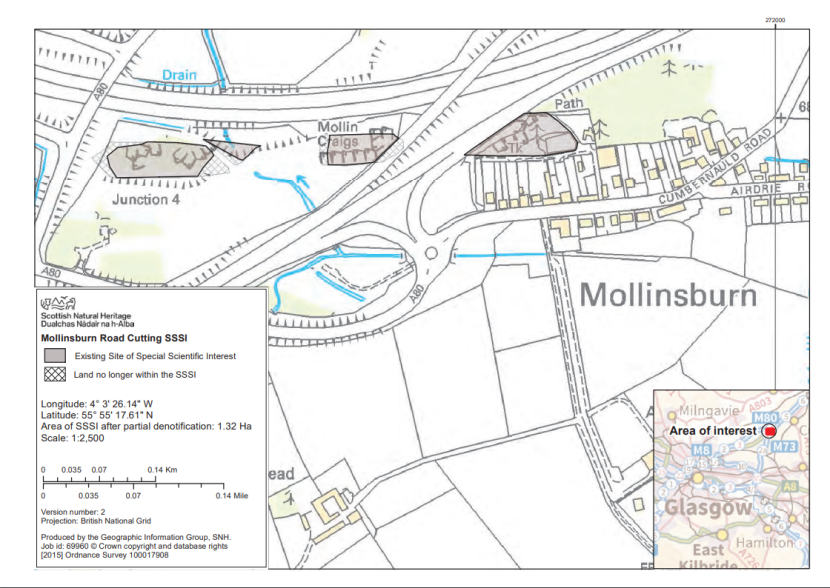
Mollinsburn Road Cutting SSSI
Click for a full description
Map showing Existing Site of Special Scientific Interest and Land no longer within the SSSI. Longitude: 4° 3' 26.14" W, Latitude: 55° 55' 17.61" N, Area of SSSI after partial denotification: 1.32 Ha, Scale: 1:2,500.
Version number: 2 Projection: British National Grid. Produced by the Geographic Information Group, SNH. Job id: 69960 © Crown copyright and database rights [2015] Ordnance Survey 100017908
Last updated: