Green Infrastructure Project Update - Park Life!
Glasgow still enjoys an after-glow from hosting the 2014 Commonwealth Games. One of many legacy projects to capture the affections of Glaswegians was the regeneration of the area around Cuningar Loop, home to a woodland park in a city that has always valued green spaces.
The site had previously played a significant part in Glasgow’s economic and social history. In the early nineteenth century it was home to reservoirs which fed the growing city, then in quick succession it was associated with quarrying, mining and, finally, as a convenient dumping site for demolished Gorbals housing. None of these industrial activities did the site any great favours, although the reservoir of the 1860s was a vital component of the city’s embryonic water supply system.
With such a chequered history it was clear that transforming a bruised and heavily-used location into a woodland park would be no mean feat.
But help was at hand and steered by the expertise of Forestry Commission Scotland the site became home to around 15,000 trees, various wildflower areas, as well as a series of paths that allowed locals and visitors alike to better enjoy the rebirth of this quiet bend on Glasgow’s iconic river. Slowly but surely grey turned to green as an industrial past was consigned to history.
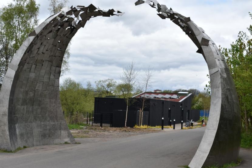
Cuningar Loop - Civic artwork marking entrance to the site.
Now the site is greening up rapidly and becoming something of a local star as a bold Phase Two project brings yet more of this area back into public use. The £3.16m extension promises to build on the good work already achieved.
Developing a further 7.67 hectares of vacant and derelict land will be no mean feat. Doing so whilst protecting existing biodiversity and ecology is even more challenging. But there is huge confidence that having come this far the team behind Cuningar Loop know how to navigate the challenges that will lie ahead.
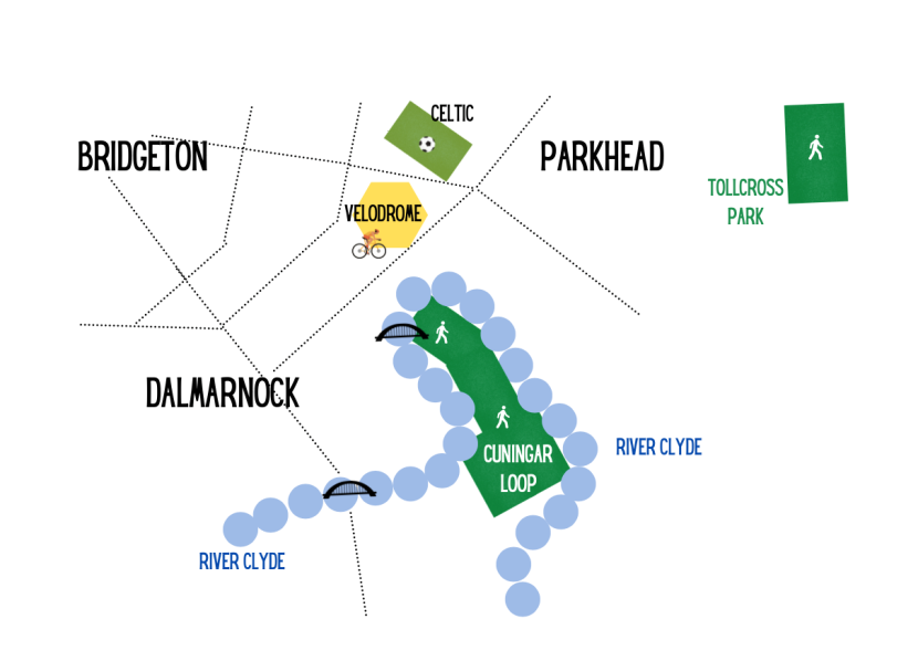
So where is Cuningar Loop ?
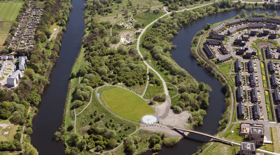
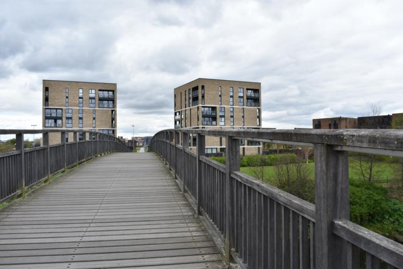
It sits south of the internationally famous Celtic Park and the popular Sir Chris Hoy Velodrome, tucked into a pronounced bend on the River Clyde. Appropriately a footbridge (see picture one) in a city famed for its bridges, allows the residents of Parkhead, Dalmarnock and Bridgeton to enjoy the traffic free park. Whilst, if you live in Rutherglen, you don’t even need to cross the river.
Cuningar Loop - Simple map showing site in relation to surrounding local Glasgow communities.
And who are the people driving this transformation?
Clyde Gateway provide the engine room behind what is one of Scotland’s biggest and most ambitious regeneration programmes. They are the glue that binds together a partnership including Glasgow City Council, South Lanarkshire Council and Scottish Enterprise, as well as funds and direct support from the Scottish Government, to ensure success.
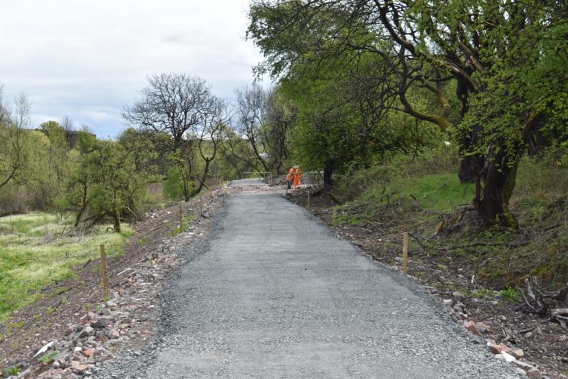
Cuningar Loop - Phase 2 work underway.
Dougie Cameron, an enthusiastic Project Manager at Clyde Gateway, showed me round the site and spoke of the journey that lies ahead and the considerable ground already covered in this area. “Phase One dates back to 2016.” he explained, “There are 12 hectares in the completed area, and Phase Two will add a further 8 hectares. Our people counters reveal good numbers visiting the site; over 500,000 since opening. The boardwalk lets people see the river here much more closely, enhances a really good walk around the site, but also helps ensure the wildlife lives here can better coexist with park users.”
The tranquillity you feel in the park is impressive. All the more so when you ponder on the fact that you are not too far from the busy M74 and the park truly sits amidst a fairly intensive city-scape. Within a mile or so there is a substantial population. Yet cross into Cuningar Loop and you quickly escape the stresses of city life.
As Dougie pointed out the site has wider appeal than the immediate locality. “ We recently we had an art engagement event, and were finding that visitors were coming from as far afield as Airdrie and Bathgate, looking for somewhere new to go with their families.”
“Some people have asked why we had a distinct Phase One and Phase Two approach. An overall masterplan for the area exists, but the approach was to break it into manageable chunks to make sure incremental and clear progress was visible. This has real benefits. Part of the justification for Phase Two is that Phase One was such a clear success, which in turn makes it easier to source additional and subsequent funding.
“Phase Two should be completed by Summer 2022 having started only in September 2021. Whilst Phase One was quite focussed on activities, Phase Two is more directed at biodiversity, enjoying nature, sensory experiences and opportunities to enjoy peaceful exercise in the park. The pedestrian bridge is a really important element, as it is key to providing access to the site from Dalmarnock, Bridgeton and Parkhead. It might look quite light and certainly has elegant lines, but it is underpinned by very substantial foundations. For most of the site, which is post-industrial, the approach has been to cap potential contamination, or where absolutely necessary to section off areas and deter access. Nothing was taken off the site, which cuts down the carbon footprint of the site’s creation.
“It might interest folk to know that the British Geological Survey are on site, using bore holes of 16m to 94m to research and monitor abandoned mine water in a search for more sustainable heat sources for buildings. In all they have four compounds here. Less scientific, but equally important it the ‘Bothy ‘building, which will be used for meetings and events. It’s a beautifully designed centre and will help diversify the offer of the site and increase its attraction for different types of visitors. It has all the facilities you would expect of a small business space and also includes public toilets. “
“A key difference in Phase Two will be that the grass will be different. Here there is much more emphasis on wildflower mixes rather than grass for recreational use. This is great for nature and also ensures a lesser maintenance burden. Rather than having to cut frequently like a traditional grassed play area it will only retire a cut or two each year. We will also have a pond and a raised educational zone as well as several woodland plots. As a teaching resource in which to learn more about nature the site has a lot to offer.”
Cuningar Loop is certainly finding a niche as an urban wildlife haven. On the day I visited the talk was of recent sightings of roe deer and otters, whilst overhead lumbering herons and a range of noisy gulls lit up the sky. Finches, blackbirds and thrushes made good use of the cover the greenery provided. It was clear that nature was eagerly seizing the opportunities the burgeoning park offers.
The Chief Executive of Clyde Gateway, Ian Manson, knows that a project of this scale will be warmly received locally. “Clyde Gateway has gained a deserved reputation for managing and delivering all sorts of high-quality projects over the past decade,” he notes, “Our track record shows we are very adept in making successful applications to a variety of funding bodies, many of which are making their first ever investments in our communities.
“This is certainly the case with the ERDF Green Infrastructure Fund and it is fantastic news that our two bids (a nearby project bid for Toryglen Park was also successful) have been supported with a sum which represents more than one-third of the total amount available for projects across Scotland.”
Projects of this ambition require large sums. But they equally demand large reserves of energy and expertise. Clyde Gateway is well placed to deliver what will be an exciting transformation. Something special is stirring in Glasgow’s East End.

NOTES
The Green Infrastructure Fund is part of the Scottish Government’s current European Regional Development Fund programme, which runs through to 2023. This is one of two ERDF Strategic Interventions led by NatureScot – the other is the Natural & Cultural Heritage Fund.
You can follow the European Structural Funds blog for ESF activities, news and updates. For twitter updates go to @scotgovESIF or use the hashtags #ERDF and #europeanstructuralfunds