The Management Plan for Caerlaverock National Nature Reserve 2016-2026
Foreword
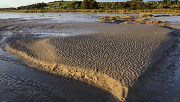
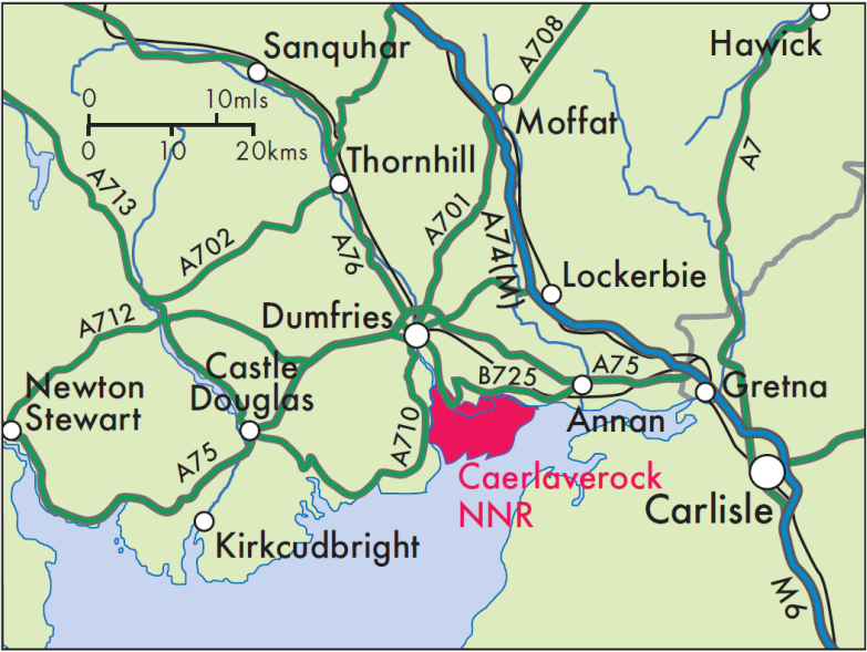
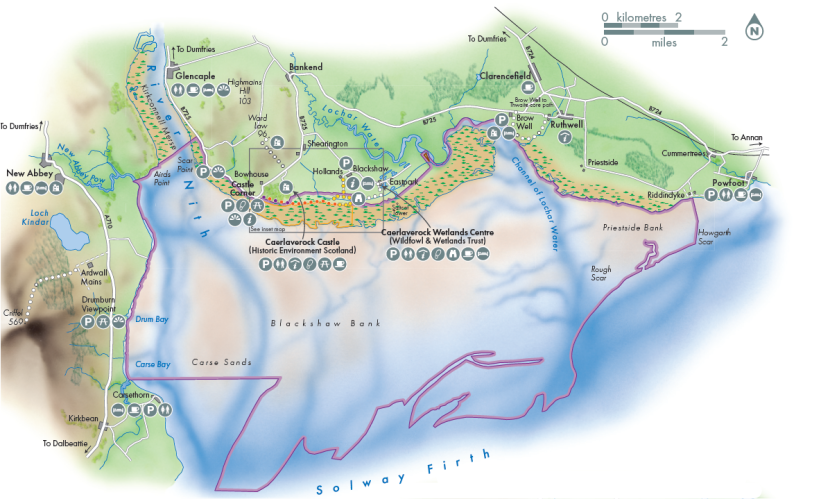
Caerlaverock National Nature Reserve (NNR) stretches for 16 kilometres along the north coast of the Solway Firth in Dumfries and Galloway, south west Scotland. There are few places like this in Scotland - a dramatic landscape of mudflats, sandbanks and saltmarsh, which extend beyond the reserve, into the estuary and all the way to England.
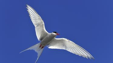
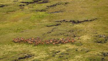
The reserve is home for tens of thousands of wintering barnacle geese; the entire Svalbard population of barnacle geese, currently approximately 40,000 birds, return each year to the Solway Firth. Winter also attracts staggering numbers of other wildfowl and waders, such as pintail, curlew and oystercatcher who flock here to feed on the mudflats and roost on the merse (local name for saltmarsh). Summer is quieter, but is also the time for the reserve's most unusual inhabitants to become active. In the shallow pools at the northern edge of the reserve, natterjack toads subsist at their most northerly location in the UK.
The saltmarshes are also notable for their landforms, which reveal processes of coastal evolution on an emerging coastline.
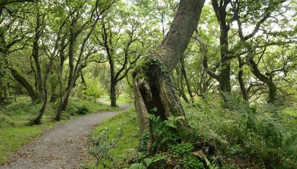
Visitors can access the reserve from Castle Corner and Hollands car parks. A path network links the access points on the reserve together. So visitors can choose between a short circular walk or follow a linear route through the reserve. Alternative access via Caerlaverock Castle to the core path which runs through the reserve can also lead visitors to the Wildfowl and Wetland Trust at East Park. There are also links with the path to Wardlaw where spectacular views are available. Together these provide many options for visitors to choose from.
Castle Corner has a viewing platform providing an ideal location to appreciate the spectacular landscape across the merse and the mudflats to Criffel. There can also be excellent views of the many birds which breed or over-winter here.
From Holland’s a circular route, with boardwalks, takes visitors through the Flooders onto the merse. A bird hide is accessible from the boardwalk providing a sheltered spot for viewing wildlife. This is an ideal spot to watch barnacle geese and egrets at high tide during the winter months.
At Castle Corner and Hollands car parks we provide maps, information and updates on the reserve.
Caerlaverock sits within a rich geographical and cultural landscape and this influences our management. The reserve is part of the Nith Estuary National Scenic Area which recognises the national importance of the landscape for communities and visitors alike. Adjacent to the reserve are the major visitor attractions of Caerlaverock Castle, managed by Historic Environment Scotland and Caerlaverock Wetland Centre managed by the Wildfowl and Wetland Trust. Together these sites combine to create a significant tourist destination. We will continue to look for opportunities to work in partnership with others to deliver our management plan within this wider context.
Caerlaverock is one of a suite of NNRs in Scotland. Scotland’s NNRs are special places for nature, where some of the best examples of Scotland’s wildlife are managed. Every NNR is carefully managed both for nature and for people, giving visitors the opportunity to experience our rich natural heritage.
'The Story of Caerlaverock National Nature Reserve' is a companion publication which has more information about Caerlaverock NNR and its history. For those wishing to understand more about the management of this very special place we recommend reading the Story.
In 2015, we carried out a review of our last Plan for Caerlaverock NNR (2009-2015). We used this, together with management plan workshops and specialist advice, to develop our future management proposals and inform the preparation of a draft Management Plan for 2016-2026. Having consulted on the plan we have now revised and finalised the plan.
The first section of this Plan gives our vision for Caerlaverock, describing how we would like to see the reserve in 2041. It specifies our objectives for management and outlines projects planned to deliver these objectives.
During the final year of the plan, we will review our progress against this plan to determine the future direction of our management on the reserve.
1. Our Vision for Caerlaverock NNR
Our vision for Caerlaverock NNR describes how we would like the reserve to be in 2041. This is a special place and we aim to keep it that way; this plan sets out how we will work towards achieving our vision.
Caerlaverock is a key attraction in Dumfries and Galloway offering an internationally important wildlife spectacle. Visitors are drawn here to experience this wild and open landscape, enjoy the winter spectacle of thousands of geese, waders and wildfowl or the summer sounds of skylarks, songbirds and natterjack toads. The reserve offers all year round interest with easy access to explore and get first-hand experience of this amazing place.
People are proud of Caerlaverock NNR and it is a focus for environmental, social and economic activity with local communities, key partners and communities of interest. Together with Caerlaverock Castle and Caerlaverock Wetland Centre the reserve provides a destination for visitors and locals; combined they deliver an excellent visitor experience.
Local people are regular visitors and value the role Caerlaverock has as a focal point for the Nith estuary and the wider Solway Firth. Many take a more active role volunteering on the reserve; helping out with practical management, contributing to our monitoring programme and the promotion of the reserve and the National Scenic Area.
Caerlaverock continues to be an important part of the extensive coastal system of the Solway Firth. The dynamic landscape of estuary, sandbanks, saltmarshes and brackish fen continues to evolve shifting and changing through natural processes.
The habitats are maintained to maximise the conditions for wildlife. Caerlaverock is a natural laboratory for specialist research and long-term monitoring which helps us to understand, predict and mitigate the impacts of climate change and sea level rise on a soft coast.
The reserve is a showcase for sustainable management; reserve staff work in partnership with others to ensure wildlife co-exist in harmony with cultural and economic land uses to generate multiple benefits to the wider area.
This well managed site continues to attract an internationally important assemblage of wintering wildfowl and waders. Significant numbers of barnacle geese, the majority of the over-wintering population from Svalbard, feed and roost undisturbed on the merse and mudflats.
Waders breed successfully on the merse, along with smaller song birds like skylark.
The natterjack toad population is stable due to sympathetic management.
Populations of rare and localised plants and invertebrates have expanded as a result of the pro-active management on the merse and Flooders.
2. Protected areas and features
Caerlaverock was first declared a NNR in 1957 under a Nature Reserve Agreement (NRA) with the Duke of Norfolk, owner of Caerlaverock Estate. SNH has extended the reserve 4 times and it now covers approximately 8,000 hectares (ha).
Caerlaverock is designated for its wildlife interest at UK, European and international level. It falls within the larger Upper Solway Flats and Marshes Site of Special Scientific Interest (SSSI), Special Protection Area (SPA), the Solway Firth Special Area of Conservation (SAC) and Ramsar site. The reserve also forms part of the Nith Estuary National Scenic Area (NSA).
Whilst managing Caerlaverock NNR we also have to take account of our legal obligations and Government policy to manage the features that are listed as important in a European or international context. Where a proposal may affect one or more of the qualifying interests of the SAC or SPA, we will carry out an ‘appropriate assessment’. This includes all projects, whether they are direct habitat management or providing a new visitor facility on the Reserve. We will only proceed with projects that do not adversely affect the interests. Likewise, we will also take account of obligations to manage features that are valued as important in a UK context, as well as features that are locally important.
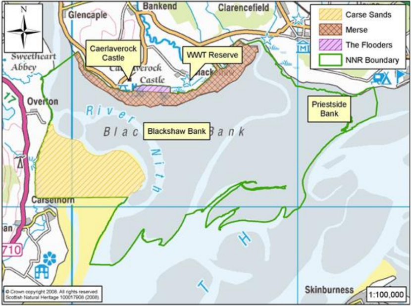
3. Location and boundary maps
4. Natural Heritage Management
Objective NH1: Manage the merse and inter-tidal habitats, allowing natural processes of coastal change to occur.
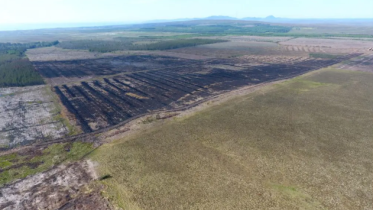
Natural processes over which we have no control shape and modify the majority of the merse and inter-tidal habitats. The constant ebb and flow of tide and the flow from the River Nith move the sands and muds across the reserve creating an ever changing habitat. We do manage the more stable areas of the merse to maintain conditions suitable for the bird interest and describe this in objective 2.
Our management here is limited to contain the spread of invasive cord grass (spartina spp.) a potentially invasive species that occurs where the mudflats meet the merse and ensuring that other works do not impact on the merse. We encourage cattle grazing and monitor stock density occupation on the merse to ensure habitats remain in good condition and that they are not poaching the ground at specific points as this may lead to erosion.
We monitor the features in this area as part of a national programme and complete further monitoring of key species which are indicators of change in the conditions.
|
Task No. |
Task description |
|---|---|
|
NH1.1 |
Control Spartina spp. expansion to ensure that natural coastal processes and species composition are maintained. |
|
NH1.2 |
Monitor grazing impact on ground condition and vegetation to ensure that natural coastal processes of drainage, erosion and deposition. |
|
NH1.3 |
Contribute to the national programme of Site Condition Monitoring for pioneer salt marsh, lower Atlantic saltmarsh mid-merse, Atlantic salt meadow habitats and glasswort & other annuals. |
|
NH1.4 |
Monitor extent of key plant quality indicators and vascular plant assemblage. |
Objective NH2: Support internationally important populations of geese, waders and wildfowl.
The intertidal areas provide a rich resource for feeding waders and wildfowl. Wildfowl favour the more stable areas of merse where vegetation cover is established and provides suitable grazing habitat.
The most important tool for managing the merse is grazing with cattle. The grazing helps to maintain the diversity of flora on the merse preventing vegetation becoming rank. The barnacle geese and other wildfowl favour the short sward height created by livestock grazing for winter feeding.
With the co-operation of local farmers it is possible to manipulate the length of the grass sward by changing levels of grazing by stock, mainly cattle. Inevitably it is difficult to achieve the same grazing levels over the whole of the merse, either because of ground condition or stock availability. We also need a grazier to manage the stock and move them according to the highest tides.
The Wildfowl and Wetlands Trust (WWT) has an agricultural tenure for part of the National Nature Reserve. They manage this part of the reserve to provide grazing for geese and other wildfowl such as wigeon in the winter usually sub-letting it to a grazier to achieve the right conditions.
Monitoring is important to check that bird populations are benefitting from the management of the merse and surrounding fields managed as part of the goose management scheme. We monitor breeding and wintering bird numbers. The data enables us to meet reporting needs for the feature of interest. We also provide data to a number of national and international monitoring programmes studying long-term trends in bird numbers.
We will continue to carry out site condition monitoring of all the internationally and nationally important bird species, and the more detailed monitoring required to inform us directly about our management.
|
Task No. |
Task description |
|---|---|
|
NH2.1 |
Monitor the internationally and nationally important wintering assemblages of waterfowl and contribute to WeBS and other national and international co-ordinated monitoring. |
|
NH2.2 |
Maintain the merse sward in suitable condition for geese, wildfowl and waders through advising on and encouraging appropriate levels of grazing. |
|
NH2.3 |
Monitor sward height to assess effectiveness of grazing. |
|
NH2.4 |
Monitor ground occupation of wintering birds on the merse to ensure grazing levels are maintaining an appropriate sward height. |
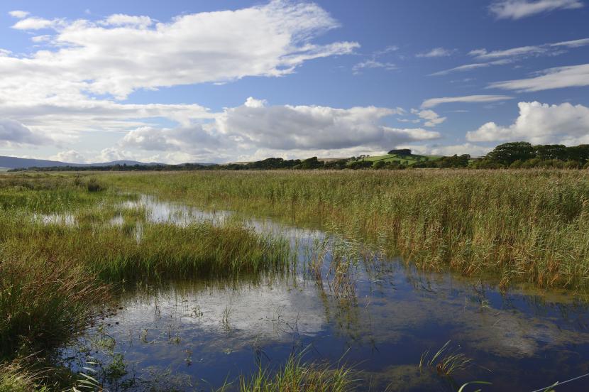
Objective NH3: Manage the Flooders to maintain the transition from salt to freshwater and sustain biodiversity.
The Flooders is a 32 ha marsh at the landward edge of the reserve, created in part by the construction of a sea bank in 1840 in an attempt at land reclamation. The area shows a transition from freshwater through a more brackish area into salt water.
There are indications that the conditions in the Flooders are changing – the reedbeds are spreading, there have been increased incidences of seawater in inundation into this area and the vegetation is apparently closing up and becoming denser. We will look into options for how we should manage this area in future. This may include focusing on certain aspects such as controlling the area of reed, taking a more proactive role in managing water levels. Or we may decide it is best to allow the current processes to take its course. Before we can make these decisions we need to have a better understanding of the current distribution of species and water movement around the Flooders.
In the longer term if sea levels rise as a result of climate change it is possible that the freshwater marsh will revert to merse or even mudflats. In this event we may need to look at how to form new freshwater and brackish water habitats further inland to maintain this important habitat and the species that depend on it.
|
Task No. |
Task description |
|---|---|
|
NH3.1 |
Conduct appropriate vegetation surveys during the management plan period to inform management on the Flooders. |
|
NH3.2 |
Manage water levels within appropriate parameters to maintain brackish and freshwater marsh transitions and discrete habitats. |
|
NH3.3 |
Manage reedbed habitats, including water levels and distribution, to encourage botanical, invertebrate, breeding and wintering bird interest. |
|
NH3.4 |
Monitor salinity by implementing both regular assessments and recording the impact of occasional sea water ingress. |
|
NH3.5 |
Monitor hydrology of the Flooders by recording water table and water level. |
|
NH3.6 |
Survey & monitor quality indicators (key plant species) found on the Flooders at least once the duration of the management plan. |
|
NH3.7 |
Create and manage pools and scrapes within the Flooders to support breeding waders where appropriate. |
Objective NH4: Collate information on key species and biodiversity to inform management of the reserve and manage habitats for other interests accordingly.
Wildfowl and waders represent the most significant species that use Caerlaverock. These are present on different parts of the reserve throughout the year. Some of them feed or roost on the mud flats and sandbanks while others breed in the summer or seek refuge on the merse during high tides along the winter months.
In order to maintain the ecological balance on the NNR, we use the different designations that are in place to prevent disturbance to the many species that live on the reserve; we also encourage appropriate levels of grazing to control the vegetation.
We will look for opportunities to make links between habitats across the reserve. Many are isolated pockets which make it difficult for species to spread or move between them. By creating corridors or extending areas we could improve the conditions for some species and make them more robust to changing conditions.
The population of natterjack toads at Caerlaverock is the most northerly population in the UK. The toads require very specific conditions to survive: they need shallow pools that dry out in the summer for breeding. This drying out, combined with occasional sea water inundation, helps to kill off potential predators such as, fish and larger aquatic invertebrates – which would otherwise eat the toads’ eggs and tadpoles. The toads also need a short sward adjacent to the pools for hunting, and refuges for shelter.
We will continue to manage the merse traditionally to maintain conditions for the toad including taking opportunities to create new pools, or re-profile existing ones, on the reserve and in the surrounding area. Cattle help maintain an appropriate sward height and keeping pools open but we need to balance this with ensuring they don’t poach the edges of the pools. We will, if necessary, use electric fencing to prevent this. We will also provide artificial refuges for the toads in strategic positions.
We will monitor the habitats for and populations of natterjack toads to assess the effectiveness of the management we will put in place.
The tadpole shrimp is another rarity found here. The maintenance of shallow pools in areas grazed by cattle will benefit the tadpole shrimp. We will monitor the pools annually for signs of tadpole shrimp though its occurrence is sporadic.
Working with volunteers we will expand the programme of monitoring we do on the reserve. Improving our knowledge of the species on and around the reserve will enable us to manage for a wider range of species and to identify opportunities to benefit them.
|
Task No. |
Task description |
|---|---|
|
NH4.1 |
Manage habitats for other species to sustain and improve overall biodiversity; including expansion of habitat, creating wildlife corridors to connect habitats and increasing available shelter. |
|
NH4.2 |
Review natterjack toad habitat management and implement any changes required to encourage expansion and counter impacts of climate change coordinating work with adjacent areas. |
|
NH4.3 |
Maintain the merse and pools to improve conditions for natterjack toads. |
|
NH4.4 |
Monitor natterjack toad populations to inform future management. |
|
NH4.5 |
Monitor and maintain suitable habitat for strandline and freshwater invertebrates. |
|
NH4.6 |
Manage pools to create suitable conditions for tadpole shrimp's and encourage expansion of their range by providing suitable habitats to reduce impacts of climate change. |
|
NH4.7 |
Monitor pools on the high merse-Flooders fringe for presence of tadpole shrimps. |
|
NH4.8 |
Monitor breeding and wintering bird populations. |
|
NH4.9 |
Encourage breeding waders and other key bird species such as skylark by managing habitats for them. |
|
NH4.10 |
Prevent the introduction, control, and where possible eradicate invasive non-native species (INNS) in accordance with local and national action plans. |
|
NH4.11 |
Limit competition from the spread of dominant species (gorse & reed) during the management period to protect nationally scarce species such as holy grass, tubular water-dropwort and others. |
|
NH4.12 |
Establish invertebrate baseline data of the Flooders including dragonflies, Lepidoptera, arachnids and Diptera. |
|
NH4.13 |
Encourage volunteers to assist with monitoring species of interest. |
Objective NH5: Promote Caerlaverock as a natural laboratory where geomorphology and the impact of climate change can be studied to inform planning and development activities on the NNR, elsewhere along the Solway and farther afield.
Caerlaverock is in an excellent position to encourage and support research and long term monitoring on both habitats and species. The reserve and adjacent areas also have potential for research on saltmarsh sediments and on sea level change and coastal evolution.
We will continue to encourage individual projects by students and university researchers, especially where these have direct relevance to our management of the reserve.
Over the period of the plan we will work with partners and volunteers to improve our knowledge of the changes occurring in the coastal habitats on the reserve. We will set out a research, survey and monitoring plan to help guide those using the site for these purposes. This will include a desire to better map physical changes in accumulation, accretion and erosion. We do not have resources or skills in house to undertake elements of this work so we will look to work with researchers or students to take this forward. We will share data collated with wider research programmes on coastal change and the impacts of climate change.
|
Task No. |
Task description |
|---|---|
|
NH5.1 |
Define protocol to monitor the physical extent of the pioneer, lower Atlantic saltmarsh and mid merse. |
|
NH5.2 |
Compile, review and update the list of relevant quality indicators to inform research projects on the reserve. |
|
NH5.3 |
Gather information on existing schemes run on the Solway and further afield to set and update the list of Quality Indicators that can be monitored on the reserve. |
|
NH5.4 |
Define baseline assessment of the mid merse (possibly mapping using LiDAR/ vertical accumulation). |
|
NH5.5 |
Contribute to defining a 3D Model by initiating & supporting baseline survey (mapping & vertical accumulation) liaising with key partners. |
|
NH5.6 |
Run regular monitoring and event-based survey of sandbanks and mudflats using remote sensing techniques involving volunteers where possible. |
|
NH5.7 |
Map the extent of merse and implement regular assessments and event based survey to monitor vertical accumulation, accretion and erosion of the merse involving local volunteers. |
5. Management for People
Objective VM1: Support fishing, wildfowling and farming interests by promoting best practice and sustainable use of the natural resources.
The reserve does not exist in isolation; it is part of a wider community of interests who utilise the natural resources the area provides for fishing, farming and wildfowling. We will continue to work in partnership to ensure that we manage the range of interests in balance with our requirement to protect the internationally important populations of species on the reserve.
We will continue to work closely with Marine Scotland and any regulated fishery to assess the impact of fishing activities on the features of the reserve (and wider estuary). This should enable the fishery to continue at a level which is not detrimental to the features.
Working closely with partners (Nith Catchment Fishery Trust, the River Annan Trust and Caerlaverock NNR landowners) we will advise on other types of fishing such as haaf netting and stake nets. These are organised through agreements with landowners, to ensure the activities are sustainable, and do not disturb the wildlife of the reserve. We hold the rights to stake netting on part of the reserve and will not implement this activity unless a sustainable proposal is made.
The wildfowling permit scheme set up on the reserve is still effective. We will continue to manage the scheme, working with Caerlaverock Estate, the British Association for Shooting and Conservation (BASC) and wildfowlers to ensure we can continue to meet the needs of the wildlife, the sporting interests and other visitors’ interests.
As part of the wildfowling scheme we will continue to monitor the wildfowling activities to determine the effectiveness of the scheme, and to ensure that wildfowlers are pursuing their interests appropriately and adhering to the requirements in the permit scheme.
We will liaise with local farmers to promote and improve grazing practice on the reserve to sustain management efforts and contribute to the local economy.
|
Task No. |
Task description |
|---|---|
|
VM1.1 |
Work with Marine Scotland to do fish stock assessments and support works to implement sustainable fisheries where feasible. |
|
VM1.2 |
Work with the Nith Catchment Fishery Trust, the River Annan Trust and Caerlaverock NNR landowners to help manage other forms of fishery and promote best practice on and around the reserve. |
|
VM1.3 |
Organise, chair and provide the secretariat for the Panel Meeting of the wildfowling permits scheme. |
|
Task No. |
Task description |
|---|---|
|
VM1.4 |
Manage the wildfowling permit scheme taking the advice of the Caerlaverock Panel on wildfowling in line with the Caerlaverock Estate NRA. |
|
VM1.5 |
Work with landowners, BASC and wildfowlers to promote best wildfowling practice on and around the reserve. |
|
VM1.6 |
Encourage delivery of grazing on the merse throughout the reserve. |
|
VM1.7 |
Work in partnership with DGC, SFP, the Fishery Trusts and Caerlaverock NNR landowners and others to help manage other forms of fishery and promote best practice on the reserve, the Nith Estuary and the wider Solway. |
Objective VM2: Enable a wide range of visitors to experience and enjoy the open landscape and wildlife of Caerlaverock by providing access and information.
Caerlaverock is an amazing natural heritage site with year round interest which we want to enthuse people about. Our focus is to enable a ‘wild nature’ experience for visitors.
We will continue to monitor visitor numbers to the reserve and we will complete visitor surveys to find out what people value about the reserve and where they believe there is need for improvements to enhance their experience. We will use the outputs from this to refresh the VMP to guide our future management for visitors. We will work with partners, in particular on neighbouring properties, to ensure a cohesive approach to visitor management is in place on and around Caerlaverock.
We will focus on improving visitors experience by upgrading sections of path on the reserve and refreshing the information available both on and off-site. All of the existing information on site needs reviewed and we will use this as an opportunity to improve it. We will also increasingly look to use social media to inform visitors.
|
Task No. |
Task description |
|---|---|
|
VM2.1 |
Working closely with Caerlaverock Estate, WWT and HES to deliver an onsite and off-site perception survey to assess scope for improvements to visitor facilities and information. |
|
VM2.2 |
Working closely with Caerlaverock Estate, WWT, HES, D&G Council and community councils and associations to revise and implement the Visitor Management Plan. |
|
VM2.3 |
Deliver actions identified in the VMP to provide a good quality visitor experience on the reserve and work with partners on neighbouring properties and in the surrounding area to provide a joint visitor experience. |
|
VM2.4 |
Upgrade access provision in accordance with the VMP within the reserve, and provide vantage points at key locations noting options for links with core paths in the area. |
|
VM2.5 |
Upgrade the provision of information signage and orientation including via social media based on agreed themes (i.e. natural and cultural heritage). |
|
VM2.6 |
Monitor visitor numbers and record feedback during engagement events and use the feedback to inform revisions to the Visitor Management Plan. |
Objective VM3: Increase awareness, use and involvement to promote the reserve and the National Scenic Area to the local community.
We see the NNR as having a role in inspiring visitors to the area. We would also like to see more visitors exploring the reserve and the wider area. Promotion and direct engagement are essential elements in increasing visitor numbers and encouraging wider support. We will produce a communication plan to guide us; ensuring we communicate with existing audiences, keep people up to date and encourage new and repeat visitors. We will use a range of media for communicating with different audiences.
While static information can reach high numbers of visitors and is available at all times we also recognise the value of direct engagement. We will offer a programme of events to promote both the natural and cultural features of Caerlaverock. Events will engage with both local audiences and visitors from further afield.
We will explore ways of building a complimentary experience to the ones already provided by our partners. We will look for opportunities to work in partnership and to promote the Caerlaverock experience. We will look at ways of communicating and promoting common themes and messages about the reserve and the Nith Estuary National Scenic Area (NSA) within which it is situated.
We will look at ways of building up relationships with local schools, in particular Kirkbean, Caerlaverock and New Abbey primary schools, by engaging with and supporting teachers in developing outdoors skills and by offering school visits by reserve staff and through Reserve open days.
We will offer opportunities for further education placements by developing partnership with local High schools, Scotland's Rural College (SRUC), The Conservation Volunteers (TCV) and other appropriate bodies.
We would like to extend our current volunteer programme and encourage more local volunteers to join in either on a regular basis or for specific projects. We will provide a range of volunteering including practical tasks and monitoring. We will continue to support volunteer groups looking to do projects. We will encourage hard-to-reach group to use the reserve.
|
Task No. |
Task description |
|---|---|
|
VM3.1 |
Review the reserve Communication Plan producing a clear set of outcomes and defining recommendations for Promotion and Engagement activities for local people. |
|
VM3.2 |
Promote the reserve off- site and online using social media, newsletter contributions, media releases and publications. |
|
VM3.3 |
Offer a programme of events promoting the unique natural and cultural heritage. |
|
Task No. |
Task description |
|---|---|
|
VM3.4 |
Run training events tailored to targeted audience (teachers, PAW members, volunteers, tourism businesses, wildfowlers, local people etc.) focussing on Caerlaverock natural & cultural heritage themes. |
|
VM3.5 |
Organise & contribute to specific SNH lead SGP events on community partnerships to raise awareness of partnership framework opportunities (such as Leader, etc.) and inspire community led initiatives around Caerlaverock. |
|
VM3.6 |
Working closely with Caerlaverock Estate, WWT, RSPB, DGERC and HES to support outdoor learning and encourage targeted audience (Primary School, youth clubs etc.) to visit and use the reserve. |
|
VM3.7 |
Provide school and further education placements by developing partnership with local High schools, Scotland's Rural College (SRUC), The Conservation Volunteers (TCV) and other appropriate bodies. |
|
VM3.8 |
Deliver voluntary work parties involving targeted groups (communities of interests). |
|
VM3.9 |
Recruit and provide training and work planning for long-term volunteers to support reserve activities. |
|
VM3.10 |
Participate in wider Scottish Solway projects to encourage & support other organisations and local people to monitor bird numbers through regular and frequent counts. |
Objective VM4: Increase awareness and understanding of the rich natural and cultural heritage and enthuse our local partners, tourism promoters, tourism businesses and wider communities of interest to deliver a world class Caerlaverock Experience.
Caerlaverock’s unique landscape is recognised nationally and strongly underpins local communities’ identity. The landscape where the reserve sits is the product of the influence of man over natural processes that shaped the land we inherited and the land we will pass on to the next generations. We want communities to influence the future changes at Caerlaverock to ensure the best outcomes for future generations.
In order to develop Caerlaverock’s potential to generate direct and indirect benefits to people who live in the area and beyond, we have to consider the broad range of interests that are served by the site. Specific projects will have to be implemented with others to create and sustain longevity.
During the course of this management plan, we will engage with, encourage and support individuals and communities to deliver joint projects on and around the reserve so people can appreciate, value, enjoy, promote and contribute to ‘Caerlaverock Experience’ and the uniqueness of the wider area.
|
Task No. |
Task description |
|---|---|
|
VM4.1 |
Work with partners and businesses to promote the reserve, the Nith Estuary NSA and the wider Solway Firth and encourage nature-based tourism within the area. |
|
VM4.2 |
Explore opportunities to take part in funded partnership programmes especially focused on climate change and natural coastal flood management or coastal ecosystem services. |
|
VM4.3 |
Define and set up a twinning partnership with another European protected site to highlight the international relevance of the 'Caerlaverock Experience'. |
|
VM4.4 |
Develop, organise & deliver a European scale project with 'Caerlaverock Experience' partners. |
|
VM4.5 |
Continue development of a world class destination within the region and encourage nature-based tourism on the reserve, the Nith Estuary NSA and the wider Solway Firth. |
6. Property Management
Objective PM1: Manage the reserve property responsibly following best management practice.
We manage the infrastructure and do regular maintenance and health and safety checks. All equipment used on site is maintained and conforms to the appropriate regulations.
|
Task No. |
Task description |
|---|---|
|
PM1.1 |
Maintain all visitor infrastructures (trails, car park, toilets, viewpoint etc.) in good condition for visitors. |
|
PM1.2 |
Carry out quarterly safety and condition assessments of all visitor infrastructures and keep accurate records. |
|
PM1.3 |
Ensure property and equipment is maintained and conforms with Health & Safety Regulations including risk assessment and fire plan reviews. |
|
PM1.4 |
Ensure payments made for Nature Reserve Agreement and other annual payments. |
7. Planning and reporting
Objective PR1: Planning & reporting: Ensure management planning is adaptive and effective.
The reserve plan provides valuable continuity however it is only part of the process and will be monitored and reviewed on an on-going basis with formal milestones at regular intervals.
An interim review will be completed mid-plan unless there are significant changes that require an earlier review. We will review the plan in the final year to inform preparation of the next management plan.
|
Task No. |
Task description |
|---|---|
|
PR1.1 |
Update annual budget in Q3 for bidding. |
|
PR1.2 |
Report on finance and projects in corporate systems. |
|
PR1.3 |
Update annual report at least every quarter and finalise by end of Q1 of following financial year. |
|
PR1.4 |
Do interim review of management plan. |
|
PR1.5 |
Review current reserve plan and complete new management plan. |
8. Summary
We believe habitats and species found on Caerlaverock National Nature Reserve can co-exist alongside human activities despite the threat posed by climate change.
During the next ten years we will continue to focus our efforts in supporting and promoting sustainable use of Caerlaverock’s unique landscape.
With the help of others, we will set up a resilient monitoring programme which will help inform and deliver this management plan and record the impact of Climate Change on the soft coast of Caerlaverock.
By involving our traditional partners and inviting all communities with an interest to contribute to the management of the reserve we will promote a better understanding and enjoyment of Caerlaverock, the Nith Estuary NSA and the wider area.
We will promote Caerlaverock so that people from further afield will want to come to enjoy the natural and cultural heritage displayed along the Solway cost and contribute to Dumfries and Galloway’s sustainable nature based tourism.
9. Document properties
Author and contributors: François Chazel, Reserve Manager and Jonathan Warren, Operations Officer.
Editor: Susan Luurtsema, Operations Officer – Protected Areas
Signed off by: Chris Miles, Area Manager – Southern Scotland
Date: March 2016
Links
For information about Scotland’s National Nature Reserves and further information about Caerlaverock NNR please visit Scotland’s NNR website.
Other useful links:
Joint Nature Conservation Committee
Wildfowl and Wetland Trust (Caerlaverock Wetland Centre)
For further information on Caerlaverock NNR please contact:
Reserve manager: Suzanne McIntyre
NatureScot
Greystone Park
55/57 Moffat Road
Dumfries
DG1 1NP
Telephone: 01738 458678
Email: [email protected]
Last updated: